
 East
East
01/13/06

Exit 269 for Wilmot Road was the previous last exit with fuel for 28 miles. An 18 mile stretch without services lies beyond Exit 279.
11/10/07

11/10/07

11/10/07

11/10/07

11/10/07

02/28/09

11/10/07

11/10/07

11/10/07

11/10/07

02/28/09

The Saguaro National Park East unit lies northeast of Exit 275 along Tanque Verde Ridge. Houghton Road south leads to the Pima County Fairgrounds.
02/28/09

Construction in Fall 2021 converted the exchange (Exit 275) with Hougton Road into a diverging diamond interchange.1
02/28/09

Houghton Road travels 6.78 miles south to Saharita Road at the community of Corona De Tucson. north from Exit 275, Houghton Road serves the master planned community of Rita Ranch in southeast Tucson.
11/10/07

Leaving the Tucson urbanized area, the next three control points for Interstate 10 are SR 83 in five miles, Benson and El Paso, Texas in 300 miles. A previous distance sign here referenced Benson at 28 instead of 29 miles.
02/28/09

Interstate 10 remains the Pearl Harbor Memorial Highway throughout Arizona.
02/28/09

Previous guide signs for Exit 279 referenced Vail Road in place of Colossal Cave Road.
02/28/09

The unincorporated community of Vail lies east of Wentworth Road south and Colossal Cave Road north from Exit 279.
02/28/09

Colossal Cave Road leads north to the far eastern suburbs of Tucson. Wentworth Road extends 5.42 miles south to Sahuarita Road.
11/10/07

02/28/09

02/28/09

A trumpet interchange links Interstate 10 with the north end of SR 83 at Exit 281.
02/28/09

SR 83 is a scenic route that leads to various points of interest in Coronado National Forest.
02/28/09

SR 83 travels south to SR 82 at Sonoita. SR 82 heads south from there between the Santa Rita and Patagonia Mountains to Patagonia.
02/28/09

A 53.41 mile long highway, SR 83 spurs south to S Parker Canyon Road at Parker Canyon lake in Coronado National Forest.
02/28/09

11/10/07

The north end of SR 83 ties into Benson Highway, the north side service road for Interstate 10.
11/10/07

02/28/09

Interstate 10 advances 19 miles east to meet SR 90 beyond Mescal. The city of El Paso, Texas is 294 miles away.
02/28/09

Continuing toward Cochise County, the topography along Interstate 10 changes. Whereas I-10 was passing through mid elevation desert, it begins ascending into foothills and across canyons such as Davidson near milepost 284.
02/28/09

02/28/09

Interstate 10 continues across rugged terrain south of Cienega Creek Natural Preserve.
02/28/09

Interstate 10 east to Cienega Creek previously narrowed along a section dating back to U.S. 80, as it was one of the first stretches of US Highway improved to interstate standards in 1955-61.
02/28/09

One of 41 projects funded by the American Recovery and Reinvestment Act (ARRA) in 2009 was the reconstruction of I-10 between Cienega Creek and Marsh Station. Work included replacing the antiquated folded diamond interchange at Exit 289 with new ramps at Exit 291.1
11/10/07

The Union Pacific Railroad previously spanned I-10 beyond Cienega Creek over a bridge built in 1955 as part of the conversion of old US 80 to expressway. A $26 million project underway from 2006-10 removed the substandard bridge and relocated the UP Railroad so that it no longer crossed I-10.3
11/10/07
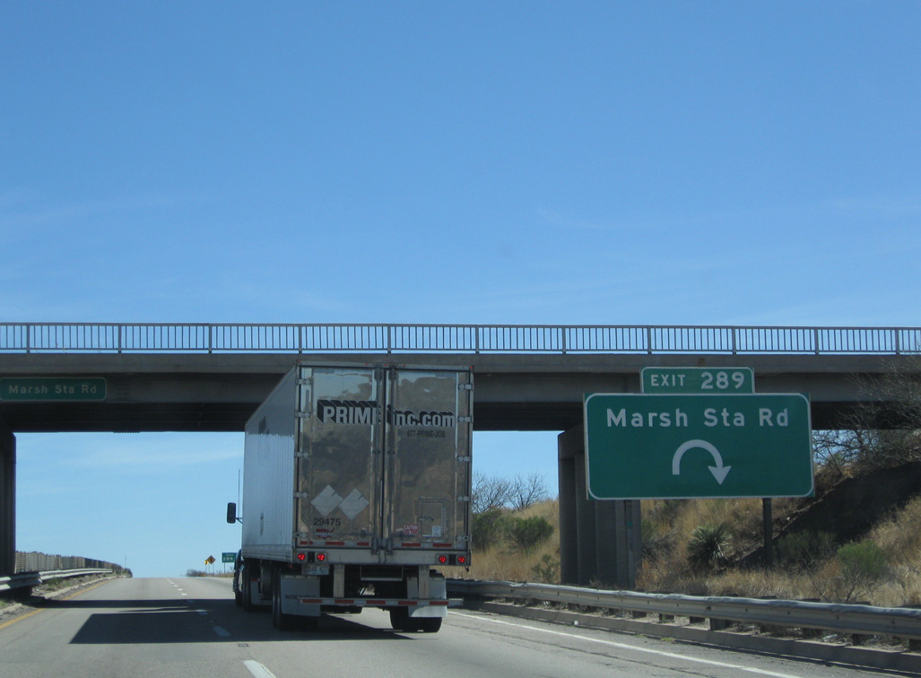
Marsh Station Road was extended east to a diamond interchange (Exit 291) built at the site of a former rest area, and the bridges over Cienega Creek replaced during the 2006-10 road work.3
02/28/09

A ranch exit joins Interstate 10 with Empirita Road in one mile.
02/28/09

02/28/09

11/10/07

This distance sign preceding SR 90 by eight miles replaced a panel showing Willcox at 46 miles.
02/28/09

J-Six Ranch Road north and Mescal Road south come together at Exit 297 in one mile.
02/28/09

Interstate 10 enters Cochise County at the unincorporated community of Mescal.
02/28/09

The first available gas station along Interstate 10 east in 19 miles occurs next at Exit 297.
02/28/09

02/28/09

11/10/07

02/28/09

02/28/09

02/28/09

11/10/07

SR 90 commences south to Huachuca City and Sierra Vista from Interstate 10 at Exit 302 in two miles.
01/13/06
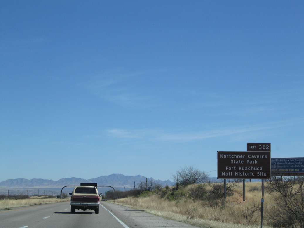
Several state and national parks are located via SR 90 south, including Kartchner Caverns State Park, Coronado National Memorial and various units of Coronado National Forest.
02/28/09

Located 25 miles south of I-10, Sierra Vista has become a regional hub due to its proximity to the Fort Huachuca Military Reservation. The city was incorporated in 1956 and sits west of the historic towns of Tombstone and Bisbee.
02/28/09

Interstate 10 previously made an S-curve across former Southern Pacific Railroad line. The alignment was straightened out during 2011/12 road work.
02/28/09

SR 90 is a divided highway from Interstate 10 south to Whetstone and Huachuca City.
02/28/09

Measuring 46.77 miles in length, SR 90 turns east from SR 92 in Sierra Vista to meet SR 80 midway between Tombstone and Bisbee.
02/28/09

Business Loop I-10 doubles as Historic U.S. 80 east into Downtown Benson. SR 80 branches south from the city to the national historic landmarks of Tombstone, Bisbee and Douglas.
01/13/06
SR 90 stems south from Interstate 10 within western reaches of the Benson city limits.
02/28/09

Benson, which is much smaller than Sierra Vista, features full traveler amenities. Following a 3.50 mile long course, Business Loop I-10 runs along 4th Street between Exit 303 and 306.
01/13/06

Interstate 10 bypasses Benson to the north, next meeting Octillo Avenue at Exit 304.
01/13/06

The diamond interchange (Exit 304) with Octillo Avenue lies just east of a Union Pacific Railroad underpass.
01/13/06

Business Loop I-10 from Benson returns at forthcoming Exit 306 via Pomerene Road north from 4th Street.
01/13/06

Interstate 10 spans the San Pedro River just ahead of Exit 306.
01/13/06

Pomerene Road extends north from the diamond interchange at Exit 306 to the community of Pomerene.
01/13/06

11/10/07

11/10/07

Willcox is 33 miles to the northeast from Benson beyond Texas Canyon and the Willcox Playa.
11/10/07

Interstate 10 crosses Adams Peak north of the UP Railroad siding of Fenner.
11/10/07

The succeeding exit along Interstate 10 east is for Sibyl Road, where a Stuckeys was once located.
11/10/07

11/10/07

11/10/07

Sources:
- Diverging Diamond Interchange - I-10: Houghton Road Traffic Interchange. Arizona Department of Transportation (ADOT), Southcentral District Projects.
- "Major projects to begin construction with federal economic recover funds." Eloy Enterprise, The (AZ), March 18, 2009.
- "A bridge too low: Old railroad span on way out." Arizona Daily Star, The (Tucson, AZ), August 7, 2005.
Photo Credits:
01/13/06, 11/10/07, 02/28/09 by AARoads
Connect with:
Business Loop I-10 - Benson
State Route 83
State Route 80 / Historic U.S. 80
Page Updated 04-11-2022.