 East
East
Named for being on the road to Texas, Interstate 10 enters rocky Texas Canyon, where the freeway ascends from San Pedro Valley and Benson to the high plains around Willcox.
01/13/06

Climbing through Texas Canyon, Interstate 10 passes a series of hillsides strewn with boulders.
01/13/06

Dragoon Road stems 3.76 miles east from the parclo interchange at Exit 318 to the unincorporated community of Dragoon.
11/10/07

The succeeding rest area beyond Texas Canyon is east of San Simon toward the New Mexico border.
11/10/07

Johnson Road is notorious not for the road, but for the attraction at Bowlin's "The Thing" Travel Center. The THING opened in 1965, after being displaced from old US 91 in California1. The Bureau of Indian Affairs investigated The THING? in 2006 after several traveler complaints, but had no findings2.
11/10/07

Exit 322 was well advertised from numerous billboards along Interstate 10 and in Arizona advertising The THING?
11/10/07

Interstate 10 bends northeast between the Steele Hills and Red Bird Hills toward Sulphur Springs Valley.
01/13/06

U.S. 191 travels 67.25 miles south to reach Douglas, on the Arizona/Mexico border. The route was known as U.S. 666 until 1992, when it was rebranded U.S. 191 to eliminate sign thefts and negative cultural connotations.
01/13/06
 East
East  North
North
U.S. 191 overlaps with each even numbered Interstate it meets, including I-40 between Exits 339 and 333; I-70 in Utah between Exits 180 and 156; I-80 in Wyoming between Exits 99 and 104; and I-90 in Montana between Exits 306 and 367.
05/25/03

I-10/U.S. 191 pass north of Willcox Playa along the eight miles leading to Willcox. The two part ways in 20 miles.
01/13/06

The first of three interchanges for Willcox joins I-10/U.S. 191 with Business Loop I-10 at Exit 336.
01/13/06

Business Loop I-10 provides a cut off from I-10/U.S. 191 to SR 186 southeast to Chiricahua National Monument.
11/10/07
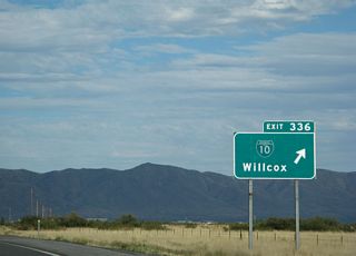
Business Loop I-10 east separates from I-10/U.S. 191 along old U.S. 666 and Haskell Avenue to Downtown Willcox.
11/10/07

Confirming markers for I-10/U.S. 191. The two overlap northeast between milepost 331 and 352.
01/13/06

I-10/U.S. 191 converge with the west end of SR 186 (Rex Allen Drive) at Exit 340 and Fort Grant Drive.
01/13/06

SR 186 travels 33.39 miles southeast to SR 181 west of Chiricahua National Monument. Added to the state highway system in 1956, the number of SR 186 is a legacy from being a branch of former SR 86.
01/13/06

Distance sign to US 191 north, Lordsburg and El Paso. This sign is the first mention of a control city in New Mexico.
01/13/06

One mile ahead of Exit 344 for Business Loop I-10 back into Willcox. This marks the eastern end of the business loop, which is former SR 86.
01/13/06

Exit 344 departs for Willcox and Business Loop I-10. Former SR 86 was replaced by Interstate 10 in 1970.
01/13/06

U.S. 191 extends north from Douglas to Malta, Montana. The only route break is through Yellowstone National Park in Wyoming, because U.S. 191 is closed there during the Winter months.
01/13/06

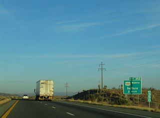
U.S. 191 leads north from Exit 352 to Safford, Clifton and Eagar while connecting with several popular parks, including Petrified Forest National Park via U.S. 180, Canyon de Chelly National Monument, Four Corners and Arches National Park in Utah.
01/13/06
 East
East
The unincorporated community of Bowie is the next population center along I-10 east in 11 miles.
03/01/09

N Page Ranch Road provides a cut off from U.S. 191 southeast to Interstate 10 at Exit 355. Following former SR 86, N Page Ranch Road was previously U.S. 191Y, but decommissioned when ADOT relinquished maintenance.
03/01/09

N Page Canyon Road heads 3.51 miles northwest back to U.S. 191. Until the 2009 ADOT sign replacement project east from U.S. 191 to New Mexico, Exit 355 referenced U.S. 191 for unsigned U.S. 191Y.
03/01/09

Interstate 10 passes through ranching country in Southeastern Arizona. This billboard has been in place for years with the marketing message to eat Beef.
03/01/09

Advance signage to Bowie (6 miles), Lordsburg, New Mexico (56 miles) and El Paso, Texas (217 miles).
03/01/09

Business Loop I-10 connects with Apache Pass Road south to the Fort Bowie National Historical Site. The park commemorates the battles between native Apache Indians and settlers from the east.
03/01/09

Interstate 10 passes through the San Simon Valley east to the Peloncillo Mountains. The freeway east from Bowie to Lordsburg, New Mexico is prone to blowing dust that can dramatically reduce visibility from high winds.
01/13/06

Crossing Apache Pass Road, Interstate 10 advances east to Exit 366 and the return of Business Loop I-10 from Bowie.
03/01/09

Interstate 10 is subject to closure east to New Mexico during strong wind events where blowing dust greatly reduces visibility.
03/01/09

The San Simon Valley once had some of the richest grasslands in Arizona. Unfortunately they were overgrazed in the late 1890s like most of the state. Today San Simon is a small ranching town.
03/01/09

Portal Road stems south from the I-10 frontage road east of Exit 382 to the unincorporated community of Portal.
03/01/09

Exit 382 loops onto Business Loop 10 west for San Simon at W Power Road east to Portal Road.
03/01/09
Sources:
- "Shrine to a Road Scholar: The Thing That Binkley Built on I-10 is Alluring, Enduring." Phoenix New Times (AZ), January 27, 1993.
- The Bureau of Indian Affairs Investigates The Thing.
http://kjzz.org/news/arizona/ archives/200605/thethingreduxNPR Radio, Arizona Week, May 4, 2006.
Photo Credits:
- 05/25/03 by AARoads.
- 01/13/06 by AARoads.
- 11/10/07 by AARoads.
- 03/01/09 by Kevin Trinkle.
Connect with:
Business Loop I-10 - Willcox
U.S. 191
State Route 186
Page Updated 04-11-2022.


