|
| Limestone Road leads south from Kaolin Road and passes below PA 41 (Gap Newport Pike) to connect Chester County with the Upper Pike Creek Valley in Delaware. 12/20/16 |
|
| Southwood Road stems west from Valley Road in Hockessin to meet Limestone Road (SR 3013) just north of the Delaware state line. 12/21/20 |
|
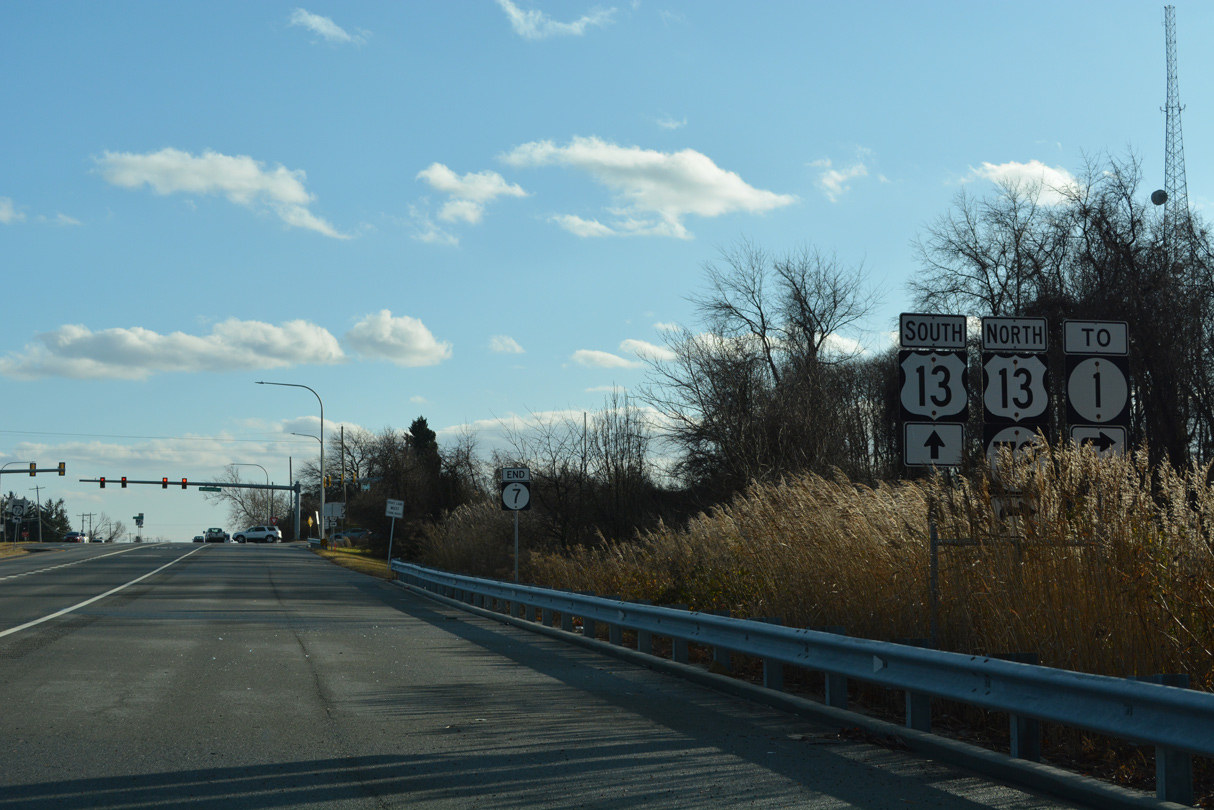
| SR 7 commences to the immediate south of Southwood Road. Limestone Road passes between the Southwood Estate and Stenning Woods subdivisions on the initial stretch through New Castle County. 12/21/20 |
|
| Valley Road heads north from SR 7 (Limestone Road) at Tweeds Park to Hockessin and south to North Star Road. 12/21/20 |
|
| A concrete divider separates single lane traffic to the signalized entrance to Lantana Square Shopping Center. 12/21/20, 12/20/16 |
|
| Brackenville Road provides a second route east to Hockessin from SR 7 (Limestone Road) at Little Baltimore Road. 12/21/20 |
|
| SR 7 (Limestone Road) carries four overall lanes south from Brackenville and Little Baltimore Roads. 12/21/20 |
|
| Haileys Trail east from the Jarrell Farms subdivision and Village Dive west from Mendenhall Village come together at the next signal on SR 7 southbound. 12/21/20 |
|
| Continuing south along the suburban arterial, SR 7 (Limestone Road) meets the north end of SR 72. SR 72 arcs southwest along Paper Mill Road to White Clay Creek State Park and Millford Crossroads. Paper Mill Road leads directly to Chapel Street and Downtown Newark. 12/21/20 |
|
| Limestone Road turns easterly from SR 72 (Paper Mill Road) by the Limestone Hills community. SR 7 and SR 72 come together again at Wrangle Hill. 12/21/20 |
|
| Commuter traffic steadily increases south from SR 72 and the Upper Pike Creek Valley. 2015 traffic counts showed an increase of 20,000 vehicles per day (vpd) southward to SR 2 (Kirkwood Highway). 12/21/20 |
|
| Ochletree Lane joins SR 7 (Limestone Road) with adjacent retail, offices and town homes at the ensuing southbound signal. 12/21/20 |
|
| Stoney Batter Road meanders east from SR 7 at Goldey-Beacom College to Mill Creek Road, forming part of a commuter route to SR 41 (Newport Gap Pike). Skyline Drive north links the state route from the west from adjacent Pike Creek Shopping Center and Pike Creek Golf Course. 12/21/20 |
|
| Linden Hill Road winds south from SR 7 (Limestone Road) and Pike Creek Shopping Center to suburban areas west to Polly Drummond Hill Road. 12/21/20 |
|
| Progressing east, Limestone Road makes a gradual descent, from 289 feet in elevation at Linden Hill Road to 100 feet at Mill Creek. 12/21/20 |
|
| Greenwood Drive represents the lone entrance to the Wood Creek subdivision from SR 7 at this traffic light. 12/21/20 |
|
| A series of S-curves takes SR 7 east by Carousel Park, and across Mill Creek, to the signalized intersection with Arundel Drive and the Arundel subdivision. 12/21/20 |
|
| Milltown Road and McKennans Church Road converge with SR 7 (Limestone Road) south at Milltown. McKennans Church Road branches northeast from Limestone Road to Delcastle Park and SR 41 (Newport Gap Pike) near Hockessin. The north-south road intersects Milltown Road next to SR 7. 12/21/20 |
|
| Milltown Road parallels SR 2 (Kirkwood Highway) west to near Delaware Park and east to SR 41 (Newport Gap Pike) near Prices Corner. 12/21/20 |
|
| Pickwick Drive joins SR 7 (Limestone Road) with Limestone Acres to the west and Limestone Gardens to the east. 12/21/20 |
|
| SR 7 south next reaches the commercialized junction with SR 2 (Kirkwood Highway). 12/21/20 |
|
| A signalized left turn for Midway Shopping Center precedes SR 2 (Kirkwood Highway) on SR 7 (Limestone Road) south. 12/30/16 |
|
| SR 2 constitutes a well traveled arterial route west to the city of Newark and east to Prices Corner and Elsmere. The divided highway was completed by 1949. 12/21/20 |
|
| Peak hour congestion is a regular occurrence at the cross roads of SR 2 (Kirkwood Highway) and SR 7 (Limestone Road). Shopping centers occupy all four corners of the intersection. 12/21/20 |
|
| Limestone Road advances south from Kirkwood Highway between the Klair Estates subdivision and several apartment complexes. SR 7 is unmarked to Hendry Avenue. 12/30/16 |
|
| SR 7 (Limestone Road) spans a CSX Railroad line ahead of back to back signals for Laura Drive west and Tarry Lane east. The residential roads connect with the Manette Heights and Rolling Hills subdivisions respectively. 12/30/16 |
|
| SR 7 enters the unincorporated community of Stanton at SR 4 (Main Street / Mitch Road). 12/30/16 |
|
| Dual turn lanes separate traffic for SR 4 (Mitch Road) east to Newport Pike and the 1.2 mile overlap of SR 4 west / SR 7 south to Churchmans Crossing. 12/30/16 |
|
| The turn onto SR 4 (Mitch Road) east includes access to Mill Road, a short residential street. 12/23/05 |
|
| The one way couplet of SR 4 through Stanton extends to east of Red Clay Creek. The state route reaches the town of Newport in 1.75 miles and ends in Wilmington. 07/31/13 |
|
| A 2017-installed distance sign for Christiana and Dover stands along Main Street after the merge of SR 4 west / SR 7 south. 12/21/17 |
|
| Main Street west combines with Mitch Road east ahead of the SR 4/7 intersection with Telegraph Road. Telegraph Road comprises a local through route in conjunction with Old Capitol Trail or St. James Church Road north to SR 2 (Kirkwood Highway). 12/21/17 |
|
| SR 4/7 expand into a six lane, controlled access arterial south ahead of Delaware Park Boulevard. 12/21/17 |
|
| Delaware Park Boulevard loops west through Delaware Park to SR 4 and SR 58 near Christiana Hospital. Delaware Park is home to thoroughbred racing, a casino with slot machine gambling and an 18 hole golf course. 12/30/16 |
|
| SR 4/7 cross White Clay Creek on a 533.2 foot long bridge built in 1981.1 12/25/20 |
|
| Road 336F links SR 4/7 with Stanton Christiana Road, the former alignment of SR 7 south from White Clay Creek and Stanton. 12/23/22 |
|
| SR 4/7 proceed south from Road 336F across the AMTRAK Northeast Corridor. 12/25/20 |
|
| A parclo interchange (Exit 166) joins SR 7 (Stanton Christiana Road) with SR 58 (Churchmans Road) one mile south of the AMTRAK bridge. 12/25/20 |
|
| Stanton Christiana Road (Road 336D) ties into SR 4/7 at the south end of the Stanton Bypass. SR 4 originally branched west from SR 7 along Road 358B (Ogletown Stanton Road) to Old Churchmans Road (Road 315). 12/23/22 |
|
| SR 4/7 split at the ensuing intersection with Stanton Ogletown Road west and the entrance to Morgan Christiana Center 09/27/14 |
|
| SR 4 branches west from SR 7 (Stanton Christiana Road) along Ogletown Stanton Road toward Newark. 12/23/22 |
|
| SR 4 (Ogletown Stanton Road) heads 1.3 miles west to the entrance of Christiana Hospital and 2.88 miles to SR 273 and Salem Church Road at Ogletown. 12/25/20 |
|
| A large confirming marker for SR 7 south stands beyond the partition with SR 4 west. Twin C Road, the west side service road, represents the original alignment of SR 7/Stanton Christiana Road. 12/25/20 |
|
| Exit 166 follows AAA Boulevard from SR 7 south to both SR 58 (Churchmans Road) and the collector distributor roadway for Interstate 95 (JFK Memorial Highway). 12/23/22 |
|
| AAA Boulevard / Del-Tech Connector (Rd 339B) leads to the adjacent Stanton Campus of Delaware Technical & Community College (DTCC). 12/23/22 |
|
| A begin shield for SR 1 was formerly posted at the overpass spanning SR 58. SR 1 overtook SR 7 south to Christiana when it was completed. 12/23/22 |
|
| SR 58 constitutes a heavily traveled arterial west to Christiana Hospital and SR 4. The state route reduces to two lanes east en route to SR 37 (Airport Road) and SR 273 near Hares Corner. 08/17/21 |
|
| Motorists continuing south to I-95 must first contend with the traffic lights at Churchmans Road (SR 58). A direct on-ramp to the I-95 c/d roadway was designed but never implemented. 12/22/18 |
|
| A concrete barrier remains along SR 1/7 south between the single lane mainline and adjacent c/d roadway for I-95. This configuration was made in 1998 when Exit 166 for SR 58 opened to traffic. 08/17/21 |
|
| SR 1 formally begins along SR 7 south at the center line of Interstate 95. The two overlap 0.72 miles to Exit 164 B for Road A. Exit 164 A leads to Christiana Mall directly. 12/23/22 |
|
| A folded diamond interchange (Exit 164 B) adjacent to Christiana Mall joins SR 1 with Road A leading SR 7 southbound back to Stanton Christiana Road. 12/25/20 |
|
| SR 7 loops away from SR 1 south at Exit 164 B for Christiana. SR 1 parallels the remainder of SR 7 south to Wrangle Hill. 12/25/20 |
|
| SR 7 rejoins Stanton Christiana Road south just west of SR 1. Stanton Christiana Road north links with Eagle Run Road west to SR 273. An apartment complex was constructed along the west side of the previously rural stretch in 2015. 08/18/21 |
|
| SR 7 rises to cross a tributary of the Christiana River ahead of the Edgebrooke subdivision. Stanton Christiana Road becomes Old Baltimore Pike as the state route enters the unincorporated community of Christiana. 08/18/21 |
|
| Old Baltimore Pike (Road 26) curves southwest through the heart of Christiana and intersects Main Street (old SR 273). SR 7 turns south on E Main Street while Old Baltimore Pike heads west along a suburban corridor between I-95 and U.S. 40. 08/18/21 |
|
| E Main Street leads SR 7 south from Christiana toward Bear. The route is unmarked after Old Baltimore Pike. 12/30/16 |
|
| SR 7 (E Main Street) makes an S-curve traveling out from Christiana to span the Christina River on a 1937-built bridge. Prior to the mid 1980s, E Main Street doubled as both SR 7 and SR 273. 12/30/16 |
|
| SR 7 (E Main Street) comes together with SR 273 (Christiana Bypass) just west of the diamond interchange with SR 1. 12/30/16 |
|
| The Christiana Bypass alignment of SR 273 encircles Christiana west to Old Baltimore Pike and north to Chapman Road and Interstate 95. SR 273 travels 12.7 miles overall from SR 9/141 at New Castle to MD 273 west of Newark. 12/30/16 |
|
| SR 7 expands into a four lane arterial south from SR 273 (Christiana Bypass) to U.S. 40 (Pulaski Highway) in Bear. SR 273 also follows an arterial route east to Hares Corner and west to Ogletown. 12/30/16 |
|
| Continuing south from SR 273, SR 7 (Bear Christiana Road) passes west by a pair of apartment complexes and east of a DelDot facility. The state route was expanded from two to four lanes between SR 273 and Newtown Road by 2014. 12/26/22 |
|
| Expansion of SR 7 added a traffic light for School Bell Road east. School Bell Road (Road 344) weaves 1.31 miles south between the Jamestowne, Whethersfield and Fairwoods subdivisions to U.S. 40 (Pulaski Highway) near State Road. 12/26/22 |
|
| The succeeding signal on SR 7 (Bear Christiana Road) operates at Christiana Meadows and the DelDOT entrance. 12/26/22 |
|
| A reassurance marker for SR 7 stands south of Christiana Meadows and Springwood Drive. 12/26/22 |
|
| Rivers End Drive heads west from Bear Christiana Road between a number of subdivisions to Smalleys Dam Road (Road 345). 12/26/22 |
|
| Newtown Road links SR 7 with Smalleys Dam Road and the Brooksfield subdivision to the west. A proposed wye interchange with SR 1 may tie into this intersection from the east. 12/26/22 |
|
| South from Newtown Road (Road 68), SR 7 progresses into Bear, an unincorporated suburban area centered around the commercial cross roads with U.S. 40 (Pulaski Highway). 12/26/22 |
|
| Songsmith Drive circles south from Smalleys Dam Road to the Spring Mill subdivision and east by Governors Square shopping center to SR 7. An extension of the road loops east to adjacent big box retail. 12/26/22 |
|
| Governors Square shopping center lines the north side of forthcoming U.S. 40 (Pulaski Highway). U.S. 40 represents the main route across Bear, joining the community with Glasgow to the west and U.S. 13 (Dupont Highway) at State Road to the east. 12/26/22 |
|
| Formerly a cross country route from San Francisco, California to Atlantic City, New Jersey, the Delaware portion of U.S. 40 generally serves local traffic west from the split with U.S. 13 to Elkton, Maryland. 12/26/22 |
|
| Edens Square and Glendale Plaza add traffic to the intersection with U.S. 40 and SR 7 from the south side of Pulaski Highway. Long standing plans call for the addition of an overpass for SR 7 here to relieve congestion. 12/26/22 |
|
| Narrowing to two lanes, SR 7 follows Bear Corbitt Road south from U.S. 40 to cross a Norfolk Southern Railroad line at-grade. 12/26/22 |
|
| SR 71 (Red Lion Road) angles southwest from U.S. 13 (Dupont Highway) at Tybouts Corner to cross paths with SR 7 at Red Lion. SR 71 extends southwest to Williamsburg, Kirkwood and Lums Pond to connect with SR 896 south across the Summit Bridge. 12/23/22 |
|
| Bear Corbitt Road leads SR 7 south from Red Lion toward Wrangle Hill. 12/23/22 |
|
| Prior to the 1993-95 construction of SR 1 south from Tybouts Corner, SR 7 (Bear Corbitt Road) ended at U.S. 13 (Dupont Highway). SR 1 displaced a portion of Dupont Highway north across Red Lion Creek, with two sections of the former alignment repurposed as local roads. 12/23/22 |
|
| SR 7 was extended south over Dupont Highway to connect with U.S. 13 and SR 72 at Wrangle Hill. The state route passes below U.S. 13/SR 1 ahead of a Norfolk Southern Railroad spur. 12/23/22 |
|
| Trailblazers direct motorists to U.S. 13 and SR 1 as Dupont Highway briefly expands to two southbound lanes. 12/23/22 |
|
| Forthcoming SR 72 links U.S. 13 and SR 7 with SR 9 south to Delaware City. The 17.4 mile long route arcs northwest to Newark and northeast to the Upper Pike Creek Valley. 12/23/22 |
|
| SR 7 south concludes as U.S. 13 overtakes Dupont Highway south to North St. Georges and the St. Georges Bridge. 12/23/22 |
|
| SR 72 (Wrangle Hill Road) leads 1.50 miles east to SR 9 (River Road) at Clarks Corner Road (Road 378) and the Delaware City Refinery. 12/23/22 |
|
| U.S. 13 north dog legs west from Dupont Highway to the diverging diamond interchange (DDI) joining SR 72 with SR 1. 12/23/22 |
12/23/05, 07/31/13, 09/27/14, 12/20/16, 12/30/16, 12/21/17, 12/22/18, 12/21/20, 12/25/20, 08/17/21, 08/18/21, 12/23/22, 12/26/22 by AARoads
Page Updated 01-07-2023.


 South
South


 West
West