

Interstate 210 West - California 57 to California 134
| Interstate 210 (Foothill Freeway) west | |
|---|---|
 |
Traffic from California 210 (Foothill Freeway) and California 57 (Orange Freeway) merge together to form Interstate 210 west at the Glendora Curve Interchange. California 210 will become Interstate 210 once interchange improvements at Interstate 215 and Interstate 210 are completed in San Bernardino (expected in November 2011).1 This mileage sign (as seen from the California 57 transition lanes) provides the distance to the next three exits along Interstate 210 west: Exit 43, Sunflower Avenue; Exit 42, Grand Avenue; and Exit 41, Citrus Avenue. Photo taken 07/04/07. |
 |
This is the first Interstate 210 westbound shield now that the Interstate 210 designation has been retracted to its new temporary eastern terminus at its junction with California 57 (Orange Freeway). Once California 210 is complete (expected in 2007), the entire route from Sylmar to Redlands will be resubmitted to AASHTO for inclusion in the Interstate Highway System as Interstate 210. Photo taken 07/03/04. |
 |
The next exit along Interstate 210 (Foothill Freeway) west is Exit 43, Sunflower Avenue, which heads south into Glendora, then into Charter Oak and Covina. Photo taken 07/04/07. |
 |
This older-style reassurance marker features the Interstate 210 shield and word "Freeway," but the name "Foothill Freeway" is omitted. Compare this sign to others like it found in Los Angeles County (Caltrans District 7) along Interstate 405 (San Diego Freeway) and U.S. 101 (Ventura Freeway), among others. Photo taken 07/03/04. |
 |
Westbound Interstate 210 (Foothill Freeway) reaches Exit 43, Sunflower Avenue. Photo taken 07/04/07. |
 |
This mileage sign along Interstate 210 (Foothill Freeway) west provides the distance to Azusa (three miles), Monrovia (nine miles), and Pasadena (17 miles). Photo taken 07/04/07. |
 |
The next exit along Interstate 210 (Foothill Freeway) west is Exit 42, Grand Avenue to Glendora. From California 57 west to the Barranca Avenue grade separation, Interstate 210 passes through the city of Glendora ("The Pride of the Foothills," population 49,415 as of the 2000 Census, incorporated on November 13, 1911), with significant portions to the north and south of the freeway. Photo taken 07/04/07. |
 |
This mileage sign along Interstate 210 (Foothill Freeway) west provides the distance to the next three exits: Exit 42, Grand Avenue to Glendora; Exit 41, Citrus Avenue; and Exit 40, California 39 (Azusa Avenue). Photo taken 07/04/07. |
 |
Westbound Interstate 210 reaches Exit 42, Grand Avenue. Use Grand Avenue to enter Glendora. Photo taken 07/04/07. |
 |
The next exit along westbound Interstate 210 (Foothill Freeway) is Exit 41, Citrus Avenue. Photo taken 04/26/08. |
 |
This interchange sequence sign provides the distance to the next three exits along westbound Interstate 210: Exit 41, Citrus Avenue; Exit 40, California 39 (Azusa Avenue); and Exit 39, Vernon Avenue. Photo taken 07/04/07. |
 |
These three exits serve the city of Azusa (population 44,712 as of the 2000 Census and December 29, 1898). Photo taken 04/26/08. |
 |
Use Exit 41 to Azusa Pacific University and Citrus College. Photo taken 04/26/08. |
 |
Westbound Interstate 210 (Foothill Freeway) reaches Exit 41, Citrus Avenue north to Azusa and south to Covina. Photo taken 04/26/08. |
 |
The next exit along westbound Interstate 210 (Foothill Freeway) is Exit 40, California 39 (Azusa Avenue) north to Azusa. Azusa Avenue is signed as California 39 through the city, but it is maintained by the city of Azusa. North of Interstate 210, Azusa Avenue splits into a one-way couplet with San Gabriel Avenue. The one-way couplet consolidates into San Gabriel Canyon Road north of downtown, and state maintenance resumes on San Gabriel Canyon Road upon exiting the city of Azusa. Photo taken 07/04/07. |
 |
This mileage sign provides the distance to the next three exits along Interstate 210 (Foothill Freeway) west: Exit 40, California 39 (Azusa Avenue); Exit 39, Vernon Avenue; and Exit 38, Irwindale Avenue. Photo taken 07/04/07. |
 |
Westbound Interstate 210 (Foothill Freeway) meets Exit 40, California 39 (Azusa Avenue). Photo taken 04/26/08. |
 |
The off-ramp from Interstate 210 (Foothill Freeway) west to California 39 turns north and meets First Street (a frontage road) at this traffic signal. Turn left (west) on First Street to connect to California 39 (Azusa Avenue). Photo taken 04/26/08. |
 |
Back on the mainline and after the off-ramp to California 39 (Azusa Avenue) (Exit 40), the next exit along westbound Interstate 210 is Exit 39, Vernon Avenue (one-half mile). Photo taken 07/03/04. |
 |
This mileage sign provides the distance to the next three exits along westbound: Exit 39, Vernon Avenue; Exit 38, Irwindale Avenue; and Exit 36B, Interstate 605 (San Gabriel River Freeway) south to Long Beach. Photo taken 07/04/07. |
 |
Westbound Interstate 210 (Foothill Freeway) reaches Exit 39, Vernon Avenue. Photo taken 07/04/07. |
 |
This mileage sign provides the distance to the next three exits along Interstate 210 west: Exit 38, Irwindale Avenue; Exit 36B, Interstate 605 (San Gabriel River Freeway); and Exit 36A, Mount Olive Drive. Photo taken 07/04/07. |
 |
The carpool (high occupancy vehicle) lane continues west, one of the longest continuous such lanes connecting San Bernardino and Pasadena. Photo taken 07/04/07. |
 |
Exit 38 links SR 210 with the Santa Fe Dam Recreation Area, a park operated and maintained by Los Angeles County. The park is located adjacent to the city of Irwindale. Photo taken 07/04/07. |
 |
Interstate 210 enters the city of Irwindale (population 1,446 as of the 2000 Census and incorporated on August 6, 1957). The city is known for its rock quarries (several of which are located on either side of Interstate 605 south of Interstate 210) and is home to the annual Southern California Renaissance Pleasure Faire. Photo taken 07/04/07. |
 |
Westbound Interstate 210 (Foothill Freeway) meets Exit 38, Irwindale Avenue. At this point, Interstate 210 departs Azusa and enters the city of Irwindale. Use this exit to access the Santa Fe Dam Recreation Area to the southwest of this interchange. The next interchange is Exit 36B, Interstate 605 (San Gabriel River Freeway) south to Long Beach. Photo taken 07/04/07. |
 |
This mileage sign provides the distance to the next three exits along Interstate 210 west: Exit 36B, Interstate 605 (San Gabriel River Freeway); Exit 36A, Mount Olive Drive; and Exit 35B, Buena Vista Street. Photo taken 07/04/07. |
 |
To continue west on Interstate 210, remain in the four left lanes or continue in the high occupancy vehicle lane. To exit onto southbound Interstate 605, use the two right lanes. Note that no control city is used for Interstate 605; Interstate 605 serves Baldwin Park, El Monte, Pico Rivera, Norwalk, Bellflower, Cerritos, Lakewood, and ultimately Long Beach and Seal Beach. Photo taken 07/03/04. |
 |
Use Exit 36A (Mount Olive Drive north) to Bradbury and to Historic U.S. 66. Photo taken 07/04/07. |
 |
The Santa Fe Dam Recreation Area is visible to the south from Interstate 210 west. A set of Southern California Edison power lines (220kV) passes over the freeway. Interstate 210 approaches the city of Duarte (population 21,486 as of the 2000 Census and incorporated on August 22, 1957). Photo taken 07/04/07. |
 |
Westbound Interstate 210 (Foothill Freeway) reaches Exit 36B, Interstate 605 (San Gabriel River Freeway) south to Seal Beach. Since the connection to Interstate 710 has not been constructed and Pasadena city streets must be used to connect to California 110, a connection to downtown Los Angeles may be reached via south Interstate 605 to west Interstate 10. Photo taken 07/04/07. |
 |
Immediately thereafter, Interstate 210 enters the Interstate 605 stack interchange. Just as we pass under the sprawling ramps above, an off-ramp connects Interstate 210 west with Exit 36A, Mount Olive Drive north to Duarte and Bradbury. At this ramp, Interstate 10 departs Irwindale and enters Duarte. This ramp actually connects with northbound Interstate 605 traffic; as soon as the ramp merges with Interstate 605, the freeway prepares to end at a traffic signal with former U.S. 66 at Huntington Drive. U.S. 66 parallels Interstate 210 between California 57 and Pasadena; through Azusa, U.S. 66 is known as Foothill Boulevard, while in Duarte, U.S. 66 changes names to Huntington Drive. Photo taken 07/04/07. |
 |
The next exit along Interstate 210 (Foothill Freeway) is Exit 35B, Buena Vista Street in western Duarte (one mile). Note that there is a truck restriction for Buena Vista Street, just as there was one for Mount Olive Drive. Photo taken 07/04/07. |
 |
This Interstate 210 west reassurance shield (neutered) is posted after the on-ramp from Interstate 605 north to Interstate 210 west. Photo taken 09/29/07. |
 |
Interstate 210 west approaches Exit 35B, Buena Vista Street. Photo taken 09/29/07. |
 |
This mileage sign along Interstate 210 west provides the distance to the next three exits: Exit 35B, Buena Vista Street; Exit 35A, Mountain Avenue; and Exit 34, Myrtle Avenue. Photo taken 07/04/07. |
 |
Another mileage sign along Interstate 210 west provides the distance to Monrovia (one mile), Arcadia (four miles), and Pasadena (nine miles). Photo taken 09/29/07. |
 |
Westbound Interstate 210 reaches Exit 35B, Buena Vista Street north to Duarte and south to Irwindale. The next exit is Exit 35A, Mountain Avenue. Photo taken 09/29/07. |
 |
An Interstate 210 west guide sign is posted between the off-ramps for Exits 35B and 35A. Photo taken 09/29/07. |
 |
The next exit along westbound is Exit 35A, Mountain Avenue. The ramp actually connects to a collector distributor lane (Central Avenue) that parallels Interstate 210 roughly between Exit 35B/Buena Vista Street and Exit 34/Myrtle Avenue in Monrovia. The parallel frontage road on the south side of Interstate 210 is Evergreen Avenue, and the exits are similarly arranged in the eastbound direction. Photo taken 09/29/07. |
 |
This mileage sign provides the distance to the next three exits along westbound: Exit 34, Myrtle Avenue; Exit 33, U.S. 66/Huntington Drive; and Exit 32, Santa Anita Avenue. Photo taken 09/29/07. |
 |
Looking over at the collector distributor lanes for Exit 35B is this overhead sign directing traffic to the off-ramp to Exit 35B, Mountain Avenue and a return sign back to the mainline freeway. Photo taken 09/29/07. |
 |
Stay left to merge onto the carpool (HOV) lane. Photo taken 09/29/07. |
 |
Interstate 210 departs Duarte and enters the city of Monrovia (population 36,929 as of the 2000 Census and incorporated on December 15, 1887). This sign is posted at the point where Interstate 210 crosses over Mountain Avenue. Photo taken 09/29/07. |
 |
The next exit along Interstate 210 (Foothill Freeway) west is Exit 34, Myrtle Avenue. Use Myrtle Avenue north to reach downtown Monrovia. Photo taken 09/29/07. |
 |
Westbound Interstate 210 (Foothill Freeway) reaches Exit 34, Myrtle Avenue to Monrovia. Use the right lane (exit only) to exit onto Myrtle Avenue. The left four lanes plus the high occupancy vehicle (carpool) lane continue through toward Pasadena. Photo taken 09/29/07. |
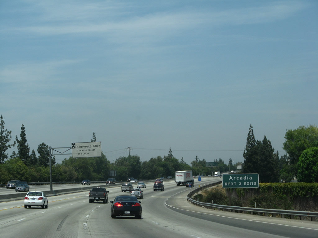 |
The next three exits along westbound Interstate 210 all serve the city of Arcadia: Exit 33, Historic U.S. 66/Huntington Drive; Exit 32, Santa Anita Avenue; and Exit 31, Baldwin Avenue. Photo taken 07/04/07. |
 |
This mileage sign provides the distance to the next three exits along Interstate 210 west: Exit 33, Historic U.S. 66/Huntington Drive; Exit 32, Santa Anita Avenue; and Exit 31, Baldwin Avenue. Photo taken 07/15/09. |
 |
Each of the aforementioned exits (Exit 33, Historic U.S. 66/Huntington Drive; Exit 32, Santa Anita Avenue; and Exit 31, Baldwin Avenue) will provide access to the Santa Anita Park Racetrack. Photo taken 07/15/09. |
 |
Westbound Interstate 210 (Foothill Freeway) meets Exit 33, U.S. 66/Huntington Drive. U.S. 66 continues west along Huntington Avenue through Monrovia, and at this point, Interstate 210 turns northwest, crossing U.S. 66 as it turns. Use U.S. 66/Huntington Drive west to enter the city of Arcadia (after passing North 5th Avenue) and reach Arcadia County Park, Santa Anita Park, and the racetrack. Upon reaching the racetrack, U.S. 66 turns northwest along Colorado Place, while Huntington Drive turns southeast separate from U.S. 66 toward San Marino. Photo taken 09/29/07. |
 |
The next exit along Interstate 210 (Foothill Freeway) is Exit 32, Santa Anita Avenue (0.75 mile). Photo taken 09/29/07. |
 |
Interstate 210 leaves Monrovia and enters the city of Arcadia, which had a population of 53,248 as of the 2000 Census and incorporated on August 5, 1903. Many cities along this portion of Interstate 210 (that are located within the San Gabriel Valley) incorporated early and lie along sections of Historic U.S. 66. The right two lanes of Interstate 210 west become exit only for Exit 32, Santa Anita Avenue. Photo taken 09/29/07. |
 |
This mileage sign provides the distance to the next three exits along Interstate 210 west: Exit 32, Santa Anita Avenue; Exit 31, Baldwin Avenue; and Exit 30, California 19 (California 164)/Rosemead Boulevard and Michillinda Avenue. Interstate 210 leaves Monrovia and now enters Arcadia immediately after the U.S. 66/Huntington Drive interchange. Photo taken 07/15/09. |
 |
Westbound Interstate 210 meets Exit 32, Santa Anita Avenue in Arcadia. Photo taken 07/04/07. |
 |
Use Exit 31 (Baldwin Avenue) to the Los Angeles County Arboretum and Botanic Garden. Photo taken 09/29/07. |
 |
The next exit along Interstate 210 (Foothill Freeway) west is Exit 31, Baldwin Avenue (0.75 mile). Photo taken 09/29/07. |
 |
This mileage sign provides the distance to the next two exits along Interstate 210 (Foothill Freeway) west: Exit 31, Baldwin Avenue and Exit 30, California 19 (164)/Rosemead Boulevard and Michillinda Avenue. Photo taken 07/04/07. |
 |
Westbound Interstate 210 meets Exit 31, Baldwin Avenue (collector distributor lane exit, so through traffic may depart the freeway here and rejoin the main lanes). Use Baldwin Avenue north to reach Sierra Madre and south to Arcadia, including the Los Angeles County Arboretum. Prior to the next exit, Interstate 210 departs Arcadia, briefly flirts with unincorporated county, then will enter the city of Pasadena. Photo taken 07/03/04. |
 |
A carpool entrance/exit is located immediately after the Exit 31 off-ramp. Photo taken 07/15/09. |
 |
The next exit along Interstate 210 (Foothill Freeway) west is Exit 30, California 19 (164)/Rosemead Boulevard and Michillinda Avenue. This interchange, which is located on the border between Pasadena to the north and unincorporated Los Angeles County to the south, marks the northern terminus of California 19 and hidden California 164. California 19 is the signed route number for Rosemead Boulevard through the unincorporated area, Temple City, Rosemead, El Monte, and South El Monte. Upon reaching the city limit of Pico Rivera and the intersection with Gallatin Road, California 164 magically changes into California 19. The reason for this is because California 164 was originally planned to be a freeway (Rio Hondo Freeway) that would start at Interstate 605 east of Pico Rivera and southwest of Whittier, then continue north over the San Gabriel River, then joining Rosemead Boulevard in northern Pico Rivera. This freeway definition was eliminated in 2004, so now California 164 merely picks up where California 19 leaves off. However, to allow for consistency and avoid motorist confusion with both California 19 and California 164, Rosemead Boulevard is (and has been) signed solely as California 19.2 Photo taken 09/29/07. |
 |
These signs are posted on the collector distributor lanes for Exit 31, Baldwin Avenue. Photo taken 07/04/07. |
 |
This mileage sign provides the distance to the next two exits along Interstate 210 west: Exit 30, California 19 (California 164)/Rosemead Boulevard and Michillinda Avenue and Exit 29B, Madre Street. Photo taken 09/29/07. |
 |
Westbound Interstate 210 reaches Exit 30, California 19 (California 164)/Rosemead Boulevard and Michillinda Avenue. As for California 19, it legislatively exists between California 1 (Pacific Coast Highway) and Gallatin Avenue in Pico Rivera; as noted earlier, the rest of Rosemead Boulevard north of Gallatin Avenue is legislatively California 164. The remainder of California 19 is slowly being decommissioned by the state, with several sections already removed (such as the segments within the city limits of Long Beach and Downey). Active proposals call for the removal of California 19 from the state highway system in Bellflower, Downey, and Pico Rivera. Photo taken 07/04/07. |
 |
The next exit along westbound Interstate 210 is Exit 29B, Madre Street/Sierra Villa Avenue, 0.75 mile. The next ten exits all serve Pasadena: Exit 29B, Madre Street and Sierra Villa Avenue; Exit 29A, Sierra Madre Boulevard; Exit 27B, Allen Avenue; Exit 27A, Hill Avenue; Exit 26B, Lake Avenue; Exit 26A, California 134 (Ventura Freeway) West, California 710 south to Del Mar Boulevard and California Boulevard, and Historic U.S. 66 (Colorado Boulevard) (Left Exit); Exit 25B, Fair Oaks Avenue North; Exit 25A, Fair Oaks Avenue South; Exit 24, Seco Street/Mountain Street; Exit 23, Lincoln Avenue; and Exit 22B, Arroyo Boulevard. Photo taken 07/04/07. |
 |
The off-ramp to Exit 30 is visible from the main lanes. A sign advises of the off-ramp split between north and south Rosemead Boulevard. California 19-164 travels south from this interchange but not north since this interchange is the northern terminus for the state route. Photo taken 07/15/09. |
 |
After passing the California 19 (164) interchange, Interstate 210 enters the city of Pasadena (incorporated on June 19, 1886, with a population of 133,936 as of the 2000 Census). The next exit is Exit 29B, Madre Street and Sierra Madre Villa Avenue. Photo taken 09/29/07. |
 |
An auxiliary sign for Sierra Madre Villa Avenue is posted on the side of the freeway. Photo taken 07/04/07. |
 |
Westbound Interstate 210 (Foothill Freeway) reaches Exit 29B, Madre Street south/Sierra Madre Villa Avenue north. The next exit is Exit 29A, Sierra Madre Boulevard south to San Marino and north to Pasadena's Victory Park. Note that between Exits 29B and 25B/26A within Pasadena, a light rail track (Metro Gold Line) runs through the median of Interstate 210. This is a relative rarity in greater Los Angeles; Interstate 105/Anderson Freeway also has the feature of light rail in the median. Photo taken 07/04/07. |
 |
An overpass connects a parking garage to the Metro Gold Line terminal. Photo taken 09/29/07. |
 |
The next exit along Interstate 210 (Foothill Freeway) west is Exit 29A, Sierra Madre Boulevard north/south and San Gabriel Boulevard south. Sierra Madre Boulevard is a major arterial that originates in Sierra Madre to the northeast, heads west into Pasadena, then turns south at Victory Park en route to Interstate 210. South of Interstate 210, Sierra Madre Boulevard continues into San Marino, changing into San Marino Boulevard upon meeting Huntington Drive. Photo taken 07/04/07. |
 |
The right lane of Interstate 210 (Foothill Freeway) west becomes exit only for Exit 29A, Sierra Madre Boulevard north/south and San Gabriel Boulevard south. Photo taken 09/29/07. |
 |
Use Exit 29A to San Gabriel Boulevard and Altadena Drive. Photo taken 09/29/07. |
 |
Westbound Interstate 210 (Foothill Freeway) meets Exit 29A, Sierra Madre Boulevard and San Gabriel Boulevard. The next exit along Interstate 210 west is Exit 27B, Allen Avenue. Photo taken 09/29/07. |
 |
 |
Over in the carpool/HOV lane, this pair of signs advises HOV motorists to leave the carpool lane to remain on Interstate 210 west or to connect to Interstate 710 south (although this sign is misleading, since Interstate 710 does not yet extend north to Pasadena). The unsigned California 710 spur does lead south briefly but ends after a couple of dispersal exits. Photos taken 07/15/09. |
 |
Use Exit 27B, Allen Avenue south to the Huntington Library, Art Collections, and Botanical Gardens in the city of San Marino (population 12,945 as of 2000 Census; incorporated on April 25, 1913). Interstate 210 does not enter San Marino but instead continues due west toward downtown Pasadena. Photo taken 09/29/07. |
 |
This mileage sign provides the distance to the next three exits along Interstate 210 (Foothill Freeway) west: Exit 27B, Allen Avenue; Exit 27A, Hill Avenue; and Exit 26B, Lake Avenue. Photo taken 07/04/07. |
 |
An Interstate 210 west reassurance shield is posted just prior to the off-ramp for Exit 27B, Allen Avenue. Photo taken 09/29/07. |
 |
Westbound Interstate 210 (Foothill Freeway) reaches Exit 27B, Allen Avenue. The next exit along westbound is Exit 27A, Hill Avenue. Photo taken 07/04/07. |
 |
To the unincorporated community of Altadena (located north of Pasadena), use Exit 26B, Lake Avenue north rather than the next exit, which is Exit 27A, Hill Avenue. An exit number would be helpful for a sign like this one. Photo taken 07/04/07. |
 |
This mileage sign provides the distance to the next three exits along Interstate 210 (Foothill Freeway) west: Exit 27A, Hill Avenue; Exit 26B, Lake Avenue; and Exit 26A, Fair Oaks Avenue to Historic U.S. 66 (Colorado Boulevard). Photo taken 09/29/07. |
 |
Westbound Interstate 210 (Foothill Freeway) meets Exit 27A, Hill Avenue. Use Hill Avenue south to Pasadena City College and the California Institute of Technology (Caltech). Photo taken 09/29/07. |
 |
Use Exit 26B to Lake Avenue and Los Robles Avenue. Photo taken 09/29/07. |
 |
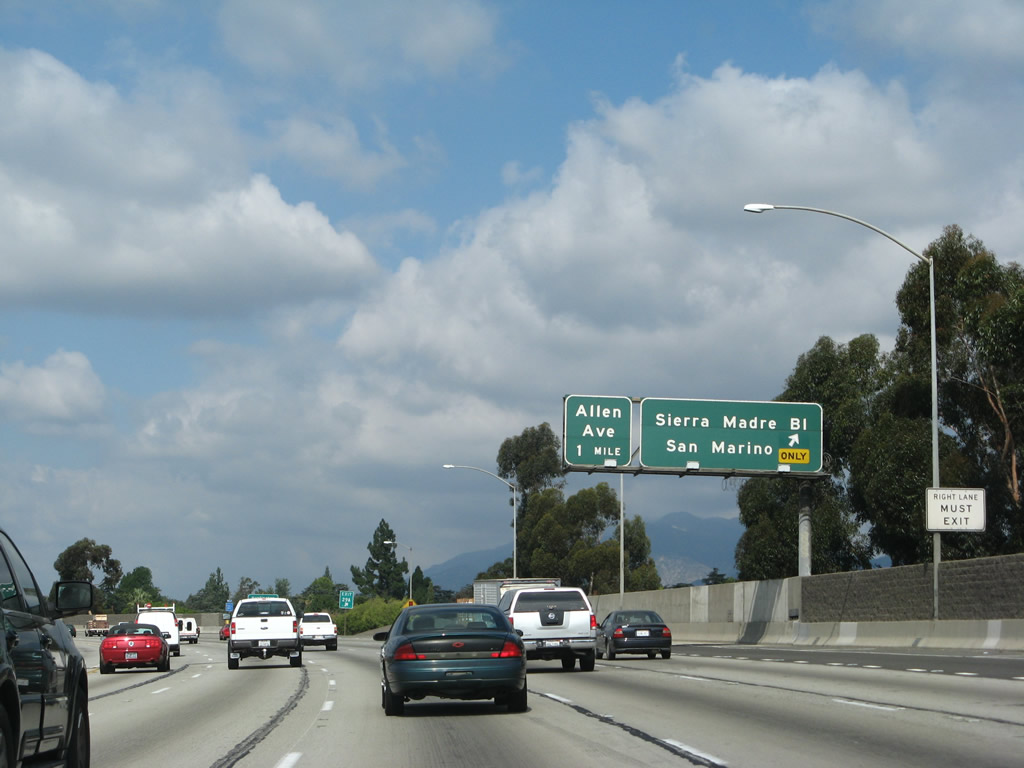
This mileage sign provides the distance to the next three exits along Interstate 210 (Foothill Freeway) west: Exit 26B, Lake Avenue; Exit 26A, California 134 (Ventura Freeway) west, California 710 south to Del Mar Boulevard, California Boulevard, and California 110/Arroyo Seco Parkway (Left Exit); and Exit 25B, Fair Oaks Avenue North. Because of the arrangement of the exit ramps, Exit 25B/Fair Oaks Avenue and Marengo Drive appears on the mileage sign prior to Exit 26A (California 134 west and California 710 south to California 110). Photo taken 09/29/07. |
 |
This is the final chance for carpool/HOV traffic to depart the diamond lane and return to the main lanes to continue west on Interstate 210. All carpool traffic are otherwise defaulted onto California 134 ahead. Photo taken 07/15/09. |
 |
Westbound Interstate 210 (Foothill Freeway) reaches Exit 26B, Lake Avenue. From here, the freeway configuration begins to change dramatically. The left lanes, including the high occupancy vehicle lane and Metro Gold Line light rail, will all depart from Interstate 210. To remain on westbound Interstate 210, stay in the right lanes. During congested hours, the right lanes may back up due to the consolidation of traffic onto the two through lanes that continue west on Interstate 210. Photo taken 09/29/07. |
 |
Stay right for the continuation of Interstate 210 west and the connection to Exit 25B, Fair Oaks Avenue/Marengo Avenue. Photo taken 09/29/07. |
 |
The next exit along Interstate 210 west is the ramp for Exit 25B, Fair Oaks Avenue and Marengo Avenue, followed by Exit 26A, California 134 west/California 710 south to Historic U.S. 66 (Colorado Boulevard). Photo taken 09/29/07. |
 |
Use either Fair Oaks Avenue or Marengo Avenue south to Old Pasadena, "The Real Downtown." Photo taken 09/29/07. |
 |
This sign provides the lane allocations for the connections from Interstate 210 to California 134, California 110, and Interstate 210 west. From left to right, the lane allocation is as follows: to California 134 (Ventura Freeway), use the four left lanes; to California 710 south to Del Mar Boulevard, California Boulevard, and California 110 (Arroyo Seco Parkway / Pasadena Freeway), use the number four lane; and through traffic on Interstate 210 west to San Fernando should use the right lane (number five lane). Exiting traffic for Exit 26A should also stay right. Photo taken 07/04/07. |
 |
For the Rose Bowl stadium, home of the University of California at Los Angeles (UCLA) Bruins football team and the annual Rose Bowl, continue along Interstate 210 (Foothill Freeway). The annual Rose Parade, held each New Year's Day, is routed through Pasadena. Photo taken 09/29/07. |
 |
Westbound Interstate 210 (Foothill Freeway) reaches Exit 25B, Fair Oaks Avenue north and Marengo Avenue even before Interstate 210 reaches Exit 26A for the freeway split. As traffic from Lake Avenue merges onto the freeway, Interstate 210 widens to its highest number of lanes, with the four left lanes "exit only" to westbound California 134 (Ventura Freeway). The number four lane is for south California 710, and the right lanes are for west Interstate 210 (Foothill Freeway) and Exit 25B, Fair Oaks Avenue (north) and Marengo Avenue. To reach California 110 (Pasadena Freeway), follow the signs for "TO California 110/Del Mar Boulevard/California Boulevard." Upon reaching Del Mar Boulevard, take the exit. At the end of the ramp, turn left (east), turning onto southbound Arroyo Parkway (California 110) after passing Fair Oaks Boulevard. Photo taken 09/29/07. |
 |
Shortly thereafter, westbound Interstate 210 (Foothill Freeway) splits at Exit 25B, California 134 west and California 710 south to California 110. California 134 is the Ventura Freeway, which extends west from Pasadena to Ventura. Well before reaching Ventura, California 134 consolidates with U.S. 101 at the Hollywood Freeway; from there, U.S. 101 takes over the Ventura Freeway west to Oxnard and Ventura. Additionally, California 710 (signed as "TO California 110" on all advance signs) is the stub freeway that is someday anticipated to connect with existing Interstate 710 to the south, providing a freeway corridor through South Pasadena that would alleviate the traffic flow on California 110 (Pasadena Freeway) and offer a through route between downtown Los Angeles and Pasadena. But until that route is constructed (it is extremely controversial in South Pasadena and may never be built), the California 710 stub only provides access to Del Mar Boulevard and California Boulevard. Finally, the first exit along westbound California 134 (Ventura Freeway) is Exit 13A, which connects to Orange Grove Boulevard and Historic U.S. 66 (Colorado Boulevard). To see some vintage expressway and neat old bridges, take Historic U.S. 66 (Colorado Boulevard) west to Interstate 5 rather than California 134. Photo taken 09/29/07. |
 |
 |
As the freeways split, the Interstate 210 next reaches Exit 25A, Fair Oaks Boulevard south to downtown Pasadena. Fair Oaks Boulevard at one time carried U.S. 66 south toward downtown Los Angeles prior to the construction of the Arroyo Seco Parkway (now known as the Pasadena Freeway). These views show the exit from both the California 134 transition (first picture) and from the Interstate 210 mainline (second picture). Photos taken 09/29/07 and 07/04/07. |
 |
 |
As seen from the mainline of Interstate 210, this photo shows how the traffic for California 134 (Ventura Freeway) separates from California 710 (TO California 110), with the right lanes preparing to drop beneath the stack interchange. Note that the first westbound exit for California 134 is Exit 13A, Orange Grove Boulevard to Historic U.S. 66 (Colorado Boulevard). As for Interstate 210, it will not commingle with U.S. 66 any more. U.S. 66 angles southwest toward downtown Los Angeles via two historic routes: Colorado Boulevard west to Figueroa Boulevard south and the aforementioned Fair Oaks Boulevard routing. However, by 1964, U.S. 66 was decommissioned from its final alignment along the Pasadena Freeway/California 110 southwest to downtown. Note that the add-on plates for Del Mar Boulevard and California Boulevard are newer, unlike the panel underneath. The underlying sign is much older and has faded over time. If/When this becomes the route for Interstate 710 extension, expect to see the 710 designation used here instead of "To California 110." Photos taken 09/29/07 and 07/04/07. |
 |
 |
Now on the transition ramp that carries mainline Interstate 210 through the 134/210/710 interchange, Interstate 210 goes from its widest point (six lanes in one direction) to two lanes in one direction. This narrow corridor can become crowded and traffic choked easily. Interstate 210 now heads northwest rather than due west as it angles toward San Fernando and Sylmar. At the end of the two-lane transition, Interstate 210 west will merge with traffic from California 710 north. Photos taken 07/04/07. |
Sources:
- I-215 NORTH - SR 210/215 Connector Project - Fact Sheet EA 44407/44408
http://www.dot.ca.gov/dist8/projects/cmia/pdf/SBD-SR-210-%20I-215Connector.pdffrom Caltrans District 8, which states: "This project completes the 25-mile SR-210 corridor from the Los Angeles / San Bernardino County Line to I-215 in San Bernardino. SR-210 is currently open to traffic from the Los Angeles basin to Alder Avenue in the City of Rialto. It is scheduled to open to I-215 in San Bernardino by the end of 2007. SR-210 and SR-30 will join in the City of San Bernardino. Legislation was chaptered in 1998 to rename and include SR-30 as part of SR-210 upon completion. Finally, connection to I-215 south will be achieved after the completion of this final segment in November 2011." - California Highways Page - Routes 161 through 168.


Page Updated November 5, 2011.
|
About Contact Glossary |
In The News Testimonials Interstate Guide |
Social Media:
 |
|
© 2000-23 AARoads.com | All Rights Reserved | Privacy Policy / Terms of Use
|
||