| Interstate 210 west |
|
|
Leaving the massive interchange with California 134 and California 710, the next exit along Interstate 210 west is Exit 24, Seco Street and Mountain Street. Interstate 210 now heads northwest rather than due west as it angles toward San Fernando and Sylmar. At the end of the two-lane transition, Interstate 210 west will merge with traffic from California 710 north. The 2007 picture is taken from the two-lane mainline of Interstate 210 west, while the 2008 picture is taken from the ramp from California 710 north to Interstate 210 west. Photos taken 11/08/08 and 07/04/07. |
|
The next four exits from Interstate 210 (Foothill Freeway) west serve the Rose Bowl: Exit 24, Seco Street/Mountain Street; Exit 23, Lincoln Avenue; Exit 22B, Arroyo Boulevard/Windsor Avenue; and Exit 22A, Berkshire Place. The stadium is located in the heart of Brookside Park, and the most direct route from the freeway is via Seco Street westbound to Arroyo Boulevard northbound. However, since parking is generally located on the Brookside Golf Course on event days, Lincoln Avenue south (Exit 23) and Arroyo Boulevard south (Exit 22B) are also suitable alternatives. Photo taken 09/25/05. |
|
|
This mileage sign provides the distance to the next two exits along Interstate 210 west: Exit 24, Seco Street/Mountain Street and Exit 23, Lincoln Avenue. The design of the stack interchange between Interstate 210, California 134, and California 710 was constructed for the purpose of creating a through north-south freeway route that avoids downtown Los Angeles. Of course, this would be contingent upon the construction of the missing link of California 710 that would connect the northern end of Interstate 710 with this interchange. Motorists could then drive a combination of Interstate 710 and Interstate 210 to avoid downtown Los Angeles and also avoid Interstate 405 in West Los Angeles. This plan helps explain why there are three relatively empty lanes on the left and two busy lanes coming in from Interstate 210 (as shown in the 2008 picture). Currently (2010) it is unclear if the missing link of California 710 will ever be built. Photos taken 11/08/08 and 11/14/04. |
|
Westbound Interstate 210 reaches Exit 24, Seco Street west to Brookside Park and Mountain Street east. Both streets remain within the city of Pasadena. Leading north and northwest away from Old Town Pasadena, Interstate 210 leaves the U.S. 66 corridor and follows old California 118. Photo taken 11/14/04. |
|
Now on the off-ramp from westbound Interstate 210 to Seco Street west and Mountain Street east. A set of freeway entrance shields is posted on the other side of the street. Photo taken 11/14/04. |
|
The next exit along westbound Interstate 210 is Exit 23, Lincoln Avenue (former California 118). Lincoln Avenue is a north-south city street that parallels Brookside Park to the east. Photo taken 11/08/08. |
|
This mileage sign provides the distance to the next two exits along Interstate 210 (Foothill Freeway) west: Exit 23, Lincoln Avenue and Exit 22B, Arroyo Boulevard and Windsor Avenue. Photo taken 09/25/05. |
|
The right lane of Interstate 210 (Foothill Freeway) west becomes exit only for Exit 23, Lincoln Avenue. Use Lincoln Avenue south to the Rose Bowl (turn left at the base of the off-ramp, then turn west on either Washington Boulevard or Seco Street). Photo taken 09/25/05. |
|
Westbound Interstate 210 (Foothill Freeway) reaches Exit 23, Lincoln Avenue. The next exit along Interstate 210 will be Exit 22B, Arroyo Boulevard and Windsor Avenue. Photo taken 09/25/05. |
|
Interstate 210 west approaches Exit 22B, Arroyo Boulevard and Windsor Avenue, 0.25 mile and Exit 22A, Berkshire Avenue and Oak Grove Drive, one mile. Photo taken 11/08/08. |
|
This Interstate 210 west reassurance shield is posted after the on-ramp from Lincoln Avenue. Photo taken 11/08/08. |
|
This mileage sign provides the distance to the next two exits along Interstate 210 (Foothill Freeway) west: Exit 22B, Arroyo Boulevard and Windsor Avenue and Exit 22A, Berkshire Avenue and Oak Grove Drive. Both exits can be used to access the Rose Bowl. Photo taken 09/25/05. |
|
Westbound Interstate 210 (Foothill Freeway) meets Exit 22B, Arroyo Boulevard and Windsor Avenue. Use Arroyo Boulevard south to Brookside Golf Course and the Rose Bowl. Use Windsor Avenue north to unincorporated Altadena. Photo taken 09/25/05. |
|
The next exit along Interstate 210 west is Exit 22A, Berkshire Avenue and Oak Grove Drive. This is the final Interstate 210 interchange within the city limits of Pasadena. Oak Grove Drive is notable for being the old alignment of California 118, which predates Interstate 210 between the California 134 interchange and the California 118 freeway interchange. California 118 no longer extends this far east, having been decommissioned in favor of Interstate 210. Photo taken 09/25/05. |
|
Interstate 210 will depart Pasadena shortly and enter the city of La Ca-ada-Flintridge. After the on-ramp from Windsor Avenue and Arroyo Drive, Interstate 210 will cross over the Arroyo Seco and enter La Ca-ada-Flintridge at the point where Exit 22A departs from the freeway. The next three exits -- Exit 22A, Berkshire Avenue/Oak Grove Drive; Exit 21, Foothill Boulevard; and Exit 20, California 2 (Angeles Crest Highway) north and Chevy Chase Drive south -- all serve La Ca-ada Flintridge. Photo taken 09/25/05. |
|
As we pass over the Arroyo Seco, the Devil's Gate Dam comes into view along with the Oak Grove Drive bridge over the arroyo. This dam was built in 1920 by the Los Angeles County Flood Control District. The Interstate 210 bridge was built in 1974, and the California 118/Oak Grove Drive bridge was built in 1955. Prior to the 1955 bridge's completion, traffic crossed the Arroyo Seco on top of Devil's Gate Dam. Photo taken 09/25/05. |
|
As noted on this mileage sign, the next two exits are Exit 22A, Berkshire Avenue/Oak Grove Drive and Exit 21, Foothill Boulevard. Photo taken 11/08/08. |
|
Interstate 210 leaves Pasadena and enters the city of La Ca-ada-Flintridge (population 20,318 as of the 2000 Census and incorporated on November 30, 1976). Incorporation took place during the same time as various segments of the Interstate 210 freeway were completed. This city sits at the western edge of the San Gabriel Valley; Interstate 210 will aim northwest, then turn due west between the two California 2 interchanges, then turn northwest again toward the city of San Fernando and the Interstate 5 interchange at Sylmar in the city of Los Angeles. Photo taken 09/25/05. |
|
Westbound Interstate 210 (Foothill Freeway) reaches Exit 22A, Berkshire Avenue/Oak Grove Drive. Use Berkshire Drive east to reach Oak Grove Drive, Oak Grove Park, and Devils Gate Reservoir. Photo taken 09/25/05. |
|
The next exit along Interstate 210 (Foothill Freeway) west is Exit 21, Foothill Boulevard (former California 118). Prior to the completion of Interstate 210 (Foothill Freeway), Foothill Boulevard was the major route from downtown Pasadena northwest to Sylmar. Much of this route was known as California 118 at the time, but California 118 was decommissioned in favor of Interstate 210 as the freeway was constructed in stages through the 1970s. Photo taken 09/25/05. |
|
This mileage sign along Interstate 210 (Foothill Freeway) west provides the distance to the next three exits: Exit 21, Foothill Boulevard; Exit 20, California 2 (Angeles Crest Highway) north; and Exit 19, California 2 (Glendale Freeway) south. Photo taken 11/08/08. |
|
|
Westbound Interstate 210 meets Exit 21, Foothill Boulevard (former California 118). A monument sign welcoming motorists to La Ca-ada-Flintridge is located just prior to the Exit 21 off-ramp. Follow Foothill Boulevard west to Gould Avenue. There is no direct reentry to westbound at this half-diamond interchange; reentry requires a brief drive west on Foothill Boulevard and north on Gould Avenue. Photos taken 07/04/07 and 11/08/08. |
|
The next exit along Interstate 210 west is Exit 20, California 2 north to Angeles National Forest. This major state highway is a study in contrasts throughout its entire length, as it has a patchwork of routings (city street, freeway, and mountain highway) as it proceeds southwest to northeast. Originating in Santa Monica along Santa Monica Boulevard, California 2 heads northeast through western Los Angeles, West Hollywood, and Hollywood (via Historic U.S. 66/Santa Monica Boulevard) before merging onto U.S. 101 (Hollywood Freeway). After a brief merge, California 2 resumes northeast through city streets near Echo Park, then joins the Glendale Freeway toward the northeast. The freeway passes Interstate 5 and California 134 before reaching Interstate 210. And finally, from Interstate 210 north to California 138, California 2 is a two-lane, rural highway that serves the Angeles National Forest in the San Gabriel Mountains. Photo taken 11/08/08. |
|
This interchange sequence sign provides the distance to the next three exits along Interstate 210 west: Exit 20, California 2 (Angeles Crest Highway) north; Exit 19, California 2 (Glendale Freeway) south; and Exit 18, Ocean View Boulevard. Photo taken 09/25/05. |
|
Use Exit 20 to California 2 (Angeles Crest Highway) north to the Angeles National Forest. A variety of recreational opportunities await within the national forest. Photo taken 11/08/08. |
|
Exit 20 also connects to Descanso Gardens, which is located southwest of the Exit 20 interchange (access via Foothill Boulevard west to Verdugo Boulevard west to Descanso Drive south). Photo taken 11/08/08. |
|
An Interstate 210 west reassurance shield is posted after the on-ramp from Gould Avenue (no direct access to Gould Avenue from westbound Interstate 210 except via Foothill Boulevard, but there is an exit to this road from eastbound Interstate 210). Photo taken 11/08/08. |
|
The right lane exits only to northbound California 2 (Exit 20), while the left four lanes continue through along westbound Interstate 210 (Foothill Freeway) to California 2 south (Exit 21). Photo taken 09/25/05. |
|
Westbound Interstate 210 (Foothill Freeway) reaches Exit 20, California 2 (Angeles Crest Highway). Notably, traffic counts are lower as Interstate 210 gets further away from Pasadena, and as a result, this freeway is comparably empty. Photo taken 09/25/05. |
|
This mileage sign provides the distance to San Fernando (15 miles), Santa Clarita (26 miles), and Sacramento (379 miles). The addition of Sacramento as the control city underscores the utility of this segment of Interstate 210 as a key route to link to Interstate 5 north. If Interstate 710 is ever built, it is likely this will be a more heavily used route. Photo taken 09/25/05. |
|
The next three exits along Interstate 210 (Foothill Freeway) west are Exit 19, California 2 (Glendale Freeway) south; Exit 18, Ocean View Boulevard; and Exit 17B, La Crescenta Avenue. Photo taken 09/25/05. |
|
Interstate 210 passes under a cut-and-cover tunnel as the freeway goes under Foothill Boulevard and Memorial Park, which is situated on top of the tunnel. Photo taken 09/25/05. |
|
Westbound Interstate 210 (Foothill Freeway) reaches Exit 19, California 2 (Glendale Freeway) southwest to Glendale and Los Angeles. With a connection to Interstate 5, this is a fairly quick route to downtown. After this stack interchange, Interstate 210 leaves La Ca-ada Flintridge and enters Montrose in unincorporated Los Angeles County. Photo taken 09/25/05. |
|
This mileage sign along Interstate 210 (Foothill Freeway) west provides the distance to the next three exits along westbound are Exit 18, Ocean View Boulevard; Exit 17B, La Crescenta Avenue; and Exit 17A, Pennsylvania Avenue. Photo taken 09/25/05. |
|
Westbound Interstate 210 reaches Exit 18, Ocean View Boulevard to Montrose. At this point, Interstate 210 leaves the city of La Ca-ada Flintridge and enters unincorporated Los Angeles County (community of Montrose to the south and La Crescenta to the north). Photo taken 09/25/05. |
|
The next exit along westbound is Exit 17B, La Crescenta Boulevard to La Crescenta, another unincorporated community. Photo taken 09/25/05. |
|
This interchange sequence sign along Interstate 210 west provides the distance to the next three exits along westbound are Exit 17B, La Crescenta Avenue; Exit 17A, Pennsylvania Avenue; and Exit 16, Lowell Avenue, Honolulu Avenue, and Tujunga Canyon Boulevard in the city of Glendale. Photo taken 09/25/05. |
|
The right lane exits only onto Exit 17B, La Crescenta Avenue. Use La Crescenta Avenue south to enter the city of Glendale and the community of Verdugo City. Photo taken 09/29/07. |
|
Westbound Interstate 210 reaches Exit 17B, La Crescenta Avenue. Photo taken 09/29/07. |
|
Use Pennsylvania Avenue south and Honolulu Avenue west to Crescenta Valley County Park. Photo taken 09/29/07. |
|
The next exit along westbound is Exit 17A, Pennsylvania Avenue, one-half mile. Photo taken 09/25/05. |
|
This mileage sign along Interstate 210 west provides the distance to the next three exits: Exit 17A, Pennsylvania Avenue; Exit 16, Lowell Avenue/Honolulu Avenue/Tujunga Canyon Boulevard in the city of Glendale; and Exit 14, La Tuna Canyon Road in the city of Los Angeles. Photo taken 09/29/07. |
|
Westbound Interstate 210 reaches Exit 17A, Pennsylvania Avenue. Photo taken 09/29/07. |
|
Departing the freeway, turn left on Pennsylvania Avenue to La Crescenta County Park. Photo taken 07/15/09. |
|
At the bottom of the ramp to Pennsylvania Avenue (diamond interchange) is a traffic signal. Photo taken 07/15/09. |
|
Returning to the mainline freeway, Interstate 210 skirts the northern edge of the city of Glendale (population 194,973 as of the 2000 Census and incorporated on February 15, 1906). This city is partially within the San Gabriel Valley to the east and the San Fernando Valley to the west. The Verdugo Mountains cut through the northwestern corner of the city. Photo taken 09/29/07. |
|
The next exit along Interstate 210 west is Exit 16, Lowell Avenue, Honolulu Avenue, and Tujunga Canyon Boulevard. Photo taken 09/29/07. |
|
An Interstate 210 west reassurance shield is posted after the on-ramp from Pennsylvania Avenue. Photo taken 09/29/07. |
|
The next three exits along Interstate 210 west are Exit 16, Lowell Avenue, Honolulu Avenue, and Tujunga Canyon Boulevard; Exit 14, La Tuna Canyon Road; and Exit 11, Sunland Boulevard. Photo taken 09/25/05. |
|
The right lane exits only onto Lowell Avenue, which serves north Glendale. In addition to Lowell Avenue, use this exit to take Honolulu Avenue west to Tujunga Canyon Boulevard north to Mount Gleason Avenue to Big Tujunga Canyon Road north into Angeles National Forest. Photo taken 09/25/05. |
|
|
Westbound Interstate 210 (Foothill Freeway) reaches Exit 16, Lowell Avenue, Honolulu Avenue, and Tujunga Canyon Boulevard. This is the only exit within the city of Glendale from Interstate 210 (Foothill Freeway). Photos taken 09/25/05 and 07/15/09. |
|
Interstate 210 departs Glendale and enters the city of Los Angeles (population 3,694,820 as of the 2000 Census, incorporated on April 4, 1850). Los Angeles, the largest city on the West Coast, reaches areas as diverse as the San Fernando Valley, West Los Angeles, Hollywood, and a portion of the port areas including San Pedro. Photo taken 07/15/09. |
|
This mileage sign provides the distance to the next three exits along Interstate 210 (Foothill Freeway) west: Exit 14, La Tuna Canyon Road; Exit 11, Sunland Boulevard; and Exit 9, Wheatland Avenue. Photo taken 07/04/07. |
|
An Interstate 210 reassurance shield is posted after the on-ramp from Lowell Avenue. A 220kV, double-circuit Southern California Edison power line passes over Interstate 210. This line will parallel the freeway for a fair distance toward the northwest. Photo taken 09/29/07. |
|
Westbound Interstate 210 approaches Exit 14, La Tuna Canyon Road, as the freeway passes north of La Tuna Canyon Park and south of Haines Canyon Park. Photo taken 09/25/05. |
|
Trucks are restricted from La Tuna Canyon Road west of Interstate 210. After passing through these hills, Interstate 210 will emerge in the San Fernando Valley. Photo taken 09/29/07. |
|
Westbound Interstate 210 reaches Exit 14, La Tuna Canyon Road. Photo taken 09/25/05. |
|
This mileage sign provides the distance to the next three exits along Interstate 210 west: Exit 11, Sunland Boulevard; Exit 9, Wheatland Avenue; and Exit 8, Osborne Street. Photo taken 09/25/05. |
|
An Interstate 210 west reassurance is posted shortly thereafter. Photo taken 07/15/09. |
|
A rare two-mile advance sign for Exit 11 (Sunland Boulevard) is posted along Interstate 210 west. This is one of the longest exit-less stretches along Interstate 210. Use Exit 11 to Sunland to the northeast and Shadow Hills to the west. Photo taken 09/25/05. |
|
|
|
|
|
| This series of photos follows Interstate 210 west as it passes through the Verdugo Hills and La Tuna Canyon. Former California 118 -- which follows Foothill Boulevard northwest through northern Glendale, Tujunga, and Sunland -- avoids the route taken by Interstate 210 and is surrounded by development. Interstate 210 again turns northwest in advance of the Sunland Boulevard interchange. Photos taken 07/04/07 and 09/25/05. |
|
The next exit along Interstate 210 west is Exit 11, Sunland Boulevard. Photo taken 09/25/05. |
|
The foothills of the San Gabriel Mountains dominate the view as Interstate 210 curves northeast. The Sunland Boulevard interchange is visible in the valley ahead. Photo taken 09/25/05. |
|
Westbound Interstate 210 (Foothill Freeway) meets Exit 11, Sunland Boulevard. Take Sunland Boulevard east to the community of Sunland within the city of Los Angeles. Photo taken 09/25/05. |
|
This mileage sign along Interstate 210 west provides the distance to the next three exits: Exit 9, Wheatland Avenue; Exit 8, Osborne Street; and Exit 6B, California 118 (Ronald Reagan Freeway) west. Photo taken 09/25/05. |
|
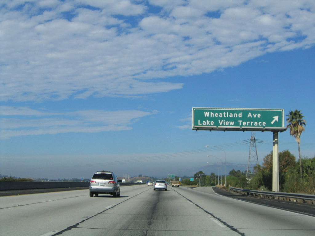
Use Wheatland Avenue north to connect to Foothill Boulevard and Lake View Terrace to the north. Use Wheatland Avenue to reach Hansen Dam Park to the southwest. Photo taken 09/25/05. |
|
Westbound Interstate 210 (Foothill Freeway) reaches Exit 9, Wheatland Avenue to Foothill Boulevard and the community of Lake View Terrace. Photo taken 09/25/05. |
|
A 500kV Los Angeles Department of Water and Power powerline crosses over Interstate 210 at this point. This line is one of three single-circuit 500KV lines owned by LADWP that connect from the High Desert (Victorville substation) to the city of Los Angeles. The other two 500kV LADWP lines pass over Interstate 210 at the interchange with Interstate 5 in Sylmar. Photo taken 09/25/05. |
|
The next three exits along Interstate 210 (Foothill Freeway) west are Exit 8, Osborne Street; Exit 6B, California 118 (Ronald Reagan Freeway) west; and Exit 6A, Paxton Street. Photo taken 09/25/05. |
|
Exit 8 connects directly to Foothill Boulevard, and motorists must take Foothill Boulevard southwest to link with Osborne Street en route to Whiteman Airpark, Interstate 5 near Arleta, and Panorama City. Photo taken 09/25/05. |
|
To reach the main section of Hansen Dam Park, use Exit 8, then follow the signs into the park. The dam and golf course are situated on the south side of the park, and the reservoir is known as Hansen Lake. Photo taken 09/25/05. |
|
Westbound Interstate 210 reaches Exit 8, Foothill Boulevard to Osborne Street. Photo taken 09/25/05. |
|
The next three exits along Interstate 210 (Foothill Freeway) west are Exit 6B, California 118 (Ronald Reagan Freeway) west; Exit 6A, Paxton Street; and Exit 5, Maclay Street. Photo taken 09/25/05. |
|
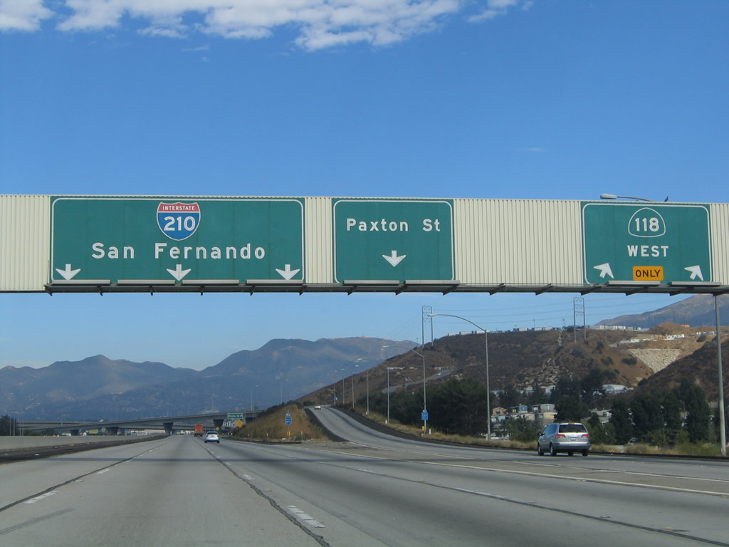
Use the left three lanes to remain on Interstate 210; the right lane exits only to Exit 6B, California 118 (Ronald Reagan Freeway) west. California 118 takes over where Interstate 210 leaves off; it continues west into the Simi Valley, and it ultimately reconnects to U.S. 101 either via the California 23 (Moorpark Freeway) or California 126 (Santa Paula Freeway). Either way, Interstate 210 continues northwest toward its western terminus at Interstate 5 in Sylmar. Photo taken 09/25/05. |
|
The right two lanes of Interstate 210 west will connect to Exit 6B, California 118 west to Simi Valley and Fillmore. California 118 was renamed as the Ronald Reagan Freeway; it used to be called the Simi Valley Freeway. The freeway gained some notoriety in October 2003, when wildfires singed portions of California 118 between the San Fernando Valley and Simi Valley over Santa Susana Pass. Photo taken 09/25/05. |
|
The 220kV Southern California Edison power line continues to parallel Interstate 210, although it takes a high road to pass by the California 118 interchange. Photo taken 09/29/07. |
|
Westbound Interstate 210 (Foothill Freeway) reaches Exit 6B, Interstate 210. The next exit is Exit 6A, Paxton Street. California 118 reaches its end with a complete freeway to freeway interchange; no remnant ramps connect to local streets to the northeast of this interchange. Photo taken 09/25/05. |
|
|
|
|
| This series of photos follows the two-lane transition ramp from Interstate 210 west to California 118 west. This interchange marks the eastern terminus of California 118. A very busy freeway continues west from here across the northern San Fernando Valley toward Santa Susana Pass and Simi Valley. Photos taken 09/29/07. |
|
While still within the footprint of the 210-118 interchange, westbound Interstate 210 (Foothill Freeway) meets Exit 6A, Paxton Street, which parallels California 118 to the southwest from here. Photo taken 09/25/05. |
|
Sweeping ramps carry traffic between Interstate 210 and California 118 at this interchange. Photo taken 09/25/05. |
|
This Interstate 210 west reassurance shield is posted after traffic from the California 118 west transition ramp merges onto the Foothill Freeway westbound. Photo taken 07/04/07. |
|
The next three exits along Interstate 210 (Foothill Freeway) west are Exit 5, Maclay Street; Exit 4, Hubbard Street; and Exit 3, Polk Street. Photo taken 07/04/07. |
|
This Interstate 210 button copy shield is pasted onto a small green sign, and it acts as a reassurance shield after the Paxton Street on-ramp. Photo taken 07/04/07. |
|
Use Maclay Street southwest to enter the city of San Fernando. In spite of the fact that the control city for westbound Interstate 210 is San Fernando as it travels northwest out of Pasadena, Interstate 210 never enters the city of San Fernando. Photo taken 07/15/09. |
|
Westbound Interstate 210 (Foothill Freeway) reaches Exit 5, Maclay Street (which becomes Maclay Avenue within the city limits of San Fernando southwest of here). Interstate 210 skirts the northwestern edge of the city of San Fernando, which is known as the "First City of the Valley" as it was the first to incorporate within the sprawling San Fernando Valley. San Fernando had a population of 23,564 and was incorporated on August 31, 1911. Photo taken 07/15/09. |
|
Four of the final six exits from Interstate 210 west serve the community of Sylmar (part of the city of Los Angeles): Exit 4, Hubbard Street; Exit 3, Polk Street; Exit 2, Roxford Street; and Exit 1C, Yarnell Street. Photo taken 07/04/07. |
|
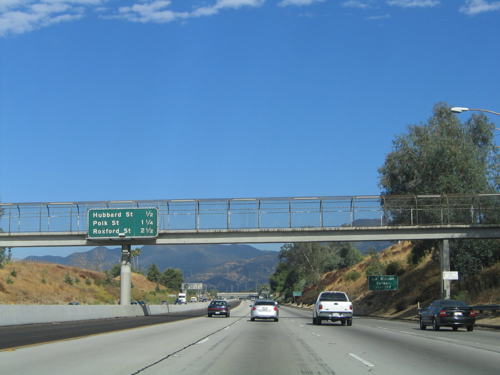
This mileage sign provides the distance to the next three exits along Interstate 210 west: Exit 4, Hubbard Street; Exit 3, Polk Street; and Exit 2, Roxford Street. Photo taken 07/04/07. |
|
Westbound Interstate 210 (Foothill Freeway) meets Exit 4, Hubbard Street, which also leads southwest into the city of San Fernando. Photo taken 09/25/05. |
|
The next exit along Interstate 210 west is Exit 3, Polk Street. Photo taken 09/25/05. |
|
The next three exits along Interstate 210 (Foothill Freeway) west are Exit 3, Polk Street; Exit 2, Roxford Street; and Exit 1C, Yarnell Street. Photo taken 09/25/05. |
|
Due to the planned link with Interstate 710 that remains unbuilt, Caltrans assumes that a good number of motorists are through traffic headed to parts outside of the Los Angeles Basin. To that end, this mileage sign provides the distance to Santa Clarita (10 miles), Bakersfield (89 miles), and Sacramento (365 miles) via Interstate 5 north and California 99 north (for Bakersfield). Photo taken 09/25/05. |
|
An arced pedestrian bridge spans over the Foothill Freeway. Photo taken 07/04/07. |
|
Westbound Interstate 210 (Foothill Freeway) reaches Exit 3, Polk Street. Photo taken 07/04/07. |
|
The next exit along Interstate 210 (Foothill Freeway) west is Exit 2, Roxford Street. Use Roxford Street to travel southwest into the Sylmar community of the city of Los Angeles. Photo taken 07/04/07. |
|
The final three interchanges along Interstate 210 (Foothill Freeway) west are Exit 2, Roxford Street; Exit 1C, Yarnell Street; and Exit 1B-A, Interstate 5 (Golden State Freeway). Photo taken 09/25/05. |
|
Next up on westbound is Exit 2, Roxford Street, next right. Note that Interstate 210 is only three lanes wide in each direction for the final several miles. Photo taken 09/25/05. |
|
Westbound Interstate 210 (Foothill Freeway) reaches Exit 2, Roxford Street. Photo taken 09/25/05. |
|
The next exit along Interstate 210 (Foothill Freeway) west is Exit 1C, Yarnell Street. This is the final non-freeway off-ramp from Interstate 210 west. Photo taken 09/25/05. |
|
An Interstate 210 west reassurance shield assembly is posted after the on-ramp from Roxford Street. Photo taken 09/25/05. |
|
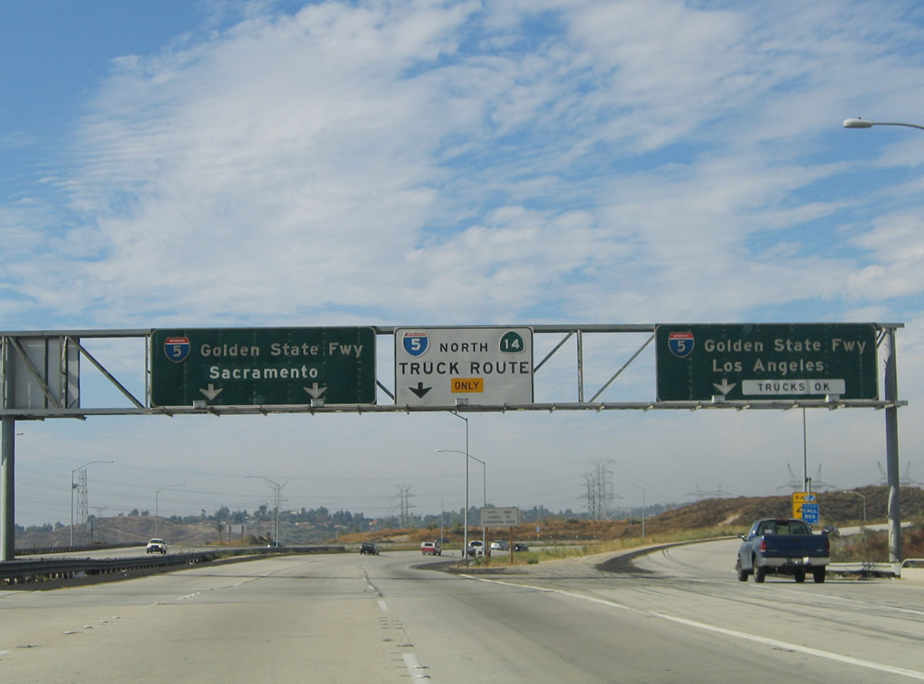
This final interchange sequence sign provides the distance to Exit 1C, Yarnell Street; Exits 1B-A, Interstate 5 south to Los Angeles and north to California 14 (Antelope Valley Freeway) and Bakersfield, San Francisco, and Sacramento. Photo taken 09/25/05. |
|
Westbound Interstate 210 (Foothill Freeway) reaches Exit 1C, Yarnell Street; Interstate 210 prepares to be absorbed into Interstate 5 (Golden State Freeway). Southbound Interstate 5 traffic should use the right lane, and northbound trucks should also use the right lane. Photo taken 09/25/05. |
|
An exit-only off-ramp is created by the on-ramp from Yarnell Street. This off-ramp serves as the transition from westbound Interstate 210 to Exit 1B, Interstate 5 (Golden State Freeway) south. Photo taken 09/25/05. |
|
This newer sign advises southbound traffic to remain in the right lane. A confluence of Los Angeles Department of Water and Power lines all converge near the Sylmar interchange between Interstate 5, California 14, and Interstate 210; several of them come into view in the distance. Photo taken 09/25/05. |
|
Stay left to follow Interstate 5 north to Santa Clarita (which includes Valencia and Newhall). Photo taken 09/25/05. |
|
An end Interstate 210 shield is posted along westbound Interstate 210 just prior to the Interstate 5 interchange. Photo taken 09/25/05. |
|
The left three lanes exit only to Exit 1A, Interstate 5 (Golden State Freeway) north and California 14 (Antelope Valley Freeway) north. The right lane departs to Exit 1B to join with Interstate 5 (Golden State Freeway) south. Trucks should use the number three lane to travel north on Interstate 5 via the truck bypass; cars should stay left to use the main lanes through the Interstate 5-California 14 interchange. This marks the western terminus of Interstate 210. Photo taken 09/25/05. |
|
|
|
|
|
| This series of pictures follows the transition ramp from Interstate 210 west to Interstate 5 north. Cars should stay left, and trucks must stay right to use the Truck Bypass. The split between car and truck lanes occurs just prior to the point where traffic from Interstate 210 west joins Interstate 5 north. The difference in traffic volumes between Interstate 210 and Interstate 5 is dramatic, as evidenced by these pictures. Interstate 210 auto lanes merge left into a very thick traffic situation on Interstate 5. The truck bypass also has traffic on it, although it is not visible from this vantage point. Photos taken 07/15/09 and 09/25/05. |
Page Updated November 5, 2011.