| California 84 east |
|
After leaving the U.S. 101 (Bayshore Freeway) and Marsh Road interchange (Exit 406), California 84 (Marsh Road) approaches the Bayfront Expressway at the next traffic signal. The first right turn connects to Independence Drive; the traffic signal is with Haven Avenue and Bayfront Expressway. California 84 enters the city of Menlo Park. Incorporated in November 1927, Menlo Park is home to 30,648 people and is situated between San Francisco and San Jose. Photo taken 06/29/06. |
|
Northbound Marsh Road ends at this traffic signal. Turn left to Haven Avenue west to Redwood City (frontage road for U.S. 101 (Bayshore Freeway)). At this point, California 84 turns right onto Bayfront Expressway east. Photo taken 06/29/06. |
|
Eastbound California 84 (Bayfront Expressway) begins as a six-lane at-grade expressway. It will follow the bayfront from here to the Dumbarton Bridge approach. While not a freeway, this is a high-speed, access controlled route. Traffic signals exist for Chrysler Drive and Chilco Street before California 84 meets California 114 (Willow Road). Photo taken 06/29/06. |
|
The first traffic signal on California 84 (Bayfront Expressway) east is with Chrysler Drive, which travels south to East Menlo. A PG&E power line parallels California 84 (Bayfront Expressway) along this corridor. Salt evaporation ponds line the bayfront, which is sometimes visible from the eastbound lanes of the expressway. Photo taken 06/29/06. |
|
The speed limit along the expressway is 50 miles per hour, owing in part to the traffic signals. Photo taken 06/29/06. |
|
The next traffic signal on California 84 (Bayfront Expressway) east is with Chilco Street, which travels south to East Menlo, then crosses the railroad tracks into the neighborhoods of Menlo Park. Photo taken 06/29/06. |
|
Reaching Chilco Street, the salt evaporation ponds and the bay come into view. California 84 (Bayfront Expressway) continues east as a six-lane divided expressway. Photo taken 06/29/06. |
|
The six-lane expressway continues east with an almost freeway-like feel. Photo taken 06/29/06. |
|
The next traffic signal on California 84 (Bayfront Expressway) east is California 114 (Willow Road) south to U.S. 101 (Bayshore Freeway) in Menlo Park. Photo taken 06/29/06. |
|
California 114 north is signed as California 84 east, and California 114 south is signed as California 84 west, even though it's not! This sign is indicative of this incorrect signage, which makes the area rather confusing. California 109 (University Avenue) is also signed as California 84, which further adds to the confusion. However, it does assist getting motorists to the Dumbarton Bridge, which is most definitely California 84. Photo taken 06/29/06. |
|
Eastbound California 84 (Bayfront Expressway) meets California 114 (Willow Road) south at this signalized intersection. Continue straight ahead to the Dumbarton Bridge en route to Fremont. The PG&E power line makes a turn to the south at this point. Photo taken 06/29/06. |
|
The fourth and final traffic signal on California 84 (Bayfront Expressway) east is California 109 (University Avenue) south to East Palo Alto and U.S. 101 (Bayshore Freeway) south. California 84 will turn a bit to the northeast to prepare to cross the bay. Photo taken 06/29/06. |
|
Eastbound California 84 (Bayfront Expressway) meets California 109 (University Avenue) at this intersection. California 109 is a short north-south route that is signed as California 84 along northbound California 109. It is unsigned southbound. Photo taken 06/29/06. |
|
A California 84 (Bayfront Expressway) east reassurance shield is posted after the California 109 (University Avenue) intersection. The Dumbarton Bridge finally comes into view as the highway swings a bit to the northeast. Photo taken 06/29/06. |
|
A sign advises motorists that California 84 will soon be crossing the toll Dumbarton Bridge in one-half mile. However, no toll is charged in the eastbound direction. Westbound motorists must pay the toll. Photo taken 06/29/06. |
|
Prior to crossing the bridge, a turnoff for the Ravenswood Open Space Preserve and Don Edwards San Francisco Bay National Wildlife Preserve is provided from the eastbound lanes. For views of the Dumbarton Bridge and the bay environment, exit here. Photo taken 06/29/06. |
|
At the intersection with the access road to the wildlife refuge, another toll crossing entrance sign is posted. California 84 continues east onto the Dumbarton Bridge approach. Photo taken 06/29/06. |
|
Another California 84 east reassurance shield is posted shortly thereafter. The access road to the open space preserve and the wildlife refuge closely parallels California 84; a parking area is located near the foot of the bridge. Photo taken 06/29/06. |
| California 84 - Dumbarton Bridge east |
|
The shortest of the bridges to span the San Francisco Bay, the Dumbarton Bridge carries California 84 from Menlo Park east to Fremont. The expressway upgrades to a freeway configuration. Six lanes cross the bridge, with three lanes in each direction. The bridge is 1.63 miles (8,600 feet) long and is relatively new, having opened in October 1982. It replaces a much older span, which was the first bridge to cross the bay. The original Dumbarton Bridge opened to traffic on January 17, 1927, and the state purchased the bridge in 1951.1 Remnants of this original bridge remain close to the abandoned railroad bridge that can be seen to the south of the modern Dumbarton Bridge. Photo taken 06/29/06. |
|
Tall Pacific Gas and Electric (PG&E) power lines again follow California 84, this time on the north side of the Dumbarton Bridge. Photo taken 06/29/06. |
|
Despite the lack of shoulders on the high-rise portion of the Dumbarton Bridge, bicycle lanes with jersey barrier separators are located on both sides of the bridge. At the highest point, the Dumbarton Bridge clearance is 85 feet above the mean tide line. Photo taken 06/29/06. |
|
The hills of the Walpert Ridge (including Day Creek Pioneer Regional Park and Garin Regional Park) come into view as California 84 crosses the southernmost portion of San Francisco Bay. Photo taken 06/29/06. |
|
Leaving San Mateo County for the first time since its inception on the coast, California 84 enters Alameda County and the city of Fremont. Incorporated on January 23, 1956, the city encompasses five communities: Centerville, Irvington, Mission San Jose, Niles, and Warm Springs. The population of the city as of the 2000 Census was 203,413; by 2005, it had grown to 210,158. Photo taken 06/29/06. |
|
The high rise section ends, and California 84 now follows a causeway from here east back to the mainland. Dumbarton Point, the geographical feature for which the bridge is named, can be seen to the southeast of the bridge. Coyote Hills Regional Park looms near the eastern edge of the bay. Photo taken 06/29/06. |
|
A variety of transmission towers are located near the east end of the Dumbarton Bridge. Photo taken 06/29/06. |
|
A bikeway parallels the California 84 freeway as it travels east through Don Edwards San Francisco Bay National Wildlife Refuge. Photo taken 06/29/06. |
|
KGO News Talk 810 transmits its signal from a tower located on the north side of California 84/Dumbarton Bridge. The California 84 freeway continues east on the Dumbarton Bridge causeway, with six lanes in each direction. Photo taken 06/29/06. |
| California 84 east |
|
Continuing east, the toll plaza for westbound traffic comes into view; however, eastbound travelers do not have to pay. The first exit in Fremont is Exit 36, Thornton Avenue south to Newark and Paseo Padre Parkway northeast to Union City and western Fremont. Photo taken 06/29/06. |
|
Use Exit 36 to the Don Edwards San Francisco Bay National Wildlife Refuge via Thornton Avenue south to Marshlands Road west. To the north, Coyote Hills Regional Park can be reached via Paseo Padre Parkway north. Photo taken 06/29/06. |
|
Eastbound California 84 reaches Exit 36, Thornton Avenue south to Newark and Paseo Padre Parkway northeast to Union City and western Fremont. Photo taken 06/29/06. |
|
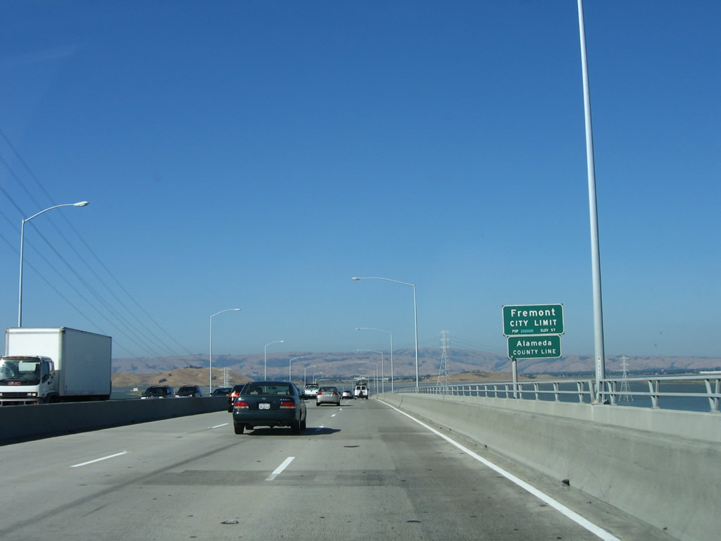
The next exit on California 84 east is Exit 37, Newark Boulevard south to Newark and Ardenwood Boulevard north to western Fremont and Union City. From the Thornton Avenue/Paseo Padre Parkway overpass east to Interstate 880, California 84 serves as the city limits between Fremont to the north and Newark to the south. The city of Newark is surrounded by Fremont on all sides (the city was incorporated in September 1955, thus avoiding incorporation with the much larger Fremont, which incorporated in January 1956). Newark incorporated separately in order to avoid becoming an industrial zone, which was discussed during the initial discussions to create the city of Fremont. As of the 2000 Census, Newark is home to 42,471 people. Photo taken 06/29/06. |
|
A California 84 reassurance shield is posted after the on-ramp from Exit 36, Thornton Avenue/Paseo Padre Parkway. Photo taken 06/29/06. |
|
Eastbound California 84 reaches Exit 37, Newark Boulevard south to Newark and Ardenwood Boulevard north to western Fremont and Union City. There is no auxiliary lane for this exit. Photo taken 06/29/06. |
|
The next exit on California 84 east is Exit 38, Interstate 880 (Nimitz Freeway) north and Decoto Road. Riveted overlay panels on this sign for Interstate 880 cover the original designation of California 17. Photo taken 06/29/06. |
|
California 84 east will transition onto Interstate 880 (Nimitz Freeway) south briefly, then turn east again via Thornton Avenue. Use the right lane for the continuation of California 84. Use the left two lanes to connect to Interstate 880 (Nimitz Freeway) north to Hayward and Oakland. In addition, this left exit will connect to Decoto Road, which travels northeast to the Decoto neighborhood of Union City. Photo taken 06/29/06. |
|
Eastbound California 84 reaches Exit 38, Interstate 880 north and Decoto Road (left exit). The right lane becomes exit only for the continuation of California 84 east via Interstate 880 south. Photo taken 06/29/06. |
| Interstate 880 south & California 84 east |
|
After the Interstate 880 / California 84 interchange, this reassurance shield assembly for Interstate 880 south and California 84 east is posted. The two routes share an alignment for only two miles; they split at the next interchange (Exit 21, Thornton Avenue). Photo taken 06/29/06. |
|
Southbound Interstate 880 and eastbound California 84 split at Exit 19, Thornton Avenue. From here, California 84 will navigate central Fremont via Thornton Avenue northeast, then turn southeast on Fremont Boulevard, then turn east on Peralta Boulevard to Mowry Avenue. To the west, Thornton Avenue is a local street that serves the city of Newark. Between Exit 21 (California 84 west) and Exit 16 (Stevenson Boulevard), Interstate 880 forms the city limits boundary between Newark and Fremont. Photo taken 06/29/06. |
| California 84 east |
|
After exiting from Interstate 880 (Nimitz Freeway), California 84 follows Thornton Avenue. This is the first road in a series of city streets California 84 follows through the city of Fremont. But first, upon crossing over Interstate 880 at Exit 19, motorists have a chance to exit onto Interstate 880 north and California 84 west via a loop ramp. Photo taken 06/29/06. |
|
The first reassurance shield for California 84 east on Thornton Avenue is posted at the final Interstate 880 traffic signal near Blacow Road and Dutra Way. Photo taken 06/29/06. |
|
Parts of California 84 feel almost like an expressway with a four-lane configuration. The next traffic signal is with Cabrillo Drive, which also connects to a park and ride on the northwest side of California 84. Photo taken 06/29/06. |
|
Eastbound California 84 approaches Dusterberry Way. The post office is located at this intersection. California 84 will turn southeast on Fremont Boulevard about five blocks after Dusterberry Way. Photo taken 06/29/06. |
|
The intersection with Oak Street, which has an advance sign, is three blocks prior to Fremont Boulevard. Photo taken 06/29/06. |
|
California 84 will depart Thornton Avenue and turn right (southeast) onto Fremont Boulevard. However, California 84 only follows Fremont Boulevard for a short distance, then turns left (east) on Peralta Boulevard. Photo taken 06/29/06. |
|
After turning southeast on Fremont Boulevard, a trailblazer advises that California 84 will turn east again onto Peralta Boulevard. Through traffic on the state highway should use the left lane. Photo taken 06/29/06. |
|
At this traffic signal, eastbound California 84 leaves Fremont Boulevard and turns east on Peralta Boulevard. The Amtrak Station is located at this intersection. Photo taken 06/29/06. |
|
A reassurance shield for California 84 is posted shortly after the transition from Fremont Boulevard. Photo taken 06/29/06. |
|
The next major intersection along eastbound California 84 (Peralta Boulevard) is with Sequoia Road north to Paseo Padre Parkway. California 84 briefly narrows to two lanes through this residential area. Photo taken 06/29/06. |
|
Shortly thereafter, eastbound California 84 (Peralta Boulevard) meets Paseo Padre Parkway itself. Photo taken 06/29/06. |
|
The Bay Area Rapid Transit (BART) passes over California 84 (Peralta Boulevard). The BART travels north to Hayward, Oakland, and San Francisco. The Fremont BART Station is located south of here - follow California 84 east to Mowry Avenue southwest to the station. Photo taken 06/29/06. |
|
A few blocks west of the BART overpass, California 84 approaches Mowry Avenue. California 84 will turn east onto Mowry Avenue. Use Mowry Avenue west to the BART Station and the Fremont Civic Center. Photo taken 06/29/06. |
|
Both lanes of Peralta Boulevard turn onto Mowry Avenue east. Photo taken 06/29/06. |
|
A reassurance shield for California 84 is posted shortly on eastbound Mowry Avenue after the transition from Peralta Boulevard. Photo taken 06/29/06. |
|
Eastbound California 84 (Mowry Avenue) meets Guardino Drive at this traffic signal. Use Guardino Drive south to Fremont Central Park and Lake Elizabeth. Photo taken 06/29/06. |
|
Eastbound California 84 (Mowry Avenue) meets Cherry Lane at this traffic signal, shortly after the Guardino Drive traffic signal. Photo taken 06/29/06. |
|
At Overacker Avenue, eastbound California 84 (Mowry Avenue) turns a bit to the north and prepares to pass under the Union Pacific Railroad tracks. Photo taken 06/29/06. |
| California 84 east & 238 north |
|
Combining with SR 238 (Mission Boulevard) north, SR 84 east crosses Alameda Creek after the Mowry Avenue intersection. SR 84 turns east again at Niles Canyon Road. Photo taken 06/29/06. |
|
California 84 turns east onto Niles Canyon Road at this intersection, while California 238 continues north along Mission Boulevard through Fremont to Union City and Hayward. In Hayward, California 238 transforms into Interstate 238, which connects Interstate 580 and Interstate 880 near San Leandro. Photo taken 06/29/06. |
| California 84 east |
|
Now traveling east on Niles Canyon Road, California 84 will follow this route through Niles Canyon to Sunol and the junction with Interstate 680. An old alignment of California 84 is still in use through parts of Niles Canyon. The first segment of the old road is called Old Canyon Road and features an old bridge. Turn right here to see the old bridge and the beginnings of the old alignment of California 84. Photo taken 06/29/06. |
|
A mileage sign along eastbound California 84 (Niles Canyon Road) provides the distance to Sunol (six miles) and Livermore (17 miles). Photo taken 06/29/06. |
|
The railroad tracks cross over California 84 (Niles Canyon Road) and Alameda Creek on a steel truss bridge. Photo taken 06/29/06. |
|
Shortly thereafter, the railroad tracks again cross over California 84 (Niles Canyon Road), this time on a steel deck girder bridge. Photo taken 06/29/06. |
|
California 84 (Niles Canyon Road) stays close to the edge of Alameda Creek after the second railroad bridge. Both the Union Pacific and Southern Pacific offered rail service through Niles Canyon until 1984; the Pacific Locomotive Association now runs tourist steam trains along the former Southern Pacific right of way between Fremont (Niles) and Sunol. Photo taken 06/29/06. |
|
Eastbound California 84 (Niles Canyon Road) crosses over Alameda Creek on this bridge. Photo taken 06/29/06. |
|
Keeping with the theme, California 84 (Niles Canyon Road) again crosses Alameda Creek on this bridge. Photo taken 06/29/06. |
|
A warning sign for the height of an overpass is the first advance sign for the pending Sunol interchange. California 84 will meet with Main Street, which travels into downtown Sunol. The state route bypasses Sunol for a direct connection to Interstate 680 via Paloma Road. Photo taken 06/29/06. |
|
Eastbound California 84 (Niles Canyon Road) reaches the Main Street exit to Sunol. The state route bypasses Sunol for a direct connection to Interstate 680 via Paloma Road. Photo taken 06/29/06. |
|
This directional interchange offers a right exit to Main Street, which serves unincorporated Sunol. The community of Sunol is located on the north side of California 84 and is home to 1,332 people as of the 2000 Census. Photo taken 06/29/06. |
|
Passing under the transition ramp from westbound California 84 to Main Street, this overpass is indicative of how freeway structures were built in the early 1940s. A date stamp on the right side of the bridge support states this bridge was built in 1941. Caltrans calls this the "Silver Springs Underpass." Photo taken 06/29/06. |
Page Updated September 23, 2007.