| Interstate 80 and U.S. 30 (Lincoln Highway) west |
|
The pavement changes as Interstate 80 leaves the Cornhusker State of Nebraska and enters the Equality State of Wyoming at Milepost 402.78. Photo taken 09/05/04. |
|
Use Exit 401 (Junction Business Loop I-80, Business U.S. 30, and Wyoming 215) to reach the Texas Trail Museum and Bluffs Recreation and Wildlife Area. The Texas Trail Museum features Old West artifacts and provides a history of the eastern Laramie County. The museum is located at 201 W. Third Street in Pine Bluffs; follow the business route north via Parsons Street and the Old Lincoln Highway; turn right onto Third Street. Admission to the museum is free. Photo taken 09/05/04. |
|
In addition to serving the business loop into Pine Bluffs, Exit 401 also connects to Wyoming 215, Albin Road. Follow Wyoming 215 north to Albin (where Wyoming 215 meets Wyoming 216) and to La Grange in Goshen County. Wyoming 215 ends at Wyoming 151 in La Grange. A spur of the Union Pacific Railroad travels north from west of Pine Bluffs north to La Grange and Torrington generally via the Wyoming 215 and U.S. 85 corridors. Photo taken 09/05/04. |
|
The welcome sign to Wyoming is located immediately after the Wyoming 215 trailblazer sign. Note that at the time this picture was taken, there was no slogan (such as, "Forever West" or "Cowboy Up" or "Like No Other Place on Earth") beneath the state's symbol of a bucking bronco and cowboy rider. The design of this version of the state welcome sign is very similar to the license plates that feature Devils Tower used in the 2000s. This entry sign has since changed several times. Photo taken 09/05/04. |
|
The information center at Pine Bluffs is only open between May and October each year. During the winter, a year-round information center is located in Cheyenne off of Interstate 25 (at Exit 4, High Plains Road). Photo taken 09/05/04. |
|
Although services were becoming more and more sporadic in Nebraska, that trend will become more and more common in Wyoming. While services are generally available at most exits between Pine Bluffs and Cheyenne, there are only three exits between Pine Bluffs and Archer: Exit 391, Egbert; Exit 386, Burns/Carpenter; and Exit 377, Hillsdale. So, the next services along westbound is 24 miles west of Pine Bluffs, at Exit 386. Photo taken 09/05/04. |
|
The rest area/tourist information center is located on the south side of the freeway, and it is accessible by both directions of traffic. Unlike most rest areas in Nebraska, which have a unique rest area on each side of the freeway, the rest areas in Wyoming are generally situated at regular exits so that one facility can be used by either direction of traffic. There are only a few exceptions to this general rule. Photo taken 09/05/04. |
|
Westbound Interstate 80 and U.S. 30 reach Exit 401, Junction Business Loop I-80, Business U.S. 30, and Wyoming 215 (Parsons Street) north to Pine Bluffs. The business loop and Business U.S. 30 travel east back into Nebraska to rejoin U.S. 30 at the Nebraska Link 53B intersection and Interstate 80 at Exit 1. Wyoming 215 travels north to Albin and La Grange from Pine Bluffs. Photo taken 09/05/04. |
|
At the base of the offramp, Business Loop I-80, Business U.S. 30, and Wyoming 215 all turn right onto Parsons Street. To north Wyoming 215, turn left at the first intersection (Eighth Street) along Parsons Street. The business loop connects with Old Lincoln Highway at the north end of Parsons Street in the shadow of a large grain elevator. Old Lincoln Highway follows the Union Pacific Railroad closely through Pine Bluffs, then crosses the railroad and travels west on "Old Pine Bluffs Highway" along Laramie County Route 212. The old highway is a mixture of paved and unpaved sections; it passes through Egbert, jogs north to Burns and Hillsdale via Laramie County Routes 213 and 214, and crosses the railroad at Durham. From there, the old road turns southwest along the northside of the railroad to rejoin U.S. 30 at Dell Range Road near Archer. Photo taken 09/05/04. |
|
Back on the mainline, this mileage sign provides the distance to Cheyenne and Rawlins. Rawlins is a significant milestone for travelers headed toward Yellowstone and Grand Teton National Parks. Omitted from this sign are Laramie and Rock Springs. To the north of the freeway, look for the Pine Bluffs Municipal Airport landing strip and ancillary buildings. Photo taken 09/05/04. |
|
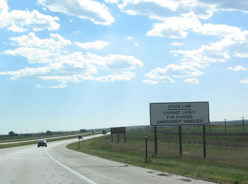
Wyoming state law provides that all vehicles must change lanes on any multi-lane highway when possible if an emergency vehicle is on the shoulder of a road tending to an emergency or writing a ticket. This law is intended to reduce injuries from vehicles that accidentally stray into the shoulder of the road. Photo taken 09/05/04. |
|
Many tourists visiting Wyoming are on their way to the northwestern corner of the state to visit Grand Teton and Yellowstone National Parks. Several options are available to travelers who enter the state on westbound Interstate 80, including following Interstate 80 west to U.S. 287, U.S. 191, U.S. 189, or U.S. 30/U.S. 89 north. Via Interstate 25, a separate array of options are available, including Interstate 25 north to U.S. 20-26 west, U.S. 16 west, or Interstate 90 west to U.S. 14/Alternate U.S. 14 west. Photo taken 09/05/04. |
|
The next exit along westbound Interstate 80 and U.S. 30 is Exit 391, Junction Laramie County Route 154/Egbert Road. Follow Egbert Road north to Egbert. Photo taken 09/05/04. |
|
Westbound Interstate 80/U.S. 30 reaches Exit 391, Junction Laramie County Route 154, Egbert Road. No services are available at this interchange. Photo taken 09/05/04. |
|
After the Egbert interchange, the next mileage sign again provides the distance to Cheyenne, but it also provides the mileage to Laramie for the first time along westbound. Laramie is a featured destination for college students en route to Wyoming's only four-year university, the University of Wyoming. Photo taken 09/05/04. |
|
The next exit along westbound Interstate 80 and U.S. 30 is Exit 386, Wyoming 214/Carpenter Road south to Carpenter and Wyoming 213/Burns Road north to Burns. While Wyoming 214 travels south immediately from this interchange, the connection to Wyoming 213 north is afforded via the Interstate 80 service road on the north side of the freeway. Photo taken 09/05/04. |
|
Westbound Interstate 80 and U.S. 30 reaches Exit 386, Wyoming 214/Carpenter Road south to Carpenter and Wyoming 213/Burns Road north to Burns. Wyoming 213 ends at the town limits of Burns, but Burns Road continues north to meet Old Lincoln Highway near the railroad. Wyoming 214, meanwhile, travels south to Carpenter, ending at Chalk Bluffs Road (Laramie County Route 203). Photo taken 09/05/04. |
|
Once on the ramp, the shields point left (south) for Wyoming 214 and right (north) for Wyoming 213. Photo taken 09/05/04. |
|
Wyoming 213 is a short spur route that turns right here, then immediately turns left onto the service road, then turns north toward Burns. The state highway ends near the railroad within the town of Burns, prior to meeting the old alignment of the Lincoln Highway. Photo taken 09/05/04. |
|
|
|
At the bottom of the offramp, this sign indicates that a left turn follows Wyoming 214 south to Carpenter and a right turn connects to Wyoming 213 north to Burns (via the service road). First photo taken 09/05/04; second two photos taken 08/28/98. |
|
The next exit along westbound Interstate 80 and U.S. 30 is Exit 377, Junction Former Wyoming 217/Reeder Road south to Laramie County Route 207, Arcola Road. To Hillsdale, turn north on Reeder Road and then east on the Interstate 80 Service Road to Laramie County Route 142/Hillsdale Road north. Hillsdale Road enters Hillsdale after crossing the Old Lincoln Highway. Photo taken 09/05/04. |
|
Unlike most other states, truck weigh and inspection stations are called "Port of Entry" in Wyoming and Utah. (They are called "Check Station" in Nevada.) The primary port of entry for westbound Interstate 80 truck traffic is located six miles ahead, just prior to the U.S. 30/Archer interchange at Exit 370. Photo taken 09/05/04. |
|
Westbound Interstate 80 and U.S. 30 reach Exit 377, Junction Former Wyoming 217/Reeder Road south and To Laramie County Route 207/Hillsdale Road north. Wyoming 217 was decommissioned from the state highway system in 2009; this sign has since changed to reflect that fact. Photo taken 09/05/04. |
|
This is the offramp from westbound Interstate 80 and U.S. 30 into the Port of Entry inspection station. All trucks must stop here. Photo taken 09/05/04. |
|
Interstate 80 and U.S. 30 will briefly divide between Exits 370 and 358 so that U.S. 30 can follow Lincolnway through Cheyenne. The town of Archer nowadays has a truck stop and a few buildings, but not much else. U.S. 30 west follows Dell Range Boulevard to Lincolnway before entering the urban limits of Cheyenne. Photo taken 09/05/04. |
|
Westbound Interstate 80 and U.S. 30 split at Exit 370, U.S. 30/Dell Range Boulevard west to Archer and Cheyenne. Photo taken 09/05/04. |
| Interstate 80 west |
|
For the first time since leaving Nebraska, Interstate 80 is signed alone. The Cheyenne Marginal, which follows Interstate 80 to the south of the city center, reconnects with Business Loop I-80 and U.S. 30 at the West Lincolnway interchange. Old U.S. 30 continues west from that point along Wyoming 225, Otto Road. Photo taken 09/07/05. |
|
The next exit along westbound Interstate 80 is Exit 367, Campstool Road. Campstool Road is an east-west, two-lane highway that closely parallels Interstate 80 to the north of the freeway. It eventually transitions into Fifth Street in south Cheyenne. Photo taken 09/07/05. |
|
Owning back to its heritage as a cattle town, the Wyoming Hereford Ranch played a significant role in the development of Cheyenne. Since as early as 1880, ranchers raised purebred Hereford cattle at the Hereford Ranch in Cheyenne. Use Exit 367/Campstool Road to get to the ranch. Photo taken 09/07/05. |
|
Westbound Interstate 80 reaches Exit 367, Campstool Road. A truck stop is located on the north side of this interchange for all services. The freeway continues west toward Cheyenne, which becomes visible on the horizon. Photo taken 09/07/05. |
|
To Curt Gowdy State Park, follow Interstate 80 east to Interstate 25 north (Exit 359). Follow the signs to Happy Jack Road at the Missile Avenue interchange (Exit 10). Photo taken 09/07/05. |
|
Home to 53,010 people as of the 2000 Census, Cheyenne is the largest city in Wyoming. This is a distinction that is commonly challenged by Casper, a comparably sized city northwest of Cheyenne on the banks of the North Platte River. Cheyenne rests on the Crow Creek, which is a smaller river. While at one time Cheyenne's economy was based primarily on cattle and its place on the Texas Trail. Today, Cheyenne's economy is based on the military base (F.E. Warren Air Force Base), state government, transportation of goods via rail and truck, energy, and tourism. An oil refinery dominates the southeastern quadrant of the city, and some commuters live in Cheyenne and travel to jobs in Colorado due to the lower cost of living in Cheyenne than in the Front Range. The next four exits all serve the city of Cheyenne. Photo taken 09/07/05. |
|
The next exit along westbound Interstate 80 is Exit 364, Junction Business Loop I-80 and Wyoming 212 (College Drive to Lincolnway and U.S. 30), one-half mile. This kind of mileage sign is rather rare in Wyoming, simply because there are not many urban areas with closely spaced exits in Wyoming. The next exit for Central Avenue is also Interstate 180 (and Business Loop I-25, U.S. 85, and Business U.S. 87). The following exit is Exit 359A-C for Interstate 25 and U.S. 87. Note that no shields are used in the mileage sign. Behind the sign, note the oil refinery. Photo taken 09/07/05. |
|
Laramie County Community College is a large two year college located on the southeastern corner of WYO 212 (College Drive). Follow Wyoming 212 south to the college. Photo taken 09/07/05. |
|
To reach either of the two hospitals in Cheyenne, follow Interstate 180 north (Exit 362) to Pershing Avenue, then turn east on Pershing Avenue to the UMC Hospital or VA Hospital. Photo taken 09/07/05. |
|
Westbound Interstate 80 reaches Exit 364, Business Loop I-80 and Wyoming 212/College Drive. The business route will follow College Drive north then turn west on Lincolnway. Photo taken 09/07/05. |
|
To the Wyoming state capitol, follow Interstate 80 east to Interstate 180 north. At 24th Street, turn west to the capitol. An alternate route is to take Business Loop I-80 and U.S. 30 east to Capital Avenue north. Photo taken 09/07/05. |
|
An oil refinery dominates the skyline of eastern Cheyenne. The Union Pacific Railroad passes alongside the refinery and its ancillary storage tanks. Photo taken 09/07/05. |
|
Continuing west, Interstate 80 next approaches Exit 362, Interstate 180, Business Loop I-25, U.S. 85, and Business U.S. 87 (Central Avenue). Despite the designation, Interstate 180 is not a freeway; instead, it is an expressway with access control governed by traffic signals and two single span viaducts over the Union Pacific Railroad yards. Use Interstate 180 north to downtown Cheyenne. Business Loop I-25, U.S. 85, and Business U.S. 87 all follow Interstate 180 north into downtown Cheyenne via Central Avenue, which changes into Warren Avenue north of Lincolnway. These three routes angle northwest to rejoin Interstate 25 at Exit 12. Photo taken 09/07/05. |
|
Use Interstate 180, Business Loop I-25 and U.S. 85-87B north to the central business district of Cheyenne. The city of Cheyenne, the "Magic City of the Plains," was founded in 1867 when surveyors from the Union Pacific Railroad constructed the transcontinental railroad. The original downtown area was laid out by General Grenville Dodge so that the city could maximize its exposure to sunlight, especially during the cold winter months. At the time the city was founded, it was part of the Dakota Territory. Once the state of Wyoming was born in 1890, Cheyenne became the nascent state's capital. Photo taken 09/07/05. |
|
To Frontier Park, county fairgrounds, and Old West Museum, follow Interstate 180/Central Avenue north. Cheyenne is well known for the annual Frontier Days celebration, which occurs every July at Frontier Park. This event is known as the "Daddy of 'Em All" cowboy rodeo. Photo taken 09/07/05. |
|
Westbound Interstate 80 reaches Exit 362, Interstate 180, Business Loop I-25, U.S. 85, and Business U.S. 87/Central Avenue north to downtown Cheyenne and Business Loop I-25, U.S. 85, and Business U.S. 87 south to Greeley. Photo taken 09/07/05. |
|
Since the interchange between Interstate 80 and Interstate 180/U.S. 85 is a diamond, traffic signals govern all movements. There is not enough room here to establish a freeway to freeway connection unless houses and/or businesses are removed. Photo taken 09/06/05. |
|
Motorists traveling south on U.S. 85 to Greeley should prepare to turn left at the upcoming traffic signal; all traffic for northbound Interstate 180, Business Loop I-25, and U.S. 85-87B should prepare to turn right. Photo taken 09/06/05. |
|
|
This is part of the "transition" from one Interstate highway to another, and it is interrupted by a traffic light. In fact, this interchange is not even a cloverleaf, which at least would have allowed unrestricted access from Interstate 80 to northbound Interstate 180. But it does not matter; Interstate 180 is regulated by five traffic signals between here and its northern terminus at Business Loop I-80 and U.S. 30 (Lincolnway) in downtown Cheyenne. Photos taken 09/06/05 and 08/02/10. |
|
This view looks north along Interstate 180, Business Loop I-25, U.S. 85, and Business U.S. 87/Central Avenue north to downtown Cheyenne. Photo taken 09/07/05. |
|
Back on the mainline, an Interstate 80 west reassurance route marker is posted after the Interstate 180 and U.S. 85 interchange. Photo taken 08/02/10. |
|
A pedestrian bridge crosses over Interstate 80. Photo taken 08/02/10. |
|
The next two exits along westbound Interstate 80 are Exits 359A-C, Interstate 25 and U.S. 87 north to Wheatland and Casper and south to Fort Collins and Denver. Photo taken 09/07/05. |
|
A welcome center (visitors information center) is located on Interstate 25/U.S. 87 southbound (Exit 359A). Once on Interstate 25 south, follow the blue signs to Exit 4 (High Plains Road), about four miles south of Interstate 80. Photo taken 09/07/05. |
|
The next exit along westbound Interstate 80 is Exit 359C, Interstate 25 and U.S. 87 north to Wheatland, Douglas, and Casper followed by Exit 359A, Interstate 25 and U.S. 87 south to Fort Collins and Denver. This is a major north-south freeway corridor that connects Cheyenne with Casper (north) and Denver (south), and Interstate 25 offers alternate routes to Northwest Wyoming (Grand Teton and Yellowstone National Parks). Interstate 25 ends at Interstate 90 in Buffalo in Johnson County. Photo taken 09/07/05. |
|
The Burlington Northern and Santa Fe Railroad, which travels north-south along the Interstate 25 corridor in southeastern Wyoming, crosses over Interstate 80. This north-south railroad section does not share the large, east-west railroad yard operated by Union Pacific Railroad, but it is still a major player in the movement of freight and goods through Wyoming. Photo taken 09/07/05. |
|
|
The first ramp in the Interstate 25/Interstate 80 cloverleaf interchange is Exit 359C, Interstate 25/U.S. 87 north to Wheatland, Douglas, and Casper. The second ramp connects to southbound Interstate 25 en route to Denver, Colorado Springs, Pueblo, Santa Fe, Albuquerque, and Las Cruces. Photos taken 08/02/10 and 09/07/05. |
|
A regulatory sign advises that Interstate 80 is closed when the lights above the sign are flashing. Photo taken 08/02/10. |
|
Westbound Interstate 80 reaches Exit 359C, Interstate 25 and U.S. 87 north to Casper. This is the first ramp in this cloverleaf interchange; the loop ramp connects to southbound. Photo taken 09/07/05. |
|
This is the gore point signage for the connection from westbound Interstate 80 to northbound Interstate 25. The Dwight D. Eisenhower Highway, which traverses the country from San Francisco to Washington, D.C., via Interstate 80, Interstate 25, and Interstate 70, joins westbound Interstate 80 after this interchange. Photo taken 09/07/05. |
|
A welcome center is located one mile south of Interstate 80 by taking Interstate 25/U.S. 87 south to the High Plains Road (Exit 4) interchange. This sign indicates that travelers may use Interstate 25 southbound to reach Exit 4, a distance of approximately four miles. Photo taken 09/07/05. |
|
|
Westbound Interstate 80 reaches Exit 359A, Interstate 25/U.S. 87 south to Denver and the Front Range of the Colorado Rockies. The Colorado State Line is only about eight miles south of this interchange. The next interchange is the return of Business Loop I-80/U.S. 30 (Lincolnway) to Interstate 80. In addition, the next exit connects to Wyoming 225/Otto Road westbound. Photos taken 08/02/10 and 09/07/05. |
|
This is the gore point signage for the connection from westbound Interstate 80 to southbound Interstate 25. Photo taken 09/07/05. |
|
Owing to the large distance between cities (Cheyenne and Laramie), there is only one exit with services: Exit 335 in Buford. After that, no services are available until reaching Laramie (Exit 316, Junction Business Loop I-80 and U.S. 30, Grand Avenue). Photo taken 09/07/05. |
|
Westbound Interstate 80 crosses over the Union Pacific Railroad and Lincolnway before reaching the offramp for Exit 358. The ramp to U.S. 30 and Business Loop I-80 eastbound and Wyoming 225 and Otto Road westbound is a loop ramp built in such a way that the railroad could be avoided. Photo taken 09/07/05. |
|
A double-circuit, monopole power line comes into view as Interstate 80 meets Exit 358. U.S. 30 will now join the freeway for the journey over the Laramie Mountains. Photo taken 08/02/10. |
|
This view looks west on Interstate 80 as we pass through the Linconlway interchange. It's all uphill from here to the Happy Jack Road interchange (Exit 323). Photo taken 09/07/05. |
| Interstate 80 and U.S. 30 west |
|
The next exit along Interstate 80 and U.S. 30 west is Exit 357, Wyoming 222/Roundtop Road north to Wyoming 210/Happy Jack Road and south to Wyoming 225/Otto Road. A Wal-Mart distribution center is located just north of this interchange, and wind farms become visible alongside the freeway. Photo taken 10/13/07. |
|
|
Interstate 80 and U.S. 30 are again cosigned as the freeway leaves the Cheyenne metropolitan area. The two routes remain merged until Exit 316 (Junction Business Loop I-80/Grand Avenue in Laramie). Exit 357 did not exist in 2005, so the signage changed significantly between 2005 and 2007. Photos taken 10/13/07 and 09/07/05. |
|
Westbound Interstate 80 and U.S. 30 meet Exit 357, Wyoming 222/Roundtop Road north to Wyoming 210/Happy Jack Road and south to Wyoming 225/Otto Road. Photo taken 10/13/07. |
|
|
Before Exit 357 opened to traffic, this mileage sign used to provide the distance to Laramie (45 miles) and Rock Springs (253 miles). This is the first time Rock Springs appears on a mileage sign on Interstate 80 westbound. Omitted is Rawlins in Carbon County. The 2007 picture shows that the mileage sign is gone and that the milepost now appears in the middle of the Wyoming 222 interchange. Photos taken 10/13/07 and 09/07/05. |
|
These Interstate 80 and U.S. 30 west shields are posted after the onramp from Exit 357, Wyoming 222/Roundtop Road. Photo taken 08/02/10. |
|
During times of severe inclement weather such as dense fog, blowing snow, high winds, or extremely stormy conditions, the freeway may be closed over the summit. Lights would be flashing and this sign would advise motorists of any closures during these events. Traffic should return to Cheyenne when the freeway is closed. Photo taken 10/13/07. |
|
This mileage sign along Interstate 80 and U.S. 30 west provides the distance to Laramie (43 miles) and Rock Springs (251 miles). Photo taken 10/13/07. |
|
Small Buford (PhinDeli) merits its own billboard; it is not too far west of here. Photo taken 08/02/10. |
|
|
|
|
|
| Windswept, wide-open, high-altitude plains spread out in all directions as Interstate 80 travels into the Sherman Mountains. Taller peaks become visible in the distance as the freeway continues to ascend in elevation. A 345kV power line will cross over the freeway ahead. The mountains surrounding Vedauwoo and the Pole Mountain wilderness come into view as Interstate 80 and U.S. 30 continue west. Photos taken 08/02/10, 10/13/07, and 09/07/05. |
|
|
|
|
|
| Interstate 80 and U.S. 30 continue to gain elevation as they continue west. A large wind farm was added to the landscape in the late 2000s. Photos taken 08/02/10 and 10/13/07. |
|
|
The next exit along westbound Interstate 80 is Exit 348, Wyoming 225, Otto Road. Otto Road follows the old alignment of U.S. 30/Lincoln Highway between Exits 358 and 348. Photos taken 08/02/10 and 09/07/05. |
|
Westbound Interstate 80 and U.S. 30 reach Exit 348, Wyoming 225, Otto Road. Photo taken 09/07/05. |
|
After the Otto Road interchange, we find this reassurance shield assembly for Interstate 80 and U.S. 30 westbound. Photo taken 09/07/05. |
|
After the Otto Road interchange, this mileage sign provides the distance to Laramie and Rawlins, which are the next two major cities along Interstate 80 and U.S. 30 westbound. Photo taken 09/07/05. |
|
The next exit along westbound Interstate 80 and U.S. 30 is Exit 345, Warren Road. A large truck parking area is located on the north side of this interchange. Photo taken 10/13/07. |
|
Interstate 80 and U.S. 30 cross over the double track Union Pacific Railroad, a major transportation corridor that spans the entire state of Wyoming on a corridor roughly parallel to Interstate 80. The freeway and railroad cross paths multiple times along the route of Interstate 80; here, the railroad switches from the north side to the south side of the freeway. Photo taken 09/07/05. |
|
An old alignment of U.S. 30 and its former bridge over the railroad is visible just north of the freeway. Photo taken 10/13/07. |
|
Westbound Interstate 80 and U.S. 30 reach Exit 345, Warren Road and its truck parking area. Photo taken 10/13/07. |
|
This reassurance shield assembly for Interstate 80 and U.S. 30 is posted after the Warren Road interchange. The next exit is Exit 342, Wyoming 218/Harriman Road. Photo taken 09/07/05. |
|
|
Now traveling parallel to Interstate 80 and U.S. 30 along the north side of the freeway is the Union Pacific Railroad. Trains are a common sight along this stretch of Interstate 80, and the familiar yellow and black engines of the Union Pacific usually front those trains. Photos taken 10/13/07. |
|
|
The next exit along Interstate 80 and U.S. 30 west is Exit 342, Junction Former Wyoming 218/Harriman Road (one-half mile). Harriman Road travels south from Interstate 80 toward the Colorado state line (portions are unpaved after the former state segment). The first several miles were designated as Wyoming 218 until 2009, when the state-maintained segment was reverted to county maintenance. The 2007 picture shows one of the very first instances of Clearview font to appear in the state of Wyoming. This font is now the preferred design for new and replacement guide signs. Photos taken 10/13/07 and 09/07/05. |
|
Interstate 80 and U.S. 30 lose a bit of elevation before meeting the Harriman Road interchange. Prior to 2003, the Harriman Road interchange was not signed on the advance signs as a state highway. That changed with some sign replacements that occurred between 2003 and 2005. Wyoming 218 only exists for a short distance south of Interstate 80; the highway changes into Laramie County Route 102 prior to reaching Harriman. Photo taken 09/07/05. |
|
|
Prior to 2009, Wyoming 218 was a very short state route, becoming Laramie County Route 102 before reaching Harriman. The Wyoming 218 was covered up at the time it was removed from the state highway system. Photos taken 08/02/10 and 10/13/07. |
|
A red rock cut stands out just prior to Exit 342. Photo taken 10/13/07. |
|
Westbound Interstate 80 and U.S. 30 reach Exit 342, Harriman Road (former Wyoming 218). Harriman Road follows the original route of the Lincoln Highway, which parallels the Union Pacific Railroad en route to Tie Siding and thence onto Laramie. The railroad does not proceed over to Sherman Summit, and it has been realigned south of Interstate 80. This old alignment of Lincoln Highway (via Harriman and Tie Siding) comes very close to the Colorado state line near the site of Harriman. Photo taken 10/13/07. |
|
U.S. 30 and Interstate 80 are again cosigned on the reassurance shield after Exit 342. U.S. 30 is well-signed on nearly every single reassurance shield assembly found on pavement its shares with Interstate 80. Most other states do not sign their braided routes (also known as cosigned routes, routes that share an alignment, or multiplexed routes) nearly as well as Wyoming. Of course we also appreciate the appearance of the state name in the Interstate shields. Enjoy this exceptional level of high quality signage while you can; in Utah, all Interstate shields are neutered and U.S. 189 virtually disappears on its shared alignment with Interstate 80. Photo taken 08/02/10. |
|
The distance to Laramie and Rawlins is provided on the next mileage sign. Laramie is less than a half-hour's drive from here via Interstate 80. Photo taken 09/07/05. |
|
Due to some accidents during the late 1990s and early 2000s, additional safety measures have been implemented along Interstate 80 to ensure a reduced chance of accidents during periods of inclement weather. This sign, along with variable message signs, new lights, and other measures are designed to alleviate these problems. Photo taken 09/07/05. |
|
A vintage section of old Lincoln Highway, now abandoned, can be seen from Interstate 80/U.S. 30 by looking to the northeast from the freeway after the Harriman Road interchange. Photo taken 09/07/05. |
|
The next exit along westbound Interstate 80 and U.S. 30 is Exit 339, Junction Laramie County Route 216/Remount Road (one-quarter mile). This is the last interchange along Interstate 80 in Laramie County. Interestingly, the city of Laramie is not in Laramie County; it is located in Albany County. Photo taken 09/07/05. |
|
Westbound Interstate 80 and U.S. 30 meet Exit 339, Remount Road (Junction Laramie County Route 216). This is the second of two advance guide signs for this interchange; as it typical for rural/less used interchanges in Wyoming, the second guide sign is only the gore point sign. Photo taken 09/07/05. |
|
When this sign is flashing, tune to AM 1610 for information on traffic and weather conditions. Photo taken 09/07/05. |
|
The rocks at Vedauwoo and Pole Mountain come into view as Interstate 80 and U.S. 30 continue their gradual ascent up to Sherman Summit, which is located at Exit 323 (about 14-15 miles ahead). Photo taken 09/07/05. |
|
Interstate 80 and U.S. 30 westbound exit Laramie County and enter Albany County at Milepost 336.61. Photo taken 09/07/05. |
Page Updated September 15, 2014.