Interstate 664 Virginia

Overview
Interstate 664 in Virginia is a western bypass and alternate route for the Virginia Tidewater and the Hampton Roads metropolitan area. I-664 begins with a northerly orientation toward the James River from Bowers Hill in Chesapeake, where the east end of I-64 and west end of I-264 converge. North from Suffolk and Portsmouth, I-664 crosses the Monitor-Merrimac Memorial Bridge Tunnel before entering Newport News and Hampton, where it reunites with I-64.
Interstate 664 utilizes sequential based exit numbers. The route represents the western half of the Hampton Roads Beltway system; the eastern half is Interstate 64. Signs and trailblazers are posted on the beltway using inner and outer directions.
 History
Planning for Interstate 664 began in 196811 and the first contract for work on the route was awarded in 1971.3 The location and design of the bridge-tunnel linking Newport News and Suffolk was approved in 1973, with initial construction starting in 1978.11 The first segment of Interstate 664 was completed from I-64 south to Powhatan Parkway in Hampton on June 25, 1981. This entailed upgrading the previously built Newport News Connector (SR 134). The freeway was further extended another 2.6 miles southwest to Roanoke Avenue in Newport News by December 1983.15
Dredging in Thimble Shoal Channel started on February 18, 1986 for the fill material needed to create the islands for the I-664 bridge-tunnel. 2.25 million cubic yards of material was needed.1 Virginia was awarded $149.7 million in federal highway funds in May 1986 to complete the bridge tunnel system along I-664. The $637 million overall cost for I-664 included $140 million for access roads at Newport News and $100 million for the interchange at Bowers Hill with Interstate 64.2 The $126.25 million contract awarded on August 21, 1986 for the pair of 4,732 foot long tunnels on I-664 was the most expensive single construction contract awarded to date in the state of Virginia.3
A ribbon cutting ceremony held on September 16, 1987 formally opened a 1.5 mile long section of Interstate 664 between 34th Street at Downtown Newport News and Chestnut Avenue (Exit 4) to the north.4 This section was extended southward to 23rd and 26th Streets by January 1988.14 Work on the tunnel system continued to March 31, 1988, when the first of 15 tunnel segments were sunk into place.5 The last of the tubes was laid into place on June 27, 1989.6 The steel tube segments are 80 feet wide and 40 feet deep.5
The 3.1 mile elevated roadway linking the tunnel south entrance with Suffolk was completed by August 1990.7 The December 1991 completion date was pushed back in June 1991 to April 1992 as crews continued to work on the electrical and ventilation systems to March of that year.8
The tunnel system was officially named the Monitor Merrimack Memorial Bridge Tunnel in September 1991 by the Virginia Transportation Board. 1,800 area residents signed a petition to name the crossing after the March 9, 1862 battle between the Union and Confederate ironclads. The two vessels engaged one another about a mile from the crossing.9
A seven mile section of Interstate 664, from Chesapeake north to SR 135 (Exit 8) in Suffolk, opened to traffic following a ribbon cutting ceremony held on January 17, 1992. The freeway cost $139 million.10 This section tied into the bridge-tunnel complex when it opened to traffic at 12:01 AM on April 30, 1992. A formal dedication of the Monitor Merrimack Memorial Bridge Tunnel was held the previous day and led by Gov. L. Douglas Wilder, completing the $400 million crossing.12,13 Interstate 664 was not approved by the American Association of State Highway and Transportation Officials (AASHTO) Special Committee on Route Numbering until June 13, 1992.
Route Information
North End – Newport News, VA
South End – Chesapeake, VA
Mileage – 20.21
Cities – Chesapeake, Suffolk, Hampton, Newport News
- Junctions –


Source: December 31, 2021 Interstate Route Log and Finders List
I-664 Annual Average Daily Traffic (AADT)
Source: 2016 VDOT Traffic Volume

The Newport News Connector formed a controlled access route southwest from I-64 west along what is now I-664 to Aberdeen Road, and along Aberdeen Road to SR 143 (Victoria Boulevard). It was designation SR 134 between 1967 and 1971.
Interstate 664 ended at the split diamond interchange with Chestnut Street from the north until 1987.
Virginia Official Highway Maps showed the southern extent of Interstate 664 as SR 664 through part of the 1980s. The 1986 map was the first to show the proposed alignment south to Bowers Hill.
 Photo Guides
North End  – Newport News, Virginia
![]() North at
North at ![]()
Interstate 664 advances northeast one mile from the diamond interchange (Exit 2) with Powhatan Parkway to Exits 1A/B for I-64. 10/12/14

Sound walls line Interstate 664 ahead of the SR 415 (W Queen Street) underpass. The directional T interchange with I-64 follows over an area of wetlands along Newmarket Creek. 10/12/14

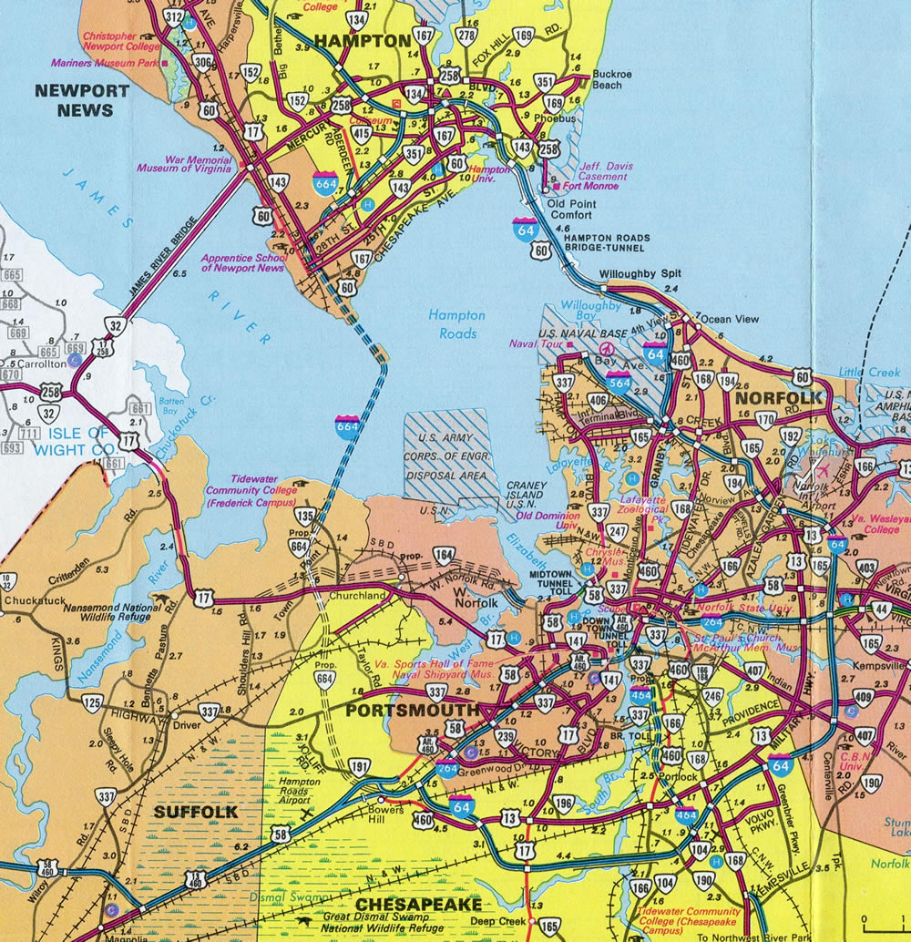
A two lane flyover (Exit 1A) links I-664 north with Interstate 64 west toward Williamsburg and Richmond. Exit 1B references Downtown Hampton in place of I-64. I-64 (Hampton Roads Beltway) arcs southward from Phoebus across the Hampton Roads Bridge Tunnel into Norfolk. 10/12/14
![]() East at
East at ![]()

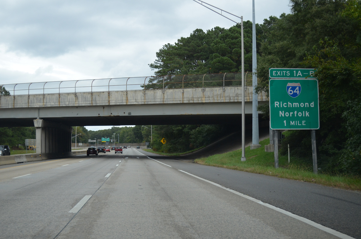
The first sign for Interstate 664 (Exit 264) appears within the exchange joining I-64 east with U.S. 258 (Mercury Boulevard). I-664 is the recommended route for vacationers destined to the North Carolina Outer Banks via the Chesapeake Expressway (SR 168) south. 10/12/14
Eastbound I-64 passes by Hampton Coliseum ahead of the two-lane ramp (Exit 264) for I-664 southwest to Newport News and the Monitor-Merrimac Memorial Bridge Tunnel. 10/12/14

Interstate 64 enters the Hampton Roads Beltway system beyond the directional T interchange (Exit 264) with I-664 south. I-664 reaches Downtown Hampton in 4.5 miles. 10/12/14
![]() West at
West at ![]()

I-64 runs west alongside Newmarket Creek from the exchange with SR 134 (Armistead Avenue) and LaSalle Avenue to Interstate 664 south. 10/12/14

The entrance ramp from SR 134 (Armistead Avenue) forms an auxiliary lane west to Exit 264. Interstate 64 curves through northern reaches of Newport News beyond I-664 while the Hampton Roads Beltway angles southwest toward Suffolk. 10/12/14
 North End Throwback

Posted a half mile south of Interstate 64, this set of signs was replaced in kind by 2011. 03/01

The greenout for Downtown Hampton at the north end of Interstate 664 replaced “I-64 East”. These overheads were carbon copied by 2011. 03/01

This set of signs was replaced by 2007 to show the two-lane off-ramp (Exit 264) for I-664. The La Salle Avenue overhead previously displayed a SR 167 shield. 03/01
South End  – Chesapeake, Virginia
![]() South at
South at ![]()
![]()
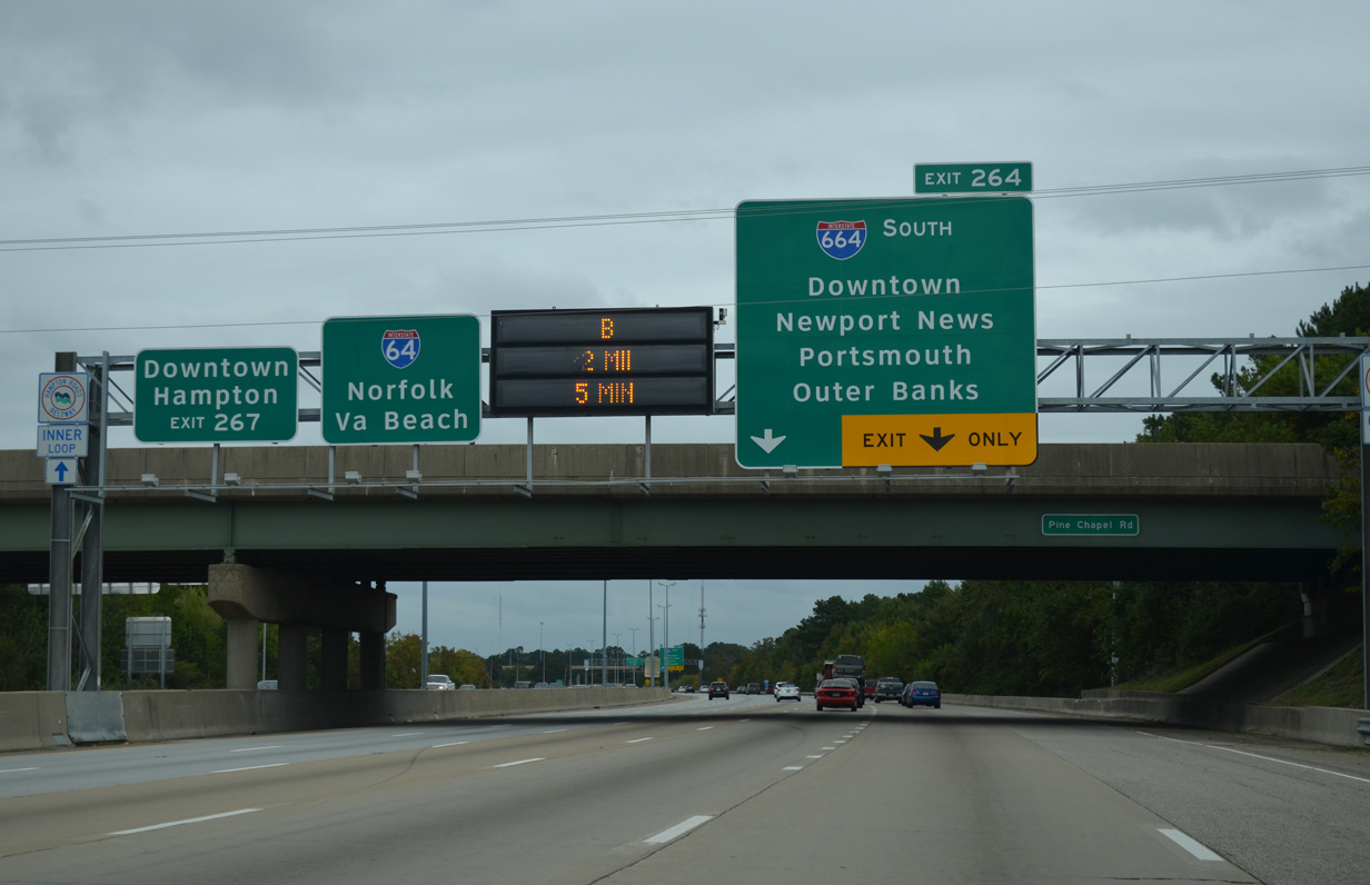
Interstate 664 converges with U.S. 13-58-460 at Bowers Hill just ahead of the three-wye interchange (Exit 15) with I-264 east and I-64 / Hampton Roads Beltway outer loop. 12/14/17

A three lane entrance ramp merges onto I-664 south from U.S. 13-58-360 east of Suffolk. The southbound roadway expands to four lanes across a CSX Railroad line ahead of the I-64/264 split at Exit 15. 12/14/17
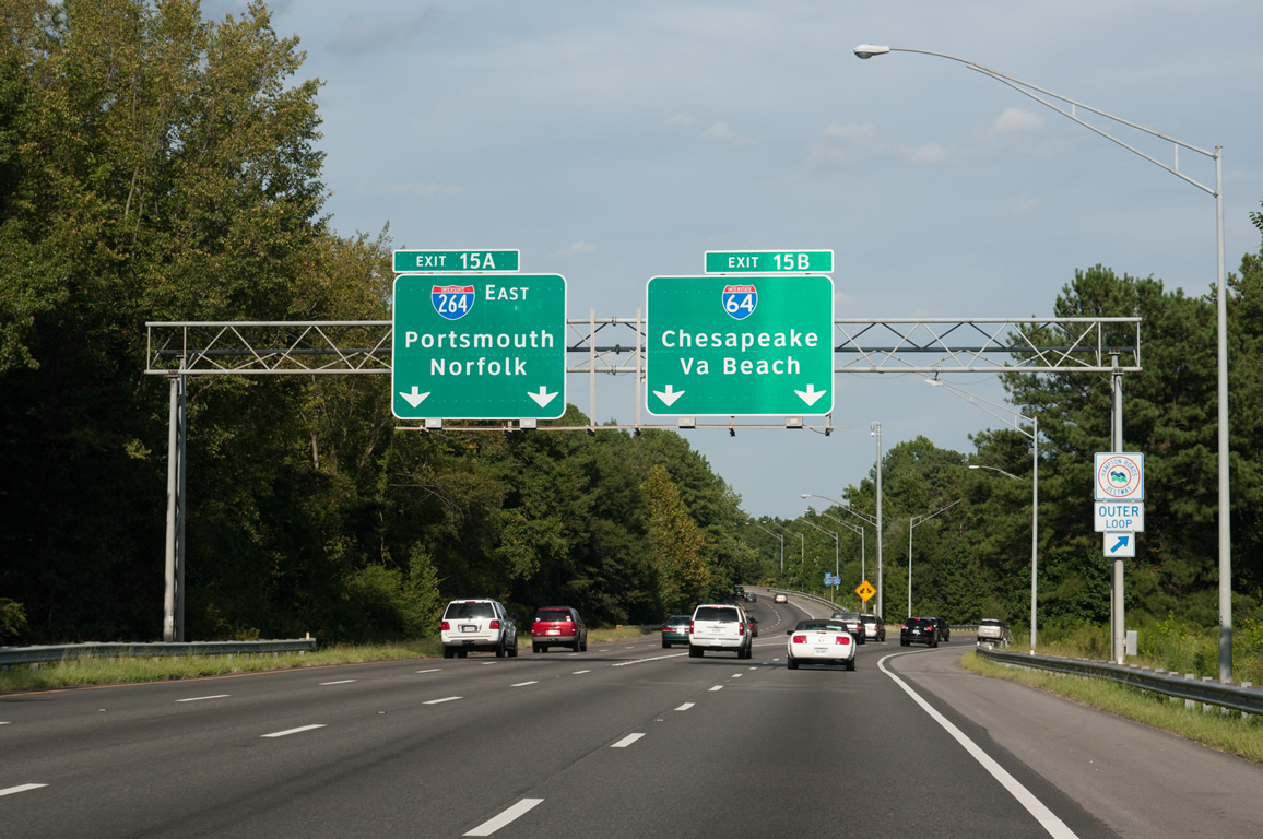
Interstate 264 runs northeasterly from I-664 to Portsmouth and the tolled Downtown Tunnel into Norfolk. I-64 extends the Hampton Roads Beltway southeast to Yadkin and Chesapeake, where it meets I-464 north and SR 168 south. Photo by Will Weaver (09/05/10).

An end shield appears for I-664 south on the connection to I-264 east. Interstate 264 enters the city of Portsmouth prior to Exit 2 and the city of Norfolk by Exit 8. 07/28/13

The ramp connecting I-664 south with Interstate 64 leading east toward Virginia Beach also includes an end shield. 12/14/17
![]() at
at ![]()
![]()

Interstate 64 / Hampton Roads Beltway inner loop curves northward into the exchange with I-264 east to Norfolk and 664 north to Hampton. 12/14/17

The Hampton Roads Beltway mainline turns west onto Interstate 664 north as Exit 299B, while Exit 299A joins I-264 east leading through the city of Portsmouth. 12/14/17
South End Throwback
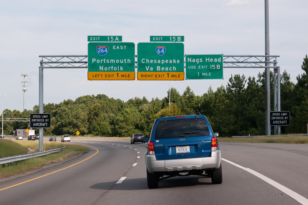
These overheads for the south end of I-664 were replaced in kind by 2016, with the exception that Nags Head was changed to Outer Banks. Photo by Will Weaver (09/05/10).

This set of signs posted along I-664 south at the exit for U.S. 13 north / U.S. 460 east was replaced by 2011. U.S. 13/460 follow Military Highway east 6.8 miles to Interstate 464. Photo by Jonathan Lebowitz (08/02).

Former overheads posted at the separation into ramps for I-264 east (Exit 15A) and I-64 outer (Exit 15B). The West cardinal direction was greened out for Interstate 64. Photo by Jonathan Lebowitz (08/02).
Sources:
- “Dredging Will Begin For I-664 Project.” Richmond Times-Dispatch (VA), February 13, 1986.
- “State to Get $149.7 Million to Complete I-664 Tunnel.” Richmond Times-Dispatch (VA), May 7, 1986.
- “I-664 Tunnel Contract is Most Expensive Ever.” Richmond Times-Dispatch (VA), August 22, 1986.
- “Newport News Link Opened.” Richmond Times-Dispatch (VA), September 17, 1987.
- “Firs Tunnel Segment Place in I-664 Project.” Richmond Times-Dispatch (VA), March 31, 1988.
- “Tunnel’s Last Tube in Place.” Richmond Times-Dispatch (VA), June 28, 1989.
- “Tunnel Project Almost Complete.” Richmond Times-Dispatch (VA), August 6, 1990.
- “I-664 Scheduled to Open in April.” Richmond Times-Dispatch (VA), June 5, 1991.
- “I-64 to be Widening West of Gaskins – Bridge is Named.” Richmond Times-Dispatch (VA), September 20, 1991.
- “7-Mile Stretch of Interstate 664 Opens in Suffolk.” Richmond Times-Dispatch (VA), January 18, 1992.
- “$400 Million Bridge-Tunnel is Agency’s Pride and Joy.” Richmond Times-Dispatch (VA), April 25, 1992.
- “$I-664 Bridge-Tunnel Opened to Traffic – Span Finishes Highway Link.” Richmond Times-Dispatch (VA), April 30, 1992.
- “On Your Mark, Get Set, Cross!” Richmond Times-Dispatch (VA), April 30, 1992.
- “I-664 Section is Set to Open Next Month.” Richmond Times-Dispatch (VA), August 22, 1987.
- Interstate 664 History, Roads to the Future web site (Scott Kozel).
Page updated July 14, 2021.