|
| Leading away from Interstate 41, U.S. 45 advances a half mile to CTH-T. County T connects the freeway with parallel County S as it follows the old alignment of Wis 110. 03/02/16 |
|
| The first U.S. 45 reassurance shield beyond I-41 precedes bridges across a tributary of Lake Butte Des Morts. Assemblies for U.S. 45 reference U.S. 10 until the interchange with the east-west freeway. Stearns Drive along the east side here is the old alignment of Wis 110. 03/02/16 |
|
| Entering the diamond interchange with Winnebago County T on U.S. 45 north. County T travels north to the unincorporated community of Larson. 03/02/16 |
|
| Confirming marker for U.S. 45 posted as the freeway advances beyond CTH-T. CTH-S runs just to the west along old Wis 110 to Butte des Morts. 03/02/16 |
|
| U.S. 45 winds northwest 3.8 miles to next meet Wis 116 west and County GG east at a diamond interchange. Wis 116 serves the village of Winneconne. It is also the only Wolf River crossing between I-41 and U.S. 10. 03/02/16 |
|
| County GG leads back east to County A at Lake Winnebago, serving local traffic. Wis 116 totals just 14.2 miles west and south from U.S. 45 to Wis 91 at Waukau. 03/02/16 |
|
| U.S. 45 turns more northerly from Wis 116 by Lake Breeze Golf Club to directly overlay old Wis 110. 03/02/16 |
|
| New London, 19 miles to the north, is where U.S. 45 meets back with its original alignment. 03/02/16 |
|
| Rock cut just south of the Breeze Wood Lane overpass east of Lake Winneconne. 03/02/16 |
|
| Upcoming County II is old Wis 150 and Wis 110. Wis 150 was downgraded to a county road when the U.S. 10 freeway opened, along with Wis 110 west of U.S. 45. It serves the unincorporated communities of Winchester and Zittau. 03/02/16 |
|
| U.S. 45 crosses underneath County II ahead of the freeway along U.S. 10 between Fremont and Appleton. 03/02/16 |
|
| A semi directional T interchange splits traffic between U.S. 10 east and west. The majority of traffic follows the two left lanes for U.S. 10/45 north toward Stevens Point and New London. 03/02/16 |
|
| Passing over the eastbound lanes of U.S. 10, U.S. 45 north combines with U.S. 10 west as the freeway traverses wetland areas associated with the Rat River. 03/02/16 |
|
| Resuming a northward heading, U.S. 45 transitions initially into an at-grade four lane expressway with a 55 MPH speed limit. 03/02/16 |
|
| Just north of the Winnebago County line, U.S. 45 intersects County W west. County W was cut short when the U.S. 10 / 45 freeway displaced it from Winchester northwestward. The trunk highway angles northwest to Readfield otherwise. 03/02/16 |
|
| U.S. 45 straddles the Waupaca and Outagamie County line on the nine mile drive north to New London. This stretch was County D until 2003 when U.S. 45 was rerouted onto the shorter alignment between New London and Oshkosh. 03/02/16 |
|
| U.S. 45 downgrades into a rural two lane road beyond CTH-W. 03/02/16 |
|
| 1.4 miles further north, U.S. 45 approaches Wis 96. Wis 96 is the old alignment of U.S. 10 between Appleton and Fremont. It was extended in 2003 when the new freeway opened. 03/02/16 |
|
| Entering the signalized intersection with STH-96 on U.S. 45 north. STH-96 west extends to Readfield and STH-110 outside Fremont. The trunk highway east continues to Dale, Medina and Exit 138 of I-41. 03/02/16 |
|
| Progressing north, U.S. 45 reaches New London in seven miles and Clintonville in 24 miles. The Langlade County seat of Antigo is 77 miles away. 05/20/16 |
|
| Reducing back to two lanes U.S. 45 plies across agricultural areas for next two miles. 05/20/16 |
|
| Crossing over the CN Neenah Subdivision Rail line along U.S. 45 north, east of North Readfield. 05/20/16 |
|
| U.S. 45 lowers in elevation through a forested area west of Shady Lake. 05/20/16 |
|
| Forthcoming County TT travels east to County M (Nash Street) within the village of Hortonville. 05/20/16 |
|
| Passing through a rock cut, U.S. 45 undulates again as it crosses Potters Creek. 05/20/16 |
|
| U.S. 45 meets County D beyond an overpass carrying Manske Road west / Givens Road east. U.S. 45 replaced the county trunk highway south of New London when it was realigned west from Greenville. 05/20/16 |
|
| County D travels into New London via Division Street as U.S. 45 splits from its original alignment onto a 2003-built roadway towards the New London Bypass. 05/20/16 |
|
| Another rock cut takes U.S. 45 north from County D just west of a large quarry. 05/20/16 |
|
| An underpass takes Cross Road east from adjacent CTH-D to Wis 15 below the U.S. 45 expressway. 05/20/16 |
|
| The U.S. 45 expressway divides into four lanes as it approaches Wis 15. 05/20/16 |
|
| Wis 15 was U.S. 45 until 2003, when U.S. 45 was relocated between New London and Oshkosh. Business U.S. 45 was designated after the New London Bypass was built in 1994. 05/20/16 |
|
| County T was extended into New London to designate the Outagamie County maintained roadway along old U.S. 45. Like nearly all business routes in Wisconsin, Business U.S. 45 is a local designation. 05/20/16 |
|
| Traffic headed to New London turns left onto Business 45/County T ahead while Wis 15 heads towards Hortonville and Greenville. Wis 15 will be reconstructed as a four lane highway from this intersection east to the existing four lane stretch in Greenville starting in 2018. 05/20/16 |
|
| A mini trombone assembly to the left was chosen for a second signal instead of replacing the entire array with a monotube signal assembly. Wisconsin used one horizontal overhead signal until 2009, when it started using vertical signals above each lane for overhead assemblies. 05/20/16 |
|
| The first U.S. 45 reassurance sign on the New London Bypass. 05/20/16 |
|
| The New London Bypass was constructed as a Super Two expressway. An at-grade turn off lies ahead for the Wolf River Shoreline Fishing Area. 05/20/16 |
|
| The lone exit along the bypass joins U.S. 45 with Wis 54 (Fairview Drive) in one mile. 05/20/16 |
|
| U.S. 45 curves north from a horseshoe lake off the Wolf River to span the waterway east of Memorial Park in New London. 05/20/16 |
|
| Water Street, the former alignment of County S between U.S. 45 Business (Shawano Street) and current County S just to the east, passes under the New London Bypass without direct access. 05/20/16 |
|
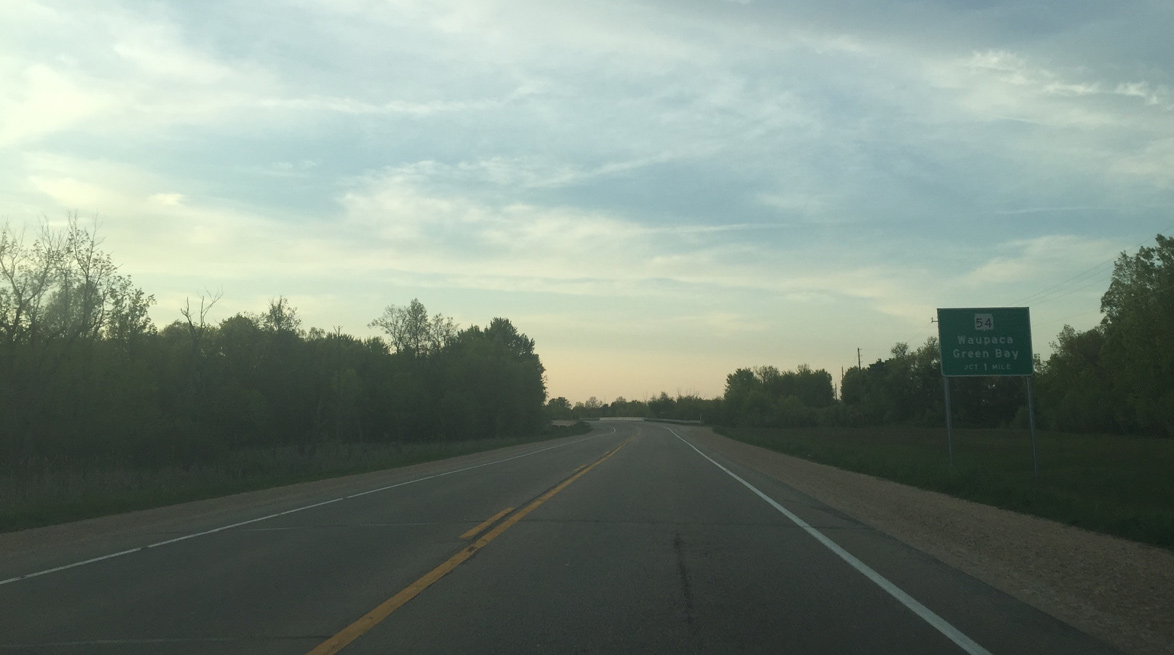
| A parclo interchange was constructed with Wis 54. Wis 54 traverses the entire state of Wisconsin. Green Bay is 35 miles to the northeast while Waupaca is 20 miles to the southwest. 05/20/16 |
|
| U.S. 45 crosses both Wis 54 and the Embarrass River on the same span. 05/20/16 |
|
| Clintonville, 15 miles to the north, is the next community that U.S. 45 passes through. 05/20/16 |
|
| South of New London, U.S. 45 traveled directly on the Outagamie/Waupaca County line. The bypass shifted the route east into Outagamie County to Wis 54, where U.S. 45 again runs along the Waupaca County line to Spurr Road. North of Spurr Road, U.S. 45 kinks west to fully enter Waupaca County, which it stays through until it enters Shawano County northwest of Clintonville. 05/20/16 |
|
| County D veers east from Old Highway 45 and intersects U.S. 45 again. The US route and Old Highway 45 come together in another 1.3 miles at Church Road. 05/20/16 |
|
| Passing lane for northbound traffic on U.S. 45 north ahead of Crain Road in the town of Lebanon. New construction projects throughout Wisconsin are adding more passing lanes to ease traffic on two lane connector roadways such as U.S. 45. 05/20/16 |
|
| The southbound lanes have a passing lane north of Elm Tree Road. This sign warns northbound motorists to pass only when no traffic is present in either of the two southbound lanes. 05/20/16 |
Page Updated 06-10-2016.


 North
North