U.S. 40 (Pulaski Highway) travels through the Cecil County seat of Elkton, comprising the main commercial arterial route across town.
|
| Beginning at State Road, Delaware, Pulaski Highway follows U.S. 40 west into Cecil County by car dealerships and several subdivisions. Formerly corn fields, adjacent development was the site of a plane crash on December 8, 1963 that resulted in the death of 81 aboard a Pan American Boeing 707. Lightning from a thunderstorm ignited fuel vapor causing an explosion that sent Flight 121 down. 08/27/21 |
|
| U.S. 40 (Pulaski Highway) intersects the south end of MD 781 (Delancy Road) just beyond the signal with Chesapeake Boulevard. 08/27/21 |
|
| A traffic signal was installed along U.S. 40 at MD 781 (Delancy Road) north by 2001. MD 781 runs 1.01 miles north to MD 281 (Red Hill Road). The popular shortcut succumbed to suburban development in the 1990s. 08/27/21 |
|
| Confirming marker posted west of MD 781 (Delancy Road). Downtown Elkton lies 2.7 miles ahead. 08/27/21 |
|
| U.S. 40 (Pulaski Highway) west at Melbourne Boulevard north by the Village oF Elkton shopping center. 08/27/21 |
|
| MD 7 Segment D branches northwest from U.S. 40 along Delaware Avenue toward Downtown Elkton. 08/27/21 |
|
| MD 7 (Delaware Avenue) angles 1.25 miles northwest from U.S. 40 to MD 281 (Red Hill Road) and the one way couplet of Howard Street east and Main Street west to Downtown Elkton. 08/27/21 |
|
| U.S. 40 (Pulaski Highway) passes well south of the Elkton town center along a commercial arterial. 08/27/21 |
|
| White Hall Road angles 0.48 miles southwest from MD 7 (Delaware Avenue) to U.S. 40. White Hall Road continues 0.59 miles south as a cut off to MD 213 (Augustine Herman Highway). 08/27/21 |
|
| Reassurance marker posted west of White Hall Road in Elkton. 08/27/21 |
|
| U.S. 40 (Pulaski Highway) west next intersects the signalized entrance to Big Elk Shopping Centre. 08/27/21 |
|
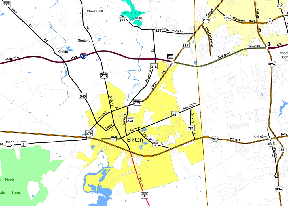
| U.S. 40 (Pulaski Highway) converges with MD 213 (Bridge Street / Augustine Herman Highway) at a busy intersection south of Downtown Elkton. MD 213 was formerly U.S. 213 south from U.S. 40 until 1971. 08/27/21 |
|
| MD 213 links the Cecil County seat with the Eastern Shore of Maryland by way of Chesapeake City, Cecil, Galena and U.S. 301. Northward MD 213 extends to Fair Hill and PA 841 at Lewisville and the Pennsylvania state line. 08/27/21 |
|
| MD 213 south concludes at Wye Mills. U.S. 213 was formerly an intrastate route, originally running south to Ocean City along the Atlantic Coast. U.S. 213 was eventually truncated by the extension of U.S. 50 and eliminated with the relocation of U.S. 301. 08/27/21 |
|
| West of MD 213 (Bridge Street / Augustine Herman Highway), U.S. 40 lowers to cross Big Elk Creek by Marina Park. 08/27/21 |
|
| A distance sign for North East appears along U.S. 40 westbound by Big Elk Creek. 08/27/21 |
|
| Formerly part of MD 7, Landing Lane links U.S. 40 with Main Street 0.17 miles to the north. Landing Lane continues 0.44 miles south of Pulaski Highway to Old Field Point Road and Hollinsworth Park. 08/27/21 |
|
| West of Jeffers Street, U.S. 40 (Pulaski Highway) spans the AMTRAK Northeast Corridor and Little Elk Creek on succeeding bridges. 08/27/21 |
|
| Continuing west from Little Elk Creek, U.S. 40 (Pulaski Highway) meets MD 279 (Elkton Road) north and MD 7 Segment C (Old Philadelphia Road) west. 08/27/21 |
|
| Forming a multi state route with SR 279 into Newark, Delaware, MD 279 (Elkton Road) travels 4.95 miles northeast from Elkton to the First State. MD 7 parallels U.S. 40 along Old Philadelphia Road west to the town of North East. 08/27/21 |
|
| MD 279 comprises a four lane highway east from MD 268 (North Street) to Interstate 95 at Exit 109. 08/27/21 |
|
| U.S. 40 proceeds west 4.11 miles from MD 7/279 (Elkton Road) to the next traffic light at Mechanics Valley Road. 08/11/05 |
|
| MD 272 (North East Road) converges with U.S. 40 (Pulaski Highway) by the town of North East. MD 272 travels 1.5 miles north from Pulaski Highway to Interstate 95 at Exit 100. 07/31/04 |
|
| MD 272 runs northward from the north end of Chesapeake Bay at Elk Neck and Turkey Point through North East to U.S. 40. Part of a multi state route, MD 272 continues into the Keystone State as PA 272 en route to Nottingham and Lancaster. 10/13/04 |
|
| U.S. 40 transitions into a rural highway west from MD 272 (Mauldin Avenue) and North East. 05/01/04 |
|
| MD 7 Segment C (Old Philadelphia Road) loops south from U.S. 40 (Pulaski Highway) into the town of Charlestown. 05/01/04 |
|
| MD 7 Segment C (Old Philadelphia Road) concludes at U.S. 40 a half mile ahead of MD 7 Segment B (Principio Furnace Road) at Belvidere Road. 05/01/04 |
|
| MD 7 Segment B spurs 3.56 miles southwest from U.S. 40 (Pulaski Highway) to Broad Street at the AMTRAK overpass beyond Downtown Perryville. Belvidere Road heads 4.52 miles north through a large industrial park to a planned interchange with I-95. 05/01/04 |
|
| U.S. 40 (Pulaski Highway) undulates west over a series of hills between MD 7 (Principio Furnace Road) and the town of Perryville. 05/01/04 |
|
| MD 222 (Aiken Avenue) stems 0.67 miles north from MD 7 (Broad Street) and the Perryville town center to U.S. 40 (Pulaski Highway) east of the Hatem Bridge. 05/01/04 |
|
| Continuing north from U.S. 40 and Perryville, MD 222 (Perryville Road) connects with Interstate 95 in 1.35 miles at Blythedale. MD 222 was formerly U.S. 222 north to Port Deposit along the Susquehanna River and U.S. 1 at Conowingo. 05/01/04 |
|
| Weigh stations operate along both directions of U.S. 40 between MD 222 and the Hatem Bridge. 05/01/04 |
|
| The Thomas J. Hatem Memorial Bridge is a through arch bridge connecting Perryville with Havre de Grace across the Susquehanna River. 06/01/04 |
|
| Opened to traffic in August 1940, the Thomas J. Hatem Memorial Bridge is the last vehicular bridge that crosses the Susquehanna River before it empties into Chesapeake Bay. 05/01/04 |
|
| All electronic tolls are implemented for the 1.5 mile long span in the eastbound direction. 05/01/04 |
|
| U.S. 40 enters Harford County midway across the Thomas J. Hatem Memorial Bridge above Garrett Island. 05/01/04 |
|
| U.S. 40 (Pulaski Highway) lowers from the Hatem Bridge into the city of Havre De Grace. 05/01/04 |
|
| Curving southwest from the Hatem Bridge, U.S. 40 enters the Havre De Grace street grid at Erie Street. 06/01/04 |
|
| MD 155 (Ohio Street) south ties into U.S. 40 at the signalized intersection with Otsego Street (MD 7 Segment A) west of Downtown Havre De Grace. MD 155 loops 9.06 miles west from U.S. 40 to I-95 at Exit 89 and MD 22 at Churchville. 06/01/04 |
|
| Entering the city of Aberdeen, U.S. 40 meets MD 22 (Aberdeen Throughway) at a parclo interchange. 06/30/10 |
|
| MD 22 leads 3.10 miles northward from the Aberdeen Proving Ground along Aberdeen Thruway to U.S. 40 (Philadelphia Boulevard) and Interstate 95. The state route travels 12.91 miles overall between the Army base and MD 924 in Bel Air. 06/30/10 |
|
| U.S. 40 westbound crosses northern reaches of Otter Point Creek as a connector (MD 24 segment D) joins Pulaski Highway with MD 24 (Emmorton Road) prior to this shield assembly. 06/30/10 |
|
| A handful of fast food restaurants and other services line U.S. 40 (Pulaski Highway) west to Joppatown. MD 755 (Edgewood Road) spurs 1.79 miles south through the unincorporated community of Edgewood to the Wise Road Gate into Aberdeen Proving Ground. 06/30/10 |
|
| MD 755 (Edgewood Road) is one of three state routes to provide access to Aberdeen Proving Ground west of Otter Point Creek. The other two are MD 24 (Emmorton Road) and MD 152 (Magnolia Road). 06/30/10 |
|
| Campbell Boulevard, a 2.22 mile long arterial loop east to MD 43, replaced Mohrs Lane at U.S. 40 (Pulaski Highway). 08/27/05 |
|
| West from Middle River Road, U.S. 40 (Pulaski Highway) advances to a grade separated intersection with MD 700 (Martin Boulevard). 08/27/05 |
|
| MD 700 (Martin Boulevard) is a controlled access arterial connecting U.S. 40 with MD 150 (Eastern Boulevard) at Middle River and Chesapeake Industrial Park, 1.97 miles to the east. 08/27/05 |
|
| Martin Boulevard crosses Victory Villa, Aero Acres and other neighborhoods east to big box retail at Middle River Road and a parclo interchange with MD 150. U.S. 40 continues 1.25 miles west to meet the Baltimore Beltway at Rossville. 08/27/05 |
|
| Shifting north across the CSX Railroad, U.S. 40 westbound next intersects Rossville Boulevard. 12/28/07 |
|
| A mixture of commercial and industrial businesses line U.S. 40 at Rossville. Rossville Boulevard angles southeast through Pulaski Industrial Park to Mace Avenue at Stemmers Run. Northward, the arterial parallels I-695 toward Fullerton. 12/28/07 |
|
| A cloverleaf interchange joins U.S. 40 (Pulaski Highway) with Interstate 695. The outer loop of I-695 heads north to Overlea, Carney and Towson. 12/28/07 |
|
| The loop ramp for I-695 south (inner loop) to Essex, Dundalk, and the Francis Scott Key Bridge separates from Golden Ring Road just off U.S. 40 westbound. Golden Ring Road becomes part of MD 588 north of MD 7 (Philadelphia road) in 0.38 miles. 12/28/07 |
|
| Industrial frontage continues west along U.S. 40 (Pulaski Highway) from the Baltimore Beltway to Rosedale. 12/28/07 |
|
| Chesaco Avenue arcs southeast from U.S. 40 to Batavia Park and the Chesaco Park community on the Back River. 12/28/07 |
|
| Chesaco Avenue north ties into parallel MD 7 (Philadelphia Road) nearby. 12/28/07 |
|
| U.S. 40 proceeds west from Chesaco Avenue across Redhouse Creek in Rosedale. 12/28/07 |
|
| U.S. 40 undulates west by Rosedale Industrial Park to meet Interstate 95 southbound in one mile. This sign for I-95 preceding Rosedale Avenue was removed by 2012. 12/28/07 |
|
| Unmarked from U.S. 40 westbound, 66th Street represents the eastbound beginning of MD 7 to Philadelphia Road. 66th Street ties into Pulaski Highway across from an industrial park while the westernmost segment of MD 7 stretches 22.82 miles east to U.S. 40/MD 159 at Aberdeen. 12/28/07 |
|
| Old Philadelphia Road (MD 7BA) extends 0.18 miles west to merge directly onto U.S. 40 (Pulaski Highway) ahead of the Baltimore city line. MD 7 follows the original route of U.S. 40 prior to the completion of the Pulaski Highway in 1935.1 12/28/07 |
|
| The southbound entrance ramp to I-95 from U.S. 40 west departs beyond the intersection with 62nd Street at Hollander Business Park. A northbound exit ramp connects with U.S. 40 east as the only other movement between the two routes. 12/28/07 |
|
| Interstate 95 travels south toward Downtown Baltimore and Washington from the city line. Parallel Interstate 895 bypasses the Inner Harbor area, rejoining I-95 in Howard County. 12/28/07 |
|
| I-95 crosses the Patapsco River through the tolled Fort McHenry Tunnel. All vehicles carrying hazardous materials are prohibited from using the tunnel. Moravia Park Drive Avenue loops from U.S. 40 at the ensuing signal 0.87 miles to Moravia Road north to Frankford in east Baltimore. 12/28/07 |
|
| Moravia Road branches 1.09 miles northwest from I-95 to Interstate 895 ahead of Herring Park. The controlled access arterial represents the connection from westbound U.S. 40 for I-95 north and I-895 south. 12/28/07 |
|
| The Baltimore City Fire Department (BCFD) Academy occupies the wedge of land between U.S. 40, Moravia Road, and the westbound ramp linking Moravia Road with Pulaski Highway. A pair of signalized intersections follow the Moravia Road overpass on U.S. 40 west. 12/28/07 |
|
| Traffic lights operate along U.S. 40 west beyond North Point Road at Baltimore City Department of Transportation facility. 12/28/07 |
|
| Passing over I-895 (Harbor Tunnel Thruway), U.S. 40 enters a three quarter cloverleaf interchange with U.S. 40 Truck/MD 151 (Erdman Avenue). 12/28/07 |
|
| Mapleton Avenue links U.S. 40 (Pulaski Highway) east with MD 151 (Erdman Avenue) west and MD 151 west with U.S. 40 east, 0.11 miles to the south. 12/28/07 |
|
| U.S. 40 Truck represents a sparsely signed bypass for U.S. 40 through Downtown Baltimore to the north. The truck route follows MD 151 along Erdman Avenue west to U.S. 1 (Belair Road). MD 151 overall is a 10.71 mile long route between Belair Road and Sparrows Point. 12/28/07 |
|
| MD 151 (Erdman Avenue) crosses Interstate 895 en route to North Point Boulevard and Edgemere east of the city. U.S. 40 (Pulaski Highway) continues west into the Orangeville neighborhood of east Baltimore. 12/28/07 |
05/01/04, 06/01/04, 07/31/04, 10/13/04, 08/11/05, 08/27/05, 12/28/07, 06/30/10, 08/27/21 by AARoads
Page Updated 11-04-2022.

 West
West


