
 East
East
03/30/16

The U.S. 34 Missouri River Bridge was dedicated on October 22, 2014.
03/30/16

03/30/16

03/30/16

03/30/16

03/30/16

03/30/16

03/30/16

03/30/16

03/30/16

03/30/16
East  South
South
U.S. 275 combines with U.S. 34 east from I-29 south via a loop ramp. U.S. 275 overlaps with I-29 north 12 miles to Council Bluffs.
03/30/16

U.S. 34 east and U.S. 275 run concurrent for 8.1 miles.
03/30/16

U.S. 34/275 intersect County Road L31 (195th Street) just beyond I-29 and the BNSF Railroad underpass at Pacific City.
03/30/16

03/30/16

U.S. 34/275 curve southward around Mile Hill Lake.
03/30/16

Shifting south onto an expressway bypass of Glenwood, U.S. 34/275 converge with CR L35 (221st Street) at a folded diamond interchange (Exit 8).
03/30/16

CR L35 is part of the Loess Hills National Scenic Byway.
03/30/16

CR L35 arcs southwest around the city of Pacific Junction to I-29 and northeast into Downtown Glenwood. The route represents the historic alignment of U.S. 34 west to the Plattsmouth Bridge.
03/30/16

Prior to the realignment of U.S. 34 northward onto the new Missouri River Bridge, the U.S. 275 exchange with 221st Street was unnumbered.
03/30/16

03/30/16

Part of the Waubonsie Loop Iowa Byway, CR L45 (Levi Road) stems south from U.S. 34/275 beyond a BNSF Railroad overpass.
03/30/16

Continuing beyond Glenwood Archaeological State Preserve, U.S. 34/275 meet the east end of CR H30 (Ingrum Avenue). CR H30 is old U.S. 34 leading back into Glenwood.
03/30/16

03/30/16

The four lane section of U.S. 34/275 concludes just east of CR H30 (Ingrum Avenue).
03/30/16

U.S. 34 and 275 split at 270th Street in Center township.
03/30/16

U.S. 275 runs nine mile south to Tabor along the Fremont County line. The county seat of Sidney follows in 12 miles at Iowa 2.
03/30/16

U.S. 34 proceeds 24 miles east from U.S. 275 to the Montgomery County seat of Red Oak.
03/30/16
East
03/30/16

03/30/16

Confirming marker posted eastbound at 280th Street south.
03/30/16

03/30/16

CR L55 (287th Street) leads six miles north from U.S. 34 to Silver City.
03/30/16

03/30/16

03/30/16

U.S. 34 spans the BNSF Railroad ahead of 295th Street. Parallel Jurd Avenue is the old alignment.
03/30/16

A truck climbing lane opens eastbound on the approach to County Road L63 (315th Street).
03/30/16

CR L63 heads one mile south to become Main Street at the Malvern city limits.
03/30/16

CR L63 extends north to Iowa 92 near Treynor in Pottawattamie County. CR L63 south to Malvern was designated as Iowa 41 prior to 2003.
03/30/16

03/30/16

U.S. 34 crosses Little Creek and intersects 330th Street north ahead of this shield assembly.
03/30/16

County Road L66 (350th Street) runs 31.3 miles north to Main Street in the city of Minden.
03/30/16

03/30/16

U.S. 34 runs along the north side of the Hastings city limits from CR M16 (360th Street) to 365th Street.
03/30/16

03/30/16

County Road H34 forms a loop south from U.S. 34 along Jamison Road into Emerson.
03/30/16

CR M21 (390th Street) crosses U.S. 34 north to Henderson and south to Imogene.
03/30/16

03/30/16

U.S. 34 meets U.S. 59 at a grade separated intersection north of Emerson.
03/30/16

U.S. 59 bypasses Emerson to the east southward en route to Shenandoah and Fairfax, Missouri.
03/30/16

The overpass carrying U.S. 59 across U.S. 34 dates to 1964.
03/30/16

U.S. 59 travels 20 miles north to Oakland in Pottawattamie County and 45 miles to Harlan.
03/30/16

U.S. 34 east at the access road connecting with U.S. 59.
03/30/16

03/30/16

U.S. 34 enters Montgomery County just ahead of Indian Creek and 27.3 miles from the Nebraska state line.
03/30/16
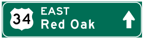

Photo Credits:
03/30/16 by AARoads
Connect with:
Interstate 29
U.S. 275
Page Updated 12-17-2019.