
U.S. 6 crosses Utah from the Snake Valley in Nevada 373.96 miles to the Grand Valley leading into Colorado. Running concurrently with U.S. 50, U.S. 6 traverses remote areas of Millard County across the Ferguson Desert, Confusion Range and Tule Valley. Curving northward around the House Range, U.S. 6/50 continue north of the dry bed of Sevier Lake through the Sevier Desert to Hinckley and Delta. The two highways part ways in Delta, concluding an 89.40 mile overlap east from the state line.
U.S. 50 turns southward through the Pahvant Valley, connecting with I-15 at Holden. U.S. 6 remains northeasterly to Lynndyl and Little Sahara National Recreation Area. Turning more north through Tintic Valley, U.S. 6 meets SR 36 north to Tooele.
Ascending to over 6,000 feet in elevation, U.S. 6 passes over the East Tintic Mountains through Homansville Canyon and Big Canyon. The route then flattens out across the Goshen Valley to Elberta and Goshen. U.S. 6 circumvents Warm Springs Mountain to the city of Santaquin, where it combines with Interstate 15 north.
The 12.86 mile concurrency with I-15 bypasses the former alignment (SR 198) through Spring Lake, Payson, Salem and Spanish Fork. Separating with the freeway at Exit 257, U.S. 6 angles southeast along a controlled access arterial through suburban areas of Spanish Fork. The four lane highway winds through Spanish Fork Canyon as it accompanies a portion of U.S. 89 and ascends over the Wasatch Range to Soldier Summit in Wasatch County.
Trending southward, U.S. 6 reenters Utah County to Colton and climbs again through Price Canyon in Carbon County. U.S. 191 combines with U.S. 6 south at milepost 229.95, and the two advance southeast to Helper and a freeway bypass around Price. Beyond Wellington, U.S 6/191 travel through sparsely populated areas southward by the Book Cliffs to Gunnison Valley and Interstate 70.
U.S. 6/191 accompany Interstate 70 and U.S. 50 through Green River. U.S. 6 overlays the freeway for 70.60 miles to the Colorado State line and overall to Grand Junction.
 East East |
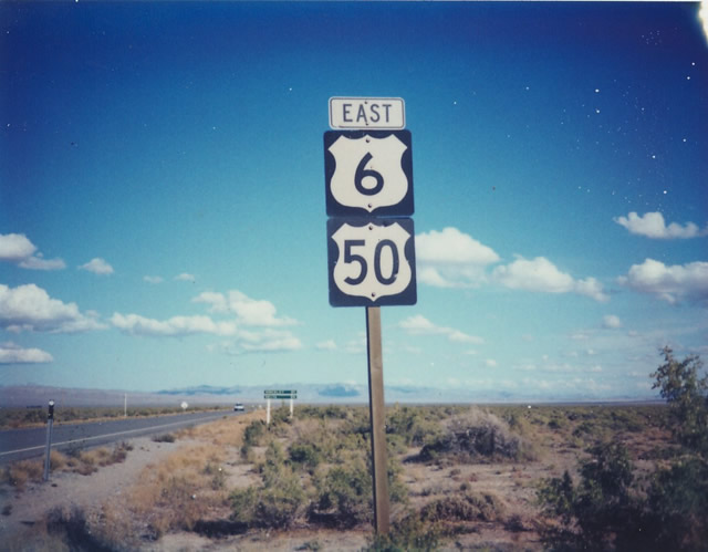
 | Eastbound U.S. 6 combines with Interstate 15 north between Santaquin and Spanish Fork. This shield assembly is posted at the diamond interchange joining the two routes at the east end of Main Street in Santaquin. 06/07/10 |
Photo Credits:
06/07/10 by Landry Heaton
Connect with:
Interstate 15
Interstate 70
U.S. 50
U.S. 89
U.S. 191
Page Updated 07-31-2018.