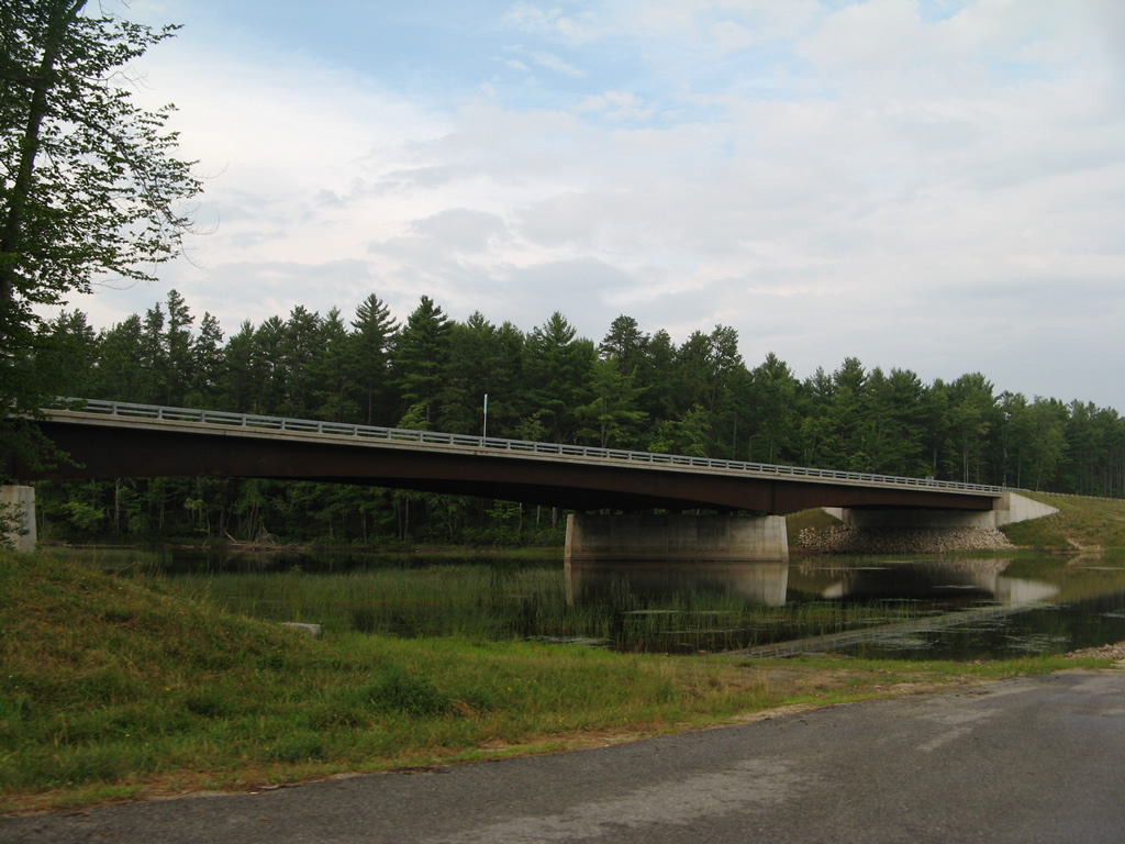
New Hampshire 25 crosses the Ossipee River on this 2004-built bridge just east of NH 153. Construction of the span included realigning the state route north of its former crossing, which was partially repurposed as a boat ramp. Photo taken July 27, 2007.
An original New England Interstate Route, New Hampshire 25 stretches across the Granite State for 96.6 miles from Piermont to Freedom. The state route winds southward from Haverhill and Warren through the Baker River Valley to combine with U.S. 3 at Plymouth for an 18.4 mile overlap south to Ashland and east to Squam Lake and Meredith.
Splitting from U.S. 3, New Hampshire 25 heads toward Center Harbor and northern reaches of Lake Winnipesaukee. The route arcs east around the Ossipee Mountains to Ossipee Lake and Center Ossipee, sharing pavement with a variety of routes including New Hampshire 16. The final stretch takes NH 25 east through Effingham and East Freedom to become Maine 25 en route to Porter and Portland.
|
| NH 25 spans the Ossipee River just beyond the split with NH 153 (Province Lake Road) south. 07/29/07 |
|
| The Ossipee River represents the Effingham and Freedom town line across NH 25. Porter Road carries the final 2.4 miles of NH 25 east. 07/29/07 |
|
| Old Portland Road winds southeast from the Freedom town center by Loon Lake to end at NH 25 (Porter Road). 07/29/07 |
|
| The final shield for NH 25 east follows Old Portland Road at the settlement of East Freedom. 07/29/07 |
|
| Huntress Bridge Road extends east from the split with NH 153 to end at NH 25 (Porter Road) at East Freedom. 07/29/07 |
|
| A steel truss bridge carries Huntress Bridge Road across the Ossipee River just south of NH 25 (Porter Road). The span was built in 1936 and reconstructed in 1994. 07/29/07 |
|
| NH 25 continues into the town of Porter as Maine 25. 07/29/07 |
|
| A Maine State Route 25 assembly appears just east of the state line. The route parallels the Ossipee River and York County line east to the Porter town center and Kezar Falls. 07/29/07 |
|
| Welcome to Maine sign posted along SR 25 (Ossipee Trail) east. 07/29/07 |
|
| SR 25 advances five miles east to Kezar Falls and nine miles across the Ossipee River to Cornish. 07/29/07 |
|
| Crossing the New Hampshire line, SR 25 becomes NH 25 through East Freedom and Carroll County. 07/29/07 |
|
| Huntress Bridge Road angles southwest from East Freedom to NH 153 south for Effingham. 07/29/07 |
|
| Huntress Bridge Road crosses the Ossipee River on this 1936-built truss bridge to end at NH 25 (Porter Road) just west of the Maine line. 07/29/07 |
|
| The first shield for NH 25 follows along Porter Road west. 07/29/07 |
|
| Old Portland Road branches northwest from NH 25 (Porter Road) west to the Freedom town center by Loon Lake. 07/29/07 |
|
| NH 25 (Porter Road) veers west to pass south of Loon Lake. 07/29/07 |
|
| A Welcome to New Hampshire sign greets westbound motorists just after East Freedom. 07/29/07 |
|
| Spanning the Ossipee River into the town of Effingham, NH 25 approaches NH 153 (Province Lake Road) south. 07/29/07 |
|
| NH 153 leads south five miles to Center Effingham and nine miles to Province Lake. The state route travels 50.7 miles overall between Conway to the north and Farmington to the south. 07/29/07 |
|
| NH 25 west & 153 north overlap west for 0.8 miles. School Street splits from the state route ahead as the former alignment of both routes to Iron Works Road at Eaton Road. 07/29/07 |
|
| School Street arcs northward to Effingham Falls as NH 25 & 153 prepare to split at Eaton Road. 07/29/07 |
|
| NH 153 journeys northward five miles to East Madison and eight miles by a series of ponds and Lyman Mountain to Eaton Center. Connections with Freedom Village Road north of Freedom Falls and the Ossipee River lead motorists to the Freedom town center. 07/29/07 |
|
| NH 25 ventures west from NH 153 (Eaton Road) six miles to Center Ossipee and 38 miles to the merge with U.S. 3 at Meredith. 07/29/07 |
|
| Green Mountain Road ties into the split of NH 25 and 153 from the south. The road encircles Green Mountain southward toward Pine River. 07/29/07 |
|
| NH 25 (Ossipee Trail) gradually curves southwest toward Ossipee Lake. 07/29/07 |
|
| The Ossipee Mountains appear to the southwest in this scene along NH 25 (Ossipee Trail) west after Marist Road. 07/29/07 |
|
| Reassurance signs for NH 25 continue to include a trailblazer for NH 16 on the southward drive to Center Ossipee. This assembly resides after the intersection with Pequawket Trail north and Ryefield Road south. 07/29/07 |
|
| Long Sands Road spurs northwest from NH 25 to the Long Sands community on Ossipee Lake. 07/29/07 |
|
| Crossing the Pine River along NH 25 west. 07/29/07 |
|
| A diamond interchange joins NH 25 (Ossipee Trail) west with the NH 16 expressway bypass of Center Ossipee. 07/29/07 |
|
| NH 16 & 25 overlap for 5.6 miles north to West Ossipee. NH 16 enters the town of Ossipee from Wakefield, Milton and Rochester to the south. 07/29/07 |
|
| Ossipee Trail extends south from the junction of NH 16 and 26 to NH 16B, which encircles Center Ossipee just to the east. 07/29/07 |
|
| NH 16 & 25 travel over upcoming NH 16B on a 1.7 mile exit less stretch to their expressway end. 07/29/07 |
|
| NH 16B concludes a 5.38 mile route through Ossipee at NH 16 & 25 (White Mountain Highway) by the Indian Mound Golf Club and a N.H. liquor store. 07/29/07 |
|
| The state route tandem reduce back to two lanes and travel at-grade northward to Ossipee Valley. 07/29/07 |
|
| Spanning the Bearcamp River, NH 16 & 25 (White Mountain Highway) veer away from the adjacent hillside of the Nickerson and Ossipee Mountains across a plain east of the river to West Ossipee. 07/29/07 |
|
| NH 25 prepares to split with NH 16 north onto Ossipee Mountain Highway west through the Bearcamp River valley. 07/29/07 |
|
| Heading north through West Ossipee, NH 16 travels to White Lake State Park, Chocorus and Albany before turning east to Conway in 15 miles. 07/29/07 |
|
| NH 25 continues 22 miles west to Meredith, with the Tamworth town center lieing five miles to the northwest via NH 113 from Whittier. 07/29/07 |
|
| Leading away from NH 16, NH 25 (Ossipee Mountain Highway) straddles northern reaches of the Ossipee Mountains and Mount Whittier (elevation 2,215 feet) through the town of Tamworth. 07/29/07 |
|
| NH 25 spans the Bearcamp River next. The 26.3 mile river flows southeast from Sandwich Notch in the Squam Mountains into Ossipee Lake. 07/29/07 |
|
| Whittier Road / Old Route 25 loops north from NH 25 to Whittier through south Tamworth. The old alignment carries NH 113, 0.4 miles southwest from Tamworth Road to a merge with NH 25 west. 07/29/07 |
|
| NH 113 arcs northeast two miles to the Tamworth town center and junction NH 113A north to Wonalancet. Overall the 40.4 mile route ends eastward at U.S. 302 in Conway. 07/29/07 |
|
| NH 25 & 113 share a 3.1 mile overlap west to South Tamworth and Bennett Corners. 07/29/07 |
|
| A flasher hangs above the intersection of NH 25 & 113 (Bearcamp Highway) with Mill Road north and Mountain Road south at South Tamworth. 07/29/07 |
|
| Union Hall Road, the old alignment of NH 25, loops northward from the state route before Mason Hill Road and this shield assembly. 07/29/07 |
|
| NH 113 parts ways with NH 25 (Bearcamp Highway) west onto Jackman Pond Road north ahead. 07/29/07 |
|
| NH 113A returns to NH 113 at North Sandwich in three miles. NH 25 meanwhile turns more southerly through East Sandwich on the six mile drive to Moultonboro. 07/29/07 |
|
| Little Pond Road stems west from NH 25 (Whittier Highway) to NH 109 at Sandwich on Wentworth Hill. NH 109 (Wentworth Hill Road) angles northwest from Sandwich to Center Sandwich. 07/29/07 |
|
| Continuing southward from Little Pond Road on the west side of the Ossipee Mountains. 07/29/07 |
|
| Drivers along NH 25 (Whittier Highway) west cross the Moultonborough town line ahead of Moultonborough Airport (5M3) and Berry Pond. 07/29/07 |
|
| NH 109, a multi-state route with Maine 109 between Wells and Center Sandwich, merges with NH 25 (Whitter Highway) west to the Moultonborough town center. 07/29/07 |
|
| Angling southeast, NH 109 (Governor John Wentworth Highway) meets the north end of NH 171 (Mountain Road) in 2.2 miles before turning southward to reach Melvin Village in eight miles within the town of Tulftonboro. 07/29/07 |
|
| NH 109 straddles eastern reaches of Lake Winnipesaukee from Moultonborough Bay south to Nineteenmile Bay at Union Wharf, Mirror Lake and Wolfeboro Bay at the Wolfeboro town center. 07/29/07 |
|
| An 0.8 mile overlap ensues along NH 25 west & 109 north on Whittier Highway. 07/29/07 |
|
| Mount Israel (elevation 2,625 feet) and Sandwich Mountain (elevation 3,986 feet) rise prominently to the north of this scene overlooking Berry Pond from NH 25 & 109 in Moultonborough. 07/29/07 |
|
| Entering the Moultonborough town center, NH 109 prepares to split with NH 25 (Whitter Highway) west for Holland Street north. 07/29/07 |
|
| NH 109 extends another 4.5 miles north to end at NH 113 in Center Sandwich. 07/29/07 |
|
| Maine 109 and NH 109 total 67.2 miles. 07/29/07 |
|
| A flasher hangs above the intersection between NH 25 (Whittier Highway) and 109 (Holland Street). 07/29/07 |
|
| Leaving the Moultonborough town center, NH 25 progresses southwest to Garland Pond and Moultonborough Falls. 07/29/07 |
|
| Blake Road leads southeast from NH 25 (Whittier Highway) to Lees Mill. 07/29/07 |
|
| Westbound shield for NH 25 posted after Blake Road. The state route passes between Garland and Lees Pond over the next half mile. 07/29/07 |
|
| West from Moultonborough, NH 25 (Whittier Highway) enters Center Harbor at the north end of Lake Winnipesaukee. NH 25B begins at the town center. 07/29/07 |
|
| Back to back intersections join NH 25 with Bean Road and NH 25B (Dane Road). Bean Road straddles the Moultonborough town line northwest toward Squam Lake and the town of Sandwich while NH 25B provides a cutoff to U.S. 3 north & NH 25 west to East Holderness. 07/29/07 |
|
| Main Street circles west to Plymouth Street as the initial stretch of NH 25B. The state route travels wholly within the town of Center Harbor, ending at U.S. 3 & NH 25 in 3.25 miles. 07/29/07 |
Page Updated 02-19-2015.