NC 68 travels 30.60 miles north from U.S. 29 at Thomasville through High Point, western reaches of Greensboro, Oak Ridge and Summerfield. The state route concludes at I-73/U.S. 220 in southern Rockingham County. The relocation of U.S. 70 approved in 2019 overlays all of NC 68 north to W Wendover Avenue (SR 1541) at Deep River.
The US 220 / NC 68 Connector extends Interstate 73 northeast from NC 68 at Pleasant Ridge Road (SR 2133) on a new alignment to U.S. 220 at the Haw River. Construction on the roadway through Summerfield to U.S. 220 broke ground in April 2014. It was completed July 3, 2017.
|
| NC 68 leads northwest from I-40/U.S. 421 (Exit 210) along Lynwood Smith Expressway. A signalized intersection joins the state route with Triad Center Drive to an adjacent business park. 07/24/04 |
|
| A folded diamond interchange joins NC 68 with Market Street (old U.S. 421) north of Triad Center Drive. The expressway along NC 68 was built between 1980-82.1. 07/24/04 |
|
| Market Street (SR 1008) heads west to Colfax and Kernersville and east through the Piedmont Triad International Airport (PTI) industrial area to Guilford. 07/24/04 |
|
| NC 68 proceeds north to a trumpet interchange with Cornerstone Drive (SR 4464) east. Cornerstone Drive represents the western extent of what was Joseph Bryan Boulevard west from Piedmont Triad International Airport (PTI). 07/24/04 |
|
| Originally Bryan Boulevard encircled the north side of PTI Airport. The roadway was realigned from 2006 to October 2007 to accommodate the new airport runway and FedEx sorting hub. A new exchange was also built for the eventual I-73 with Ted Johnson Parkway south to the passenger terminal.2,3 07/24/04 |
|
| With Interstate 73 overtaking Joseph Bryan Boulevard west from I-840 (Greensboro Urban Loop), Bryan Boulevard southwest to NC 68 was partially abandoned. The western section linking NC 68 with Burgess Road was renamed Cornerstone Drive. 07/24/04 |
|
| A wye interchange joining NC 68 north with I-73 south to Greensboro was constructed north of Cornerstone Drive. 07/24/04 |
|
| NC 68 intersects Pleasant Ridge Road (SR 2133) just beyond the overpasses for I-73. Regional Road (old NC 68) previously tied into Pleasant Ridge Road to the east. 07/24/04 |
|
| Northward into the town of Oak Ridge, NC 68 reduces to two lanes. NC 150 (Oak Ridge Road) meets NC 68 at a commercialized intersection. 07/24/04 |
|
| NC 150 (Oak Ridge Road) travels southwest from Oak Ridge to Kernersville and northeast to U.S. 220 at Summerfield. 07/24/04 |
|
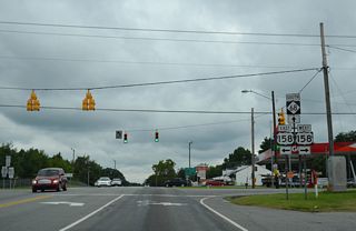
| NC 68 north meets U.S. 158 in the town of Stokesdale. U.S. 158 ventures west to Belows Lake and Walkertown and east to I-73/U.S. 220 north of Summerfield and Reidsville. 07/24/04 |
|
| NC 65 (Belows Creek Road) combines with NC 68 north for 0.72 miles through north Stokesdale. 07/24/04 |
|
| Eastbound NC 65 partitions with NC 68 ahead of the Rockingham County line for Wentworth. 07/24/04 |
|
| NC 65 and NC 68 both meet I-73/U.S. 220 two miles after their split. The 47 mile route of NC 65 from Rural Hall (U.S. 52) concludes in Reidsville. 07/24/04 |
|
| NC 68 previously concluded at a wye intersection with U.S. 220. A grade separation was constructed here with the extension of Interstate 73 north in 2017. U.S. 220 extends north along an expressway to Martinsville, Virginia. 07/24/04 |
|
| NC 68 branches southwest from U.S. 220 and I-73, 15 miles to Piedmont Triad International Airport (PTI) and 27 miles to High Point. 08/06/13 |
|
| NC 68 crosses the Guilford County and Stokesdale town line 2.56 miles south of I-73/U.S. 220. 08/06/13 |
|
| NC 68 south combines with NC 65 west 0.18 miles beyond the Rockingham County line. 08/06/13 |
|
| NC 65 leads northeast along a rural course to Bethany, Bakers Crossroads and the town of Wentworth. 08/06/13 |
|
| NC 65/68 overlap for 0.72 miles into Stokedale. 08/06/13 |
|
| Confirming markers for NC 65 west / NC 68 south posted ahead of Lester Road (SR 2048) west. 08/06/13 |
|
| NC 65 turns west onto Belews Creek Road to bypass the Stokesdale town center between NC 68 and U.S. 158. 08/06/13 |
|
| Formerly at a wye intersection, NC 65 splits with NC 68 to provide a direct route for U.S. 158 west to Walkertown and Winston-Salem. 08/06/13 |
|
| NC 65 stays west from Stokesdale to Walnut Cove and Rural Hall. 08/06/13 |
|
| Continuing south from NC 65, NC 68 lowers across Troublesome Creek. 08/06/13 |
|
| U.S. 158 runs along the main commercial strip through Stokesdale between NC 68 and NC 65. 08/06/13 |
|
| U.S. 158 leads west from NC 68 to Winston-Salem and Mocksville and east to the Rockingham County seat of Reidsville and Yanceyville. 08/06/13 |
|
| U.S. 158 stays north of the Greensboro area east to I-73/ U.S. 220 at Ogburns Crossroads and west to Belews Lake at the Forsyth County line. 08/06/13 |
|
| Although still rural, the NC 68 advances southward from Stokesdale through increasing development to the town of Oak Ridge and PTI Airport. 08/06/13 |
|
| Haw River Road (SR 2028) intersects NC 68 at Kings Crossroads. 08/06/13 |
|
| NC 68 enters the town of Oak Ridge at Harrell Road (SR 2029) west and the Haw River. 08/06/13 |
|
| NC 150 and NC 68 come together at the commercial center of Oak Ridge. NC 150 joins Oak Ridge with Kernersville to the west and Summerfield to the east. 08/06/13 |
|
| NC 150 constitutes a 183 mile route from U.S. 158 near Yanceyville southwest to the South Carolina state line, south of Boiling Springs. 08/06/13 |
|
| Continuing south from NC 150, the ensuing traffic light on NC 68 is with Alcorn Road (SR 2269). 08/06/13 |
|
| NC 68 intersects Edgefield Road (SR 2011) south of a folded diamond interchange with Interstate 73. Edgefield Road leads 1.61 miles northeast to Alcorn Road. SR 2011 west to Pleasant Ridge Road (SR 2133) was removed due to construction of I-73. 08/06/13 |
|
| NC 68 expands into an expressway ahead of Pleasant Ridge Road (SR 2113). Construction of I-73 realigned SR 2113 to the north and severed the nearby connection with Regional Road (old NC 68) south. I-73 spans both roadways in this scene now. 08/06/13 |
|
| South of Pleasant Ridge Road, NC 68 transitions to a freeway (Lynwood Smith Expressway). 08/06/13 |
|
| Heading south from I-73, NC 68 meets the former west end of Joseph M. Bryan Boulevard at a trumpet interchange. 08/06/13 |
|
| Overtaken by I-73, Bryan Boulevard previously followed the periphery of Piedmont Triad International Airport (PTI) to the Greensboro Urban Loop (I-73/840). Bryan Boulevard is a freeway east from I-73/840 to Benjamin Parkway at the Guilford Hills and Green Valley neighborhoods in Greensboro. 08/06/13 |
|
| Cornerstone Drive (SR 4464) links NC 68 with Burgess Road (SR 4156) along the former western extent of Bryan Boulevard. Bryan Boulevard was realigned between 2006 and October 2007 during expansion of PTI Airport before I-73 subsumed it. 08/06/13 |
|
| Market Street (SR 1008), the former alignment of U.S. 421 east to Highland Park in Greensboro and west to Kernersville, converges with NC 68 at a folded diamond interchange. 08/06/13 |
|
| A third lane opens southbound along NC 68 from Cornerstone Drive to Market Street (SR 1008). 08/06/13 |
|
| Market Street (old U.S. 421) head west from NC 68 to Colfax and Kernersville as Mountain Street. East from NC 68, SR 1008 continues through the airport industrial area to Guilford. 08/06/13 |
|
| A signalized intersection joins NC 68 with Triad Center Drive into an adjacent business park. 08/06/13 |
|
| NC 68 (Lynwood Smith Expressway) proceeds south into a parclo interchange with I-40/U.S. 421. 08/06/13 |
|
| Interstate 40 west / U.S. 421 north leave Greensboro on separate routes to Winston-Salem. The two overlap east to the Greensboro Urban Loop (I-73/840). 08/06/13 |
|
| The succeeding exit along I-40 west is with Sandy Ridge Road (SR 1850) for the Piedmont Triad Farmers Market. 08/06/13 |
|
| The entrance ramp for Winston-Salem, Statesville and Asheville departs NC 68 south. 08/06/13 |
|
| Albert Pick Road (SR 1681) west at Regional Road (SR 1695) near Friendship and PTI Airport. Regional Road is the former alignment of NC 68. 01/17/19 |
|
| Albert Pick Road ties into the parclo interchange joining NC 68 (Lynwood Smith Expressway) with Interstate 40 and U.S. 421. 01/17/19 |
|
| A loop ramp connects Albert Pick Road and NC 68 with I-40 east / U.S. 421 south into Greensboro. 01/17/19 |
Page Updated 07-30-2020.


