|
| I-95 overtakes Route 128 south along Yankee Division Highway at the Farm Avenue overpass in Peabody. I-95 returns west after diverging southeast from parallel U.S. 1 to cross the US route again. A directional cloverleaf interchange (Exit 44) joins I-95 with the Route 1 Connector, an access road to U.S. 1 (Newburyport Turnpike) and Route 129 (Lynnfield Street) at Salem Street. 07/28/07 |
|
| The Route 1 Connector leads north from Exit 44 to a trumpet interchange with U.S. 1 by Suntaug Lake. U.S. 1 south combines with Route 129 between South Lynnfield and North Saugus. U.S. 1 continues south from Route 129 through Saugus and Malden to the Northeast Expressway at Revere and the city of Boston. 07/28/07 |
|
| Reassurance markers for I-95/Route 128 preceding the U.S. 1 over crossing. The I-95 marker was knocked down and removed by 2012.
References to Route 128 were removed from preceding guide signs by 2011. 06/28/05 |
|
| Heading west on Yankee Division Highway, I-95 advances to a parclo interchange (Exit 43) with Walnut Street in Lynnfield. Walnut Street travels south alongside Hawkes Pond to Route 129 (Water Street) at North Saugus. 06/28/05 |
|
| Walnut Street continues north from Interstate 95 along a bluff above Reedy Meadow to Summer Street by Pillings Pond in Lynnfield. 07/28/07 |
|
| Pleasure Island Road is the short connector linking Interstate 95 and parallel Salem Street at Exit 42. Salem Street parallels Yankee Division Highway west from South Peabody to Lowell Street in north Wakefield. 06/28/05 |
|
| Traffic interests to Lynnfield and Saugus via Walnut Street depart Interstate 95 south at Exit 43. The Lynnfield town center lies west on Summer Street at Main Street via Walnut Street north. 07/28/07 |
|
| Entering the parclo interchange (Exit 42) with Pleasure Island Road along I-95 south. Pleasure Island Road leads north to Audubon Road and the Edgewater Place office park. Salem Street branches southwest from I-95 near Montrose to Lake Quannapowitt and Route 129 (Main Street) near the Wakefield town center. 07/28/07 |
|
| The folded diamond interchange at Exit 41 connects I-95 with Main Street. Main Street in Lynnfield leads southwest from the town center to become Vernon Street at the Wakefield town line. 07/28/07 |
|
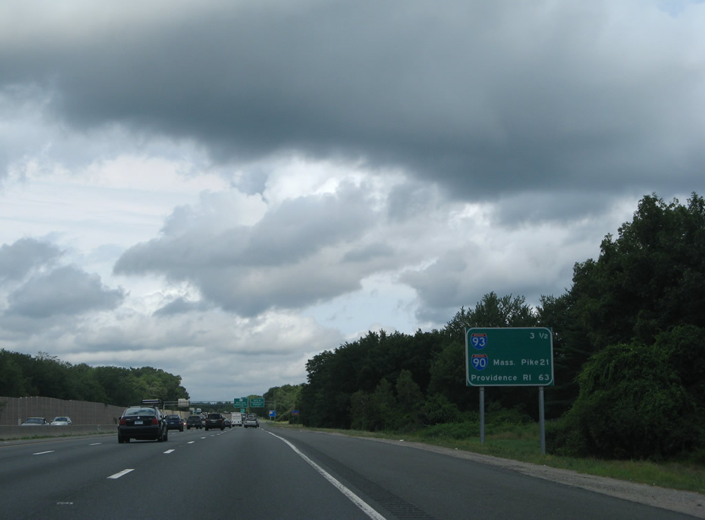
| This distance sign indicates the mileage to Interstate 93 (Exit 37), Interstate 90 (Exit 23), and the capital city of Rhode Island (63 miles). 07/28/07 |
|
| I-95 (Yankee Division Highway) meets Route 129 (Main Street) at a split diamond interchange (Exit 40) in Wakefield. Route 129 follows Water Street northwest from North Saugus to Main Street in Downtown Wakefield. The state route presses northward from there to the Reading-Wakefield Rotary with Haverhill Street, Salem Street through Reading and I-95. 07/28/07 |
|
| Exit 40 connects with Haverhill Street to the town of North Reading. Walkers Brook Drive follows at Exit 39 with North Avenue.
The freeway nips a corner of Essex County at upcoming Exit 41. 07/28/07 |
|
| Exit 41 leaves I-95 south for Main Street north to Downtown Lynnfield and Vernon Street south through east Wakefield. 07/28/07 |
|
| Exit 40 follows quickly onto the Reading-Wakefield Rotary with Route 129 (Main Street / Salem Street) and Haverhill Street. Route 129 continues west from Wakefield to both the Reading and Wilmington town centers. 07/28/07 |
|
| North Avenue meets Interstate 95 at a diamond interchange (Exit 39) alongside the Reading and Wakefield town lines. North Avenue becomes Walkers Brook Drive as it enters Reading en route to John Street and Route 129 (Salem Street). 07/28/07 |
|
| Exit 39 leaves Interstate 95 south for North Avenue south and Walkers Brook Drive north. North Avenue leads south along Lake Quannapowitt to Church Street in central Wakefield. The freeway skims southern reaches of Reading to subsequent interchanges with both Route 28 (Exit 38) and Interstate 93 (Exit 37). 07/28/07 |
|
| A cloverleaf interchange links Interstate 95 with Route 28 (Main Street) in a quarter mile. Route 28 constitutes an arterial between the Stoneham and Reading town centers. The state route travels throughout the greater Boston area. 07/28/07 |
|
| Exit 38B departs Interstate 95 south beyond the Hopkins Street over crossing. Route 28 (Main Street) travels two miles north to Route 128 in Downtown Reading and 14 miles to Lawrence. Once at the state line, Route 28 becomes NH 28 en route to Derry and Manchester. 06/28/05 |
|
| Southbound I-95 at the loop ramp (Exit 38A) onto Route 28 (Main Street) south to Stoneham and Middlesex Fells Reservation. Route 28 converges with Interstate 93 through Medford before branching eastward to Wellington. The state route continues south to Falmouth on the coast. 07/28/07 |
|
| I-93/95 meet at a cloverleaf interchange (Exits 37B/A) in south Reading. Interstate 93 is the main freeway into Downtown Boston from points northward to Manchester and Concord, New Hampshire. Locally I-93 north serves Wilmington and North Reading. 07/28/07 |
|
| Massachusetts Bay Transportation Authority facilities to the city of Boston are available via the Mishawum Transit Station of Interstate 93 north to Exit 37C. The MBTA Lowell Line travels northward along I-93 to Wilmington and Lowell. Exit 37C opened to traffic in October 2000.1 07/28/07 |
|
| Exit 37 B departs tor I-93 north to Lowell, Manchester and Concord, New Hampshire. Interstate 93 joins the Boston area with upstate Vermont via connections with I-89 at Concord and I-91 by St. Johnsbury. 07/28/07 |
|
| Interstate 93 comprises a busy route south through Stoneham and Medford, culminating where the Big Dig project was underway from the late 1990s to early 2000s. Once in Downtown Boston, I-93 crosses the Leonard P. Zakim Bunker Hill Bridge over the Charles River, before descending into the tunnel system that replaced the Fitzgerald Expressway viaducts. 07/28/07 |
Page Updated 02-12-2007.

 South
South