|
| I-74/465 overlap for 20 miles around Indianapolis. Beyond the freeway stubs at the interchanges with I-465, no construction ever took place on any part of Interstate 74 within the beltway. Most locals omit I-74 and only call the beltway Interstate 465. 12/06/12 |
|
| Two lanes join I-74/465 southbound from U.S. 136 east/Crawfordsville Road one mile ahead of Exit 14 for 10th Street and the Wayne suburban area. 06/25/22 |
|
| The Accelerate 465 project reconfigured the previous directional cloverleaf at 10th Street into a parclo interchange. 06/25/22 |
|
| 10th Street runs through the west side neighborhood of Haughville and Speedway to the east. West from Exit 14, 10th Street heads out through Chapel Hill and Westwood en route to the Hendricks County suburb of Avon. 06/25/22 |
|
| The ensuing exit from I-74/465 south is for U.S. 36 (Rockville Road) west to Avon and Danville. 06/25/22 |
|
| Originally a cloverleaf full interchange joined I-74/465 with U.S. 36 west and Rockville Road. The lone loop ramp retained joins U.S. 36 east with the beltway north. 06/25/22 |
|
| East from Exit 13, Rockville Road passes through Wayne and by Lynhurst to converge with Washington Street at Eagle Creek. There U.S. 36/40 originally combined through the west side of the city. 06/25/22 |
|
| U.S. 36 travels west from I-74/465 to Tremont. Regionally U.S. 36 leads to Decatur in central Illinois. 06/25/22 |
|
| The cloverleaf interchange with U.S. 40 (Washington Street) at Exit 12 was reconfigured during the Accelerate 465 project into a six-ramp parclo. 06/25/22 |
|
| Plainfield, a suburb in southeastern Hendricks County, is located west of Indianapolis International Airport (IND) along U.S. 40 (Main Street). 06/25/22 |
|
| U.S. 40 extends west from the Indianapolis Beltway at Exit 12 to Bridgeport and Plainfield. Washington Street east across the city is the original alignment of U.S. 40 to I-465 at Exit 46. 06/25/22 |
|
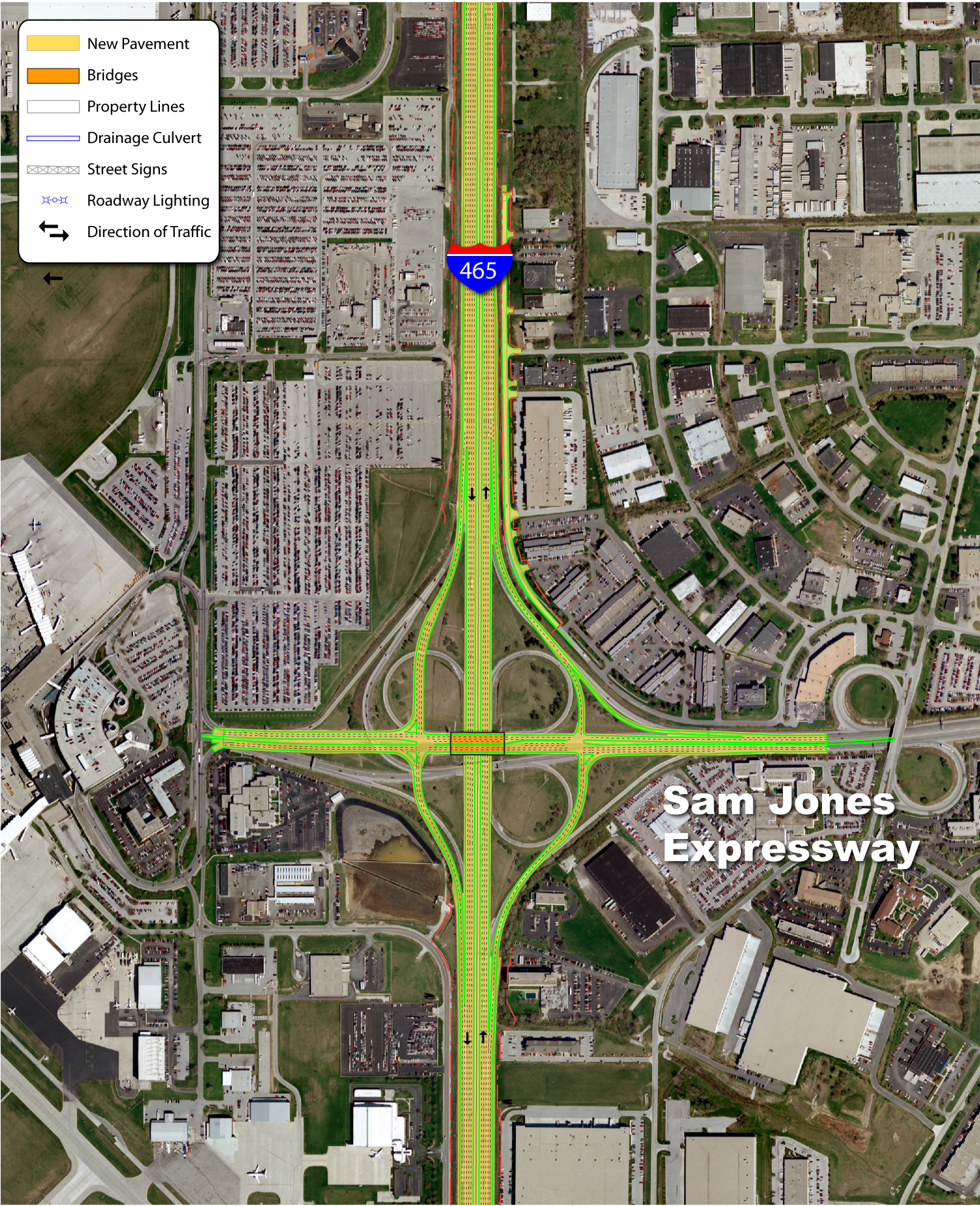
| Crossing over Washington Street and U.S. 40, I-74/465 advance one mile to Exit 11 for Sam Jones Expressway and 2.25 miles to Exits 9 B/A for Interstate 70. 06/25/22 |
|
| The Accelerate 465 project widened I-74/465 to twelve lanes along the section between Exits 12 and 11. Indianapolis International Airport (IND) lies west of the freeway and was originally accessed from the beltway before the construction of the Midfield passenger Terminal. 06/25/22 |
|
| The former directional cloverleaf interchange at Exit 11 was replaced with a diamond interchange as the role of Sam Jones Expressway was significantly reduced with the relocation of the Indianapolis International Airport (IND) passenger terminal from nearby to a point north of Exit 68 on Interstate 70. 06/25/22 |
|
| Formerly named Airport Expressway since it connected with the airport terminal, the limited access road was renamed in 2007 after Sam Jones, a local civic leader. The expressway provides a cut off from I-74/465 south to Interstate 70 east for Downtown Indianapolis. Raymond Street extends east from the expressway across the south side of Indianapolis. 06/25/22 |
|
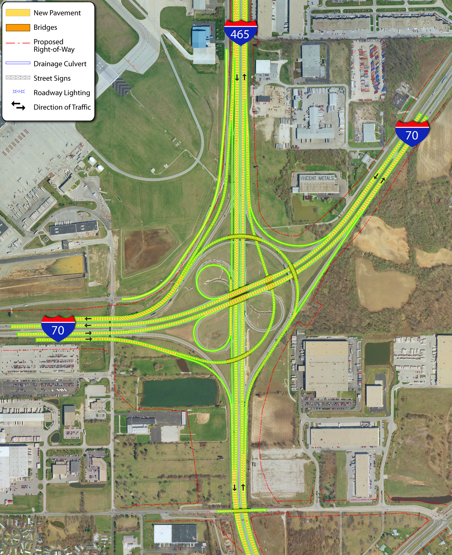
| Started in 2022, the I-69 Finish Line project includes widening Interstate 465 on the southwest side of Indianapolis to eight overall lanes. This work coincides with the I-465 Reconfiguration Project between I-70 and Mann Road and from U.S. 31 to I-65. 06/25/22 |
|
| Accelerate 465 reconstructed the original directional cloverleaf with I-70 into a half turbine interchange with flyover ramps linking I-70 east to I-74/465 north and I-74/465 north with I-70 west. 06/25/22 |
|
| Construction underway in the mid 2000s widened Interstate 70 between the Indianapolis Beltway and Ronald Reagan Parkway. This included realigning the freeway to accommodate expansion of Indianapolis International Airport (IND). 06/25/22 |
|
| Interstate 70 west joins Indianapolis with IND Airport and Terre Haute. Continuing beyond Indiana, I-70 travels to I-57 at Effingham, Illinois and St. Louis, Missouri. 06/25/22 |
|
| I-74/465 curve southeast from I-70 one mile to Exit 8 for Kentucky Avenue and SR 67 south. 06/25/22 |
|
| Interstate 70 angles northeast to Wayne before turning east to Downtown and an overlap with I-65. The orange overlay in 2022 referenced the closure of I-65/70 due to major reconstruction. 06/25/22 |
|
| I-74/465 arc southeast to a folded diamond interchange (Exit 8) with Kentucky Avenue and SR 67 south. SR 67 constitutes a 199.3 mile long route from Vincennes to SR 29. 06/25/22 |
|
| Canceled plans as part of the Accelerate 465 project were to tie in ramps from I-70 with Exit 8. 06/25/22 |
|
| Kentucky Avenue leads SR 67 from Exit 8 to the sprawling AmeriPlex office complex and through the southwest suburbs to Valley Mills and Mooresville. Kentucky Avenue east represents former SR 67 through Mars Hill and Maywood to Harding Street. 06/25/22 |
|
| Prior to the I-69 Finish Line project, I-74/465 reduced to six lanes across the south side of Indianapolis. 06/25/22 |
|
| I-69 Finish Line construction replaced the overpass for Mann Road at the half diamond interchange (Exit 7) with I-74/465. 06/25/22 |
|
| The entrance ramp from Thompson Road east and Mann Road joined I-74/465 east ahead of these confirming markers. 06/25/22 |
|
| I-74/465 continue east across the White River West Fork. 06/25/22 |
|
| I-74/465 travel between a rock quarry to the north and the Sunshine Gardens neighborhood to the south on the mile preceding Exit 4 to SR 37 south and Harding Street. 06/25/22 |
|
| Construction underway through Fall 2024 builds the final section of the Interstate 69 extension south to Evansville. Opened on August 6, 2024, the last portion was the connection with I-74/465 northwest from the original alignment of SR 37. 06/25/22 |
|
| The directional T interchange built along I-74/465 with Interstate 69 south includes extended ramps from Harding Street / Exit 4 to the east. 06/25/22 |
|
| The diamond interchange at Exit 4 connects I-74/465 with Harding Street (former SR 37). The construction of Interstate 69 directly replaced SR 37 south to Martinsville 06/25/22 |
|
| I-69/SR 37 travel southwest from Indianapolis to Waverly, Martinsville and Bloomington. 06/25/22 |
|
| There are two branches of State Road 37. The southern section runs north to Marion and south to Bloomington and Tell City. The northern leg travels between Fort Wayne and Ohio State Route 2 west of Hicksville. 06/25/22 |
|
| Several truck stops as well as motorist services for commuters to the south line Harding Street at I-75/465. Because of this the interchange at Exit 4 was rebuilt in 2011 to better handle traffic. 06/25/22 |
|
| Interstate 69 was initially constructed south of Indianapolis near Evansville in 2011. I-69 opened north to SR 37 in Bloomington in 2015 and along SR 37 to Martinsville in 2018. 06/25/22 |
|
| Harding Street north was slated to become the Harding Freeway in the 1968 Indianapolis Transportation Plan. The unbuilt route followed the existing surface road north to Oliver Avenue beyond I-70, and a planned alignment northwest to Interstate 65 and Kessler Boulevard. 06/25/22 |
|
| Harding Street intersects Thompson Road to the immediate south of the Indianapolis beltway. Prior to the completion of I-69, SR 37 transitioned onto the freeway in 1.1 miles. Bloomington is 43 miles away. 06/25/22 |
|
| SR 37 formerly combined with I-465/75 east from Exit 4 to Exit 2, where it followed East Street and old U.S. 31 north to Downtown Indianapolis. This shield assembly with a rare acknowledgement of an overlap with I-465 was a remnant from that previous route of SR 37. 12/17/11 |
|
| I-74/465 span Bluff Road one mile from Exit 2 A for U.S. 31 (East Street) south. Bluff Road represents the former alignment of SR 37 north to West Street and Downtown and south to Glenns Valley. 12/17/11 |
|
| Curving east ahead of Meridian Street, the roadways of I-74/465 separate with a wide median ahead of U.S. 31 / East Street at Exit 2. Travel time signs were added along the Indianapolis Beltway in 2011. 12/17/11 |
|
| A directional cloverleaf interchange (Exit 2) with left entrance ramps joins U.S. 31 / East Street with I-74/465 beyond Meridian Street (former SR 135). East Street carried U.S. 31 northward to Madison Avenue originally. Madison Avenue southeast to Homecroft, Southport and Greenwood was a part of the 1948 alignment of State Road 431. 12/17/11 |
|
| The University of Indianapolis can be reached by using Exit 2A and following East Street north to Hanna Avenue and east along Hanna. 12/17/11 |
|
| Exit 2 B leaves I-74/465 west for U.S. 31 (East Street) south to Greenwood. U.S. 31 accompanies the I-65 corridor south to Franklin, Columbus and Louisville, Kentucky. Lick Creek flows in the median of I-74/465 through the exchange with East Street. 12/17/11 |
|
| Exit 2 A loops onto East Street, which heads north to Madison Avenue and then into Downtown Indianapolis. 12/17/11 |
|
| Reassurance shields for I-465/74 east at the Madison Avenue (former SR 431 and U.S. 31) overpass. Lick Creek flows on the south side of the beltway here. 12/17/11 |
|
| Meeting the beltway at Exit 53 near Beech Grove, Interstate 65 travels 261.27 miles within Indiana. I-65 joins industrial Gary and the Chicagoland area with Lafayette, Indianapolis, Columbus, and Clarksville / Jeffersonville in the north Louisville metropolitan area. 12/17/11 |
|
| Interstate 65 travels 887 miles overall between Mobile, Alabama and Gary, Indiana. The route is a major trucking corridor between Chicago and Louisville. Further south the freeway undulates over low rise mountains and hills to Nashville, Birmingham and Montgomery, Alabama. 12/17/11 |
|
| Chronic traffic delays preceded major construction upgrading the directional cloverleaf interchange with I-65 into a cloverstack with flyover ramps. Mile zero for the Indianapolis beltway follows Exit 53 B for Interstate 65 south to Columbus and Seymour. 12/17/11 |
|
| Exit 53 A loops onto Interstate 65 north toward Downtown Indianapolis. The previous exchange included a left side entrance ramp from I-65 south. 10/16/04 |
|
| I-74/465 enter the city of Beech Grove ahead of Exit 52 with Emerson Avenue. Separating interests to the east from residential areas to the west, Emerson Avenue represents the main arterial from south to north through Beech Grove. 10/16/04 |
|
| I-465/74 eastbound reassurance markers posted prior to the expansion of the beltway to nine overall lanes between Interstate 65 and Exit 52 to Emerson Avenue. 10/16/04 |
|
| A single point urban interchange (SPUI) connects I-74/465 with Emerson Avenue in Beech Grove. Emerson Avenue leads north to Irvington and Sunnyview from central Beech Grove and south across Interstate 65 to Greenwood. 10/16/04 |
|
| East of Emerson Avenue / Exit 52, a travel time sign alerts motorists of the distance and estimated time to reach I-70 and I-69. As of late 2011, the signs were not yet operational. 12/17/11 |
|
| I-74/465 curve northeast toward their separation at Exit 49 and Five Points. Interstate 74 leaves the Indianapolis area for Shelbysville, Greensburg, and Cincinnati, Ohio. 10/16/04 |
|
| Southeastern Avenue (former U.S. 421) passes over I-465 where the collector distributor roadway (Exit 49) partitions for the continuation of I-74 east toward Wanamaker and Acton and unnumbered freeway spur west to Southeastern Avenue and Sunnyview. 10/16/04 |
Page Updated 07-14-2024.

 South
South  East
East


 North
North


