
Interstate 70 west of Business Loop I-70/SR 19 at Exit 164 in Green River, Utah. 07/04/16


 West
West  North
North
07/04/16

Interstate 70 and U.S. 6-50-191 travel 20 miles west from Crescent Junction to Green River. The next available services are along the Business Loop beyond Exit 164.
07/04/16

Hatch Mesa (el. 5,548 feet) appears northwest of I-70/U.S. 6-50-191.
07/04/16

The ranch exit for Floy joins Interstate 70 with Old Highway 6/50 west and Ruby Ranch Road south.
07/04/16

Ruby Ranch Road forms part of a loop with Ten Mile Road and Blue Hills Road south 21.44 miles to U.S. 191 by Canyonlands Field Airport (CNY).
07/04/16

Paralleling I-70 to the north, Old Highway 6/50 head 11.7 miles west from the diamond interchange at Exit 175 to Business Loop I-70 in Green River.
07/04/16

07/04/16

07/04/16

I-70 continues south of the Book Cliffs.
08/17/13

07/04/16

08/17/13

Advancing toward Green River and the Gunnison Valley along Interstate 70 west.
07/04/16

07/04/16

Little Elliott Mesa and Beckwith Plateau rise to the north of Green River.
08/07/13

08/07/13

Business Loop I-70/SR 19 loop north 4.58 miles into Green River from the ensuing exit.
07/04/16

A lodging area for Arches National Park, Green River is also home to Green River State Park and the River History Museum.
07/04/16

The next traveler services located just off Interstate 70 beyond Green River are in Salina, 110 miles to the west.
07/04/16

1.10 miles north from the diamond interchange (Exit 164) with I-70, Business Loop I-70/SR 19 overtakes old U.S. 6/50 west into Green River.
07/04/16

07/04/16

I-70 stays south of the Emery County and Green River city line west to mile marker 162.2.
10/18/04

The Union Pacific Railroad spans the Green River across a truss bridge to the north of I-70/U.S. 6-50-191 in Green River.
10/18/04

The second Green River exit is the diamond interchange with the west end of Business Loop I-70/SR 19 in three miles.
10/18/04

Beckwith Plateau north of Green River.
10/18/04

The Emery and Grand County lines originally followed the Green River across Interstate 70. Annexations from the city of Green River coincided with changes in the county border.
10/18/04

I-70/U.S. 6-50-191 curve northwest through Green River across Airport Road. Leaving the city limits ahead of Saleratus Wash, the freeway advances one mile to Exit 160.
10/18/04

The exchange (Exit 160) with Business Loop I-70/SR 19 (Main Street) east was constructed directly over the original alignment of U.S. 6/50. An abandoned roadbed stems northwest to parallel the UP Railroad.
10/18/04

Some services are available to motorists at the town of Emery, 68 miles to the west via I-70, Moore Cutoff Road and SR 10.
10/18/04

Exit 160 leaves Interstate 70 and U.S. 6-50-191 westbound for SR 19 (Main Street), 1.2 miles from Center Street in the Green River business district.
10/18/04

U.S. 6/191 north split with I-70/U.S. 50 at a trumpet interchange (Exit 157) in western reaches of Green River. U.S. 6 connects the I-70 corridor with Provo and Salt Lake City via I-15 north.
07/04/16

U.S. 6/191 angle northwest 52 miles to Wellington and 58 miles to Price. The U.S. 6 corridor between Green River and I-15 at Spanish Fork was designated as High Priority corridor 53 as part of the Safe, Accountable, Flexible, Efficient Transportation Equity Act: A Legacy for Users (SAFETEA-LU) in 2005.
07/04/16

U.S. 6/191 travel west of Beckwith Plateau and the Patmos Mountains northwest toward Price. U.S. 191 separates with U.S. 6 at Helper for U.S. 40 at Duchesne. U.S. 6 converges with U.S. 50 again west in the Sevier Desert at Delta.
07/04/16
West
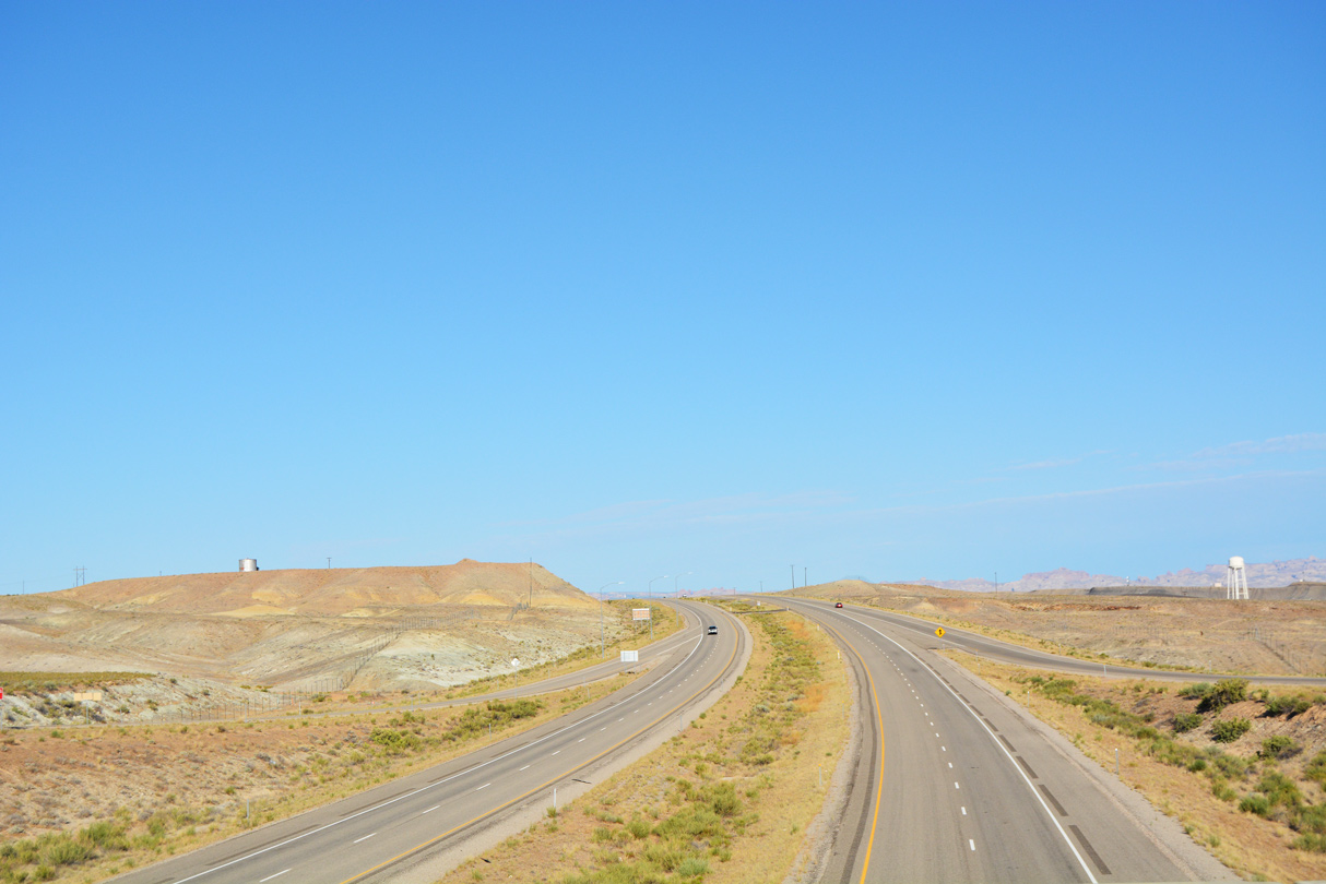
Interstate 70 continues southwest across the Gunnison Valley to San Rafael Reef, an unpopulated area of rocky crags, mesas and canyons.
07/15/17

The next population center along I-70/U.S. 50 west is the city of Salina, located 101 miles away. Interstate 70 was constructed along this stretch independent of any U.S. Highway.
07/15/17

07/15/17

08/17/13

I-70/U.S. 50 passes through a rock cut west ahead of Buckmaster Draw and San Rafael Reef.
08/17/13

Lowering west, I-70 advances toward the San Rafael River and Shadscale Mesa (el. 4,472 feet).
08/17/13

The east end of SR 24 ties into I-70/U.S. 50 at Exit 149 across from County Road 1029 north.
07/15/17

SR 24 ventures southwest across the San Rafael Desert to Goblin Valley State Park. Capitol Reef lies west of Hanksville along SR 24. SR 95 south from Hanksville to SR 226 leads to Glen Canyon National Recreation Area and Lake Powell.
07/15/17

Comprising a 160.51 mile long loop, SR 24 arcs west to Hanksville, Torrey, Loa and Sigurd to U.S. 50 at Salina.
07/15/17

Westbound I-70/U.S. 50 at the diamond interchange (Exit 149) with SR 24 west. CR 1029 (Four Corner Mines Road) zigzags northeast 11.60 miles back to U.S. 6/191 outside Green River.
07/15/17


Photo Credits:
10/18/04, 08/07/13, 08/17/13, 07/04/16, 07/15/17 by AARoads
Connect with:
Business Loop I-70 - Green River
U.S. 6
U.S. 50
U.S. 191
State Route 24
Page Updated 02-24-2022.