


 East
East
10/06/21

10/06/21

10/06/21

10/06/21

10/06/21

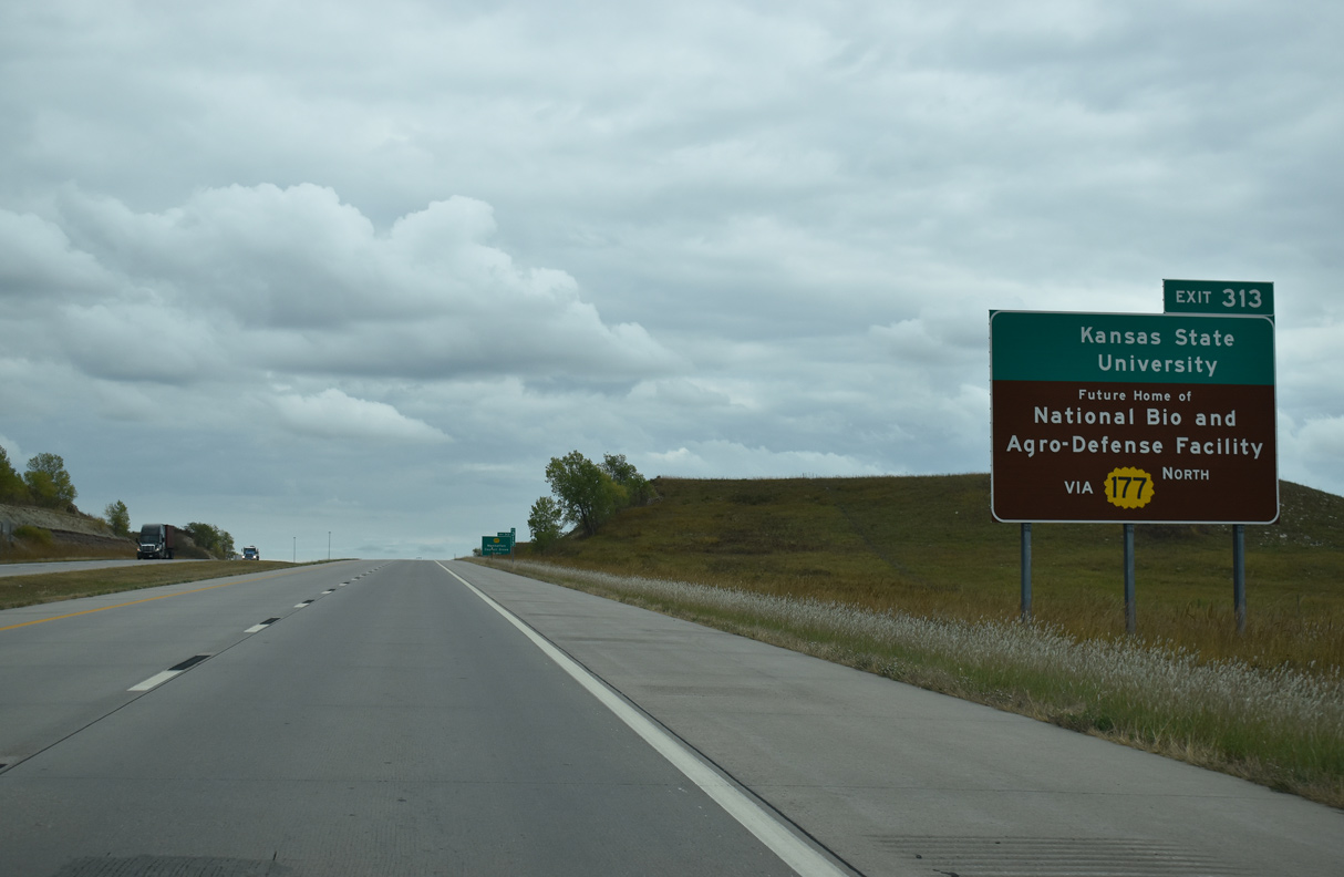
Originating in Manhattan at U.S. 24, K-177 travels 8.62 miles south along a four lane highway to I-70/U.S. 40 at Exit 313.
10/06/21
10/06/21

South fro Exit 313, K-117 continues 28.43 miles to U.S. 56 in the Morris County seat of Council Grove.
10/06/21

Tuttle Creek Lake lies north of Manhattan via K-177, U.S. 24 and K-13.
10/06/21

10/06/21

Measuring 102.87 miles overall, K-117 south concludes at U.S. 54 east of El Dorado.
10/06/21

10/06/21

10/06/21

10/06/21

10/06/21

10/06/21

I-70/U.S. 40 east enter Riley County within the folded diamond interchange (Exit 316) at Deep Creek Road.
10/06/21

10/06/21

10/06/21

10/06/21

10/06/21

10/06/21

10/06/21

10/06/21

Interstate 70 continues east into Wabaunsee County just ahead of the diamond interchange (Exit 322) with Tallgrass Road.
10/06/21

10/06/21

10/06/21

10/06/21

10/06/21

10/06/21

K-99 meets I-70/U.S. 40, 3.43 miles north from the city of Alma at Exit 328.
10/06/21

10/06/21

K-99 continues north over what was U.S. 40, 6.19 miles to the east end of K-18 near Wabaunsee and 9.33 miles to the Pottawatomie County line at Wamego.
10/06/21

K-99 south to Alma overlaid the original alignment of K-10. I-70/U.S. 40 east from Exit 328 was built directly over old K-10 toward Topeka.
10/06/21

10/06/21

10/06/21

10/06/21

K-185 constitutes a 0.65 mile long spur south from Exit 330 to the city of McFarland.
10/06/21

10/06/21

10/06/21

K-185 follows McFarland Road south from a parclo B2 interchange (Exit 330) with I-70/U.S. 70 to Main Street in McFarland.
10/06/21

10/06/21

10/06/21

10/06/21

10/06/21

K-333 branches east from I-70/U.S. 40 at Exit 333 to the city of Paxico.
10/06/21

10/06/21

K-138 spurs 1.09 miles east from the folded diamond interchange (Exit 333) with Grapevine Road to the Paxico city line by Kansas Avenue.
10/06/21

10/06/21

10/06/21

10/06/21

10/06/21

10/06/21

10/06/21

10/06/21

10/06/21

10/06/21

10/06/21

10/06/21

10/06/21

10/06/21

10/06/21

10/06/21

10/06/21

The parclo interchange at Exit 341 marks the south end of K-30, a 1.75 mile long spur to the city of Maple Hill.
10/06/21

10/06/21

10/06/21

10/06/21

10/06/21

10/06/21

10/06/21

10/06/21

10/06/21

10/06/21

10/06/21

10/06/21

10/06/21

10/06/21

10/06/21

10/06/21

10/06/21

I-70/U.S. 40 enter Shawnee County at the Carlson Road underpass by mile marker 345.
10/06/21


Photo Credits:
10/06/21 by AARoads
Connect with:
Highway 18
Highway 177
Page Updated 11-10-2021.