|
| I-57 travels 47.6 miles north from the west end of I-24 to the overlap with I-64 west at Mount Vernon. 04/05/13 |
|
| Forthcoming IL 148 branches northwest from parallel IL 37 to Energy and Herrin. 04/05/13 |
|
| Confirming marker posted north of the Day Road underpass. 04/05/13 |
|
| IL 148 comprises a 54.9 mile loop west from IL 37 near Pulleys Mill and Exit 45 to IL 37 and IL 142 in Mount Vernon. 04/05/13 |
|
| Entering the parclo B2 interchange (Exit 45) with IL 148 on Interstate 57 north. 04/05/13 |
|
| A 7.4 mile exit less stretch ensues north from the IL 148 entrance ramp to Exit 53 at Marion. 04/05/13 |
|
| A pair of weigh stations operate along Interstate 57 north of the exchange with IL 148. 04/05/13 |
|
| Mt. Vernon is 41 miles beyond the forthcoming city of Marion. Chicago is 326 miles away. 04/05/13 |
|
| Exit 53 with Main Street is the first of three interchanges in the city of Marion along I-57 north. 04/05/13 |
|
| Main Street joins Interstate 57 with Downtown Marion to the east. West of Exit 53, Marion Street is part of old IL 13. 04/05/13 |
|
| Exit 53 constitutes a folded diamond interchange with Main Street. IL 13 crosses I-57 at the succeeding exchange (Exit 54). 04/05/13 |
|
| IL13 is a major arterial route across the north side of Marion. The state route connects Marion with Carbondale and Murphysboro to the west and Harrisburg to the east. 04/05/13 |
|
| Construction underway in 2013 reconfigured the cloverleaf interchange (Exit 54) with IL 13 into a SPUI. 04/05/13 |
|
| A diverging diamond interchange (DDI) with The Hill Avenue was added to the immediate north of IL 13. 04/05/13 |
|
| Interstate 57 leaves Marion adjacent to IL 37 through Whiteash. 04/05/13 |
|
| Interstate 57 runs along the west side of Johnston City at Exit 59. 04/05/13 |
|
| Broadway Boulevard ties into the diamond interchange (Exit 59) with I-57 west from IL 13 (Grand Avenue) and the Johnston City center. 04/05/13 |
|
| Exit 59 leaves Interstate 57 north for Broadway Boulevard east and Herrin Road west to Paineville and the city of Herrin. 04/05/13 |
|
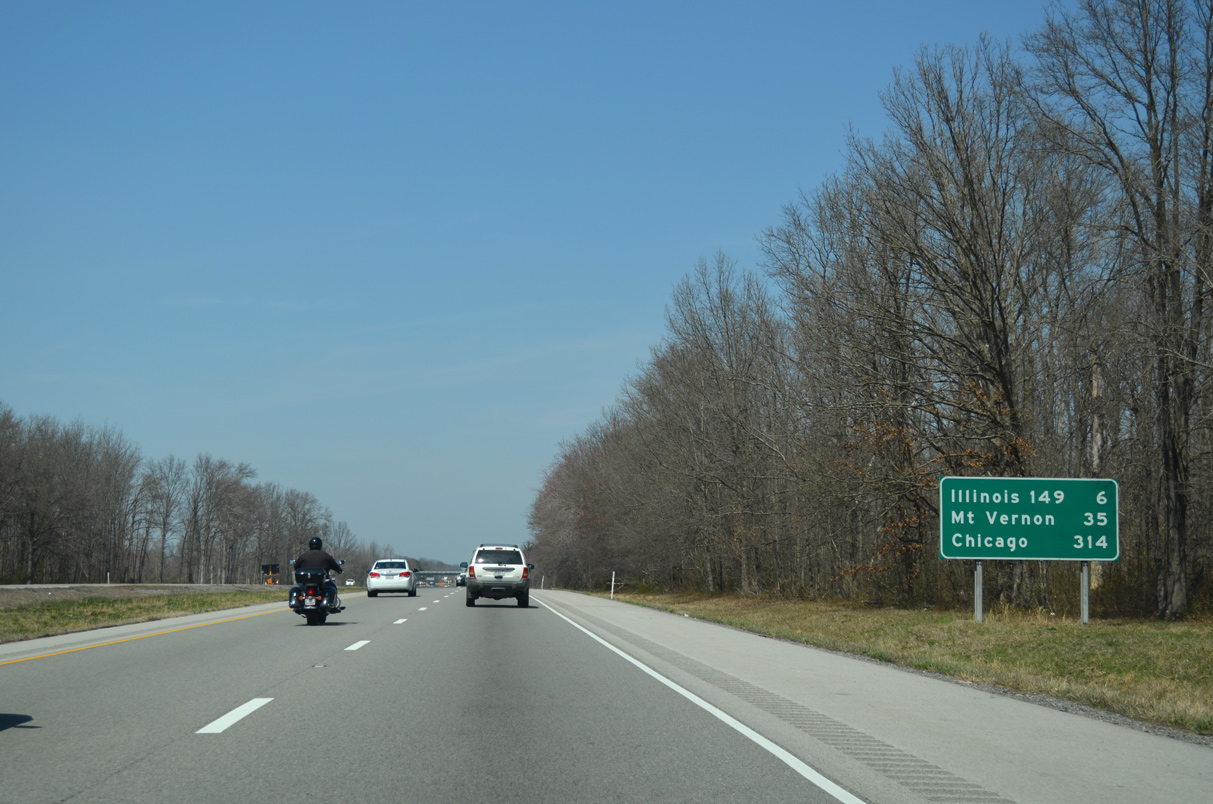
| Leaving Johnston City, Interstate 57 travels six miles to IL 149 in southern Franklin County. The IL 15 exit at Mt. Vernon is 35 miles to the north. 04/05/13 |
|
| Interstate 57 crosses into Franklin County southeast of the community of Pershing. 04/05/13 |
|
| I-57 next meets IL 149 (Main Street) at the city of West Frankfort. 04/05/13 |
|
| Illinois Route 149 travels 45.7 miles overall from IL 3 west of Murphysboro to IL 34 at Thompsonville. 04/05/13 |
|
| An abandoned Burlington Northern Railroad line spans Interstate 57 northbound ahead of the diamond interchange (Exit 65) with IL 149 (Main Street). 04/05/13 |
|
| Continuing north, I-57 shifts eastward across the Middle Fork of the Big Muddy River on the six mile drive to IL Route 14 at West City. Mt. Vernon is 29 miles away. 04/05/13 |
|
| I-57 reaches southwestern Benton at the Union Pacific Railroad underpass, one mile south of Exit 71 and Illinois Route 71. 04/05/13 |
|
| IL 14 measures 75.7 miles in length west from Exit 71 to Christopher and U.S. 51 south of Do Quoin and east to Mc Leansboro, Carmi and the Wabash River across from New Harmony, Indiana. 04/05/13 |
|
| The diamond interchange (Exit 71) with IL 14 (W Main Street) falls within the village of West City. Main Street leads IL 14 east to the Franklin County Courthouse at IL 37 (N/S Main Street) in Downtown Benton. 04/05/13 |
|
| Interstate 57 enters the Benton city limits east of Benton Municipal Airport (H96). 04/05/13 |
|
| Interstate 57 parallels IL 37 by northern reaches of the Benton city limits five miles to IL 154 at Exit 77. Chicago is 301 miles to the north. 04/05/13 |
|
| The Rend Lake Rest Area along Interstate 57 northbound follows the Petroff Road overpass. 04/05/13 |
|
| I-57 and adjacent IL 37 shift northeast from Benton Park to IL 154 and the unincorporated community of Whittington. 04/05/13 |
|
| One half mile ahead of the diamond interchange (Exit 77) with IL 154. IL 154 crosses an arm of Rend Lake to Wayne Fitzgerrell State Park nearby. 04/05/13 |
|
| Beginning from IL 37 adjacent to Exit 77, IL 154 extends 63.4 miles west to Sesser, Pinckneyville and IL 3/159 at Red Bud. 04/05/13 |
|
| Interstate 57 crosses the Gun Creek arm of Rend Lake north of Whittington. 04/05/13 |
|
| Passing Rend Lake College to the east, Interstate 57 enters southern Jefferson County. 04/05/13 |
|
| I-57 converges with the east side of Rend Lake from forthcoming Exit 83 northward to Bonnie. 04/05/13 |
|
| The diamond interchange (Exit 83) with North Avenue at Ina is the second exit for the adjacent reservoir. 04/05/13 |
|
| North Avenue connects the freeway with parallel Ken Gray Parkway and a boat ramp to the west and Oak Street in the village of Ina to the east. 04/05/13 |
|
| Interstate 57 continues eight miles north to meet I-64 east at Exit 92. 04/05/13 |
|
| Interstate 64 enters the outskirts of Mt. Vernon from Evansville, Indiana to the east. 04/05/13 |
|
| I-64 west combines with Interstate 57 north at a three-wye interchange (Exit 92) in one mile. 04/05/13 |
|
| Interstate 64 stretches across southern Illinois from the St. Louis area to the Wabash River near Grayville. The freeway heads east to Louisville, Kentucky and ultimately Hampton Roads in southeastern Virginia. 04/05/13 |
|
| Exit 92 departs I-57 north for I-64 east for rural Wayne and White Counties. I-57/64 combine for 4.1 miles north through Mount Vernon. 04/05/13 |
|
| I-57 north and I-64 west span IL 148 and a Union Pacific Railroad line beyond this shield assembly. The freeway was widened to six lanes by 2014. 04/05/13 |
|
| Opened in 2009, the forthcoming diamond interchange (Exit 94) joins I-57/64 with a westward extension of Veterans Memorial Drive from 42nd Street to Wells Bypass in Mt. Vernon. 05/27/11 |
|
| Veterans Memorial Drive leads directly to the intersection of IL 37 (10th Street) and the eastbound beginning of IL 142, a 55 mile route from Mt. Vernon to McLeansboro, Eldorado and Equality. 05/27/11 |
|
| Exit 94 departs I-57/I-64 north for Veterans Memorial Drive. The interchange was built to encourage economic development of the area. The arterial opened intially west to S 45th Street / Wells Bypass and was subsequently extended to Davidson Avenue. 04/05/13 |
|
| Next on I-57/64 north is the diamond interchange (Exit 95) with IL 15 (Broadway). IL 15 doubles as the original alignment of U.S. 460 leading west to Ashley, Nashville and Belleville. Historically U.S. 460 followed 10th Street (IL 37) south from Downtown Mt. Vernon to Perkins Avenue east, Shawnee Street south and IL 142 east. 04/05/13 |
|
| Replaced guide signs along I-57/64 north at IL 15 / Exit 95. 11/17/07 |
|
| Exit 95 leaves I-57/64 a mile and a half ahead of their north split. A 148 mile long highway, IL 15 travels nearly the width of southern Illinois between East St. Louis and the Indiana line at Mt. Carmel. Mt. Vernon Outland Airport (MVN) lies along the state route in east Mt. Vernon. 04/05/13 |
|
| A second set of confirming markers for I-57 north and I-64 west appears beyond the IL 15 on-ramp in western Mt. Vernon. 04/05/13 |
|
| Resuming a westward course, I-64 continues to O'Fallon and St. Louis. I-57 advances with two through lanes to Salem, Champaign and Chicago. 04/05/13 |
|
| Interstate 64 parts ways with I-57 north at a three-wye interchange (Exit 96). I-64 remains rural until Shiloh and the outer St. Louis suburbs while I-57 presses northeast 61 miles to converge with I-70 at Effingham. 05/27/11 |
Page Updated 12-30-2019.

 North
North


 West
West


