|
| The first of nine La Salle County interchanges along Interstate 39 joins the freeway with IL 18 at Lostant. The state route runs just north of the Marshall County line west from Exit 41 to the village of Magnolia and the Henry Bridge across the Illinois River. 08/10/09 |
|
| Exit 41 leaves Interstate 39 north for IL 18. A city of over 13,000, Streator lies 13 miles to the east along IL 18. 08/10/09 |
|
| Continuing north from IL 18, I-39/U.S. 51 pass just west of the Lostant village center. 08/10/09 |
|
| The exchange with Interstate 80 lies 16 miles to the north in the La Salle city limits. Rockford is 87 miles out. 08/10/09 |
|
| The village of Tonica is next along Interstate 39 at forthcoming Exit 48. 08/10/09 |
|
| A diamond interchange (Exit 48) joins I-39/U.S. 51 with County Road 54 (Ray Richardson Road) on the northwest side of Tonica. 08/10/09 |
|
| Exit 48 parts ways with I-39/U.S. 51 north for CR 54 west to Putnam County and east to IL 251 (1st Street) in Tonica and CR 14 east to Lowell. 08/10/09 |
|
| Progressing north from Tonica, Interstate 39 remains through agricultural areas to Oglesby. Rockford lies 80 miles to the north, where the freeway meets the Jane Addams Memorial Tollway (I-90). 08/10/09 |
|
| IL 71 extends 13 miles east from Interstate 180 at Hennepin to a diamond interchange (Exit 51) with I-39/U.S. 51. 08/10/09 |
|
| East from Exit 51, IL 71 combines with IL 351 for 3.3 miles north along Columbia Avenue through the city of Oglesby. 08/10/09 |
|
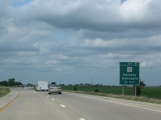
| Northbound at Exit 51 for IL 71 to Hennpin and Oglesby. IL 351 splits with IL 251 nearby as the original alignment of U.S. 51 through Oglesby, Piety Hill and La Salle. The state route passes under I-39 at the Abraham Lincoln Memorial Bridge. 08/10/09 |
|
| IL 251 angles northwest across I-39/U.S. 51 at the ensuing diamond interchange (Exit 52) after IL 71. 08/10/09 |
|
| IL 251 remains west of the Interstate 39 corridor through La Salle - Peru, Mendota, Rochelle and Rockford. 08/10/09 |
|
| Travelers along I-39/U.S. 51 north enter the I & M Canal National Heritage Corridor north at Oglesby. 05/09/10 |
|
| Entering the Oglesby city limits, Interstate 39 advances to within a half mile of the diamond interchange (Exit 54) with Walnut Street. 05/09/10 |
|
| Walnut Street leads east from I-39 directly to Downtown Oglesby. Points of interest for Exit 54 include Illinois Valley Community College (via CR 62 north) and Starved Rock State Park (via SR 71 east). 05/09/10 |
|
| Confirming markers for Interstate 39 and U.S. 51 posted at Piety Hill. 09/04/05 |
|
| North from Piety Hill and Jonesville, I-39/U.S. 51 shift east to bypass central La Salle to Exit 57 with U.S. 6. 05/09/10 |
|
| A 7,122 foot long tied arch span,1 the Abraham Lincoln Memorial Bridge carries Interstate 39 and U.S. 51 across the Illinois River into the city of La Salle. 09/04/05 |
|
| The Abraham Lincoln Memorial Bridge crosses over two ponds and a CN Railroad line preceding the Illinois River. 08/10/09 |
|
| I-39/U.S. 51 cross the Illinois River and the Iowa Interstate Railroad line west of Split Rock Lake. The Abraham Lincoln Memorial Bridge spans the river at a height of 66 feet with four lanes spread across a 82 foot wide deck.1 05/09/10, 08/10/09 |
|
| Reaching the bluff line north of the Illinois River, I-39/U.S. 51 north continue one quarter mile to a diamond interchange (Exit 57) with U.S. 6 08/10/09 |
|
| Interstate 39 through La Salle is the Tobias "Toby" Barry Highway. 08/10/09 |
|
| Paralleling the I-80 corridor across Illinois, U.S. 6 provides a local route west through Downtown La Salle and neighboring Peru and east to the village of North Utica. 08/10/09 |
|
| Trending eastward through La Salle, I-39/U.S. 51 next approach the cloverleaf interchange (Exits 59A/B) with Interstate 80. 05/09/10 |
|
| Forthcoming Interstate 80 runs across the north side of Peru, La Salle and North Utica as it connects the Quad Cities with the Chicago area. 05/09/10 |
|
| Exit 59A leaves I-39 north a half mile beyond the North 29th Road overpass. Interstate 80 parallels the Illinois River east to Ottawa, Morris and Joliet. The freeway passes through the south Chicago suburbs to Lansing and Hammond, Indiana. 05/09/10 |
|
| Interstate 80 travels 47 miles east to meet Interstate 55 outside Joliet. I-55 north provides the first of four Interstate connections to Chicago. 05/09/10 |
|
| Exit 59B loops away from I-39/U.S. 51 north for Interstate 80 west. I-80 navigates along a rural course west 70 miles to the Big X interchange with I-74 and I-280, the Quad Cities beltway. 05/09/10 |
|
| I-39/U.S. 51 advance 6.5 miles north from the I-80 westbound on-ramp to Exit 66 for U.S. 52 near the village of Troy Grove. 05/09/10 |
|
| The first rest area along Interstate 39 in Illinois is 24 miles north of I-80 in Lee County. 05/09/10 |
|
| Crossing Tomahawk Creek on I-39/U.S. 51 north of County Road 33. The bridges here were built in 1979. 08/10/09 |
|
| An eastward shift precedes the diamond interchange (Exit 66) joining I-39/U.S. 51 with U.S. 52. 08/10/09 |
|
| U.S. 52 is a rural route branching east from IL 251 through the nearby village of Troy Grove to Exit 66, Prairie Center and Serena in north La Salle County. 08/10/09 |
|
| Exit 66 leaves I-39/U.S. 51 north for U.S. 52. U.S. 52 travels nearly 216 miles across northern Illinois, heading east to Joliet and Kankakee and northwest to Dixon and the Dale Gardner Veterans Memorial Bridge across the Mississippi River at Savanna. 05/09/10 |
|
| The next population center along I-39/U.S. 51 north is the city of Mendota in five miles. The Ogle County city of Rochelle follows in 36 miles. 08/10/09, 05/09/10 |
|
| Signed here as the Little Vermilion River, I-39 crosses Little Vermilion Creek across a 1979-built bridge southwest of Triumph. 08/10/09 |
|
| A rural diamond interchange connects I-39/U.S. 51 with U.S. 34 on the east side of Mendota. 05/09/10 |
|
| U.S. 34 navigates along a stair stepped route east from Mendota to Meriden and the city of Earlville. 05/09/10 |
|
| Exit 72 leaves Interstate 39 north for U.S. 34. U.S. 34 travels 3.4 miles west to Downtown Mendota and nine miles east to Earlville. Overall through northern Illinois, U.S. 34 connects Burlington, Iowa and Galesburg with Naperville and Chicago. 05/09/10 |
|
| Reassurance shields for Interstate 39 and U.S. 39 preceding the BNSF Railroad underpass in east Mendota. 05/09/10 |
|
| The first of three Lee County interchanges lies 14 miles ahead with U.S. 30. Rockford is now less than an hour away. 05/09/10 |
|
| Travelers northbound on I-39/U.S. 51 enter Lee County at the Welland Road overpass. 08/10/09 |
Page Updated 04-30-2018.


 North
North


