|
| With traffic added from Interstate 94 west, the freeway expands to eight overall lanes to the cloverleaf interchange (Exits 135B/A) with U.S. 151. 06/13/15 |
|
| A half diamond interchange (Exit 135C) precedes the exchange with U.S. 151 for High Crossing Boulevard. High Crossing Boulevard constitutes a commercial arterial serving an auto mall and an assortment of big box retail in Madison Crossing and East Town Plaza shopping centers. 06/13/15 |
|
| A lane drop occurs in half mile for the collector distributor roadways leading to U.S. 151 north (Exit 135A) for the suburb of Sun Prairie and U.S. 151 south (Exit 135B) along Washington Avenue to the State Capitol. 05/30/11 |
|
| Wisconsin Dells remains the control point leading north from Madison. Two lanes part ways for U.S. 151 (Washington Avenue) and High Crossing Boulevard. U.S. 151 angles northeast from Dubuque, Iowa to Manitowoc along a 220.27 mile route across the state. 06/13/15 |
|
| Exit 135C was added to the U.S. 151 interchange in 2003 to serve additional development in the East Towne Mall area. The 1971-opened mall is located southwest of I-39-90-94 along U.S. 151 (Washington Avenue).1 05/30/11 |
|
| U.S. 151 upgrades to a freeway from I-39-90-94 northeast by the American Family Insurance headquarters and the 447 acre The American Center Business Park through the city of Sun Prairie. The US highway varies between freeway and expressway northeast to Beaver Dam, Waupun and Fond du Lac. 06/13/15 |
|
| A loop ramp joins I-39-90-94 north with U.S. 151 as it transitions into a busy commercial arterial (Washington Avenue) southwest by the Bluff Acres neighborhood and East Towne Mall. U.S. 151 leads southwest through the city toward Downtown to combine with the freeway along U.S. 12/18 at Burr Oaks. 06/13/15 |
|
| The six lane freeway passes between the Bluff Acres neighborhood and The American Center Business Park south of Hanson Road. 06/13/15 |
|
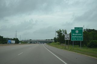
| U.S. 51 (Stoughton Road) heads north from U.S. 151 and the Westchester Gardens neighborhood through north Madison to cross paths with I-39-90-94 in 1.75 miles. The US route parallels I-39 north to Portage. 06/13/15 |
|
| A six-ramp parclo interchange (Exit 132) joins the Interstate with U.S. 51 north of Dane County Regional Airport (MSN). The US highway forms a freeway leading north through DeForest and the November 2015-formed village of Windsor. WisDOT directly upgraded the two lane road into a limited access highway as part of a two phase construction project between 2012 and 2014. A freeway option was selected due to high volume of traffic on side roads intersecting U.S. 51.2 06/13/15 |
|
| I-39-90-94 west approach a modified diamond interchange (Exit 131) with Wis 19 at Windsor. 06/13/15 |
|
| A number of industrial parks line the east side of the freeway both before and after the upcoming ramps with Wis 19. 06/13/15 |
|
| Wis 19 connects I-39-90-94 with Waunakee to the west and Sun Prairie to the east as part of a 59 mile route between U.S. 14/Wis 78 near Mazomanie and Wis 16 in Watertown. 06/13/15 |
|
| Interstates 39-90-94 straddle western reaches of Windsor and Lake Windsor Country Club over the next two miles. 06/13/15 |
|
| Portage lies 26 miles to the north via Interstate 39 while I-90/94 west reach Wisconsin Dells in 44 miles. 06/13/15 |
|
| County V (North Street) provides the main exit from I-39-90-94 into the village of DeForest. The county trunk highway runs north of the village center to a dumbbell interchange with U.S. 51, where it was realigned to bypass a one mile concurrency with the US route. 06/13/15 |
|
| West from the diamond interchange (Exit 126) with I-39-90-94, CTH-V travels 4.3 miles through Norway Grove to end at STH-113 outside the village of Dane. 06/13/15 |
|
| County I stems north from County V to pass over I-39-90-94 en route to the village of Arlington. 06/13/15 |
|
| A 6.7 mile long exit less stretch concludes at Wis 60 in the town of Arlington. Wausau, the north end of Interstate 39, debuts on distance signs at 126 miles. 06/13/15 |
|
| A long straight away across agricultural areas takes the freeway northwest into Columbia County. 06/13/15 |
|
| A pair of 1,150 foot hills frame the County K overpass in this northbound scene. 06/13/15 |
|
| Wis 60, a cross state route stretching 185 miles from Prairie du Chien to I-43 at Grafton, crosses paths with the freeway in one mile. 06/13/15 |
|
| The city of Lodi lies four miles to the west of Exit 119 via STH-60. The trunk highway ventures east from I-39-90-94, 3.5 miles to Arlington. 06/13/15 |
|
| Confirming shields posted north of the parclo B2 interchange with Wis 60. 06/13/15 |
|
| Highway CS is the lone interchange ahead of the split with I-39 for Portage. Wis Dells is a half hour away via I-90/94 west. 06/13/15 |
|
| The terrain becomes vastly more hilly as I-39-90-94 approach the Wisconsin River valley. Forthcoming County CS meets the freeway at the second parclo B2 interchange (Exit 115) in Columbia County. 06/13/15 |
|
| CTH-CS meanders east four miles to the Poynette village center. West from Exit 115, the trunk highway continues to CTH-V at Lake Wisconsin. Lake Wisconsin is a 9,500 acre reservoir formed by the Prairie du Sac Dam. Built between 1911 and 1914, the dam impounds water to a depth of 40 feet and is part of a system of reservoirs along the Wisconsin River. 06/13/15 |
|
| The 29 mile overlap between I-39-90-94, the longest three-way overlap in the Interstate system, concludes 6.4 miles beyond this shield assembly. 06/13/15 |
|
| A pair of rest areas are located along I-39-90-94 in 1.5 miles. This facility is just the second for I-39 north / I-90 west since entering the state, as two other areas were closed. 06/13/15 |
|
| The Black Road overpass precedes the Poynette rest area. The facility accommodates 138 car and 63 truck parking stalls and is home to a Frank Lloyd Wright "Prairie Style" inspired building. 06/13/15 |
|
| The South Range, Townhall Hill and Cascade Mountain rise to the north as drivers leave the rest area across an area of wetlands associated with the Wisconsin River. 06/13/15 |
|
| Three miles remain before Interstate 39 separates from I-90/94. The split occurs at the north end of Wis 78. Wausau is a 111 miles further along I-39/U.S. 51 north. 06/13/15 |
|
| Interstates 39-90-94 lower to cross the Wisconsin River just west of St. Lawrence Bluff, which rises over 150 feet above the waters edge. Gusty winds are a periodic hazard at the crossing. 06/13/15 |
|
| The Wisconsin River is the longest river within the state. Flowing 430 miles south from Lac Vieux Desert near the Michigan state line, the waterway empties into the Mississippi River south of Prairie du Chien. 06/13/15 |
|
| The Wisconsin River bridge was built between 1959 and 1961. The span travels approximately 31 feet above the river and is 1,690 feet long.1 06/13/15 |
|
| Looking northeast at the Wisconsin River at midspan toward Dekorra. 06/13/15 |
|
| I-39-90-94 west emerge from the Wisconsin River valley across a flat area of agricultural land two miles ahead of the directional cloverleaf interchange (Exits 108B/A) with Wis 78. 06/13/15 |
|
| Interstate 39 replaced Wis 78 north to U.S. 51 at Portage when it was extended to Wausau. Wis 78 forms a multi state route with IL 78 totaling 308 miles south to Gratiot and Jacksonville, Illinois. 06/13/15 |
|
| A parclo A2 interchange at Wis 78 was previously upgraded to include directional ramps for Interstate 39 leading north to Plover and Stevens Point. U.S. 51 accompanies the freeway from Portage north to Wausau and ultimately Merrill. 06/13/15 |
|
| I-90/94 west circle around Cascade Mountain through and beyond the split with Interstate 39 north. Wis 78 takes a stair stepped route along the South Range 12 miles southwest to Merrimac along Lake Wisconsin. 06/13/15 |
|
| A two lane ramp (Exits 108B/A) parts ways with I-90/94 west as the freeway reduces to four overall lanes to Wis Dells. I-39 extends another 103 miles to Wis 29 in Wausau while I-90/94 overlap for another 63.4 miles to Monroe County. 06/13/15 |
|
| The distributor roadway for Exit 108 separates with two lanes for I-39 north to Portage and Wis 78 south to Sauk City. While I-39 was designated in the state on October 16, 1992, signs for the route were not posted until 1996 from Portage to Rothschild.3 06/13/15 |
Page Updated 04-28-2016.


 North
North 
 West
West


