
 West
West
Located within Coronado National Forest, the Whetstone Mountains appear to the southwest.
04/25/17

04/25/17

San Pedro Valley spreads into view along Interstate 10 west near the Union Pacific Railroad siding of Fenner.
04/25/17

04/25/17

The third business loop from I-10 west in Arizona line 4th Street west from Pomerene Road and Exit 306 to Downtown Benson.
04/25/17

SR 80 stems south from Benson to Douglas, Bisbee and Tombstone. SR 80 is former U.S. 80, which was decommissioned in 1991.
04/25/17

Once a major shipping point for the mines located south of the town, Benson is named for an early peddler. The city today the railroad and travel drive the local economy.
04/25/17
Once a major shipping point for the mines located south of the town, Benson is named for an early peddler. The city today the railroad and travel drive the local economy.
04/25/17

I-10 runs alongside E 4th Street and the Union Pacific Railroad leading into the diamond interchange (Exit 306) with Business Loop I-10 and Pomerene Road.
04/25/17

Pomerene Road extends north from Business Loop I-10 to the community of Pomerene along the San Pedro River.
04/25/17

Crossing the San Pedro River along Interstate 10 west. The San Pedro River is unique in that it is the last remaining undammed river in Arizona. Additionally, several attempts were made to use the river valley as a transportation corridor. These included the cancelled SR 176.
04/25/17

04/25/17

Interstate 10 arcs northward to circumvent the Benson street grid ahead of the diamond interchange (Exit 304) with Ocotillo Avenue.
04/25/17
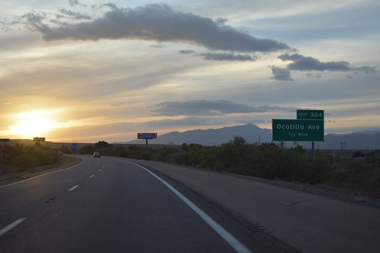
Ocotillo Avenue heads 0.60 miles south to Business Loop I-10/Historic U.S. 80 (4th Street) at Butterfield Plaza shopping center.
04/25/17

Ocotillo Avenue parallels the San Pedro River north to Cornfield Canyon and Willow Lake.
04/25/17

Curving southwest, Interstate 10 spans the Union Pacific Railroad beyond this confirming marker.
04/25/17

Business Loop I-10 returns to I-10 two miles ahead of the diamond interchange (Exit 302) with the west end of SR 90.
04/25/17

SR 90 constitutes a 46.77 mile long highway west from SR 80 to Sierra Vista and north through Huachuca City to I-10 in west Benson.
04/25/17

04/25/17

SR 90 leads south to Kartchner Caverns State Park, SR 82 at Whestone and Fort Huachuca Military Reservation by the city of Sierra Vista.
04/25/17

The Little Rincon and Rincon Mountains rise west of San Pedro Valley and northwest of Benson.
04/25/17

Interstate 10 previously made an S-curve just west of SR 90 over a former Southern Pacific Railroad line. This was straightened out in 2011/12 road construction.
04/25/17

Interstate 10 continues 41 miles west from Benson to I-19 at South Tucson and 43 miles to Downtown Tucson.
04/25/17

The succeeding exit along Interstate 10 west is for Skyline Road.
04/25/17

Exit 299 connects to Skyline Road, the north side frontage road for I-10, and to Smith Ranch Road, which leads south to Smith Ranch.
04/25/17

The diamond interchange (Exit 299) at Skyline Road lies just east of Cornfield Canyon.
04/25/17

04/25/17

J-Six Ranch Road north and Mescal Road south converge at a diamond interchange (Exit 297) with Interstate 10 in one mile.
04/25/17

J-Six Ranch Road leads south into the Thunderbird Trail development, but ends before reaching the Coronado National Forest boundary.
04/25/17

Mescal Road leads north past Mescal and the Union Pacific Railroad tracks before reaching the Coronado National Forest.
04/25/17

The next available gas station along Interstate 10 west from Mescal is not for 19 miles.
04/25/17

04/25/17

I-10 west departs Cochise County and enters Pima County, home to the city of Tucson. The second most populous county in Arizona, much of Pima County in the vicinity of Tucson has been developed. However, great tracts of the desert are protected, including Saguaro National Park and Ironwood Forest National Monument.
04/25/17

Shifting north, the first exit in Pima County links Interstate 10 with Empirita Road, which leads south to provide local and ranch access.
04/25/17

Entering the folded diamond interchange (Exit 292) with Empirita Road on I-10 west. Empirita Road does not connect to any other major roads.
04/25/17

Interstate 10 crosses Union Pacific Railroad tracks between Exit 292 and the site of a former rest area.
04/25/17

Eliminating a 1955 overpass adjacent to Cienega Creek, road work from 2006 to 2010 realigned the UP Railroad to parallel the north side of I-10. Construction also extended Marsh Station Road 1.69 miles east to a diamond interchange built at Exit 291.
04/25/17

Marsh Station Road is the old alignment for U.S. 80 west from the former exchange at Exit 289, 9.23 miles to Exit 281.
04/25/17

The exchange at Exit 291 replaced a set of right in right out (RIRO) ramps with Marsh Station Road further west.
04/25/17

04/25/17

04/25/17
04/25/17

I-10 traverses a series of hills south of Cienega Creek Natural Preserve over the ensuing stretch west.
04/25/17

Crossing Davidson Canyon.
04/25/17

Bending northward, the next exit along westbound I-10 is for SR 83 south to Sonoita and Patagonia. Marsh Station Road/Old U.S. 80 rejoins the freeway at the forthcoming trumpet interchange (Exit 281).
04/25/17

A scenic route, SR 83 passes by the eastern edge of the Santa Rita Experimental Range and Wildlife Area. SR 82, which heads southwest toward Nogales, continues the scenic route as it enters the Coronado National Forest en route toward the International border.
04/25/17

SR 83 travels 53.41 miles from Exit 281 south to S Parker Canyon Road to Parker Canyon Lake.
04/25/17

Exit 281 loops onto SR 83 south at the unincorporated community of Vail.
04/25/17

Sonoita lies 25.5 miles south of Interstate 10 beyond Davidson Canyon, the Empire Mountains and Santa Rita Mountains.
11/10/07

04/25/17

Angling northwest, the succeeding exit is for Wentworth Road south and Colossal Cave Road north at Vail.
04/25/17

Colossal Cave Mountain Park, located 7.5 miles northeast of Exit 279, was discovered in 1879 but had been in use by the Hohokam Indians centuries prior to that. Tours of the cave are available, and the temperature is 70 degrees (not 100 plus as is typical in the Summer).
04/25/17

Colossal Cave Road heads north to Mary Ann Cleveland Way at the Rancho del Lago Golf Course Community. Mary Ann Cleveland Way replaced Vail Road northwest to the Rita Ranch master planned community. Wentworth Road extends 5.59 miles south to Sahuarita Road.
04/25/17

Interstate 10 continues northwest from Exit 279 into the city of Tucson. I-10 skirts much of the city to the south, and there is no cross freeway to reach northern areas of the 1,000,000 million plus metropolitan area.
04/25/17

The Crossings interchange where I-10 converges with the north end of I-19 is 18 miles to the northwest. Downtown Tucson follows three miles beyond that exchange.
04/25/17

Continuing northwest across Tucson, interchange sequence signs are regularly posted.
04/25/17

Houghton Road heads north from the Pima County Fairgrounds and Tucson Speedway to meet Interstate 10 at a diverging diamond interchange (Exit 275).
04/25/17

Houghton Road north connects to Old Vail Road and Valencia Road at Rita Ranch and the Tanque Verde northeast of Tucson. Escalante Road stems east from Hougton Road toward the eastern unit of Saguaro National Park; Catalina Highway northeast connects to Mount Lemmon Highway. Mount Lemmon (el. 9,157 feet) features a ski area, campground and hiking trails.
04/25/17

Houghton Road continues 6.78 miles south from the DDI at Exit 275 to Sahuarita Road at the Corona De Tucson community.
04/25/17

04/25/17

Advancing northwest, I-10 meets S Rita Road at a diamond interchange (Exit 273) in one mile.
04/25/17

04/25/17

Rita Road 5.33 miles loops northeast to UA Tech Park at Rita Road and through the Rita Ranch development to Houghton Road.
04/25/17

04/25/17

Continuing northwest, I-10 passes by the Trails West manufactured home community, Voyager RV Resort and Sycamore Park development to Exit 270 with Kolb Road.
04/25/17

Kolb Road and Wilmot Road both lead north to Davis-Monthan Air Force Base.
04/25/17

Beyond Davis-Monthan Air Force Base, Kolb Road proceeds north through suburban Tucson to Speedway Boulevard, and along Pantano Wash to become Grant Road west.
04/25/17

Photo Credits:
11/10/07, 04/25/17 by AARoads
Connect with:
Business Loop I-10 - Benson
State Route 80 / Historic U.S. 80
State Route 83
Page Updated 04-13-2022.