
 East
East  South
South
Interstate 10 east enters the Grand Canyon State midway across the Colorado River.
07/07/18

Commercial vehicles are restricted from using Exit 1 and instead must proceed east to the Port of Entry in three miles.
07/07/18

Exit 1 departs from I-10 east / U.S. 95 south for Ehrenberg and Parker.
07/07/18

The Arizona welcome sign stands within the exchange at Exit 1.
03/02/19

The diamond interchange (Exit 1) with Juneau Avenue north was rebuilt by 2015 with a five leg roundabout added connecting the eastbound ramps and S Frontage Road.
07/07/18

07/07/18

07/07/18

Commercial vehicles are directed into the right lane ahead of Cinnabar Wash in preparation for the Port of Entry.
07/07/18

Due to the high volume of trucks, no lane changes are permitted until after the Port of Entry.
03/02/19

All commercial vehicles with agricultural products must exit at the Port of Entry.
07/07/18

The truck weigh station lies just east of milepost 3.
03/02/19

Lane restrictions for Interstate 10 east end beyond the port of entry.
03/02/19

I-10/U.S. 95 advance two miles east to Exit 5 for Tom Wells Road.
03/02/19

The Ehrenberg Rest Area follows along Interstate 10 east.
03/02/19

The succeeding rest area is located 48 miles away, not 40 miles as indicated here, which is Exit 45 for Vicksburg Road.
03/02/19

The diamond interchange at Exit 5 joins I-10/U.S. 95 with Tom Wells Road and Morgan Drive.
07/07/18

07/07/18

A half mile north of the nearby truck stop by Exit 5 is an original section of U.S. 60-70.
07/07/18

07/07/18

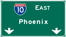
Advancing east, Interstate 10 reaches Quartzsite in 12 miles and Phoenix in 140 miles.
07/07/18

07/07/18

I-10/U.S. 95 ascend into the Dome Rock Mountains by Farrar Gulch.
07/07/18

07/07/18

07/07/18

The modified diamond interchange at Exit 11 joins I-10/U.S. 95 east with Dome Rock Road in one mile.
07/07/18

The historic alignment of U.S. 60/70, Dome Rock Road branches southward from Exit 11 past Sugarloaf Peak to Granite Mountain and Quartzsite. A bridge taking from 1938 spans La Cholla Wash along the route.
07/07/18

07/07/18

Distance sign posted five miles west of Quartzsite and 39 miles from the succeeding Rest Area. Phoenix is less than two hours away.
07/07/18

U.S. 95 separates from Interstate 10 east at the town of Quartzsite to accompany Business Loop I-10 (Main Street) to SR 95 (Central Boulevard).
07/07/18

Business Loop I-10 overlays part of old U.S. 60/70 on Main Street along a 2.94 mile long course between Exit 17 and 19.
03/02/19

U.S. 95 travels 104.25 miles south from Main Street in Quartzsite to Yuma and San Luis along the International border.
03/02/19

SR 95 heads north from Quartzsite 92.80 miles to Parker, Lake Havasu City and Interstate 40 east of Topock.
03/02/19

U.S. 95/Business Loop I-10 along W Main Street is locally maintained for 1.41 miles between Quartzsite Avenue north from Exit 17 to SR 95 and Central Boulevard.
07/07/18
East
Built in 1964, the pedestrian bridge spanning Interstate 10 at Walkover Road was constructed to serve the snowbird population that settles in Quartzsite every Winter. Numerous RV parks populate the town.
03/02/19

U.S. 95 (Central Boulevard) spans Interstate 10 less than a mile west of the diamond interchange (Exit 19) with Riggles Avenue and the end of Business Loop 10.
03/02/19

Business Loop I-10 turns west onto E Main Street (former U.S. 60/70) back into Quartzsite from Riggles Avenue just north of Exit 19.
03/02/19

Travel services at Exit 19 are the last along Interstate 10 for the next 26 miles.
03/02/19

03/02/19

Interstate 10 gains around 900 feet in elevation from Quartzsite and La Posa Plain on the ten miles leading to U.S. 60 at Exit 31.
06/28/08

Entering the Plomosa Mountains, Interstate 10 next meets Gold Nugget Road at a diamond interchange (Exit 26).
03/02/19

Gold Nugget Road east from Exit 26 along the north side of Guadalupe Mountain is former U.S. 60/70.
03/02/19

03/02/19

Interstate 10 continues across the Plomosa Mountains four miles to the eastbound beginning of U.S. 60.
03/02/19

Circumventing Guadalupe Peak, Interstate 10 crosses Plomosa Pass.
06/28/08

U.S. 60 branches 55.43 miles northeast from Interstate 10 to SR 71 and 79.81 miles to U.S. 93 in Wickenburg.
03/02/19

U.S. 60 was formerly the through route to Phoenix. While it can still be used that way, it was superseded by Interstate 10, routed along what was called the Brenda cut-off by original planners.
03/02/19

The trumpet interchange at Exit 31 marks the west end of U.S. 60. U.S. 60 stretches 2,655 miles across the country to Virginia Beach, Virginia.
03/02/19

03/02/19

A 14 mile long exit less stretch takes Interstate 10 east across Ranegras Plain to Vicksburg Road. SR 85, a major route south to I-8 at Gila Bend, connects with I-10 in 80 miles at Buckeye.
03/02/19

Interstate 10 passes south of the Bear Hills between mile markers 36 and 40.
03/02/19

Vicksburg Road stems 6.18 miles north from the diamond interchange at Exit 45 to U.S. 60 and 8.30 miles to SR 72 at Vicksburg.
03/02/19

03/02/19

03/02/19

03/02/19

Interstate 10 plies across Upper Bouse Wash on the six miles leading to the Bouse Wash Rest Area. Phoenix is 100 miles away.
03/02/19

The Bouse Wash Rest Area is the second of three facilities along Interstate 10 between Blythe, California and Phoenix.
03/02/19

The Bouse Wash Rest Area along both directions of I-10 closed on June 7, 2021 for a modernization project. The parking lots were also expanded during work through early 2022.1
03/02/19

Exit 53 links I-10 with Hovatter Road east of the Little Harquahala Mountains.
03/02/19

Hovatter Road ties into Interstate 10 in a remote area northeast of Black Rock Hill.
03/02/19

I-10 spans the Hayden-Rhodes Aqueduct just beyond the exchange with Hovatter Road. Originating at Parker Dam, the Central Arizona Project Canal rises approximately 2,000 feet in elevation from the Colorado River along a course east to Phoenix and Tucson.
03/02/19

The Burnt Well Rest Area lies 33 miles ahead, followed by SR 85 south in 58 miles.
03/02/19

Interstate 10 traverses wide open desert across Harquahala Plain.
03/02/19

Topopah, a small settlement at Exit 94, is 32 miles to the southeast. Phoenix is 84 miles away.
03/02/19

Burnt Mountain rises far to the southeast from mile marker 66.
03/02/19

Avenue 75E meets Interstate 10 at a diamond interchange (Exit 69) in one mile.
03/02/19

03/02/19

03/02/19

Interstate 10 enters Maricopa County 70.78 miles east from the California state line.
03/02/19
Sources:
- "I-10 Bouse Wash Rest Area to close June 7 for renovations." Arizona Department of Transportation (ADOT), news release. June 3, 2021.
Photo Credits:
06/28/08, 07/07/18, 03/02/19 by AARoads
Connect with:
Business Loop I-10 - Quartzsite
U.S. 60
U.S. 95
State Route 95
Page Updated 04-07-2022.