|
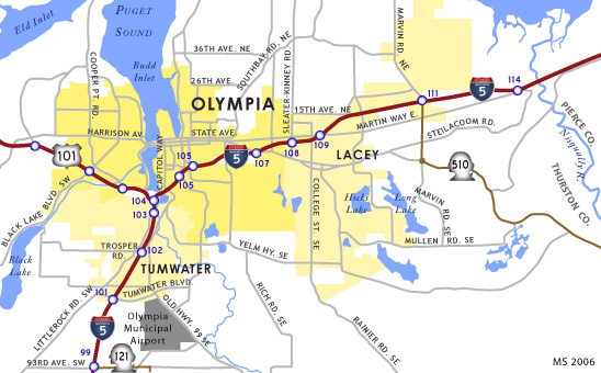
| The South Sound Speedway can be reached by taking exit 88. Follow Pacific Highway northeast from the exit about two miles; the speedway sits at the intersection with 183rd Avenue SW. 10/29/05 |
|
| Exits 88A and 88B are next up. Advance signs on the approach to the interchange show destination points: the cities of Aberdeen, Tenino, Rochester and Oakville. A single interchange handles traffic for both exits 88A and 88B; separate ramps, one before the overpass, and one after, ferry traffic for each. 10/29/05 |
|
| Exit 88A is primarily for eastbound traffic headed for Tenino on the old Pacific Highway. Tenino is situated at the junction of Pacific Highway SE and SR 507 (which departed Interstate 5 back at exit 81). 10/29/05 |
|
| U.S. 12 departs from northbound I-5 at Exit 88B for the Washington Coast and the towns of Rochester, Montesano, Aberdeen, and Hoquiam. 10/29/05 |
|
| Northbound I-5 is still two lanes at this point, but it will soon widen to three. 10/29/05 |
|
| The 183rd Ave. overpass holds a distance sign for Tumwater, Olympia, and Seattle, as well as a 2 mile advance sign for the next rest area. 10/29/05 |
|
| The Scatter Creek rest area lies about 14 miles south of Olympia and is a good place to stop to catch your breath before venturing into the heavy traffic of the Puget Sound population belt. 10/29/05 |
|
| A one mile advance sign announces the next exit: exit 95, SR 121, Littlerock and Maytown. Millerslyvania State Park (sign, second image) lies along SR 121. 10/29/05 |
|
| State Route 121 is a short highway that heads east through Maytown and then turns north past Millersylvania State Park, returning to the freeway at Exit 99. West of Exit 95, Maytown Road intersects with Littlerock Road SW. 10/29/05 |
|
| Past exit 95, northbound Interstate 5 widens to three lanes. 10/29/05 |
|
| A one mile advance sign heralds upcoming exit 99: SR-121 southbound, 93rd Ave. and Scott Lake. 10/29/05 |
|
| Washington State Route 121 returns to I-5 at Exit 99. SR 121 east (93rd Avenue SW) to Case Road SW leads toward Scott Lake. West of the freeway, 93rd Avenue SW intersects Littlerock Road 10/29/05 |
|
| At milepost 100, this sign announces the three Tumwater exits: Tumwater Boulevard, Trosper Road, and Deschutes Way. 10/29/05 |
|
| Northbound Interstate 5 encounters a one half mile advance sign for the first Tumwater exit, Tumwater Boulevard (Exit 101). Incorporated in 1869, Tumwater, whose name comes from Chinook jargon for "waterfall," is the oldest permanent Euro-American settlement on Puget Sound.1 10/29/05 |
|
| This smallish sign announces the upcoming junction with U.S. 101 (Olympic Loop Highway) at exit 104. 10/29/05 |
|
| Interstate 5 northbound reaches Exit 101 for Tumwater Boulevard. Olympia Municipal Airport is located just south of the intersection of Tumwater Boulevard and old Highway 99. 10/29/05 |
|
| The Israel Road overpass houses this one mile advance for exit 102, Trosper Road and Black Lake. 10/29/05 |
|
| As Interstate 5 approaches exit 102, the speed limit lowers to 60 m.p.h. A sign advises that people headed for the Capital Mall should take exit 104. The mall, owned by the Westfield Shoppingtown chain, lies along Black Lake Boulevard, just north of the Black Lake Blvd./ U.S. 101 interchange. 10/29/05 |
|
| Northbound Interstate 5 meets Trosper Road /Black Lake at a parclo interchange (Exit 102). West of the freeway, Trosper Road (54th Ave. SW) leads eventually to Black Lake-Belmore Road and Black Lake, a popular water-skiing spot. Immediately east of I-5, Trosper Road ends at Capitol Boulevard. 10/29/05 |
|
| A 3/4 mile advance sign for exit 103, Deschutes Way, is mounted to the Trosper Road overpass. 10/29/05 |
|
| Advance signs prior to exit 103 prepare motorists for the Olympia exits. First sign advises motorists to use exit 104 (Jct. U.S. 101) for west Olympia and the city of Shelton. The second sign announces the Olympia exits: State Capitol and Port of Olympia (exit 105) and Pacific Avenue (exit 107). 09/02/06 |
|
| Exit 103 defaults to Deschutes Way. The street is named for the Deschutes River which flows into the Budd Inlet at the south end of Olympia. The historic district may reference Tumwater Historical Park, a park next to Capitol Lake and accessible via Deschutes Way. 09/02/06 |
|
| Northbound Interstate 5 closes in on the city of Olympia and the Washington State Capitol. The dome of the capitol building can be clearly seen in the middle background. A 1/2 mile advance sign informs of the impending junction with U.S. 101 northbound, Aberdeen and Port Angeles. After passing the exit 104 interchange, northbound I-5 will bend to follow a generally eastward path en route to Tacoma. 09/02/06 |
|
| Exit 104 leads to northbound U.S. 101 (Olympic Loop Highway) via a long ramp that passes under the freeway and merges with a ramp from southbound I-5 before finally joining U.S. 101. The Olympic Loop Highway travels north up the Olympic Peninsula, eventually leading to the towns of Shelton, Port Townsend (via SR 20), and Port Angeles. For all practical purposes, this is the "northern" terminus of U.S. 101, though it travels north up the peninsula before bearing west and then finally south along the Washington Coast. Travelers interested in visiting Olympic National Park should take this exit. Aberdeen may be reached by taking SR 8 which departs U.S. 101 northwest of Olympia. 09/02/06 |
|
| A tri-level stack interchange constitutes the "north" end of U.S. 101. Travelers taking Exit 104 sink below the Interstate 5 mainline and briefly parallel Deschutes Parkway. A northbound joins the freeway from adjacent Tumwater Historical Park. 09/02/06 |
|
| Exit 105 furnishes access to the State Capitol, City Center, and Port of Olympia. Here is the one mile advance sign. 09/10/05 |
|
| I-5 passes under this arch bridge (Capitol Boulevard) on the approach to exit 105. A sign proudly proclaims, "Welcome to Olympia- An All-American City." Once named by Time magazine as the "hippest town in the West," Washington's capital (pop. 42,514 in 2000) sits at the southern-most end of Puget Sound- the perfect jumping-off point to the Olympic Mountains, beaches, forests, as well as the heavily-urbanized area of the east sound. 09/02/06 |
|
| The first Olympia exit is exit 105: State Capitol, City Center, and the Port of Olympia. The off ramp for exit 105 diverges; the ramp for the Port of Olympia splits from the main flow of traffic and loops south to meet Henderson Boulevard and East Bay Drive. Follow East Bay Drive to pass under the freeway and reach Plum Street. The main ramp swings back over the freeway to head to downtown and the State Capitol via 14th Avenue. 09/02/06 |
|
| Though it was announced earlier as the second Olympia exit, this sign shows Pacific Avenue (exit 107) to also be the first Lacey exit. The other Lacey exits are Sleater-Kinney Road (exit 108) and Martin Way (exit 109). 10/29/05 |
|
| Tacoma is now about a half-hour away and Seattle about an hour distant (depending on traffic, of course), as this distance sign shows. 10/29/05 |
|
| Northbound Interstate 5 encounters exit 107, Pacific Avenue, in east Olympia. Southeast of the freeway, Pacific Avenue crosses Sleater-Kinney Road and into the city of Lacey where it soon splits into the Pacific Avenue/ Lacey Boulevard one way couplet. The city of Lacey has constructed eight traffic roundabouts, including ones at each end of the couplet. 10/29/05 |
|
| Keep in the far right lane for exit 108, Sleater-Kinney Road and College Street. 10/29/05 |
|
| Exit 108A connects with Sleater-Kinney Road south, a distributor lane continues to Exit 108B for Sleater-Kinney Road north and College Street. Exit 108 is the second interchange for Lacey, a city incorporated in 1966. 10/29/05 |
|
| Curiously, exit 108B also splits from the main distributor lane, leaving the continuation of the lane toward College Street with no official alpha-numeric designation. Exit 108B executes a 270-degree loop to merge with Sleater-Kinney Road northbound. Or continue along the non-designated lane for College Street in Lacey. 10/29/05 |
|
| Interstate 5 meets Martin Way at a diamond interchange (Exit 109). Martin Way is an arterial surface road that parallels the freeway back into Olympia and leads east through the northern half of Lacey. 10/29/05 |
|
| A 3/4 mile advance sign announces exit 111, Marvin Road and SR 510 east to Yelm. 10/29/05 |
|
| Exit 111 features a double-lane off ramp; the far-right lane is an exit only. 10/29/05 |
|
| Exit 111 is a diamond interchange with an extra ramp for Marvin Road South (SR 510). State Route 510 ranges south from the freeway then turns east toward Yelm at a roundabout intersection with the Pacific Highway east of Lacey. 10/29/05 |
|
| These cautionary signs, common along I-5 in the Puget Sound area, warn motorists not to cut directly in front of trucks after passing. 10/29/05 |
|
| Interstate 5 enters the Nisqually Basin. Both the basin and the Nisqually River, which flows west through the basin to the sound, are named after the Native American Nisqually Tribe. 10/29/05 |
|
| This 3/4 mile advance sign announces the last Thurston County exit, exit 114: Nisqually and Old Nisqually. 10/29/05 |
|
| A sweeping vista of the Nisqually Basin spreads beyond Exit 114 for Nisqually Cutoff Road to Nisqually and Old Nisqually. 10/29/05 |
Page Updated 09-21-2010.

 North
North


