|
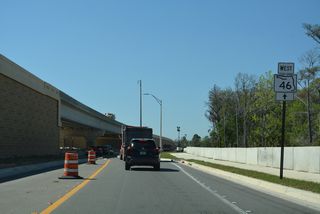
| Leading away from CR 15 (Upsala Road) south and U.S. 17/92 (Monroe Road) north on SR 46 westbound. 09/02/19 |
|
| Rinehart Road (unsigned CR 431B) intersects the six lane arterial along SR 46 north from retail areas east of Seminole Towne Center mall and an exchange with SR 417 (Seminole Expressway). 09/03/17 |
|
| A parclo interchange joins SR 46 with Interstate 4 west beyond the forthcoming signal with Towne Center Boulevard. 09/02/19, 09/03/17 |
|
| A fourth lane opens along SR 46 west for Interstate 4 eastbound to DeBary, Orange City, Deltona, DeLand and Daytona Beach. 09/02/19 |
|
| A loop ramp follows from SR 46 west to Interstate 4 westbound to Altamonte Springs, Maitland and Orlando. 03/02/22 |
|
| Oregon Street south and Wayside Drive east come together at a traffic light with SR 46 to the immediate west of Interstate 4. Oregon Street provides a through route north to Orange Boulevard (CR 431). Wayside Drive stems southwest to International Parkway. 03/02/22 |
|
| International Parkway takes a winding course southward from SR 46 at Terracina Drive to Lake Mary Boulevard. The arterial serves a crop of business parks and office complexes west of the Interstate 4 corridor through Heathrow. A new ramp with SR 417 opened from the parkway in 2012. 03/02/22 |
|
| Lake Forest Boulevard ties into SR 46 just west of International Parkway as the lone entrance road for the Lake Forest community. 03/02/22 |
|
| Orange Boulevard (unsigned CR 431) arcs three miles northeast around the Lake Forest community and other suburban development to U.S. 17/92 (Monroe Road) at Lake Monroe. Southward CR 431 extends 1.75 miles to H.E. Thomas, Jr. Parkway (CR 46A) east to Lake Mary. 03/02/22 |
|
| Confirming marker posted west of Orange Boulevard (CR 431). 03/02/22 |
|
| Opened to traffic southbound on August 15, 2022, a wye interchange connects SR 46 with SR 429 (Wekiva Parkway) at Orange Avenue. 03/02/22 |
|
| Construction for Wekiva Parkway Section 7A overlaid SR 46 west from Orange Avenue. SR 46 was realigned onto a frontage road system for SR 429. Glade View Drive is the first of five roundabouts added along SR 46 west to the Wekiva River. 03/02/22 |
|
| SR 46 and parallel SR 429 shift northward by Yankee Lake from Lake Markham Road. 03/02/22 |
|
| Lake Markham Road (unsigned CR 46A) travels south from SR 46 and Lower Wekiva River Preserve State Park to Markham Road at Markham Woods county park.
A roundabout was constructed with the Wekiva Parkway frontage road system here below the SR 429 mainline. 09/03/17 |
|
| A roundabout joins SR 46 with Lake Markham Road south to Sylvan Lake Park, Lake Markham and Markham Road (CR 46A). 03/02/22 |
|
| SR 46/429 continue west between Yankee Lake and the Bella Foresta subdivision. 03/02/22 |
|
| Yankee Lake Road stems north from the third roundabout along SR 46 westbound. 03/02/22 |
|
| Longwood Markham Road (unsigned CR 46A) concludes at SR 46 north the Foxspur and Markham Forest subdivisions. 03/02/22 |
|
| CR 46A lines Longwood Markham Road 1.5 miles south and Markham Road east 2.6 miles to Orange Boulevard (CR 431) en route to Lake Mary. 03/02/22 |
|
| The second entrance ramp to Wekiva Parkway from SR 46 westbound joins SR 429 south just beyond Longwood Markham Road (CR 46A). 03/02/22 |
|
| Osprey Hammock Trail ties into SR 46 from the Estates at Wekiva Park subdivision at another roundabout built along the SR 429 frontage road system. 03/02/22 |
|
| The roundabout with Osprey Hammock Trail also links with Wekiva Park Drive north into Lower Wekiva River Preserve State Park. 03/02/22 |
|
| The ensuing six miles of SR 46 west are a part of Florida Black Bear habitat. 03/02/22 |
|
| SR 46 was realigned to parallel the south side of SR 429 during Section 6 construction of Wekiva Parkway. Both routes span the Wekiva River west into Lake County. 03/02/22 |
|
| SR 46 shifts back to the north side of SR 429 at Wekiva River Road. 03/02/22 |
|
| Conservation areas in eastern Lake County, including Seminole State Forest, spread north of SR 46. 03/02/22 |
|
| SR 46 constitutes a frontage road running directly alongside SR 429 for 4.9 miles west from Wekiva River Drive. 03/02/22 |
|
| Wildlife Crossing #2 is a lengthy viaduct system taking Wekiva Parkway and SR 46 west by Rock Springs Run Reserve. 03/02/22 |
|
| Rock Springs Run State Reserve lies south of SR 46. The access road to the parkland is sometimes referenced as CR 433 on maps, though no signs are posted for the route in the field. 03/02/22 |
|
| Reassurance marker posted west of Sleepy Bear Lane, the access road to old SR 46 (Deerwood Farms Road) and Rock Springs Run State Reserve. 03/02/22 |
|
| SR 46 diverges from adjacent Wekiva Parkway to CR 46A just north of Exit 44. Wekiva Parkway Section 4A opened to traffic on January 20, 2016 southwest 2.8 miles from SR 46 to CR 435 (Mt. Plymouth Road) at a temporary at-grade connection. 03/02/22 |
|
| Section 5 construction for Wekiva Parkway realigned CR 46A southward from an alignment east through Seminole State Forest, to SR 429 at Exit 44. 03/02/22 |
|
| The eastern section of SR 46 concludes at CR 46A. CR 46A runs 3.6 miles north from SR 429 to Seminole Springs and SR 44 east of Eustis. 02/12/21 |
|
| Old SR 46 branches west from CR 46A in 0.6 miles along Sorrento Avenue (CR 46) into Mount Plymouth. 03/02/22 |
|
| Entering the community of Mt. Plymouth along Sorrento Avenue (CR 46) west. Mt. Plymouth consists of a network of streets built around the Mount Plymouth Golf Club, a 140 acre course that closed in 2007.1 02/27/16 |
|
| SR 46 was decommissioned between CR 46A and the Mt. Dora Connector (SR 453) and renamed Sorrento Avenue. Passing through Mt. Plymouth, Sorrento Avenue intersects CR 435 (Niles Street) south. 02/27/16 |
|
| Lake County Road 435 follows Niles Street, Westchester Avenue, Tulare Street, and Glencoe Avenue as it meanders southward to the Orange County line. 02/27/16 |
|
| CR 435 (Niles Street) travels 1.67 miles from Mt. Plymouth to northern annexations of Apopka in Orange County. Following Mt. Plymouth Road, CR 435 heads 2.7 miles from the county line to Rock Springs Road and Kelly Park; Rock Springs Road continues the drive southward toward Downtown Apopka. 02/27/16 |
|
| Another seven miles separate Mt. Plymouth from Mt. Dora along Sorrento Avenue (CR 46) westbound. 02/27/16 |
|
| Lake County Road 437 ties into CR 46 (Sorrento Avenue) from East Lake Community Park. 02/27/16 |
|
| CR 437 runs 4.75 miles north to CR 44A, meeting SR 44 midway. An implied overlap with CR 46 (Sorrento Avenue) west takes CR 437 south to Averil Street. 02/27/16 |
|
| CR 46 (Sorrento Avenue) enters unincorporated Sorrento on the half mile leg between County Road 437 north and south. 03/02/22 |
|
| Lake County Road 437 resumes a southward heading from CR 46 (Sorrento Avenue) to Orange County. CR 437 follows Plymouth-Sorrento Road from the county line to Apopka and U.S. 441 (Orange Blossom Trail). 03/02/22 |
|
| County Road 437 (Averil Street) travels 1.498 miles south from Sorrento to the Orange County line, where it passes under the systems interchange connecting SR 429 (Wekiva Parkway) with SR 453 (Mt. Dora Connector). 02/12/21, 03/02/22 |
|
| SR 46 advances west through the Sorrento street grid before shifting southward alongside an abandoned Seaboard Coast Line railroad. 03/02/22 |
|
| Shifting southward parallel to a Florida Central Railroad line, CR 46 (Sorrento Avenue) meets the Mt. Dora Connector (SR 453) west of Sorrento. SR 453 leads south to SR 429 at northwest Apopka. 03/02/22 |
|
| The Mt. Dora Connector (SR 453) branches 3.4 miles northwest from SR 429 (Wekiva Parkway) to link with Sorrento Avenue at a partial trumpet interchange. 03/02/22 |
|
| Both the Mt. Dora Connector and Wekiva Parkway utilize all electronic toll (AET) collection. Toll gantries collect fares between respective interchanges along both expressways. 03/02/22 |
|
| Round Lake Road intersects SR 46 just west of the Mt. Dora Connector and ahead of the Mt. Dora city limits. The state road advances west through rural areas to the Summerbrooke community. 03/02/22 |
|
| Wekiva Parkway Section 3A construction widened SR 46 west 1.4 miles from Round Lake Road to a point east of Vista View lane. Work started on October 30, 2017 and was finished in Spring 2020. 03/02/22 |
|
| SR 46 west at Vista View. Section 3B construction Wekiva Parkway expanded the SR 46 into a six lane arterial west to U.S. 441. 03/02/22 |
|
| SR 46 curves southwest from Sabastian Street and the Summerbrooke neighborhood to conclude at U.S. 441. 03/02/22 |
|
| U.S. 441 enters Mt. Dora from Tangerine and Zellwood in unincorporated Orange County. Following Orange Blossom Trail, U.S. 441 travels southeast to Apopka and Orlando. 03/02/22 |
|
| U.S. 441 circumvents the city of Mount Dora along an arterial bypass west to Eustis, Taveras and Leesburg. 03/02/22 |
|
| Section 3B construction through Spring 2020 replaced the diamond interchange joining SR 46 and U.S. 441 with an at-grade intersection and a new flyover from U.S. 441 south to SR 46 east. The previous exchange dated back to 1961. 03/02/22 |
|
| Lake County Road 46 extends west 0.603 miles along 1st Avenue into the Mount Dora residential street grid. 03/02/22 |
|
| CR 46 (E 1st Avenue) concludes at Old CR 441 (S Highland Street) southeast of Downtown Mt. Dora. 03/02/22 |
|
| Old CR 441 (S Highland Avenue) south becomes Orange County Road 500A, 0.97 miles from U.S. 441 (Orange Blossom Trail) at Tangerine. 03/02/22 |
|
| 1st Avenue (CR 46) west at Highland Street. Old CR 441 north navigates along 5th Avenue west through Downtown Mt. Dora, emerging along the north shore of Lake Dora toward Tavares. 03/02/22 |
Page Updated 11-09-2022.


 West
West Sorrento Avenue - West
 West
West West
West


