
Pinellas County was formed in 1912, when it separated from Hillsborough County. A popular beach destination, magazines routinely rate Pinellas County beaches among the best in the entire country. However, with only 280 square miles and a booming population of 916,542 as of the 2010 Census, Pinellas County is perhaps the most densely populated county in Florida. Even Miami-Dade County, with its dense urban atmosphere near the coast has a significant amount of undeveloped land in the Everglades. No similar amount of undeveloped land is found in Pinellas County, with the exception of the Brooker Creek Preserve north of Oldsmar.
Interstate Highways
U.S. Highways
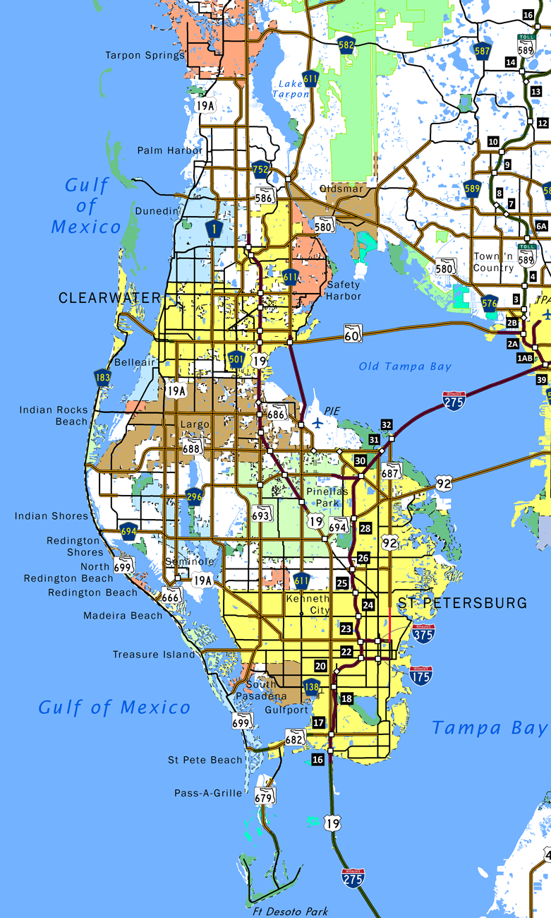
Unconstructed Pinellas Belt Expressway
There are several freeways that were planned but were canceled and not constructed. One of these was the Pinellas Belt Expressway, which was touted as a beltway that would connect with the Interstate 275 and Interstate 175 interchange at its southeastern end. It was then planned to follow today’s U.S. 19 Alternate/SR 595 west to Seminole Boulevard and then aim north, connecting with the unconstructed Ulmerton Road Freeway (SR 688, which is no longer slated to be upgraded to a freeway) and then merging with the canceled St. Petersburg-Clearwater Expressway, a diagonal route from Interstate 275 north of the I-275/375 interchange and angling northwest to Largo near the U.S. 19 Alternate and SR 686 (East Bay Drive) intersection.
The Pinellas Belt Expressway was actually budgeted for construction in 1974, but local opposition prevented the freeway from progressing. This freeway would have taken via eminent domain a good deal of commercial areas, including retail outlets, but several homes would also have to be condemned and removed. This was unacceptable to residents, so the freeway was canceled by the late 1970s. However, certain segments were built, including the full freeway interchange between U.S. 19 Alternate and SR 666 in Bay Pines/Seminole.
State Roads

Guides:
Drew St / NE Coachman Rd / 10th St S / Philippe Parkway
Split into two segments, with a portion relinquished from state control through Safety Harbor, State Road 590 is an L-shaped route in northern Pinellas County. The state road lines Drew Street, an urban boulevard east from U.S. 19 Alternate outside Downtown Clearview to NE Coachman Road. Angling northeast, Coachman Road connects with U.S. 19 at 10th Avenue S, which extends SR 590 east to Dellwood and CR 611 (McMullen Booth Road). Through the city of Safety Harbor, SR 590 takes a stair stepped route along 10th Avenue S, 14th Avenue S, 4th Avenue S and 10th Avenue S again to Main Street (CR 576). State maintenance ends at 10th Avenue S and Main Street continues east through Downtown Safety Harbor to Phillippe Parkway. SR 590 turned north there and follows Phillippe Parkway as it parallels the west shore of Safety Harbor. North from Wateredge Court, the northern segment of SR 590 overlays Phillippe Parkway to SR 580 at Bridgeport.

Guides:
5th Avenue North
State Road 595 is a 37.31 mile long route that accompanies U.S. 19 Alternate throughout Pinellas County. The route is posted along side the U.S. 19 Alternate (5th Avenue N) spur east from U.S. 19 (34th Street S) to the west end of U.S. 92 and SR 687 along 4th Street S in St. Petersburg. The remainder of SR 595 is unsigned along U.S. 19 Alternate north from Bay Pines through Seminole, Largo, Clearwater, Dunedin, Palm Harbor and Tarpon Springs. SR 595 and U.S. 19 Alternate conclude just across the Pasco County line at Holiday.

Guides:
Tom Stuart Causeway
SR 666 is a 1.39 mile long connector that follows 150th Avenue and Tom Stuart Causeway between SR 699 (Gulf Boulevard) in Madeira Beach and the three-wye interchange with U.S. 19 Alternate / SR 595 (Bay Pines Boulevard / Seminole Boulevard) in Seminole.
The interchange between SR 666 and U.S. 19 Alternate is a remnant of a freeway that was once proposed for the SR 595 and U.S. 19 Alternate corridor between Interstate 275 and Largo via Seminole. Known as the Pinellas Belt Expressway, this freeway was proposed in 1974 for construction by 1979, but it was removed from plans as a result of community opposition.

Guides:
Pinellas Bayway
SR 682 is a 3.72 mile route that follows the Pinellas Bayway from SR 699 (Gulf Boulevard) in St. Pete Beach east to Interstate 275 and U.S. 19 (34th Street S) near Eckerd College in St. Petersburg. Tolls are collected along the Bayway eastbound over the Intracoastal Waterway and westbound over Boca Ciega Bay Channel. The eastern portion of SR 682 follows 54th Avenue S.

Guides:
East Bay Drive / Roosevelt Boulevard
State Road 686 is a 10.82 mile route that begins at the intersection of U.S. 19 Alternate (Seminole Boulevard / Missouri Avenue) and West Bay Drive in the city of Largo. Eastward, SR 686 travels along East Bay Drive, changing into Roosevelt Boulevard at the diamond interchange with U.S. 19. 1.25 miles from there, Roosevelt Boulevard angles southeast to St. Petersburg-Clearwater International Airport (PIE), where the tolled Gateway Expressway (SR 686A) is being built alongside SR 686.
SR 686 turns east from below the Gateway Expessway (SR 686A) at a SPUI joining the toll road with SR 688 (Ulmerton Road). SR 686/688 overlap 1.03 miles east along Ulmerton Road to a wye interchange with the southern leg of Roosevelt Boulevard by Feather Sound. SR 688 extends 1.51 miles east along Ulmerton Road to Interstate 275 north while SR 686 (Roosevelt Boulevard) advances southeast to Carillon, Interstate 275 south and SR 694 (Gandy Boulevard) in north St. Petersburg.
A portion of SR 686 that is concurrent with SR 688 near the airport was considered in the early 1970s for the Ulmerton Expressway, which would have followed all of SR 688 from Largo east to Interstate 275. That freeway was canceled by the mid-1970s. Prior to 2017, the eastern end of the state road tied into a congested intersection with U.S. 92 and SR 687 (4th Street N) at both the ends of SR 694 (Gandy Boulevard) and unsigned SR 600, the companion of U.S. 92 (Gandy Boulevard) east to the Gandy Bridge. A split diamond interchange was constructed here during the $83 million project that upgraded 2.5 miles of SR 694 to freeway standards.

Guides:
4th Street North
State Road 687 runs parallel to Interstate 275 from Downtown St. Petersburg north to the Howard Frankland Bridge approach at Big Island. The state road runs almost entirely along 4th Street, with the exception of the one way couplet through Downtown where northbound utilizes 3rd Street and one block of 5th Avenue N. SR 687 doubles as U.S. 92 between 5th Avenue N (U.S. 19 Alternate / SR 595) and Gandy Boulevard (SR 600 / 694). This overlap is fully signed.
Historically SR 687 continued south from Interstate 175 and SR 594 (5th Avenue S) through south St. Petersburg to Pinellas Point. This alignment utilized 4th Street S to Big Bayou and 6th Street S from there to 45th Avenue S and 4th Street S again to Pinellas Point Drive. Some maps show an east to west branch of SR 687 routed along Pinellas Point Drive, Royhanna Drive and 62nd Avenue S between U.S. 19 and 4th Street S.

Guides:
Ulmerton Road
SR 688 comprises a 13.33 mile long state road between Indian Rocks Beach at the north end of SR 699 (Gulf Boulevard) and Interstate 275 at Exit 31B in north St. Petersburg. SR 688 follows 5th Avenue through Indian Rocks Beach, crosses the Intracoastal Waterway, then enters the vicinity of Largo via Walsingham Road. A direct connection from Walsingham Road to Ulmerton Road curves SR 688 northeast around Ridgecrest County Park to a due east heading to Largo Mall, northern reaches of Pinellas Park and St. Pete-Clearwater International Airport (PIE).
SR 688 (Ulmerton Road) combines with SR 686 east from the SPUI with the Gateway Expressway (SR 686A) near PIE Airport 1.03 miles to Roosevelt Boulevard south at Carillon. An upgrade of SR 686 along Ulmerton Road was previously considered in the early 1970s for the proposed Ulmerton Expressway. Cancelled due to local opposition by the mid 1970s, the freeway that would have connected Largo with Interstate 275.


Gateway Expressway
The Gateway Expressway is a toll road system with separate branches linking Interstate 275 with U.S. 19 and St. Petersburg-Clearwater International Airport (PIE). SR 690 will overlay CR 296 (118th Avenue N / Bryan Dairy Road) along a four lane elevated roadway west from I-275 to U.S. 19. SR 686A will comprise a four lane viaduct system running along SR 686 (Roosevelt Boulevard) southeast from the Bayside Bridge (CR 611) to SR 690 just west of I-275. Both expressways will use all electronic tolling (AET).
Costing $594.7 million, construction on the Gateway Express project commenced in November 2017. Associated work reconstructs Roosevelt Boulevard from the Bayside Bridge to SR 688 (Ulmerton Road), adds a new access road for PIE Airport, and expands I-275 between SR 694 (Gandy Boulevard) and SR 687 (4th Street N) with express toll lanes. Work runs through <del>late 2021</del> early 2023.

Guides:
Corey Causeway / 66th Street North
SR 693 begins in the business district of St. Pete Beach at the turn of SR 699 from 75th Street to Blind Pass Road. The state road provides the first toll free crossing (Corey Causeway) of the Intracoastal Waterway north of the Pinellas Bayway as it leads northeast to South Pasadena and St. Petersburg. Skirting the west side of Pinellas Park, SR 693 lines 66th Street N until it converges with U.S. 19 (SR 55) in eastern reaches of Largo. The state road is 11.96 miles long.


Guides:
Park Boulevard / Gandy Boulevard
Collectively Park Boulevard to the west and Gandy Boulevard to the east, the combination of County and State Road 694 travels across Pinellas County between Indian Shores and St. Petersburg. The county road portion originates at SR 699 (Gulf Boulevard) along the Park Boulevard Bridge (78th Avenue Bridge) spanning the Intracoastal Waterway east to Oakhurst. The arterial route proceeds across the city of Seminole into Pinellas Park, where it becomes State Road 694 at 66th Street N (SR 693).
SR 694 extends 6.04 miles east initially as a commercial boulevard to The Shoppes at Park Place Mall and a SPUI with U.S. 19 and northeast as a controlled access expressway from Grand Avenue to the five-way intersection with 4th Street N (U.S. 92 and SR 687) and Roosevelt Boulevard (SR 686) in St. Petersburg.
The Gandy Freeway was proposed as a 12.6 mile long freeway that would have connected directly to the Gandy Bridge (and to the Leroy Selmon Crosstown Expressway in Hillsborough County). It was first considered in the 1960s but was canceled by 1979. A subsequent project started in 2014 upgraded Gandy Boulevard from I-275 east to 4th Street N to a limited access highway, with bridges over Dr. Martin Luther King Street (CR 803), SR 686 (Roosevelt Boulevard) and SR 687. Construction wrapped up in Spring 2018.

Guides:
Gulf Boulevard
Following the Gulf of Mexico barrier islands in southwest Pinellas County, State Road 699 travels 16.49 miles north from St. Pete Beach to Indian Rocks Beach. The route is more popularly known as Gulf Boulevard, which it follows for its entirely except between 75th Avenue and Blind Pass on Sand Key.
SR 699 used to continue further south and north from its current end points. The southern extension took it along Pass-a-Grill Way between Pinellas Bayway and Pass-a-Grille Point. North from Indian Rocks Beach, SR 699 continued along Gulf Boulevard through to the then tolled Clearwater Pass Bridge linking Long Key with Clearwater Beach Island. Additionally an eastern branch was signed along Madeira Beach Causeway. This is now SR 666. Some historical maps, including the USGS Quadrangle map, also show Corey Causeway (SR 693) as another branch of SR 699.
County Roads
Pinellas County Roads are generally only signed in unincorporated areas. This leaves some routes with few markers and others completely unsigned.
![]() Treasure Island Cswy / Central Ave
Treasure Island Cswy / Central Ave
![]() Oakhurst Rd / Indian Rocks Rd
Oakhurst Rd / Indian Rocks Rd
![]() Belleair Road
Belleair Road
![]() Belcher Road
Belcher Road

Guides:
Park Street / Starkey Road / Keene Road
Pinellas County Road 1 follows Park Street from Central Avenue in South Pasadena north to Pinellas County Road 694 (Park Boulevard). Starkey Road extends the route north from Park Boulevard to SR 686 (East Bay Drive). Keene Road represents the northern leg of the county road between East Bay Drive and SR 60 (Gulf-to-Bay Boulevard). A separate County Road 1 is signed in western Pasco County.

Guides:
Gulfport Boulevard / 22nd Avenue South
CR 138 connects SR 693 (Pasadena Avenue S) with U.S. 19 (34th Street S) along Gulfport Boulevard and 22nd Avenue S in southern Pinellas County. The 3.86 mile long arterial route links the city of South Pasadena, unincorporated Bear Creek, the city of Gulfport and south St. Petersburg at the Childs Park neighborhood.

Guides:
38th Avenue North
A major urban boulevard, 38th Avenue N doubles as Pinellas County Road 184 between U.S. 19 Alternate (Tyrone Boulevard) and U.S. 92 (4th Street N) across the city of St. Petersburg. The county road designation is one of the better marked routes within Pinellas.

Guides:
54th Avenue North
54th Avenue N comprises a main arterial from CR 1 (Park Street) to U.S. 92/SR 687 (4th Street N) through Kenneth City, Lealman and a portion of St. Petersburg. The four lane roadway is also CR 202, though signs are only posted in unincorporated Pinellas County.

Guides:
62nd Avenue North
62nd Avenue N is a minor urban arterial stretching 5.00 miles east from Belcher Road outside Pinellas Park to 16th Street N in St. Petersburg, and a major collector from 16th Street N 2.81 miles east to Bayou Grande Boulevard NE off Bayou Grande. 62nd Avenue N is also County Road 216 between SR 693 (66th Street N) in Pinellas Park and U.S. 92/SR 687 (4th Street N) in St. Pete.

Guides:
Bryan Dairy Road / 118th Avenue North
Pinellas County Road 296 is fairly well signed along Bryan Dairy Road and 118th Avenue N within the Pinellas Park and St. Petersburg area. The route begins along a freeway spur leading west from Interstate 275 to 31st Court N at 118th Avenue N. Construction started on August 21, 2017 builds elevated lanes for the tolled Gateway Expressway (SR 690) along the CR 296 right of way west from I-275 to U.S. 19.

Guides:
Belcher Road
Pinellas County Road 501 follows Belcher Road from Park Boulevard (CR 694) north to CR 816 in Palm Harbor. The Belcher Expressway was proposed in 1965 along 10.6 miles of Belcher Road through Pinellas Park and Largo as an alternative to U.S. 19. Plans for the freeway were canceled in 1978.

Guides:
49th St, Bayside Bridge, McMullen Booth Rd, East Lake Rd
County Road 611 travels nearly the height of Pinellas County, originating in Gulfport and extending north to the Pasco County line near Tarpon Springs. Through St. Petersburg, Lealman and Pinellas Park, CR 611 follows 49th Street North, a varying four lane boulevard or six lane arterial. Crossing western reaches of Old Tampa Bay, CR 611 upgrades to an expressway over the Bayside Bridge to SR 60 (Gulf to Bay Boulevard) at Clearwater.
McMullen Booth Road continues CR 611 north with four to six lanes along the Safety Harbor city to northeast Clearwater. Spanning Lake Tarpon Canal, CR 611 shifts onto East Lake Road through northern Pinellas County. Passing east of Lake Tarpon, CR 611 becomes CR 77 (Seven Springs Boulevard) across the Pasco County line en route to New Port Richey.

Guides:
22nd Avenue North
22nd Avenue N is a four lane arterial varying as a canal lined route, commercial boulevard and tree lined street across St. Petersburg. 22nd Avenue N starts as a local street from Park Street off Boca Ciega Bay. Heading east, 22nd Avenue N expands to four lanes from Tyrone Square Mall and U.S. 19 Alternate (Tyrone Boulevard) east through the Holiday Park area to U.S. 92 (4th Street N) at Historic Old Northeast. A portion of the route is inventoried as unsigned County Road 690.

Guides:
9th Avenue North / Haines Road
Pinellas County Road 691 lines Haines Road northwest from 23rd Street N and 50th Avenue N at Grovement in St. Petersburg to U.S. 19/34th Street N in Pinellas Park. The route is marked within unincorporated Lealman.
Haines Road was previously designated as part of CR 689. CR 689 also followed 9th Street N from SR 595 (5th Avenue) to 34th Avenue N, where it transitioned onto Haines Road northwest to U.S. 19.
Updated December 15, 2021.