| U.S. 395 south |
|
This mileage sign along U.S. 395 south provides the distance to California 270 (Bodie Road) (six miles), California 167 east to Hawthorne (18 miles), and Los Angeles (358 miles). Photo taken 07/09/07. |
|
As U.S. 395 again turns south, we see more gorgeous mountain scenery rising above the valley. Photo taken 07/19/09. |
|
The next left connects to Jack Sawyer Road. Photo taken 07/25/09. |
|
A ranger station for the national forest is located ahead; for wilderness permits and assistance related to the forest areas, turn left ahead. Photo taken 07/09/07. |
|
|
|
|
Another series of great views of the Sierra Nevada are found along U.S. 395 south. The highway continues with two lanes, with the next major intersection located at California 270. Thunderstorms often form over the Eastern Sierra during the heat of Summer. Photos taken 07/09/07, 07/19/09, 07/25/09, and 09/07/09. |
|
|
|
|
|
|
|
|
|
U.S. 395 passes through Willow Springs, which has a motel and limited other facilities and services. Photo taken 07/25/09. |
|
Soon thereafter, southbound U.S. 395 approaches California 270/Bodie Road at the upcoming intersection. A left turn connects to this road, which only travels to Bodie State Historic Park. Photo taken 07/25/09. |
|
California 270 travels east from U.S. 395 to the entrance to Bodie State Historic Park. Bodie is an old mining town that is preserved as part of the state park. Visitors can walk through the town and attend tours. However, no motorist services are in the park, and the last several miles of highway into the park (technically not part of California 270 but the logical continuation of the route to the park entrance) are dirt/graded road, unpaved. Photo taken 09/07/09. |
|
After the California 270 intersection, this mileage sign along U.S. 395 south provides the distance to California 167 (12 miles), Lee Vining (California 120, 20 miles), and Los Angeles (352 miles). Photo taken 09/07/09. |
|
|
The Sierra Nevada continue to rise to the west of U.S. 395. Photos taken 09/07/09 and 07/15/09. |
|
|
|
|
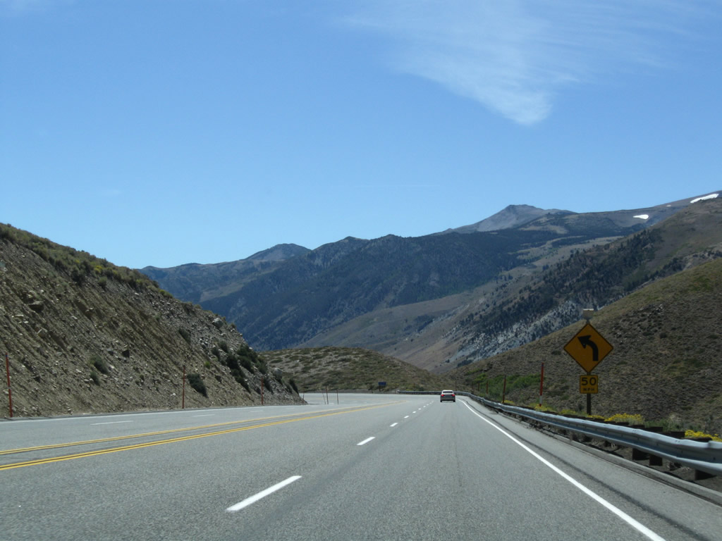
U.S. 395 continues to gain elevation as the passing lane continues and the highway approaches a curve in the roadway ahead. Photos taken 07/09/07, 09/07/09, and 07/19/09. |
|
An old alignment of U.S. 395 is no longer in use can be seen abandoned on the side of the highway. Photo taken 09/07/09. |
|
The four-lane highways curves toward the west as we approach Conway Summit and Virginia Lakes Road. Photo taken 09/07/09. |
|
Southbound U.S. 395 (Three Flags Highway) approaches Virginia Lakes Road, which connects to to Trumbull Lake and Virginia Lakes. Photo taken 09/07/09. |
|
|
U.S. 395 reaches Conway Summit (el. 8,138 feet) and begins the six percent descent to Mono Lake. Conway Summit is the highest point on U.S. 395 between Interstate 15 in Hesperia and the U.S.-Canada International Border, where the route changes into British Columbia 395. Photos taken 07/19/09 and 07/09/07. |
|
|
|
|
U.S. 395 descends from Conway Summit down to Mono Lake. While retaining four lanes for the entire descent, U.S. 395 sees a series of sweeping switchbacks to carry the busy highway downhill at a grade that does not exceed six percent. At the second curve, Mono Lake comes into view. An overlook is available for southbound travelers to stop and look down on the scenic lake. Photos taken 07/09/07, 07/19/09, 07/25/09, and 09/07/09. |
|
|
|
|
|
|
|
|
|
|
|
|
A small kiosk and Blue Star Highway marker are posted at the scenic overlook toward Mono Lake. The kiosk provides tourist information for nearby attractions (such as Mono Lake, Bodie, Tioga Pass/Yosemite, Lee Vining Canyon, and Lundy Lake). A second panel provides the history of Mono Lake and the impact of Los Angeles Department of Water and Power taking water from inbound streams; this practice ended in 1994 with a state water board action. Photos taken 07/09/07. |
|
|
|
|
|
|
|
|
Continuing downhill, this series of photos follows the remainder of U.S. 395 down from Conway Summit. Near the bottom of the hill is the left turn to Conway Ranch Road and a right turn to Mill Creek Power House Road. The four-lane segment then ends and changes into two lanes; the highway will remain two lanes until it enters Lee Vining on the southwest side of Mono Lake. Photos taken 07/09/07, 07/19/09, 07/25/09, and 09/07/09. |
|
|
|
|
|
|
|
|
|
|
|
|
|
|
Now at the bottom of the Conway Grade, southbound U.S. 395 approaches California 167, which travels east to Hawthorne, Nevada. Initially California 167 travels mostly east on an arrow-straight path toward the state line with Nevada. At the state line, California 167 changes into Nevada 359. From there, Nevada 359 travels over Anchorite Summit (el. 7,626 feet) in the Humboldt-Toiyabe National Forest and then turns north for the final distance to Hawthorne, which is 55 miles from here. Turn right at this intersection with Lundy Lake Road west to Lundy Lake campground. Photos taken 07/09/07. |
|
|
|
A U.S. 395 south reassurance shield is posted shortly after the California 167 intersection. Photo taken 07/09/07. |
|
|
This mileage sign along southbound U.S. 395 provides the distance to Lee Vining (seven miles), California 158 (June Lake Loop) (18 miles), and San Diego (427 miles). This is the first southbound mileage sign to show the control city as San Diego along U.S. 395. San Diego is the former southern terminus of U.S. 395. With the completion of Interstate 15 and Interstate 215, the southern terminus of U.S. 395 was retracted to Hesperia. Photos taken 07/09/07 by AARoads and 04/25/04 by Trevor Carrier. |
|
|
|
U.S. 395 proceeds south along the west shore of Mono Lake (el. 6,402 feet and rising). A saline lake, the waters of Mono Lake are not suitable for drinking. However, Los Angeles Department of Water and Power diverted the waters of Rush Creek from Mono Lake in 1941 to its long-running aqueduct leading south to Owens Valley and from there to Los Angeles. Due to the environmental damage to the lake and resultant lowering of the lake level, this diversion ended in 1994 by order of the California State Water Resources Control Board. The elevation of the lake has continued to rise since diversions stopped. The largest islands in Mono Lake are Negit Island and Paoha Island. A visitors center is located south of here close to Lee Vining on the east side of U.S. 395. Photos taken 07/09/07, 07/19/09, 07/25/09, and 09/07/09. |
|
|
|
|
|
|
|
|
|
|
A turnoff from U.S. 395 connects to Mono Lake access points. The first left (seen in previous series of photos) connects to Mono Lake County Park. Motorists can also turn at the second left to an access point. Photos taken 07/09/07, 07/19/09, 07/25/09, and 09/07/09. |
|
|
|
|
|
U.S. 395 continues with four lanes after the second Mono Lake access turnoff. The highway ascends this rise prior to the Mono Lake Visitors Center, followed by Lee Vining. Photo taken 09/07/09. |
|
Southbound U.S. 395 approaches the turnoff to the Mono Basin National Forest Visitors Center. Visitor and tourist information is available here, along with great views of the lake. Ahead, U.S. 395 enters Lee Vining. Photo taken 09/07/09. |
|
U.S. 395 enters the unincorporated community of Lee Vining (el. 6,781 feet), with two lanes in each direction and a center turning lane. Motorist services -- including gas, food, and lodging -- line both sides of U.S. 395. With its proximity to Yosemite National Park, Bodie State Historic Park, and Mono Lake, Lee Vining has established itself as a tourist destination. Photo taken 09/07/09. |
|
The Lee Vining Chamber is located near the center of town; look for it on the right side of the highway. Photo taken 07/09/07. |
|
A retaining wall allows for U.S. 395 to continue with five lanes out of Lee Vining and onward to the intersection with California 120. Photo taken 07/09/07. |
|
Southbound U.S. 395 approaches California 120 just south of Lee Vining. California 120 travels west over Tioga Pass into Yosemite National Park. A fee is assessed on all vehicles traveling over Tioga Pass as part of entry into the national park. Additionally, this route over Tioga Pass is closed in winter. Tioga Pass is one of the highest mountain passes with a paved road passing over it (el. 9,945 feet). Once west of Yosemite, California 120 joins California 108 en route to Oakdale, then splits toward Manteca, becoming a freeway for the final distance to Interstate 5 and Interstate 205 in Lathrop. Photo taken 07/09/07. |
|
Southbound U.S. 395 meets California 120 and Airport Road at this intersection. Turn left to Lee Vining Airport or right to follow California 120 to Tioga Pass and Yosemite National Park. U.S. 395 south and California 120 east share pavement for the next several miles before splitting near the June Lake Loop intersection. Photo taken 07/09/07. |
| U.S. 395 (Three Flags Highway) south and California 120 east |
|
This mileage sign along U.S. 395 south and California 120 east provides the distance to California 158 (June Lake Loop) north intersection (four miles), California 120 east to Benton (five miles), and Los Angeles (332 miles). Photo taken 07/09/07. |
|
U.S. 395 south and California 120 east widen to four lanes with a median barrier. This configuration becomes more prevalent southward. Photo taken 07/19/09. |
|
Southbound U.S. 395 and eastbound California 120 approach Test Station Road (next left). Photo taken 09/07/09. |
|
The next signed intersection along U.S. 395 south and California 120 east is with Oil Plant Road. Photo taken 09/07/09. |
|
As usual, the mountain scenery alongside U.S. 395 is unbelievably beautiful. Photo taken 07/25/09. |
|
Southbound U.S. 395 and eastbound California 120 approach California 158 (June Lake Loop) (one-half mile). As a loop, California 158 begins at this intersection, turns west and then south toward June Lake, then turns back east to rejoin U.S. 395 north of Mammoth Lakes. This intersection is called the June Lake Loop North intersection by Caltrans; the cardinal direction of California 158 would be north-south. Photo taken 09/07/09. |
|
The June Lake Loop is a popular spot for fishing, camping, hiking, and other outdoor recreational opportunities. Photo taken 07/25/09. |
|
As a set of power lines cross over the four-lane expressway, southbound U.S. 395 and eastbound California 120 meet California 158 (June Lake Loop) at this intersection. Photo taken 07/09/07. |
|
Immediately after the California 158 (June Lake Loop) north intersection, southbound U.S. 395 and eastbound California 120 prepare to split. California 120 travels east from here to Benton via Sagehen Summit. California 120 is part of a major east-west corridor between Manteca (in the Central Valley) and Benton (U.S. 6) via Yosemite National Park and Tioga Pass (weather permitting). Photo taken 07/09/07. |
|
|
Southbound U.S. 395 splits with California 120 east. A mileage sign provides the distance to Benton (46 miles) and the South Tufa Formation on Mono Lake (five miles). An earlier photo (from 2001) shows the prior signage found here. Note the lack of a California 120 shield on this sign assembly. The 2001 photos showed distance in miles and kilometers; many of these signs were placed in the 1970s and have since been replaced with signs that do not include kilometers. Photos taken 07/09/07 by AARoads and 03/29/01 by Joel Windmiller. |
| U.S. 395 south |
|
A U.S. 395 south reassurance shield is posted shortly after the California 120 east intersection. Photo taken 07/09/07. |
|
This mileage sign along U.S. 395 south provides the distance to California 158 (June Lake Loop) (south junction) (six miles), California 203 west to Mammoth Lakes (20 miles), and Los Angeles (326 miles). Photo taken 07/19/09. |
|
Southbound U.S. 395 approaches West Portal Road and enters Inyo National Forest. Photo taken 07/19/09. |
|
Another U.S. 395 south reassurance shield is posted shortly after the intersection with West Portal Road. Photo taken 07/09/07. |
|
|
|
This series of photos follows U.S. 395 south through the Inyo National Forest as we gradually gain elevation and approach the California 158 June Lake intersection. Photos taken 07/09/07. |
|
|
|
|
|
|
|
Southbound U.S. 395 approaches the second (southern) junction with California 158 (June Lake Loop). Turn right ahead for the community of June Lake. Photo taken 07/19/09. |
|
The divided highway segment ends, and U.S. 395 again has an undivided, four-lane segment. Photo taken 07/09/07. |
|
Soon thereafter, southbound U.S. 395 meets California 158 west to June Lake, Gull Lake, and Silver Lake. Various campgrounds, resorts, and trailheads are located along the path of the loop, which will reunite with U.S. 395 northeast of Grant Lake. All motorist services are located in the community of June Lake, which is located on the south shore of June Lake. Photo taken 07/09/07. |
|
The "wide spot in the road" here is the right turn to California 158 (June Lake Loop) west to June Lake. The detour along the loop is well worth the time, even if just for viewing the mountain scenery. Photo taken 07/09/07. |
Page Updated April 19, 2010.