| Interstate 580/John T. Knox Freeway east |
|
The next exit along Interstate 580 east is Exit 13, Buchanan Street to Albany (left exit). This section of Interstate 580 was the last part constructed, and it was completed around 1993. Prior to that, Interstate 580 followed what used to be California 17. Photo taken 07/02/13. |
|
Eastbound Interstate 580 reaches Exit 13, Buchanan Street. Buchanan Street is the last exit from Interstate 580 east before it merges onto westbound Interstate 80. Together, Interstate 580 east and Interstate 80 west follow the southbound Eastshore Freeway en route to Berkeley and Oakland. For photos on the cosigned section, see the Interstate 80 page. Photo taken 07/02/13. |
|
The left lane departs to Exit 13, Buchanan Street, while the right two lanes connect to Interstate 80 (Eastshore Freeway) west. Photo taken 07/02/13. |
|
Eastbound Interstate 580 merges onto westbound Interstate 80 from the right. Watch for heavy traffic on the shared alignment of these two Interstate routes as they approach the San Francisco-Oakland Bay Bridge and downtown Oakland. Photo taken 07/02/13. |
| Interstate 580 east, Interstate 80 west, and Eastshore Freeway south |
| For pictures of the shared alignment between Interstate 580 and Interstate 80, please see the westbound Interstate 80 in Alameda and San Francisco Counties page. |
| Interstate 580/MacArthur Freeway east |
|
This view is found on the transition ramp from Interstate 80 east to Interstate 580 east. Ahead, the transition ramp will merge with mainline Interstate 580 east. The transition ramp carries three lanes of traffic as it separates from eastbound Interstate 80 and connects to Interstate 580. The next exit (Exit 19A) is a left exit leading into downtown Oakland. From here, Interstate 580 generally follows the route of U.S. 50 southeast to Hayward, then turns east toward the Altamont Pass. Prior to the extension of Interstate 580 to Marin County in the 1980s, this was the original mainline section of eastbound Interstate 580; now it is merely a transition ramp. Photo taken 04/06/09. |
|
Still in the Maze and after merging with the mainline and transition from the Bay Bridge, Interstate 580 has a variety of options: Exit 19A immediately exits left to serve MacArthur Boulevard (old U.S. 50) and San Pablo Avenue (old U.S. 40); Exit 19B, east California 24; and Exit 19C, west Interstate 980 (to Oakland International Airport). It is next to impossible to get from the Interstate 80 transition ramp to the left off-ramp for Exit 19A due to the sheer number of lanes. Photo taken 04/06/09. |
|
Interstates 80, 580, and 880 are part of a safety corridor. Photo taken 04/06/09. |
|
This sign advises motorists along eastbound to use Interstate 980 west to reach southbound Interstate 880. It was placed as part of the detours associated with the Loma Prieta Earthquake of 1989, but it is still in place even today, after the new highway was constructed. Photo taken 04/06/09. |
|
Eastbound Interstate 580 approaches Exit 19B, California 24 east to Berkeley, Orinda, Lafayette, and Walnut Creek. Photo taken 04/06/09. |
|
Trucks are restricted on Interstate 580 east of California 24. Use Interstate 980 west to Interstate 880 south as an alternative. Photo taken 04/06/09. |
|
|
Eastbound Interstate 580 reaches Exit 19B, California 24/William Byron Rumford Freeway east. The next exit is Exit 19C, Interstate 980/Grove Shafter Freeway west. Note the green overlay panel on the Interstate 980 sign; it used to read "South Interstate 880" from the days in the early 1990s when Interstate 980 served as the only connector to Interstate 880 due to earthquake damage along the Cypress section. Photos taken 04/06/09 and 11/28/03. |
|
View of the signage for Interstate 980 west as seen from the transition ramp from eastbound Interstate 580 to eastbound California 24. Photo taken 04/06/09. |
|
The next three exits (one from the transition ramp and the remaining two on eastbound California 24) serve the cities of Oakland and Berkeley. Photo taken 04/06/09. |
|
|
This view of California 24 is seen looking east as seen from the transition ramp from eastbound Interstate 580. Photos taken 04/06/09 and 08/23/03. |
|
The transition ramp will split here, with the left lanes connecting to California 24 (Rumford Freeway) east and the right lane departing to Martin Luther King, Jr. Way and 51st Street. Photo taken 04/06/09. |
|
A pair of porcelain enamel signs guide the split between the left two lanes to California 24 (Rumford Freeway) east and the right lane to Martin Luther King, Jr. Way and 51st Street. Photo taken 04/06/09. |
|
After passing through the symmetrical stack interchange with Interstate 980 and California 24 near downtown Oakland, Interstate 580 continues southeast through Oakland toward Hayward. A reassurance shield for Interstate 580 along with a scenic route shield is posted after the connector from California 24 west merges onto Interstate 580 east. From here, Interstate 580 follows the MacArthur Freeway, which is former U.S. 50 and was briefly signed as U.S. 50. The old alignment of U.S. 50 is MacArthur Boulevard, which generally follows the freeway alignment. Photo taken 07/06/06. |
|
The first exit on Interstate 580/MacArthur Freeway east after the California 24 interchange is Exit 21A, Harrison Street and Oakland Avenue. Harrison Street and Oakland Avenue form a one-way couplet, with Harrison Street traveling south toward downtown and Lake Merritt and Oakland Avenue traveling northeast toward the city of Piedmont. Photo taken 07/06/06. |
|
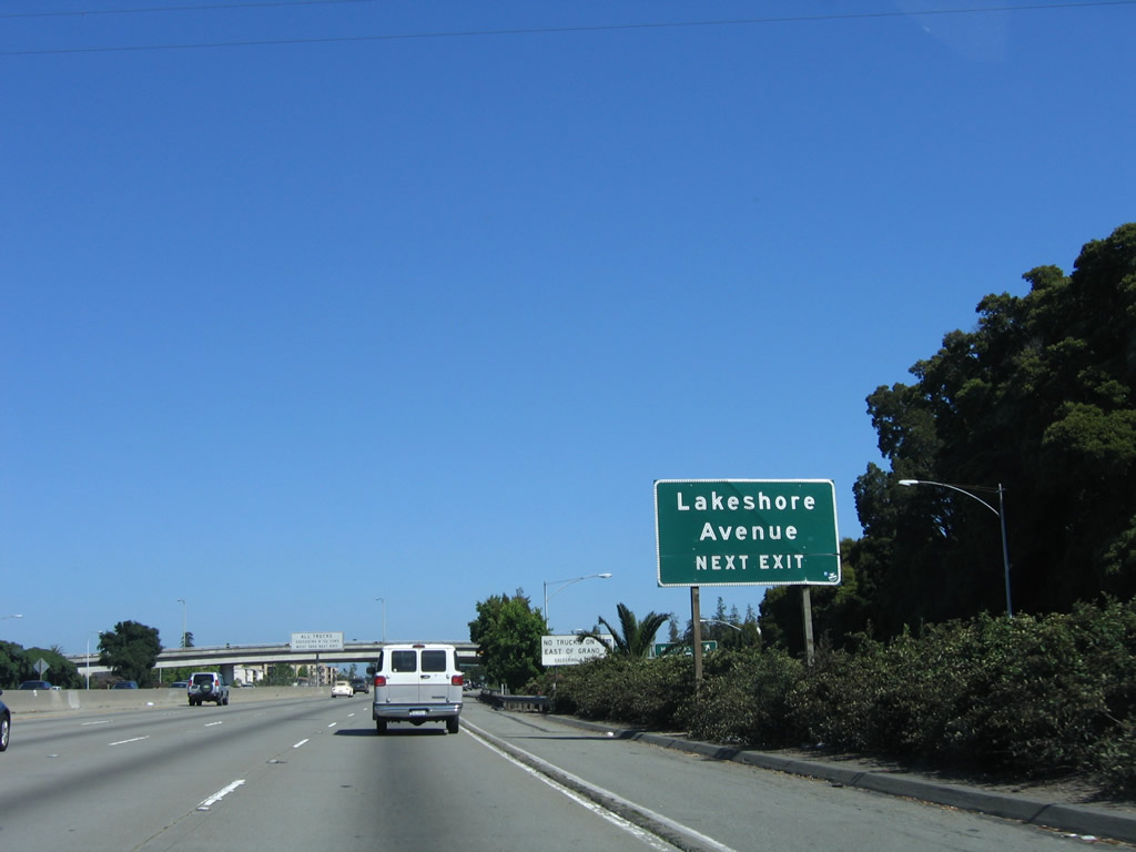
The next exit along Interstate 580 east is Exit 21B, Lakeshore Avneue and Grand Avenue (with a connection to MacArthur Boulevard). Photo taken 07/06/06. |
|
No trucks are permitted on Interstate 580 between Exit 21B, Lakeshore Avenue/Grand Avenue and Exit 31, MacArthur Boulevard. Trucks may use MacArthur Boulevard or Interstate 880 as alternate routes. Photo taken 07/06/06. |
|
Eastbound Interstate 580 reaches Exit 21B, Grand Avenue and Lakeshore Avenue. Grand Avenue is a major arterial that connects Interstate 580 with downtown Oakland to the west, then ends at the eastern approach to the San Francisco-Oakland Bay Bridge (near the Interstate 80 and Interstate 880 merge point). Lakeshore Avenue is a connector between Grand Avenue and International Boulevard along the east shore of Lake Merritt. On this set of porcelain enamel overhead signs, note the U.S. 50 shield that was covered up on the Interstate 580 pull-through sign. Pictures in California Highways and Public Works show that portions of Interstate 580/MacArthur Freeway were at one time signed in the field as Interstate 5W and U.S. 50. Photo taken 07/06/06. |
|
The next three exits along Interstate 580/MacArthur Freeway east is are Exit 22, Park Boulevard; Exit 23, Fruitvale Avenue; and Exit 24, 35th Avenue. Photo taken 07/06/06. |
|
Park Boulevard leads west to Lake Merritt and Lakeside Park. Eastbound Park Boulevard connects to Dimond Canyon Park in the community of Oakmore. During afternoon commuting hours, it is okay to use the right shoulder as a travel lane. This arrangement is a rarity in California. Photo taken 07/06/06. |
|
Traffic using the shoulder during daily commuting hours should merge onto the main lanes. Photo taken 07/06/06. |
|
Eastbound Interstate 580/MacArthur Freeway reaches Exit 22, Park Boulevard. Photo taken 07/06/06. |
|
The next three exits along eastbound Interstate 580/MacArthur Freeway are Exit 23, Fruitvale Avenue; Exit 24, 35th Avenue; and Exit 25A, High Street. Photo taken 07/06/06. |
|
Like many pull-through signs situated along the stretch of Interstate 580 between downtown Oakland and California 238, the signs are old enough (1964 and earlier) to have green overlay plates covering the original U.S. 50 shield. This sign, located on the approach to Exit 23/Fruitvale Avenue, is one such sign. Photo taken 07/06/06. |
|
Eastbound Interstate 580 reaches Exit 23, Fruitvale Avenue. Fruitvale Avenue travels south to Patten College, then connects with Interstate 880 (Nimitz Freeway) after passing through the Fruitvale neighborhood of the city of Oakland. Photo taken 07/06/06. |
|
This mileage sign provides the distance along eastbound Interstate 580 to the next three exits: Exit 24, 35th Avenue; Exit 25A, High Street; and Exit 25B, MacArthur Boulevard. Photo taken 07/06/06. |
|
The next exit along eastbound Interstate 580 is Exit 24, 35th Avenue. Photo taken 07/06/06. |
|
Eastbound Interstate 580 reaches Exit 24, 35th Avenue. Photo taken 08/23/03. |
|
The next exit along eastbound Interstate 580 is Exit 25A, High Street, 0.50 mile. Photo taken 07/06/06. |
|
High Street is a major east-west arterial that connects Interstate 580 with Interstate 880 (Nimitz Freeway) via the Fruitvale neighborhood of the city of Oakland. From there, High Street crosses the north edge of San Leandro Bay to enter the city of Alameda. Photo taken 07/06/06. |
|
Eastbound Interstate 580 reaches Exit 25A, High Street. Photo taken 07/06/06. |
|
MacArthur Boulevard, which predates Interstate 580 as the original routing of U.S. 50 through Oakland, connects with Interstate 580 at Exit 25B and Exit 31. The next exit is California 13 (Warren Freeway) north. Photo taken 07/06/06. |
|
The overhead signage for the continuation of Interstate 580 and the off-ramp to MacArthur Boulevard can be seen from the mainline freeway. Note the use of the old, two-digit sized shield for Interstate 580 on the porcelain enamel sign. Photo taken 07/06/06. |
|
This mileage sign along eastbound Interstate 580 provides the distance to the next exit, which is Exit 26, Seminary Avenue and California 13 (Warren Freeway). For some reason, the California 13 shield is omitted from this sign. As an alternate route to Interstate 580, California 13 swings to the east of downtown Oakland as a freeway, then reverts to a surface street as it passes through Berkeley. Photo taken 07/06/06. |
|
Eastbound Interstate 580 reaches Exit 26, California 13 (Warren Freeway) north and Seminary Avenue. Use this exit to Mills College, which is located southwest of Interstate 580 and is bounded by MacArthur Boulevard and Seminary Avenue. The next exit on Interstate 580 east is Exit 27A, Edwards Avenue. Photo taken 07/06/06. |
|
This flyover ramp carries California 13 (Warren Freeway) south over Interstate 580 east for the eventual merge point. Photo taken 07/06/06. |
|
The next exit on eastbound Interstate 580 is Exit 27A, Edwards Avenue. Photo taken 07/06/06. |
|
An Interstate 580 reassurance shield and scenic route marker are posted after traffic merges onto Interstate 580 from Seminary Avenue. Photo taken 07/06/06. |
|
Eastbound Interstate 580 reaches Exit 27A, Edwards Avenue. Photo taken 07/06/06. |
|
This interchange sequence sign along eastbound Interstate 580 provides the distance to Exit 27B, Keller Avenue/Mountain Boulevard; Exit 29A, Golf Links Road/98th Avenue; and Exit 29B, 106th Avenue/Foothill Boulevard. Photo taken 07/06/06. |
|
Eastbound Interstate 580/MacArthur Freeway reaches Exit 27B, Keller Avenue/Mountain Boulevard. The scenery changes a bit from urban to a more rural setting for the first time along eastbound. The Redwood Regional Park is located just to the northeast of Interstate 580, and it is accessible from Exits 27A-B and Exits 29A-B. Photo taken 07/06/06. |
|
Use Exit 29A, Golf Links Road east to Knowland Park, Oakland Zoo, and Knowland State Arboreteum. Exit 29A also serves as the connection to 98th Avenue, which travels west to Oakland International Airport. The 98th Avenue and Hegenberger Road corridors would potentially be routes for a southwesterly extension of California 13, but this extension is unlikely to be built (although it remains in the State Streets and Highways Code as a proposed state highway). Photo taken 07/06/06. |
|
Mileage sign along eastbound Interstate 580 approaches Exit 29A, Golf Links Road/98th Avenue. Photo taken 07/06/06. |
|
Another interchange sequence sign on eastbound Interstate 580/MacArthur Freeway provides the distance to Exit 29A, Golf Links Road/98th Avenue; Exit 29B, 106th Avenue/Foothill Boulevard; and Exit 31A, Estudillo Avenue/Dutton Avenue. Photo taken 07/06/06. |
|
Eastbound Interstate 580 reaches Exit 29A, Golf Links Road/98th Avenue. As the name implies, a few golf courses as well as an arboretum are accessible in the regional park to the east. 98th Avenue, meanwhile, heads west toward Oakland International Airport. Photo taken 07/06/06. |
|
Continuing east, another interchange sequence sign found on eastbound Interstate 580/MacArthur Freeway provides the distance to Exit 29B, 106th Avenue/Foothill Boulevard; Exit 31A, Estudillo Avenue/Dutton Avenue; and Exit 31B, Grand Avenue. Photo taken 07/06/06. |
|
Eastbound Interstate 580/MacArthur Freeway reaches Exit 29B, 106th Avenue/Foothill Boulevard. Photo taken 07/06/06. |
|
This interchange sequence sign along eastbound Interstate 580/MacArthur Freeway provides the distance to Exit 31A, Estudillo Avenue/Dutton Avenue; Exit 31B, Grand Avenue; and Exit 32, Fairmont Drive/150th Avenue. Photo taken 07/06/06. |
|
Interstate 580 leaves Oakland for the first time since splitting from Interstate 80. The freeway now enters the city of San Leandro. The next three exits all serve San Leandro: Exit 31A, Estudillo Avenue/Dutton Avenue; Exit 31B, Grand Avenue; and Exit 32, Fairmont Drive/150th Avenue. Photo taken 07/06/06. |
|
The next exit along Interstate 580 east is Exit 31A, Estudillo Avenue/Dutton Avenue to San Leandro. Photo taken 07/06/06. |
|
Eastbound Interstate 580/MacArthur Freeway reaches Exit 31A, Estudillo Avenue/Dutton Avenue. Photo taken 07/06/06. |
|
The city of San Leandro is home to 79,452 people per the 2000 Census. San Leandro is a southern suburb of Oakland, located between Oakland and unincorporated San Lorenzo. Incorporated as a town on March 21, 1872, San Leandro functioned briefly as the county seat of Alameda County prior to the 1868 Earthquake (when the courthouse at the intersection of Clarke Street and Davis Street was destroyed, and the county seat moved to Oakland). Photo taken 07/06/06. |
|
The next exit along Interstate 580 east is Exit 31B, Grand Avenue. This Grand Avenue is not the same as the one in Oakland, although it shares the same trajectory as the Oakland Grand Avenue. Photo taken 07/06/06. |
|
The Interstate 580 scenic route ends as the MacArthur Freeway approaches the Grand Avenue interchange. Photo taken 07/06/06. |
|
This interchange sequence sign along eastbound Interstate 580/MacArthur Freeway provides the distance to Exit 31B, Grand Avenue; Exit 32, Fairmont Drive/150th Avenue; and Exit 33, Miramar Avenue/164th Avenue. Photo taken 07/06/06. |
|
Eastbound Interstate 580 reaches Exit 31B, Grand Avenue. The next exit is Exit 32, Fairmont Drive/150th Avenue. Photo taken 07/06/06. |
|
An Interstate 580 reassurance shield assembly is posted shortly after the on-ramp from Grand Avenue. Photo taken 07/06/06. |
|
This mileage sign along eastbound Interstate 580 provides the distance to Exit 32, 150th Avenue and Fairmont Drive; Exit 33, 164th Avenue and Miramar Avenue; and Exit 34, California 238 south to Hayward and Interstate 238 west to Interstate 880. Photo taken 07/06/06. |
|
Use Exit 32 to Anthony Chabot Regional Park and Fairmont Ridge. Use Fairmont Drive west to the Alameda County Medical Center and the county department of health. At this interchange, Interstate 580 departs from the city of San Leandro and enters unincorporated Ashland. However, Fairmont Drive travels southwest back into the city of San Leandro. Photo taken 07/06/06. |
|
The next exit along eastbound Interstate 580 is Exit 32, 150th Street and Fairmont Drive, next right. Photo taken 07/06/06. |
|
Eastbound Interstate 580 reaches Exit 32, 150th Avenue and Fairmont Drive. Photo taken 07/06/06. |
|
Interstate 580 east passes under the 150th Avenue overpass. The next three exits are Exit 33, 164th Avenue/Miramar Avenue, followed by Exit 34, California 238 south and Interstate 238 west. After Exit 34, Interstate 580 turns due east, with the first exit being Exit 35, Strobridge Avenue. Photo taken 07/06/06. |
|
This Interstate 580 east shield assembly is posted after the on-ramp from 150th Avenue and Fairmont Drive. Photo taken 07/06/06. |
|
The next exit along eastbound Interstate 580 is Exit 33, 164th Avenue and Miramar Avenue, next right. Photo taken 07/06/06. |
|
Eastbound Interstate 580 reaches Exit 33, 164th Avenue and Miramar Avenue. Note the new reflective sign with exit number for Exit 34/California 238. Notably, Interstate 238 is not mentioned on this sign, even though Exit 34 leads to both Interstate 238 north (west) to Interstate 880 and California 238 (Foothill Boulevard) south to Hayward. Photo taken 07/06/06. |
|
To reach Interstate 880 and California 92/San Mateo Bridge westbound, use the northbound Interstate 238 exit (Exit 34). Both this roadside sign and the next sign (overhead) are difficult to read since there is a lot of information. It would be helpful to include Interstate 238 on this sign. Photo taken 07/06/06. |
|
For California State University-East Bay Campus at Hayward, use Exit 34, California 238 (Foothill Boulevard) south into Hayward. Photo taken 07/06/06. |
|
Another sign for Interstate 880 and California 92/San Mateo Bridge west is posted on Interstate 580/MacArthur Freeway east. Again note that Interstate 238 is not identified on this overhead sign. Photo taken 07/06/06. |
|
The right lane becomes exit only for California 238 (Foothill Boulevard) south to Hayward. Despite all the pull-through signs identifying Hayward as a control city for Interstate 580, the Interstate highway never enters the city of Hayward. Instead, the city lies south and west of the freeway. Photo taken 07/06/06. |
|
Now on the exit ramp for Exit 34, the right lane connects to Interstate 238 west to Interstate 880 and to California 92/San Mateo Bridge west. Photo taken 07/07/06. |
|
The Exit 34 ramp splits: the right lane goes to Interstate 238 west to Interstate 880 and to California 92/San Mateo Bridge west, and the left two lanes follow California 238 (Mission Boulevard) south to Hayward. On the perspective from Interstate 580 southeast, this is the only overhead sign assembly to show Interstate 238. Photo taken 07/07/06. |
|
Signage for Exit 35, Strobridge Avenue can be seen from the two-lane off-ramp to California 238. Photo taken 07/07/06. |
|
At the end of the two-lane off-ramp to California 238, the left lane prepares to turn onto Castro Valley Boulevard, while the two right lanes continue south onto California 238 (Mission Boulevard). Photo taken 07/07/06. |
|
As it passes through the massive Interstate 238/California 238 interchange, Interstate 580 narrows to two lanes. The next exit is Exit 35, Strobridge Avenue. Photo taken 08/23/03. |
|
Eastbound Interstate 580 reaches Exit 35, Strobridge Avenue. This exit is located on the ramp that carries Interstate 580 through the California 238/Interstate 238 interchange. Photo taken 08/23/03. |
| Interstate 580/Arthur H. Breed, Jr. Freeway east |
|
This mileage sign along eastbound Interstate 580 provides the distance to Exit 36A, Redwood Road; Exit 36B, Center Street/Crow Canyon Road; and Exit 39, Eden Canyon Road. An exit number sign was added in 2006 to show that Exit 36A also serves Anthony Chabot Regional Park and Lake Chabot via northbound Redwood Road. Photo taken 07/04/06. |
|
Redwood Road serves the unincorporated community of Castro Valley, the last development before Interstate 580 enters Dublin Canyon and enters the San Ramon Valley. Photo taken 07/04/06. |
|
Eastbound Interstate 580 reaches Exit 36A, Redwood Road. The Bay Area Rapid Transit rail follows the median of Interstate 580/Breed Freeway from the Interstate 238 interchange east to the city of Dublin at Exit 45, Hopyard Road/Dougherty Road. Photo taken 07/04/06. |
|
The next exit along eastbound Interstate 580 is Exit 36B, Center Street and Crow Canyon Road. The right lane becomes exit only for Exit 36B, while the left four lanes continue east on Interstate 580. Photo taken 07/04/06. |
|
Eastbound Interstate 580 reaches Exit 36B, Center Street and Crow Canyon Road. Crow Canyon Road connects Castro Valley with San Ramon and Interstate 680 in Contra Costa County. The off-ramp will connect to Center Street directly. To Crow Canyon Road, turn south on Center Street, then turn left on Grove Way, which changes into Crow Canyon Road. Photo taken 07/04/06. |
|
Interstate 580 is a designated truck safety corridor. Serving as the most direct route from San Francisco to the Central Valley and Interstate 5 south, the Breed Freeway section of Interstate 580 carries a great deal of truck traffic (as compared to the MacArthur Freeway portion, which has trucks prohibited in certain areas). Photo taken 07/04/06. |
|
This Interstate 580 reassurance shield is posted shortly after the on-ramp from westbound Grove Way and Crow Canyon Road. Photo taken 07/04/06. |
|
Another Interstate 580 reassurance shield is posted after the on-ramp from eastbound Grove Way. From here, the next exit is two miles east of here in Dublin Canyon. Photo taken 07/04/06. |
|
A mileage sign provides the distance to Livermore (17 miles) and Stockton (56 miles). Oddly, neither Tracy nor Fresno are mentioned ... and neither is Los Angeles, which is a popular destination for travelers en route to Southern California via Interstate 580 east to Interstate 5 south. This mileage sign is also unique for its distances converted into kilometers. Photo taken 07/04/06. |
|
The next three exits along eastbound Interstate 580 are Exit 39, Eden Canyon Road; Exit 44A, San Ramon Road (former California 21); and Exit 44B, Interstate 680 (Sinclair Freeway). Photo taken 07/04/06. |
|
The next interchange is Exit 39, Eden Canyon Road north and Palomares Road south. Eden Canyon Road travels northeast into Eden Canyon, but it is not a through road. To the south, Palomares Road travels along Palomares Creek, crosses Sunol Ridge, then follows Stonybrook Canyon to California 84 (Niles Canyon Road) in eastern Fremont. Photo taken 07/04/06. |
|
Eastbound Interstate 580/Breed Freeway reaches Exit 39, Eden Canyon Road and Palomares Road. Photo taken 07/04/06. |