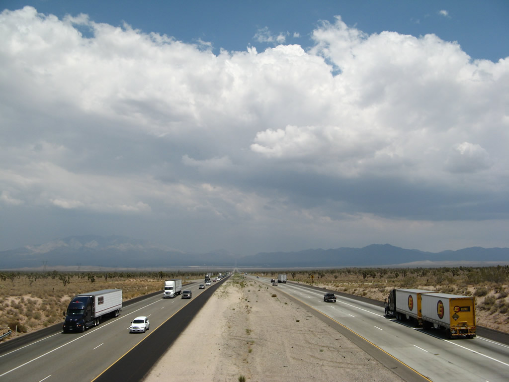
This view of Interstate 15 (Mojave Freeway) looks northeast from the Halloran Summit Road overpass in northeastern San Bernardino County. A summer monsoonal storm brews over Mountain Pass, which is the one of several summits along this section of I-15. The busy freeway carries a great deal of commercial and recreational traffic between Los Angeles, Las Vegas, and Salt Lake City. Photo taken 07/14/08.
| Interstate 15/Mojave Freeway north |
|
Immediately after the Interstate 40 exit, northbound Interstate 15/Mojave Freeway approaches Exit 184B, Business Loop I-15 (Main Street), in Barstow. Business Loop I-15 follows Old U.S. 66 southwest into downtown Barstow and east to meet Interstate 40 in eastern Barstow. Notably, the business route's northern terminus is located at Interstate 40 rather than Interstate 15. Photo taken 03/28/08. |
|
A roadside sign for Exit 184B, Main Street (Business Loop I-15 and U.S. 66) is posted shortly thereafter. This sign is now an exit number sign (see previous photobox). Photo taken 02/15/04. |
|
After passing under the transition ramp from Interstate 40 west to Interstate 15 south, this roadside sign for Exit 184B, East Main Street (Business Loop I-15 and U.S. 66) is posted. Photo taken 03/28/08. |
|
For the last time along northbound, Interstate 15 intersects Historic U.S. 66. From Barstow, U.S. 66 heads east along the National Old Trails Highway toward Needles and Flagstaff, while Interstate 15 angles northeast toward Las Vegas along the corridor once occupied by U.S. 91 and U.S. 466 en route to Las Vegas. Photo taken 03/28/08. |
|
Northbound Interstate 15 reaches Exit 184B, Business Interstate 15 and U.S. 66/East Main Street. Barstow is the last major city with services until Baker and Primm. Interstate 15 traverses some of the hottest and driest territory in the United States between here and Las Vegas. Photo taken 03/28/08. |
|
A pair of trains traveling in opposite directions pass over Interstate 15. Photo taken 03/28/08. |
|
A three-digit wide Interstate 15 reassurance shield is posted after the on-ramp from East Main Street. Photo taken 03/28/08. |
|
Interstate 15 carries two northbound lanes as it crosses the Mojave River again. The river flows northeast from the San Bernardino Mountains through Victorville (el. 2,715 feet) and Barstow (el. 2,106 feet), then turns northeast through Afton Canyon into the Mojave River Wash. During wet years, the river can connect to the Soda Dry Lake and Silver Dry Lake near Baker, which sits at a relatively low elevation of 923 feet. Due to its location in the desert, the Mojave River often looks dry. Photo taken 03/28/08. |
|
The next exit along northbound Interstate 15/Mojave Freeway is Exit 186, Junction Old Highway 58. Note the use of green overlays to cover up the California 58 shield on this sign. Photo taken 03/28/08. |
|
Old Highway 58 follows the old U.S. 91-466 alignment west along the north bank of the Mojave River. While U.S. 466 continues west along Old Highway 58 through Hutt to reconnect with California 58, U.S. 91 turned south on North First Avenue to connect with Historic U.S. 66 (Main Street) in downtown Barstow. Follow Old Highway 58 west to North First Avenue south to the historic Harvey House. Photo taken 03/28/08. |
|
Northbound Interstate 15 reaches Exit 186, Old Highway 58. This is the final exit to serve the city of Barstow. At one time, this interchange marked the point where U.S. 91 met U.S. 466, and U.S. 466 joined U.S. 91 for the rest of the drive into Las Vegas. This changed in 1964 when U.S. 466 was renumbered as California 58 west of Barstow, and the freeway was later constructed. Now that California 58 has been relocated south of Barstow, this interchange has been renamed Old Highway 58 (Exit 186). To avoid confusion with the modern California 58 freeway, they almost ought to call it Old U.S. 466! Photo taken 03/28/08. |
|
This mileage sign, which is partially obscured by a call box, provides the distance to Yermo (nine miles) and Las Vegas (151 miles). Photo taken 03/28/08. |
|
The next exit along Interstate 15/Mojave Freeway north is Exit 189, Fort Irwin Road. Use Fort Irwin Road north to the Fort Irwin National Training Center, which is a large federal government complex dedicated to training members of the Armed Forces on how to handle the desert. Photo taken 03/28/08. |
|
Fort Irwin is a national training center for the U.S. Army. Photo taken 03/28/08. |
|
Northbound Interstate 15 reaches Exit 189, Fort Irwin Road. An extant section of Old U.S. 91-466 serves as the frontage road between Exits 189 and 191, then follows Yermo Road into the community of Yermo. Photo taken 03/28/08. |
|
Passing by the gore point for Exit 189, Interstate 15 is traveling nearly due east at this point. In the distance, the United States Marine Corps Depot of Supplies Yermo Annex and the Solar Power Generating Station come into view. Photo taken 03/28/08. |
|
The next exit along northbound is Exit 191, Ghost Town Road, two miles. This sign was removed sometime between 2004 and 2008. Photo taken 02/15/04. |
|
This reassurance shield for Interstate 15 is posted after the on-ramp from Exit 189. Photo taken 03/28/08. |
|
Named after the Calico Ghost Town located north of the freeway, Exit 191 connects to Ghost Town Road. Ghost Town Road leads north to Calico Ghost Town Regional Park and south past the U.S. Marine Corps Depot of Supplies, over the Mojave River, through Daggett to the interchange with Interstate 40. Photo taken 03/28/08. |
|
A Southern California Edison 230kV power line passes over Interstate 15, carrying electricity from the solar power generating station to the transmission grid. This is the last tower of this design seen on Interstate 15 north. Photo taken 03/28/08. |
|
Use Ghost Town Road south to the U.S. Marine Corps Depot of Supplies Yermo Annex. Photo taken 03/28/08. |
|
The aforementioned solar electric generating plant gets its own sign on Interstate 15 north. Exit 191 has all motorist services: food, gas, and lodging. Photo taken 03/28/08. |
|
Northbound Interstate 15/Mojave Freeway reaches Exit 191, Ghost Town Road north to Calico Ghost Town and south to the Marine Base, Solar Electric Plant, and Daggett. Photo taken 03/28/08. |
|
The next exit along Interstate 15/Mojave Freeway north is Exit 194, Calico Road to Yermo. Photo taken 03/28/08. |
|
Calico Road travels south from Exit 194 into downtown Yermo, an unincorporated community of San Bernardino County. Calico Road ends at Yermo Road, which is Old U.S. 91-466 through town. Turn north on Calico Road toward Calico Ghost Town. Photo taken 03/28/08. |
|
Northbound Interstate 15/Mojave Freeway reaches Exit 194, Calico Road to Yermo. Photo taken 03/28/08. |
|
A nice Interstate 15 reassurance shield is posted after the on-ramp from Calico Road. Photo taken 03/28/08. |
|
The next exit along Interstate 15/Mojave Freeway north is Exit 196, Yermo Road. This interchange connects Interstate 15 with Old U.S. 91-466/Yermo Road west into Yermo and east along the Interstate 15 frontage road (all the way northeast to Exit 213, Field Road). Photo taken 03/28/08. |
|
Northbound Interstate 15 reaches Exit 196, Yermo Road. Photo taken 03/28/08. |
|
The State of California agricultural inspection station comes into view soon after the Yermo Road interchange. While the inspection station is only in operation for southbound traffic, it is common to see delays for southbound traffic after passing by the inspection station. This station is planned to be relocated closer to Primm at the California-Nevada state line in 2009. Photo taken 03/28/08. |
|
The next exit along Interstate 15 north is Exit 198, Minneola Road. Minneola Road leads north to the Calico Early Man Archaeological Site and south over the Mojave River to Minneola, which is located off Interstate 40/U.S. 66 west of Newberry Springs. Photo taken 03/28/08. |
|
Northbound Interstate 15/Mojave Freeway reaches Exit 198, Minneola Road. Photo taken 03/28/08. |
|
Interstate 15/Mojave Freeway passes under Minneola Road. Photo taken 03/28/08. |
|
|
The group of 287, 500, and -500kV power lines again cross Interstate 15 after Exit 198 (Minneola Road). The first two lines are the two 500kV Los Angeles Department of Water and Power's McCullough - Victorville transmission line (part of Path 46/West of Colorado River, Arizona-California West-of-the-River Path [WOR]. The third line is the 287kV Hoover - Victorville line. The last tower of the four is Path 27, the -500kV Intermountain High Voltage Direct Current (HVDC) transmission line (hence two bundles of wires rather than three bundles, which is typical of alternating current power lines). Photos taken 03/28/08. |
|
|
|
This mileage sign along northbound Interstate 15 provides the distance to Baker (48 miles) and Las Vegas (140 miles). Photo taken 03/28/08. |
|
This view along Interstate 15 shows the expansive Mojave Desert. Interstate 15 will remain in rural areas from Barstow to Primm, Nevada. On Friday afternoons or holiday weekends, Interstate 15 can be jammed with traffic traveling to Las Vegas. When traveling, be sure to listen for traffic reports. Additionally, the hot summer months are oppressive, and during slowed traffic, vehicle overheating can occur. Bring plenty of water before making this trip. Photo taken 03/28/08. |
|
The next exit along Interstate 15/Mojave Freeway north is Exit 206, Harvard Road, one mile. Photo taken 03/28/08. |
|
Harvard Road leads south over the Mojave River and through Mojave Valley, then connects to Newberry Road, which in turn leads to Newberry Springs. Newberry Springs is situated along Interstate 40/Old U.S. 66 due south of here. Photo taken 03/28/08. |
|
Northbound Interstate 15 reaches Exit 206, Harvard Road. Photo taken 03/28/08. |
|
An Interstate 15 north reassurance shield is posted after the on-ramp from Exit 206, Harvard Road. Photo taken 03/28/08. |
|
This mileage sign along northbound Interstate 15 again provides the distance to Baker and Las Vegas. Photo taken 03/28/08. |
|
The vast Mojave Desert spreads out in front of northbound travelers, with the Mojave River flowing seasonally alongside the freeway to the south. The Mojave River does not extend beyond the dry lakes near Baker, and it does not drain to the Colorado River. Photo taken 03/28/08. |
|
The next exit along northbound is Exit 213, Field Road. Field Road leads south to meet old U.S. 91, which merges back into Interstate 15 at this interchange. Photo taken 02/15/04. |
|
Northbound Interstate 15 reaches Exit 213, Field Road. Yermo Road, which has paralleled Interstate 15 from Yermo, merges back onto the freeway at this interchange (so there is no alternate to Interstate 15 through the upcoming stretch. Photo taken 03/28/08. |
|
|
This Interstate 15 shield is located at Postmile 104 along northbound, which means we are 104 miles north of the San Bernardino-Riverside County Line (Ontario city limits). Interstate 15 spends more time in San Bernardino County than any other county in California. Photos taken 03/28/08 and 02/15/04. |
|
The next exit along northbound is Exit 217, a rest area. This is the second to last rest area along northbound; the last one is located just prior to Exit 272, Cima Road. Photo taken 03/28/08. |
|
|
Northbound Interstate 15 reaches Exit 217, Rest Area. This rest area exit features an exit number, which is unlike most other rest area exits in California. Photos taken 03/28/08. |
|
|
The Path 64 500kV power line comes into view for the first time on Interstate 15 north. This particular line (also owned by Los Angeles Department of Water and Power, just like the Path 46 and Path 27 power lines seen earlier) will closely parallel Interstate 15 from here northeast to Primm. Path 64 is also known as the Marketplace-Adelanto (or Mead-Adelanto) transmission line, which is approximately 202 miles long. Beginning at the Adelanto Switching Station, Path 64 travels north generally along the U.S. 395 corridor, then turns northeast toward the Interstate 15 corridor. It will travel northwest into Nevada toward Boulder City, ending at the Marketplace Substation.1 Photos taken 03/28/08. |
|
The next exit along northbound is Exit 221, Afton Road. The diamond interchange is visible in the distance. Afton Road leads east into Afton Canyon (where it connects to Basin Road) and northwest to the Arrowhead Trail. Photo taken 03/28/08. |
|
Northbound Interstate 15/Mojave Freeway reaches Exit 221, Afton Road. Photo taken 03/28/08. |
|
After passing under the Afton Road overpass, a safety corridor sign is posted for Interstate 15. Due to the traffic volume, desert heat in summer, and speed of traffic, this road can be a dangerous drive. Photo taken 03/28/08. |
|
An Interstate 15 north reassurance shield is posted shortly after the on-ramp from Afton Road. Photo taken 03/28/08. |
|
Interstate 15 through the Mojave Desert is one of the busier four-lane freeways in the state due to the never-ending stream of traffic between Los Angeles and Las Vegas, even though the freeway passes through mostly unpopulated areas. Interstate 5, the Westside Highway in the Central Valley, is a close competitor for busiest four-lane freeway. Photo taken 03/28/08. |
|
|
|
Northbound Interstate 15 curves again as it pulls through the Cronese Mountains. A mileage sign for Baker (24 miles) and Las Vegas (116 miles) is posted shortly thereafter. The freeway is traveling mostly northeast at this point. Photos taken 03/28/08. |
|
|
The Path 64 (Adelanto to Marketplace) 500kV power line again crosses Interstate 15, and the freeway pulls out of the Cronese Mountains. Photos taken 03/28/08. |
|
|
|
Soon thereafter, the traffic breaks up a bit, which affords a beautiful late-day view of the Cronese Valley and the Soda Mountains. Photos taken 03/28/08. |
|
The next exit along northbound is Exit 230, Basin Road. Photo taken 03/28/08. |
|
Northbound Interstate 15/Mojave Freeway reaches Exit 230, Basin Road. There are no services at Exit 230, although Basin Road travels south from Interstate 15 to Afton Canyon (through which passes the often-dry Mojave River). Photo taken 03/28/08. |
|
An Interstate 15 reassurance shield is posted shortly after the Basin Road interchange. This kind of three-digit wide reassurance shield is fairly common along Interstate 15 through the Mojave Desert. Photo taken 03/28/08. |
|
Interstate 15 stays southeast of the Soda Mountains, south of West and East Cronese Lakes, and north of Cave Mountain as the freeway gains elevation. Photo taken 03/28/08. |
|
The next exit along northbound Interstate 15 is Exit 233, Rasor Road. This exit leads southeast toward the Rasor Off Highway Vehicle (OHV) offroad area and Devils Playground. Photo taken 03/28/08. |
|
Northbound Interstate 15/Mojave Freeway reaches Exit 233, Rasor Road. Photo taken 03/28/08. |
|
This reassurance shield for Interstate 15 is posted after the Rasor Road interchange as the freeway skirts the southern edge of the Soda Mountains. This shield, which again is wider than typical reassurance shields, leaves a bit of white paint on the original post that holds up this sign. The rest of the white paint has since peeled off the wooden post. Photo taken 03/28/08. |
|
A mileage sign provides the distance to Baker (11 miles) and Las Vegas (103 miles). Photo taken 03/28/08. |
|
The next exit along northbound Interstate 15/Mojave Freeway is Exit 239, Zzyzx Road. This road is unique for its name that is very close to if not at the end of the alphabet. As much as AAA might be at the top of phone book's yellow pages, Zzyzx Road would be at the bottom. Photo taken 03/28/08. |
|
Northbound Interstate 15 reaches Exit 239, Zzyzx Road south to the settlement of Zzyxz. At Zzyzx is the former Zzyzx Mineral Springs and Health Spa (1944-1974) operated by Curtis Howe Springer; it is now the site of the California State University's Desert Studies Center.2 In the distance, the first hint of dry Soda Lake appears as the freeway approaches the Zzyzx Road interchange. Photo taken 03/28/08. |
|
An older Interstate 15 reassurance shield is posted shortly after the Zzyzx Road interchange. Photo taken 03/28/08. |
|
Soda Lake, which spends much of its time dry, sprawls in the valley below. The Mojave River ends its flow into this giant dry lake, but water only reaches the dry lake during years of flood or unusually high rainfall in the dry desert. From here, Interstate 15 will descend toward the community of Baker, which rests on the floor of the valley next to the northern end of Soda Lake. Photo taken 03/28/08. |
|
The freeway bends a bit to the north as Interstate 15 approaches Baker. Photo taken 03/28/08. |
|
Information about the Mojave National Preserve is again available via radio (tune to AM 1610). Photo taken 03/28/08. |
|
During 2008, the rest area northeast of Baker was being reconstructed and was closed at the time this picture was taken. All traffic needing to use the facilities are thus encouraged to exit at Baker. Photo taken 03/28/08. |
|
Another Interstate 15 safety corridor sign is posted as the freeway continues to descend toward Baker. Photo taken 03/28/08. |
|
The next exit is Exit 245, Baker Boulevard northeast into the community of Baker (west entrance). This is old U.S. 91-466 and should be signed as a business loop, but there are no signs or shields suggesting a business route through Baker is or was present. Baker, with a population of 914 per the 2000 Census, sits at an elevation of 930 feet and is the last full-service freeway exit until entering Nevada. Another 45 miles of isolated territory remains between Baker and Primm, Nevada. Between Baker and Primm, Interstate 15 will skirt the northwestern edge of the Mojave National Preserve. Photo taken 03/28/08. |
|
One of the popular attractions in the Mojave National Preserve is the town of Kelso, which is located along the railroad line between Barstow and Las Vegas. Use Exit 246, Kelbaker Road southeast to Kelso and its historic train depot. Photo taken 03/28/08. |
|
The next two exits (Exit 245, Baker Boulevard and Exit 246, California 127 (Kelbaker Road) north) serve the community of Baker. The Path 64 500kV power lines, which discretely follow Interstate 15 on the northwest side of the freeway, stay northwest of Baker as well. Photo taken 03/28/08. |
|
Northbound Interstate 15 reaches Exit 245, Baker Boulevard. All motorist services are available in Baker. The boulevard functions as a business loop between Exits 245 and 247, but the intended business loop (Old U.S. 91-466) is completely unsigned. The original porcelain enamel overhead sign was partially covered by a newer reflective sign that does not provide the exit number. Photo taken 03/28/08. |
|
The next exit on Interstate 15/Mojave Freeway north is Exit 246, California 127 north to Baker and Kelbaker Road to Kelso and the Mojave National Preserve. Photo taken 03/28/08. |
|
A Baker population and elevation sign is posted prior to the flyover ramp connecting Interstate 15 north with Old Historic U.S. 91-466 (Baker Boulevard) northeast. Photo taken 03/28/08. |
|
Prior to passing under the transition ramp, a variable message sign and speed limit sign are posted along Interstate 15/Mojave Freeway north. Watch for changing conditions on the freeway due to weather (ice, dust, storms, or fog) or traffic (heavy use or accidents). Photo taken 03/28/08. |
|
Use California 127 north to downtown Baker, Shoshone, and Death Valley National Park. Shoshone is nearly an hour's drive north of Baker along California 127, and it is one of the gateways into Death Valley National Park, with connections from California 127 north to California 178 west or California 190 west. After meeting California 190, California 127 crosses into Nevada and changes into Nevada 373 (which ends at U.S. 95 in Amargosa Valley, Nevada). Photo taken 03/28/08. |
|
Situated at the north end of Soda Lake, this bridge carries Interstate 15 over the lake, which is signed as the Mojave River. Soda Lake has a connection to Silver Lake via the dry Mojave River between this point and a point north of the Baker Airport along California 127. Note the lack of shoulders on this older bridge. Photo taken 03/28/08. |
|
Northbound Interstate 15 reaches Exit 246, California 127 north to Baker and Kelbaker Road southeast to Kelso. A tourist information center for the national preserve is located in Kelso. Follow California 127 north to the various services available in Baker, which is the only town for an hour's drive in either direction along Interstate 15. Photo taken 03/28/08. |
|
The World's Tallest Thermometer can be seen from the northbound lanes of Interstate 15 prior to the California 127 overpass. The thermometer is located near the Big Boy Restaurant, which was formerly the Bun Boy Restaurant. Photo taken 03/28/08. |
|
There is no access from Interstate 15 north to Exit 247, Baker Boulevard (east entrance). The next interchange is Exit 259, which is 13 miles northeast of Baker. Leaving Baker, Interstate 15 also pulls away from the last civilization it will see until the state line. Interstate 15 enters Mojave National Preserve, which encompasses a large swath of land bounded by Interstate 15 in the northwest, Interstate 40 on the south, and the Nevada state line on the east. Photo taken 03/28/08. |
|
|
Interstate 15 takes a few significant climbs between Baker and Primm. The first of these is the long ascent to Halloran Summit. After the on-ramp from Baker Boulevard east, Interstate 15 gains a third lane for trucks that eases the climb up Halloran Summit (between Exits 247 and 265). Photos taken 03/28/08. |
|
This mileage sign provides the distance to Las Vegas (89 miles) and for the first time, Salt Lake City (534 miles). Photo taken 03/28/08. |
|
With the long ascent to Halloran Summit (at Exit 265), motorists are encouraged to turn off their air conditioning to avoid overheating. Photo taken 03/28/08. |
|
On the ascent, the right lane functions as a climbing lane for trucks and other slow vehicles. The left two lanes are for faster traffic. This lane striping is relatively rare elsewhere, but it is common along this section of Interstate 15. Photo taken 03/28/08. |
|
|
Another overhead Truck Lane sign is posted thereafter, as Interstate 15 continues its climb up Halloran Summit. Photos taken 03/28/08. |
|
|
Interstate 15 clears 2,000 feet as the freeway climbs away from Baker (the elevation gain is now over 1,000 feet). A third overhead Truck Lane sign is posted thereafter. Photos taken 03/28/08. |
|
Interstate 15 between Baker and Halloran Summit was completely reconstructed in 2004 to accommodate a longer truck lane and concrete lanes. Another mileage sign provides the distance to Las Vegas (81 miles) and Salt Lake City (526 miles). Photo taken 03/28/08. |
|
The next exit is Exit 259, Halloran Springs Road (one mile). Photo taken 03/28/08. |
|
Northbound Interstate 15/Mojave Freeway reaches Exit 259, Halloran Springs Road. Halloran Springs Road leads north to Turquoise Mountain and Squaw Mountain. It is still another six miles to Halloran Summit. Photo taken 03/28/08. |
|
Another truck lane sign is posted on the Halloran Springs Road overpass; in the distance, the 3,000-foot elevation sign is posted on Interstate north. Photo taken 03/28/08. |
|
|
|
Continuing the climb toward Halloran Summit, the freeway retains three northbound lanes after the Halloran Springs interchange. The Hollow Hills rise on the northwest side of the freeway, and the Path 64 500kV power lines are still visible on the northwest side of the freeway. Now in excess of 3,000 feet, Joshua Trees come into view on both sides of the freeway. Photos taken 03/28/08. |
|
The next exit along Interstate 15/Mojave Freeway north is Exit 265, Halloran Summit Road. Photo taken 03/28/08. |
|
Northbound Interstate 15 reaches Exit 265, Halloran Summit Road. Halloran Summit Road is located immediately after Halloran Summit (el. 4,000 feet). The construction zone to expand the roadway to six lanes comes to an end after this interchange. Photo taken 03/28/08. |
|
Upon passing under the Halloran Summit Road overpass, Interstate 15 reaches Halloran Summit at an elevation of over 4,000 feet. From here, Interstate 15 descends into Shadow Valley. Photo taken 03/28/08. |
|
Now descending, the truck lane ends on Interstate 15 north after the Halloran Summit interchange. Photo taken 03/28/08. |
|
An "end truck lane" sign is posted at the point where the three northbound lanes merge back into two northbound lanes. Photo taken 03/28/08. |
|
Another mileage sign provides the distance to Las Vegas (72 miles) and Salt Lake City (517 miles). Omitted from any of these signs is the distance to Primm at the California-Nevada state line, which is the next interchange with motorist services. Photo taken 03/28/08. |
|
An elevation 4,000 feet sign is posted on the descent from Halloran Summit. Photo taken 03/28/08. |
|
The next exit along northbound Interstate 15/Mojave Freeway is Exit 270, Rest Area. This rest area was closed in 2008 for reconstruction; it is located at the bottom of the grade from Halloran Summit into Shadow Valley. Photo taken 03/28/08. |
|
Northbound Interstate 15/Mojave Freeway reaches Exit 270, Valley Wells Rest Area. This rest area was closed in 2008 for reconstruction. A new truck climbing lane begins here; this third lane will enable trucks to climb from Shadow Valley to Mountain Pass (el. 4,730 feet). Photo taken 03/28/08. |
|
The next exit along Interstate 15/Mojave Freeway north is Exit 272, Cima Road (one mile). This is the only interchange within Shadow Valley. Cima Road leads southeast to Cima, where it meets the railroad. Cima-Kelso Road then heads south to Kelso. Photo taken 03/28/08. |
|
This reassurance shield is posted after the on-ramp from the rest area. Photo taken 03/28/08. |
|
Northbound Interstate 15/Mojave Freeway reaches Exit 272, Cima Road south through the Shadow Valley to Cima and Kelso. Photo taken 03/28/08. |
|
Interstate 15 continues with three northbound lanes after Cima Road as it ascends Mountain Pass. The freeway will lose its third lane after the truck brake inspection area and prior to the Bailey Road interchange (Exit 281). Photo taken 03/28/08. |
|
Interstate 15 turns from northeast to due east for its ascent up Mountain Pass. This is the last major ascent on Interstate 15 in California. Mountain Pass separates the Clark Mountain Range with the Mescal Range; Mountain Pass brings Interstate 15 to an elevation of 4,730 feet, and the freeway then will descend toward Ivanpah Dry Lake and Primm. The old alignment of U.S. 91-466 (Arrowhead Trail), which is generally not passable through this area, remains on the west side of Interstate 15 and may be visible. Photo taken 03/28/08. |
|
The tall peaks on the north side of eastbound (northbound) Interstate 15 are Clark Mountain (el. 7,929 feet) and Mohawk Hill (el. 5,971 feet). Mountain Pass separates these peaks (which are part of the Clark Mountain Range) from the Mescal Range, which is on the south side of the freeway. Photo taken 03/28/08. |
|
Interstate 15 again rises past 4,000 feet in elevation. Photo taken 03/28/08. |
|
Another truck lane overhead sign is posted on Interstate 15 north. Photo taken 03/28/08. |
|
This mileage sign provides the distance to Las Vegas (60 miles) and Salt Lake City (505 miles). Photo taken 03/28/08. |
|
At Mountain Pass, there is a brake check area for trucks prior to descending into Primm. Photo taken 03/28/08. |
|
The downgrade on Interstate 15 north from Mountain Pass to Yates Well Road (Exit 291) lasts ten miles. Photo taken 03/28/08. |
|
A cluster of trucks and vehicles lie ahead as Interstate 15 continues its ascent to Mountain Pass. Photo taken 03/28/08. |
|
The brake check area is one-half mile ahead. After the brake inspection area, Interstate 15 will begin its descent toward Primm. Photo taken 03/28/08. |
|
An exit gore point sign is posted at the truck brake inspection area on Interstate 15/Mojave Freeway north near Mountain Pass. Photo taken 03/28/08. |
|
The truck lane ends after the on-ramp from the truck brake inspection area and prior to the next exit, which is Exit 281, Bailey Road. Photo taken 03/28/08. |
|
Interstate 15 enters the community of Mountain Pass, elevation 4,730 feet. Photo taken 03/28/08. |
|
Northbound Interstate 15 reaches Exit 281, Bailey Road. This exit provides access to Mountain Pass and connects to some extant sections of U.S. 91-466/Arrowhead Trail. Photo taken 03/28/08. |
|
Interstate 15 begins its long descent toward Ivanpah Dry Lake and Primm. A runaway truck ramp is located four miles ahead (after the on-ramp from Bailey Road and Mountain Pass). Photo taken 03/28/08. |
|
An Interstate 15 north reassurance shield is posted shortly thereafter. Photo taken 03/28/08. |
|
|
|
Watch for curves, rock slides, and heavy traffic on this section of Interstate 15/Mojave Freeway north. Photos taken 03/28/08. |
|
The runaway truck ramp is two miles ahead. Photo taken 03/28/08. |
|
At the 4,000-foot elevation sign on the downgrade from Mountain Pass is an unsigned, unpaved off-ramp providing ranch access. Photo taken 03/28/08. |
|
This caution sign warns of potential danger for downhill motorists due to excessive speed, weather conditions, or traffic. Photo taken 03/28/08. |
|
Northbound Interstate 15 approaches the off-ramp to the runaway truck ramp in one-half mile. Photo taken 03/28/08. |
|
The next exit along northbound Interstate 15/Mojave Freeway is Exit 286, Nipton Road east to Nevada 164 to Searchlight. Nipton Road leads east to Nipton, then enters Nevada. Upon crossing the state line, it becomes Nevada 164, then heads east to meet U.S. 95 in Searchlight, which is located midway between Boulder City and Laughlin. Photo taken 03/28/08. |
|
Ivanpah Dry Lake comes into view as Interstate 15 meets the off-ramp for runaway trucks. Photo taken 03/28/08. |
|
Use Nipton Road east to Searchlight, Nevada. At the California-Nevada state line, county-maintained Nipton Road becomes Nevada 164, which passes through a Joshua Tree forest at the south end of the McCullough Mountains, then descends to Searchlight. Photo taken 03/28/08. |
|
Nipton Road also serves the northern access points into Mojave National Preserve. Photo taken 03/28/08. |
|
Northbound Interstate 15 reaches Exit 286, Nipton Road east to Nevada 164 and Searchlight, Nevada (where Nevada 164 meets U.S. 95). At this point, Interstate 15 turns northeast again and is no longer traveling due east. Photo taken 03/28/08. |
|
A magnificent view of the Ivanpah Valley, Ivanpah Dry Lake, and Primm is afforded on Interstate 15 north after the Nipton Road interchange. Primm, Nevada, which is located on the California-Nevada state line, was constructed built entirely for gambling and shopping. At night, the view of Primm is much more prevalent due to the neon and lights associated with the various casinos. It is almost a shock at night to see such lights after miles of dark desert driving, but this view is nothing compared to the view coming into Las Vegas at night. Photo taken 03/28/08. |
|
The brown dry lake bed is clearly visible on the descent from Mountain Pass. This lake occasionally fills with water, but not most days. Interstate 15 passes across the dry lake but is rarely flooded. Photo taken 03/28/08. |
|
Interstate 15 descends to 3,000 feet as Ivanpah Dry Lake and Primm loom closer. Photo taken 03/28/08. |
|
A final California mileage sign provides the distance to Las Vegas (51 miles) and Salt Lake City (496 miles). Photo taken 03/28/08. |
|
The next exit along Interstate 15/Mojave Freeway north is Exit 291, Yates Well Road (one mile). During evening and night, the lights of Primm shine brightly in the distance, beckoning road weary travelers to stop and gamble at the first resorts before reaching Las Vegas. Photo taken 03/28/08. |
|
Northbound Interstate 15 reaches Exit 291, Yates Well Road. It is another five miles from here until reaching the stateline and Exit 1, Primm. Primm is a relatively new Nevada city, having been known as Stateline until the mid-1990s. Since there was another town named Stateline at the border between California and Nevada adjacent to South Lake Tahoe, the Stateline here was renamed as Primm. Photo taken 03/28/08. |
|
A final Interstate 15 California shield is posted on northbound as the freeway crosses the Ivanpah Dry Lake after the Yates Well Road interchange. Photo taken 03/28/08. |
|
No vegetation grows on the floor of Ivanpah Dry Lake. The freeway retains two northbound lanes for the remaining distance to Primm. Photo taken 03/28/08. |
|
This view shows Ivanpah Dry Lake looking east from Interstate 15. Photo taken 03/28/08. |
|
Path 64, which has been generally following Interstate 15, crosses the freeway for a final time prior to entering Primm, Nevada. Photo taken 03/28/08. |
|
A land vehicle pushed by a wind sail comes into view on the bed of the dry lake as we approach Primm. Photo taken 03/28/08. |
|
The next exit is Exit 1, Primm. A Nevada Welcome Center is located at this interchange (although it was closed in March 2008). Photo taken 03/28/08. |
|
Primm (formerly known as Stateline until 1996 to avoid confusion with Stateline near South Lake Tahoe) is an unincorporated community within Clark County, Nevada. It is named for casino owner Ernest Jay Primm. Three major casinos are located in Primm: Buffalo Bill's, Primm Valley Resort, and Whiskey Pete's. Photo taken 03/28/08. |
|
A "line in the sand" separates California desert from Primm, Nevada. The Desperado roller coaster (visible in the background) is located at Buffalo Bill's and is well-known stop for visitors seeking a thrill ride. An outlet mall (foreground), restaurants, hotels, and other facilities are also located in Primm, making this a full-service stop. It is approximately 40 miles from Primm to downtown Las Vegas. Photo taken 03/28/08. |
|
Casinos, shopping, restaurants, and gas are located on both sides of the freeway. A tram connects the casinos over Interstate 15. This is the first step into a whole different world when compared to the Mojave National Preserve south of here. Photo taken 03/28/08. |
|
Interstate 15 leaves the state of California and enters the state of Nevada. Known as the Silver State because of its history of mining precious metals throughout the state, Nevada became a state on October 31, 1864 (the 36th state to enter the union). Nevada has a total area of 110,567 square miles (seventh largest state) and currently has a population of 1,998,257 (2000 Census). Most Nevada counties allow gambling, including Clark County in southern Nevada. Photo taken 03/28/08. |
Page Updated March 7, 2010.