
The beginning of a week plus trip that took us northward from Delaware/Philadelphia to Boston for several days and from there to Lake Champlain in Vermont for a 5-day vacation…
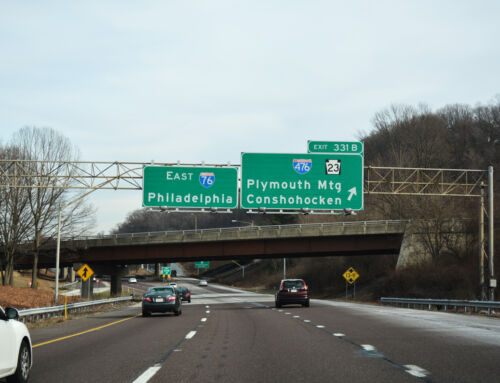
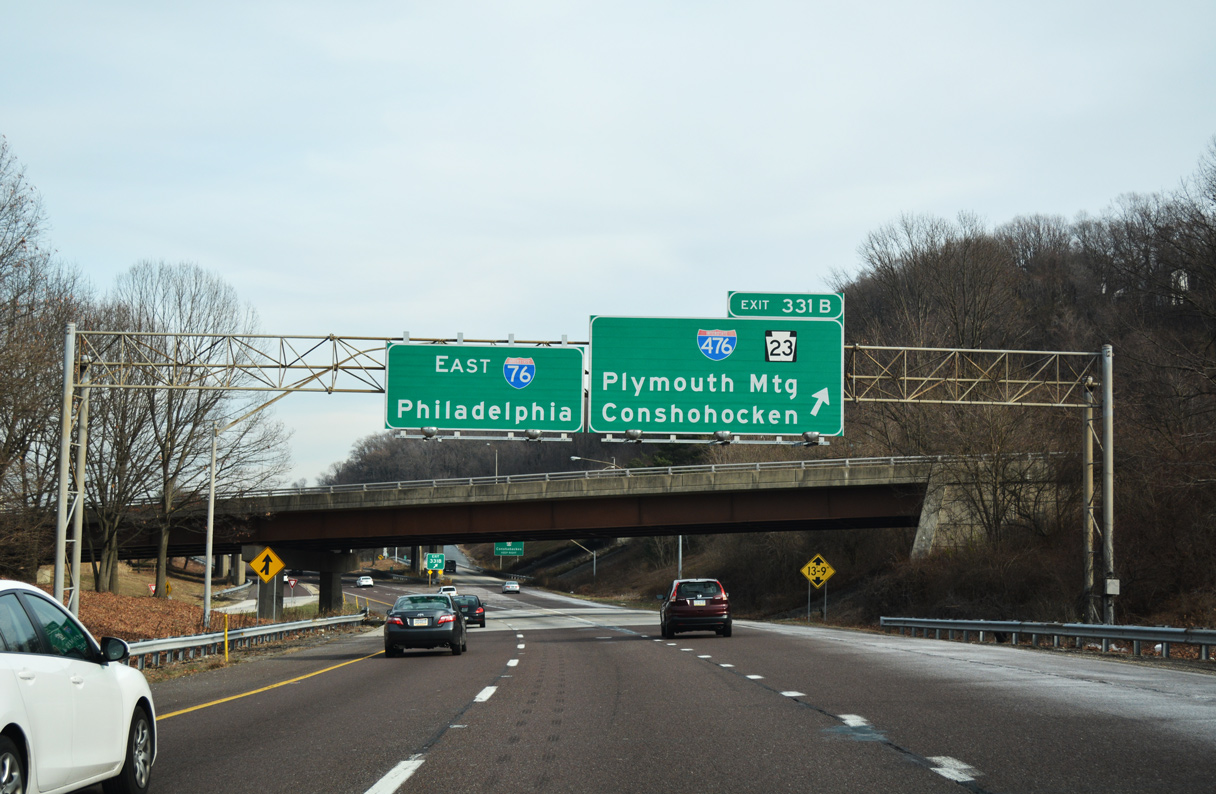
We started our journey just south of the Pennsylvania state line, beginning first with a visit to the Pennsylvania Welcome Center to obtain the latest copy of the Pennsylvania State Highway Map. Construction is present along all of Interstate 95 in Delaware County between the state line and junction Interstate 476. PennDOT is in the process of again resurfacing the highway with asphalt. At the time, the previous coat of asphalt was milled down to the original concrete roadway. This project would hamper us a over a week later with a 30-minute back-up at 11 pm on a Saturday night…
Continuing east into New Jersey, we entered the New Jersey Turnpike by way of New Jersey 168, the only connection between the toll road and parallel Interstate 295 close enough to act as the junction between the Turnpike and Interstate 76/New Jersey 42 (North South Freeway). New Jersey 168 offers two lanes laden with traffic lights on the short drive between the respective interchanges. There are no plans to provide a direct connection between the two pivotal roads in South Jersey…
Northward, Turnpike travelers heading southbound this day (Friday July 27) were greeted with what seemed to be a 15-20 mile back-up between the Pennsylvania Turnpike Extension and New Brunswick. It was unclear as to what caused the congestion, but the Turnpike does reduce from a four-carriageway configuration into a six-lane freeway on this stretch.
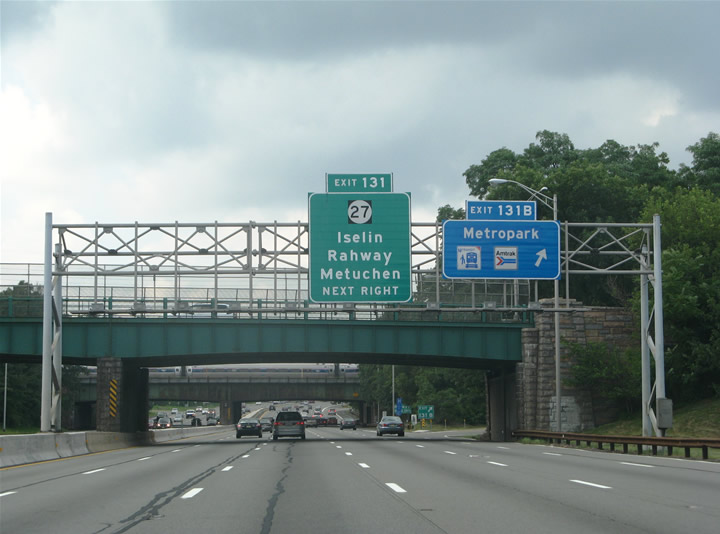
Garden State Parkway northbound at the Metrowest trumpet interchange (Exit 131B) near Iselin. The Parkway is untolled between the New Jersey Turnpike and a point just south of junction Interstate 78. Several button copy signs remain in use along this stretch of freeway.
Eastward, we opted for the Holland Tunnel into Lower Manhattan and Canal Street southeast to the Manhattan Bridge. The Manhattan Bridge is historical in nature as far as Interstates are concerned as it was one time planned to be a part of Interstate 478 between the unconstructed Lower Manhattan Expressway (Interstate 78) and Interstate 278 (Brooklyn-Queens Expressway). As it exists, the Manhattan Bridge carries seven lanes of traffic and four Metro tracks; vehicles partition between separate two lane upper carriageways on the outside of the suspension bridge span and a three-lane lower carriageway on the inside of the bridge. Since Interstate 78 was never built east of the Holland Tunnel, Interstate 478 was removed from the Manhattan Bridge and reapplied on the nearby Brooklyn Battery Tunnel in an unsigned fashion. The Manhattan Bridge along with the Brooklyn and Queensboro Bridges are the only three untolled spans across the East River between Manhattan and Brooklyn/Queens.
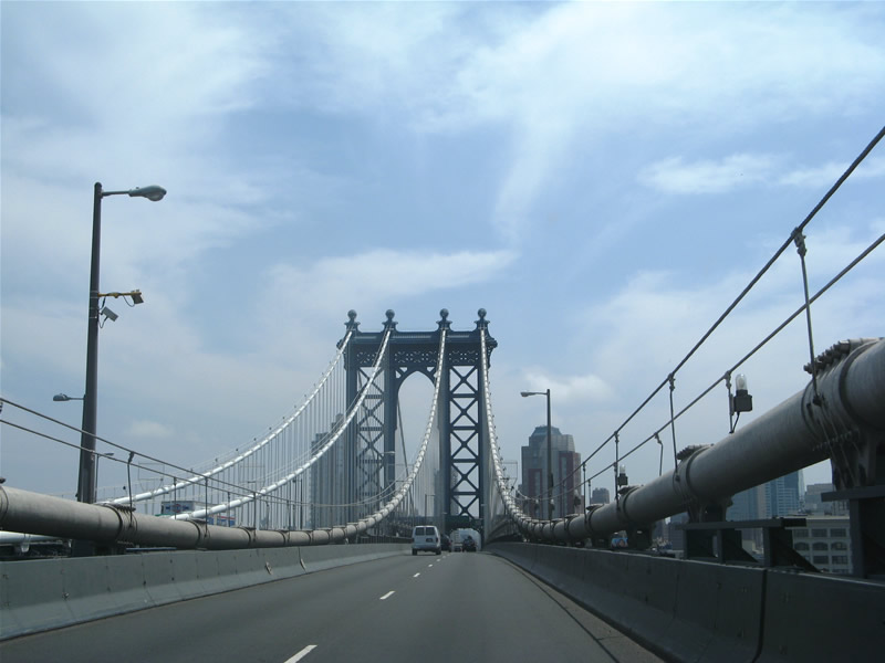
Southbound on the upper carriageway or the Manhattan Bridge. Like other Manhattan area bridges, no shoulders or break-down lanes are provided. The span ends at Tillary Street in Brooklyn on the south side with connections provided to Interstate 278 (Brooklyn-Queens Expressway) via surface streets (Jay Street north / Sand Street east).
A brief jaunt southward took us to the Brooklyn Battery Tunnel northbound onto FDR Drive. FDR Drive represents a north-south freeway along the eastern periphery of Manhattan Island between Battery Park at the south and junction Interstate 95 (George Washington Bridge) and the Washington Bridge (West 181st Street) to the north. This freeway passes under several high-rises along its journey, including a portion of the United Nations Building. As with many Manhattan and New York City freeways, the northernmost two miles were accompanied with a 20-minute back-up caused by congestion on the George Washington Bridge to New Jersey.

FDR (Franklin Delano Roosevelt) Drive northbound initially travels southbound from West Street and the Brooklyn Battery Tunnel portal southward underneath Battery Park. The configuration allows for an usual situation where two subterranean roadways pass over one another.
After a few turns in the Bronx, including a short stretch along the poorly signed U.S. 1, we ended up on Interstate 87 (Major Deegan Expressway / New York Thruway) north to Interstate 287. Interstate 87 was clogged northbound leading to its interchange with Interstate 95 (because of the GWB again), but was free flowing north to Interstate 287 (Cross Westchester Expressway). At this point it was after 3 pm, and traffic volume showed it. All of westbound Interstate 287 between Interstate 87 and Interstate 95 was jammed and Interstate 95 northbound from the Connecticut line was similarly slow-moving. VMS along the former toll road indicated “Delay Next 25 miles to Exit 24 ” and later “Delay Six Miles Exits 41 – 48”. It was simply amazing to encounter more or less 50 miles of traffic delays, a sad accepted situation on a pivotal stretch of road. Total time to traverse 50 miles of I-95 in CT, 1 hour and 45 minutes…
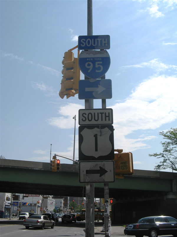
U.S. 1 (Webster Avenue) southbound at its turn onto Interstate 95 (Cross Bronx Expressway) southbound. U.S. 1 follows Interstate 95 across the George Washington Bridge into Fort Lee, New Jersey. An original state-named shield joins a weathered U.S. 1 trailblazer at the Webster Avenue intersection with Ittner Place and the on-ramp.
Construction is a factor and will be for several more years at the south end of Interstate 91 and the Q Bridge (Pearl Harbor Memorial Bridge) at New Haven, Connecticut. Work focuses on the east side of the Q Bridge at present in preparation for the bridge replacement project. Work to upgrade the Interstate 91 and 95 interchange is schedule to commence in 2009. Fortunately however the widening of Interstate 95 through Bridgeport is complete, and the brief eight-lane segment there (Exit 26 to 27A) allowed for a brief reprieve from the otherwise congested ride.
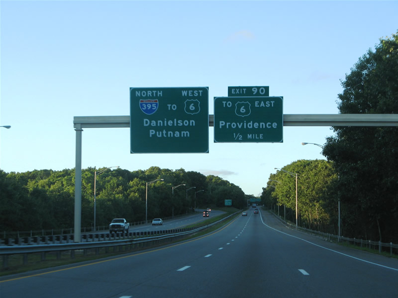
Interstate 395 northbound nearing the split with the Connecticut Turnpike (Exit 90). Interstate 395 continues north to Putnam and Worcester, Massachusetts. The Turnpike spurs east as unsigned Connecticut 395 to junction U.S. 6 near the Rhode Island state line. Had Interstate 84 been construction between Hartford, Connecticut and Providence, Rhode Island as envisioned, it would have utilized the east-west Turnpike spur between Interstate 395 and the state line.
Once east of New Haven, traffic flow increased dramatically, though volumes remained somewhat high. We opted for Interstate 395 northeast to Worcester, Massachusetts. As mentioned in Justin’s May 10, 2007 blog post, MassHighway is presently upgrading the Massachusetts 146 roadway into an expressway connection with Interstate 290 in Worcester, a $300-million project begun in 2004.
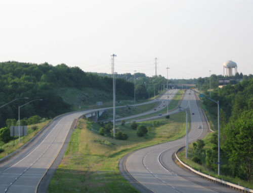
Heading northbound on Interstate 290 east at the Massachusetts 146 interchange in Worcester. Massachusetts 146 northbound drivers will be provided a direct ramp onto Interstate 290 east and drivers bound for Massachusetts 146 south to Interstate 90 will be provided a direct southbound off-ramp via I-290 west.
The direct connection (via a wye interchange) replaces a traffic rotary previously located under Interstate 290 at Massachusetts 146. Massachusetts 146 subsequently will continue north along Quinsigamond Avenue to an end at Southbridge Street.
That project is one element of the Massachusetts 146/Massachusetts Turnpike interchange project, work that will upgrade four miles of Massachusetts 146 between Interstate 290 and Interstate 90. See the map below for additional elements of the project.
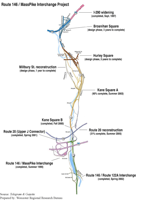
Massachusetts 146 reconstruction and upgrade map, courtesy of Worcester Regional Research Bureau.
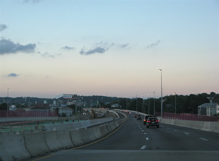
After nightfall, our routing took us east via Interstate 290, Interstate 495, Interstate 90 (Massachusetts Turnpike) and Interstate 93 to Quincy, our destination for the weekend.
Sources:
- “Riveting work.” Worcester Telegram & Gazette Online, January 25, 2004.
- “Worcester’s Link to the Masspike: An Update on the Route 146 Connector.” Worcester Regional Research Bureau, March 2003.
Nice work, I bet its nice to be back in the south where there is no traffic….
*rimshot*
I’ve lived in the New York City metro area for all of my 46 years and never knew that the Manhattan bridge was to be a part of I-78. This was a very interesting piece. Thanks.
Actually the Manhattan Bridge was to be apart of Interstate 478; Interstate 78 was to cross the Williamsburg Bridge with the unconstructed Lower Manhattan Expressway joining the two.