

U.S. 93 travels across the western reaches of Montana 288 miles north from Chief Joseph Pass (7,264 feet) to the Canadian border at the Port of Roosville. Heading north from Gibbonsville, Idaho, U.S. 93 winds alongside Camp Creek and then the East Fork of the Bitteroot River to Darby and the south end of a wide valley between the Bitteroot and Sapphire Mountains.
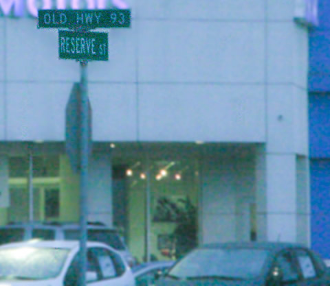
Leading north, U.S. 93 travels through Hamilton and Lolo with a pair of four-lane segments to the merge with U.S. 12 east toward Missoula. Once in Missoula, U.S. 93 splits with a Business route that follows the original alignment to Downtown while the mainline bypasses the city along a commercial arterial (Reserve Street) to the west. A 5.5 mile long overlap with I-90/MT 200 take the route northwest from Missoula.
MT 200 departs I-90 for a 28 mile long overlap with U.S. 93 north to Arlee and Ravalli. A multi state route leading west from Minnesota, MT 200 continues west to Dixon, Plains and Thompson Falls while U.S. 93 continues north to St. Ignatius, Ronan, Pablo and Polson at Flathead Lake. The US highway encircles the west side of the lake to Somers while MT 35 provides a direct route north to Bigfork and Creston for interests to Glacier National Park.
U.S. 93 expands to four lanes northwest from MT 82 into the city of Kalispell. The route currently follows Main Street north to Downtown and U.S. 2 (Idaho Street). U.S. 2 enters Kalispell from Libby to the east and exits along a four lane corridor to Columbia Falls for Glacier National Park. Sunset Boulevard carries U.S. 93 northward to exit the city at Flathead Valley Community College. The route retains four lanes to 13th Street in Whitefish.
Following Spokane Avenue, U.S. 93 enters the residential street grid of Whitefish to 2nd Street west through Downtown. The US route climbs west out of town to mirror the Stillwater River northward to Olney and Stryker. Through northern Lincoln County, U.S. 93 follows the Tobacco River to Eureka and ranch land north from there to the Port of Entry at Roosville.
Kalispell Bypass
U.S. 93 will shift away from Kalispell upon completion of the Kalispell Bypass to the west of the city. An Environmental Impact Statement (EIS) underway between 1992-94 for U.S. 93 from Somers to West of Whitefish considered alternatives for U.S. 93, including the Kalispell Bypass to the west of the city. The west bypass was recommended in October 1993 by the Kalispell Transportation Plan and Bypass Feasibility Study. A Record of Decision (ROD) followed and was approved in November 1994 for the West Kalispell Bypass as the preferred alternative.1
Design work was underway involving six projects for the U.S. 93 upgrade from Somers to Whitefish by the Montana Department of Transportation (MDT) in 1996. Construction contracts were awarded for MT 40 - South and Grandview North in April 1996 and for MT 40 - North in June of 1997. Work continued in 1999 with the Somers - Ashley Creek - South project kicking off and Somers - Ashley Creek - North in May 2000.1
Construction for the expansion of U.S. 93 as part of the Ashley Creek - Kalispell project was awarded in February 2004. Preliminary design for the Kalispell Bypass followed a re-evaluation of the 1994 EIS for the Bypass portion of the overall project. Initial work for the bypass commenced in September 2006, leading to widening of 1.2 miles of U.S. 93 at the north end of the future bypass (Reserve Loop) in 2007.1
The bypass was constructed from 2008 to Fall 2010 with a series of interim projects to build a two lane at-grade roadway from a point 3.5 miles south of Downtown to U.S. 2 on the west side of town. Roundabouts exist at Siderius Road, Airport Road and Foys Lake Road, with interchanges proposed at both Airport and Foys Lake Road in the future.1
The northern half of the Kalispell Bypass, under construction as of Fall 2013, ties into U.S. 93 by the Spring Prairie Center retail area at an at-grade intersection with West Reserve Drive north of the city. The roadway will include a diamond interchange with Reserve Loop near Glacier High School, a half diamond interchange at Three Mile Drive and a full diamond at U.S. 2.1
U.S. 93 Business - Missoula
U.S. 93 was commissioned in 1928 by AASHTO, and its original route through Missoula runs along Brooks Street, Stephens Avenue, Orange Street and Broadway Street. This alignment today carries U.S. 93 Business coupled with Interstate 90 Business.2
From 1929 to late 1999/early 2000, U.S. 93 served the industrial sections of Missoula. A set of gantries along Interstate 90 Business (Broadway Street) suggests the prior movement from Brooks Street, Stephens Avenue, and Orange Street to Reserve at the time of the relocation. Additionally a 1999 USGS topography image indicates US 93's prior movement, along the former U.S. 10 corridor heading due southeast to Orange Street. A 2002 satellite image suggests the completion of the westward shift from Brooks Street, Stephens Avenue and Orange Street to its current designation along Reserve Street.2
Approval was given to MDT to designate U.S. 93's original movement along Brooks, Stephen and Orange as U.S. 93 Business and to relocate U.S. 93 onto the southern extension of Reserve Street from the intersection of Mullan Road (Secondary Highway 263) south to 39th Street. The Mullan Road intersection has seen numerous reconfigurations since U.S. 93 was shifted to Reserve Street. Today, U.S. 93 along Reserve Street is the most traveled corridor as a major link between U.S. 12 at Brooks Street to the south and Exit 101 at Interstate 90 to the north on the south end of Grant Creek.2
U.S. 93 Montana Guides
 North North |
 | An erroneous U.S. 200 shield accompanies this reassurance assmembly along U.S. 93 north after the pair depart Interstate 90 west from Exit 96. 08/28/13 |
| South |
 | A second U.S. 200 shield posted at the parclo interchange with Interstate 90. U.S. 93 south / MT 200 east split with Broadway Street / Highway 10 West ahead of S-474 for an overlap with the freeway east into Missoula. 08/28/13 |
| South |
 | U.S. 93 passes by Larchmont Golf Course ahead of the turn southwest alongside U.S. 12 (Brooks Street) to Lolo. 11/24/13 |
 | Brooks Street northeast from Reserve Street doubles as both U.S. 12 and U.S. 93 Business. A Business supplement banner was added to this trailblazer after U.S. 93 shifted to Reserve Street during the extension south to Brooks Street. 11/24/13 |
| scenes |
 | Stephens Avenue north at the split of U.S. 12 east and U.S. 93 Business (Brooks Street) north in Missoula. Signs placed here refer to Stephens Avenue north and Brooks Street west as the U.S. 93 mainline, which it was until the route shifted onto Reserve Street to the west. 12/30/12 |
 | U.S. 93 shield assembly posted along Secondary Highway 474 (Pulp Mill Road) east ahead of Broadway Street. 02/22/13 |
 | S-474 (Pulp Mill Road) east at Broadway Street (former U.S. 93/MT 200) with new signal heads and mast arms installed late Spring 2013. The parclo interchange where U.S. 93/MT 200 join I-90 east lies just north of the truck stop. 05/23/13 |
 | One of the destination panels on the mastarm that faces S-474 (Pulp Mill Road) at the Crossroads Travel Center. The top pointing left refers to U.S. 93/MT 200, the bottom pointing right refers to Old U.S. 10/Old U.S. 93 along Broadway Street heading to the airport. 05/23/13 |
 | Trailblazers pointing to Interstate 90, U.S. 93 and MT 200 at the apex of the intersection between S-474 and Broadway Street (Old U.S. 10). These new signs were added during the signal installation project of late Spring 2013. 05/23/13 |
- KALISPELL BYPASS - Project History.
http://kalispellbypass.com/hist1.cfmKalispell Bypass US 93 Alternate, project web site. - Fortner, Billy.
Photo Credits:
12/30/12, 02/22/13, 05/23/13, 08/28/13, 11/24/13 by Billy Fortner
Connect with:
Interstate 90
Business Loop I-90 - Missoula
U.S. 12
Page Updated 11-26-2013.