
U.S. 60 East - Florence Junction to Show Low

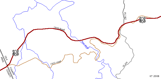
This map shows the original 1922 alignment of U.S. 60, and the 1949 reroute of the road. Note the extreme curvature of the historic route that was bypassed during the reroute. This 1949 route is being investigated for possible replacement as it does not meet current ADOT Highway Standards.
 East
East
Just east of SR 79, US 60 reverts to a two lane, undivided highway, and will stay that way until reaching Superior. This section of road is being reconstructed.
11/11/06

Distance sign to Superior and Globe.
11/11/06

Turn left here to reach Queen Valley Road and Whitlow Dam. Whitlow Dam is a flood control dam on Queen Creek, which US 60 parallels.
11/11/06

US 60 has many curves along Queen Creek. This section of road was first constructed in 1929, and rebuilt between 1948 and 1952.
11/11/06

This is a typical view of two lane US 60 west of Superior.
11/11/06

US 60 snakes alongside Queen Creek Canyon. A passing lane is just ahead, one that has been added after original construction.
11/11/06

Even with a passing lane, US 60 snakes along the canyon wall, limiting the utility of the passing lane. US 60 is climbing eastbound as it approaches Superior.
11/11/06

Just west of Superior is a rest area. Superior is an old siver mining town, which switched to copper with the opening of the Magma Copper mine. Mining activity has all but ceased in recent years.
11/11/06

US 60 meets SR 177. SR 177 travels south to Kearny and Winkleman, and was added to the state highway system in 1953.
11/11/06

SR 177 and US 60 meet at a grade-separated interchange.
11/11/06

The grade separated interchange was constructed in 1955, shortly after SR 177 became a state highway.
11/11/06

The reconstructed US 60 passes through numerous road cuts, cut from the sheer rock faces above Queen Creek.
11/11/06

The Queen Creek Bridge was completed in 1953. This 651 foot long steel arch bridge is typical of many in Arizona completed during the 1940s and 1950s.
11/11/06

In 1952, the Queen Creek Tunnel was completed. This 1280 foot long tunnel was designed for four traffic lanes, but is currently striped for three. The maximum clearance in the tunnel is 14 feet. This tunnel replaced the shorter 1921 Claypool Tunnel.
11/11/06

US 60 passes under sheer road cuts just to the north of the road.
11/11/06

US 60 is the Gila-Pinal Scenic Road between Miles 214.5 and 240.5. The road is signed with the Arizona standard scenic road marker, as seen here.
11/11/06

Turn right here for the Oak Flat Campground. The campground is part of the Tonto National Forest.
11/11/06

US 60 meets Magma Mine Road here. US 60 passes the Magma Copper Mine, which closed in 1987. There are talks about reopening the mine, but the plans are controversial as they would require loss of some recreational areas, such as Oak Flat.
11/11/06

US 60 follows the lay of the land as it continues north and east to Miami.
11/11/06

Directional markers are rare along US 60 between Superior and Miami.
11/11/06

Distance sign to Miami and Globe. US 60 is traveling through Gila County at this point.
11/11/06

US 60 has alternating passing lanes along the road, as seen here facing eastbound (with the passing lanes on the westbound side).
11/11/06

US 60 crosses Pinto Wash here. The Pinto Wash arch bridge was completed in 1949, bypassing the original road which was significantly more windy and longer than the present alignment. The Pinto Wash bridge was voted the most beautiful steel bridge of 1949, as seen by the plaque on the bridge.
11/11/06

US 60 follows Bloody Tanks Wash to Miami. Bloody Tanks wash is named for the nearby Bloody Tanks, which are named after a battle between white men and the Apaches in 1864.
11/11/06

The canyon that holds Bloody Tanks Wash gets very deep as it nears Miami.
11/11/06

US 60 enters Miami here. Miami is a town that grew up around the copper mines near town, with the town founded to serve the needs of the miners. Tailings from the Freeport McMoran (Phelps-Dodge) mine surround the hills north of town.
11/11/06

US 60 passes under the stack of the Miami copper smelter.
11/11/06

East of Miami, US 60 enters Globe. Globe is the county seat of Gila county, and was supposedly named for a silver sphere found that was approximately 9" of diameter, that resembled a globe.
11/11/06

US 60 meets SR 188 at this intersection. Use SR 188 to reach Roosevelt Dam and Tonto National Monument.
11/11/06

Globe is the home of former Governor Rose Mofford, Arizona's first female governor.
11/11/06

This is a typical US 60 reassurance marker as seen in Globe.
11/11/06

The next road junction US 60 meets is US 70 and SR 77, in 1/2 mile.
11/11/06

Interestingly, through traffic on US 60 must turn to stay on US 60, while the main road becomes US 70. This is a legacy of the original construction of US 60 between 1929 and 1934, when US 70 was the only through route at this point. US 70 was co-signed with US 60 until 1969 on this road.
11/11/06

SR 77 continues east on US 70, then branches south to reach Oracle and Tucson. Traffic on US 60 and SR 77 north should use the left lane.
11/11/06
East  North
North
Now north of Globe, US 60 and SR 77 climb away from the city quite rapidly.
11/11/06

Distance sign to Show Low and Springerville. US 60 will cross some rugged terrain between Globe and Springerville.
11/11/06

North of Globe, US 60 passes through additional road cuts as it climbs in elevation.
11/11/06

US 60 north of Globe is much less heavily trafficked then it was between Phoenix and Globe.
11/11/06

Scrubby hills are common around Globe. This type of brush cover is common in the high desert mountains.
11/11/06

Advance signage for Jones Water Campground. Jones Water Campground is part of the Tonto National Forest, and is a small, primitive campground (no water available).
11/11/06

US 60 has various stretches of passing lanes through the mountains.
11/11/06

US 60 and SR 77 remain co-signed north of Globe, as seen on this sign assembly.
11/11/06

"Don't Drink and Drive" signs are commonly placed on rural highways in Arizona.
11/11/06

Distance sign to Show Low and Springerville.
11/11/06

Advance signage for a Safety Pullout. Arizona places Safety Pullouts before long downhill grades.
11/11/06

US 60 meets the ghost town of Seneca here. Seneca was a town established to support the nearby mines, but it has all but been abandoned.
11/11/06

Distance sign to the aforementioned safety pullout, 1/2 mile.
11/11/06

This advisory sign advises trucks and vehicles pulling trailers to check their brakes before heading down into the Salt River Canyon.
11/11/06

After the pullout, this sign advises motorists to use lower gears if they are a truck or pulling a trailer. It's a wild ride ahead, and a long way down to the bottom.
11/11/06

US 60 enters the Salt River Canyon here.
11/11/06

This photo is rather deceptive, as US 60 will have a 6% grade for the next five miles. However, all motorists see right now are mountains on the horizon, not knowing about the canyon between here and the other side.
11/11/06

US 60 travels through a number of roadcuts ahead, as warned by this sign (advising to watch for rocks).
11/11/06

In the 1990s, a runaway truck ramp was added. This sign advises motorists of the runaway truck ramp ahead.
11/11/06

Unfortunately, if stuck behind a truck, it will make your ride a lot longer to the canyon bottom. The two trucks seen here were traveling approximately 20 MPH.
11/11/06

These photos were taken from an abandoned rest area on an old alignment of US 60, and have an excellent view of the grade and the twin Salt River bridges at the bottom of the canyon.
11/11/06

These photos were taken of the runaway truck ramp, as approaching it northbound.
11/11/06

The descent into the Salt River Canyon is a wild ride, and photos do not do it justice.
11/11/06

The Salt River Bridge was built in 1933-34, with the parallel replacement bridge (red) built in 1994. These photos were taken from the rest area at the bottom of the canyon.
11/11/06

After crossing the new bridge, US 60 turns to follow the base of a small (relatively speaking) cliff. The old gas station and mini-mart located here is now closed.
11/11/06

Distance sign to Show Low and Springerville, the next two cities along US 60.
11/11/06

US 60 gains a climbing lane as it climbs along the north side of the Salt River Canyon.
11/11/06

US 60 climbs quickly along the north canyon wall, as seen here.
11/11/06

Climbing up toward Becker Lookout, the road pulls back and passes through some road cuts, similar to this one.
11/11/06

Becker Lookout was named for Walter Becker, described as the father of US 60. Becker was one of the pioneers who lived in this area in the 1920s, and his work led to the designation of US 60 as a transcontinental highway. His work communicating road surfaces and traffic counts led to the establishment of US 60, and this lookout is dedicated to his memory, along with that of his son.
11/11/06

At the top of the canyon, the scenery changes dramatically.
11/11/06

US 60 continues to twist and turn as it makes the final climb out of the Salt River Canyon, into high mountainous terrain.
11/11/06

US 60 remains co-signed with SR 77 as it reaches the top of the Mogollon Rim.
11/11/06

US 60 continues through the scrub-covered lands of northeastern Arizona.
11/11/06

Advance signage for SR 73.
11/11/06

SR 73 is the original road up through the Fort Apache Indian Nation, with the majority replaced by US 60. The present-day road begins here and travels through Fort Apache, Hon Dah and White River to SR 260.
11/11/06

SR 73 departs here from US 60. SR 77 and US 60 continue north to Show Low from this point.
11/11/06

Photo Credits:
- Kevin Trinkle: 11/11/06
Connect with:
Page Updated Monday June 30, 2008.