|
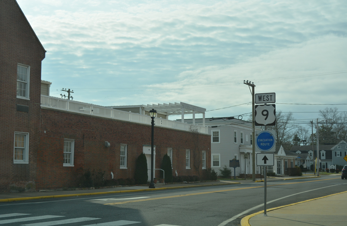
| This sign directs motorists exiting the Lewes Terminal of the ferry onto Cape Henlopen Drive east to the state park and west toward Five Points, where SR 1 and SR 404 lead motorists to long distance destinations. 06/18/12 |
|
| Facing west on Cape Henlopen Drive, U.S. 9 leaves the ferry area and quickly approaches the split with U.S. 9 Business. U.S. 9 Business extends Cape Henlopen Drive west to Savannah Road and the Lewes historic area. 06/18/12 |
|
| Older signage posted along U.S. 9 west ahead of U.S. 9 Business included the control point of Norfolk, Virginia. Norfolk was also routinely referenced for U.S. 13 leading south from Interstate 295. April 2000 |
|
| U.S. 9 Business extends Cape Henlopen Drive west to Lewes Beach, where it turns southwest on Savannah Road. 06/18/12 |
|
| U.S. 9 turns southwest along Theo C. Freeman Memorial Highway to bypass Downtown Lewes to Kings Highway. 06/18/12 |
|
| Reassurance marker posted for U.S. 9 west between Cape Henlopen Drive and a railroad crossing north of the Lewes and Rehoboth Canal. 06/18/12 |
|
| A multitude of control points appear on this distance sign along with a Chesapeake Bay Bridge-Tunnel trailblazer. The Cape May-Lewes Ferry provides an alternate route from the Northeast to the Delaware Beaches, the Eastern Shore of Maryland and Hampton Roads, Virginia. 06/18/12 |
|
| Theo. C. Freeman was a NASA Astronaut who attended the University of Delaware. He died during a training flight on October 31, 1964. 06/18/12 |
|
| Crossing the Lewes and Rehoboth Canal along U.S. 9 (Theo. C. Freeman Memorial Highway) west. 06/18/12 |
|
| Monroe Avenue provides a second route into Lewes from U.S. 9 west. 06/18/12 |
|
| U.S. 9 approaches the merge with Kings Highway south of Monroe Avenue. 06/18/12 |
|
| Kings Highway branches south from U.S. 9 Business (Savannah Road) and Downtown Lewes to become a part of U.S. 9 south. 06/18/12 |
|
| U.S. 9 follows Kings Highway south to Dartmouth Drive. 06/18/12 |
|
| Gills Neck Road ties into U.S. 9 (Kings Highway) opposite the entrance to Cape Henlopen High School at this signal. 06/18/12 |
|
| U.S. 9 splits with Kings Highway for Dartmouth Drive to make the connection with SR 1 (Coastal Highway). Kings Highway branches east to end nearby. 06/18/12 |
|
| U.S. 9 west combines with SR 1 north for a 1.1 mile overlap to Five Points. SR 1 travels north from the Atlantic beaches to Milford, Dover and the Wilmington area while connections with SR 404 lead motorists west toward Annapolis. 06/18/12 |
|
| SR 1 constitutes a congested commercial arterial route from Five Points southeast to Rehoboth Beach. The state route straddles the coast south from Dewey Beach to Ocean City, Maryland otherwise. 06/18/12 |
|
| Westbound U.S. 9/SR 404 (Lewes Georgetown Highway) at Sweetbriar Road. This intersection was upgraded during a HSIP project between March 2014 and November 2015. 12/17/17 |
|
| Reassurance shield assembly posted for U.S. 9/SR 404 west of Harbeson. 01/16/17 |
|
| Entering the settlement of Gravel Hill, U.S. 9/SR 404 (Lewes Georgetown Highway) approach SR 30 (Gravel Hill Road). Including SR 30, Construction between March 2014 and November 2015 improved three intersections along U.S. 9 to add bicycle and turn lanes and make geometry shifts. 01/16/17 |
|
| SR 30 constitutes a rural route from Gravel Hill north toward Milton and Milford and south to Zoar and Millsboro. 01/16/17 |
|
| U.S. 9/SR 404 (Lewes Georgetown Highway) westbound pass by a number of industrial businesses and forest stands over the ensuing 1.5 miles. 01/16/17 |
|
| Trucks bound for U.S. 9 west or SR 404 west beyond Georgetown are directed onto U.S. 9 Truck as it bypasses the east and south sides of the Sussex County seat to U.S. 113. 01/16/17 |
|
| Shown here as overlapped with SR 404, U.S. 9 Truck travels solo along a combination of Park Avenue and Bedford Streets southwest to U.S. 113 (Dupont Boulevard). 01/16/17 |
|
| U.S. 9 Truck loops south from Lewes Georgetown Highway to return to U.S. 9 alongside U.S. 113 (Dupont Boulevard) north in 4.19 miles. 01/16/17 |
|
| U.S. 9/SR 404 west at U.S. 9 Truck (Park Avenue) west. Park Avenue comprises a rural route southwest around Delaware Coastal Airport (GED) to Bedford Street. 01/16/17 |
|
| Leading west from U.S. 9 Truck and Saulsbury Switch, U.S. 9/SR 404 continue 1.3 miles to join Market Street through Georgetown. 01/16/17 |
|
| U.S. 9/SR 404 westbound make an S-curve across the Georgetown corporate limits ahead of Airport Road. 01/16/17 |
|
| Airport Road angles southeast to Delaware Coastal Airport (GED). Sand Hill Road ties into the intersection with U.S. 9/SR 404 (Market Street) from rural Sand Hill to the north. 01/16/17 |
|
| Speed limits reduce to 25 miles per hour as Market Street curves into the Georgetown street grid ahead of Albury Avenue. 01/16/17 |
|
| U.S. 9/SR 404 (Market Street) west at King Street in Georgetown. 01/16/17 |
|
| The Sussex County Courthouse resides on the southwest corner of Market and Race Streets in Downtown Georgetown. 01/16/17 |
|
| A roundabout facilitates movements between U.S. 9 (Market Street), the departing SR 404 (Bedford Street) north and Bedford Street south to U.S. 9 Truck in Downtown Georgetown. 01/16/17 |
|
| Posted within The Circle, a small guide sign references connections with U.S. 113 via Bedford Street south and the continuation of U.S. 9 (Market Street) west. A Bay Bridge trailblazer directs motorists onto SR 404 west, as it combines with SR 18 along Bedford Street north to Seashore Highway. 01/16/17 |
|
| U.S. 9 continues solo from The Circle and SR 404 to Laurel. 01/16/17 |
|
| Traffic lights along U.S. 9 (Market Street) at the staggered intersection with Margaret Street north and Sussex Central South operate during school hours only. 01/16/17 |
|
| U.S. 9 (Market Street) emerges from the Georgetown street grid at the commercialized intersection with U.S. 113 (Dupont Boulevard). 01/16/17 |
|
| Dupont Boulevard comprises a busy arterial route across the west side of Georgetown as U.S. 113 leads north toward Milford and south to Millsboro. 01/16/17 |
|
| Travelers quickly exit the Georgetown limits as U.S. 9 (County Seat Highway) bee lines southwest to Laurel. 01/16/17 |
|
| U.S. 9 (County Seat Highway) meets Substation Road east and Warrington Road west at a staggered intersection in an agricultural area southwest of Georgetown. 01/16/17 |
|
| A traffic light operates at Whaleys Cornerswhere U.S. 9 (County Seat Highway) meets Old Furnace Road north and Whaleys Corner Road south. Old Furnace Road ventures west to Middleford and the northern outskirts of Seaford. 01/16/17 |
|
| 9.24 miles of U.S. 9 west remain after Old Furnace Road. 01/16/17 |
|
| The subsequent traffic light on County Seat Highway west serves Sussex Tech High School in an otherwise rural area. 01/16/17 |
|
| Westbound U.S. 9 beyond the University of Delaware Carvel Research and Education Center and Tyndall Road. 01/16/17 |
|
| SR 20 and U.S. 9 cross paths at the rural community of Hardscrabble. The state route follows Concord Road west to Concord and Seaford and Hardscrabble southeast to Jones Crossroads and Millsboro. 01/16/17 |
|
| Totaling 42.75 miles from Reliance on the Maryland state line to Fenwick Island just off the Atlantic Ocean, the rural mid-section of SR 20 connects U.S. 13 at Blades with U.S. 113 at north Millsboro. 01/16/17 |
|
| Posted after SR 20 in Hardscrabble, this is the last confirming marker for U.S. 9 west. 01/16/17 |
|
| U.S. 9 traverses a mix of farm and forest land west from Hardscrabble to Laurel. Dukes Farm Road intersects County Seat Highway from the south in this scene. 01/16/17 |
|
| Taylor Mill Road west links U.S. 9 (County Seat Highway) with Discount Land Road at northern reaches of the Laurel town limits. 01/16/17 |
|
| U.S. 9 concludes at the forthcoming intersection with U.S. 13 (Sussex Highway) in Laurel. 01/16/17 |
|
| U.S. 13 constitutes a major north-south route through most of Delaware. Within Sussex County, the four lane divided highway connects Laurel with Delmar to thee south and Seaford, Bridgeville and Greenwood to the north. 01/16/17 |
|
| An end shield marks the western terminus of U.S. 9 across from Georgetown Road at U.S. 13 (Sussex Highway). Georgetown Road extends southwest to Central Avenue (historic U.S. 13 Alternate) north of Downtown Laurel. 01/16/17 |
Page Updated 11-30-2018.

 West
West


 West
West