|
| The bridge taking Overseas Highway southbound across Boca Chica Channel west of Naval Air Station Key West was built in 1973. The northbound span was added in 1981. 10/17/20 |
|
| Midway across the Boca Chica Channel Bridge on U.S. 1 south. 10/17/20 |
|
| U.S. 1 crosses the southern tip of Raccoon Key just ahead of the Key West city limits. Key West was the largest city in Florida with a population of 18,000 when Florida was a territory of the United States. 10/17/20 |
|
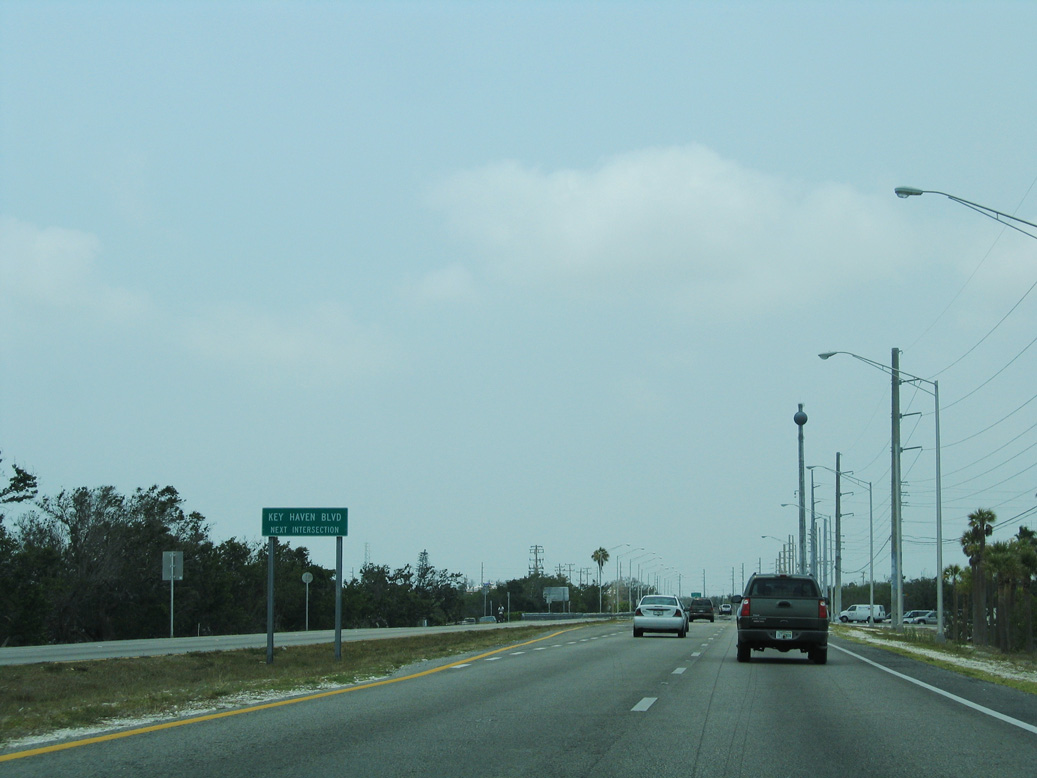
| Forthcoming Key Haven Boulevard spurs northward from U.S. 1 (Overseas Highway) to a network of canal-lined streets on Raccoon Key. 05/07/06 |
|
| 3rd Street stems south from U.S. 1 to an array of industrial businesses, apartments and manufactured homes on Stock Island. 10/17/20 |
|
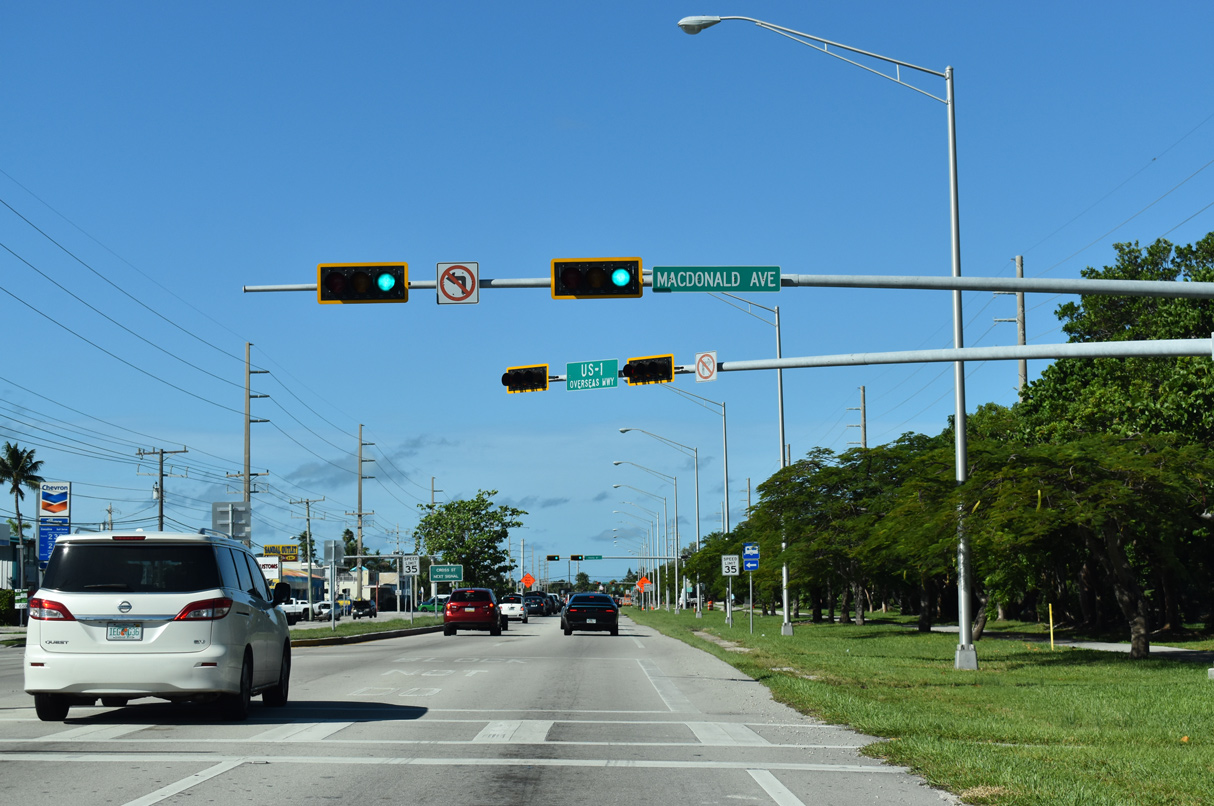
| The succeeding traffic light on U.S. 1 south is with Macdonald Avenue west of 5th Street. 5th Street leads south to Cow Key while MacDonald Avenue heads east to Maloney Avenue and southeastern reaches of Stock Island. 10/17/20 |
|
| Cross Street spurs 0.52 miles south from U.S. 1 to manufactured homes adjacent to Cow Key Channel. 10/16/20 |
|
| Reassurance marker preceding the western intersection with College Road on Stock Island. 10/17/20 |
|
| College Road loops 1.77 miles from U.S. 1 to the main campus of Florida Keys Community College on the north end of Stock Island. 10/16/20 |
|
| U.S. 1 (Overseas Highway) spans Cow Key Channel between Stock Island and Key West. 10/16/20 |
|
| Traffic partitions for SR A1A (S Roosevelt Boulevard) south and U.S. 1 (N Roosevelt Boulevard) south beyond Cow Key Channel. SR A1A loops through the southern reaches of Key West from Thompson Island to Key West International Airport (EYW) and Smathers Beach. 10/17/20 |
|
| The Overseas Highway ends at SR A1A and Roosevelt Boulevard. SR A1A meets Flagler Avenue a third of mile to the south. Passing through residential areas north of EYW Airport, CR 5A lines Flagler Avenue 2.51 miles west to White Street. SR A1A is sparsely signed along the 2.90 mile long course west to Bertha Street. 10/17/20 |
|
| U.S. 1 arcs northward along Roosevelt Boulevard to the commercial district of the city en route toward Downtown. 10/17/20 |
|
| U.S. 1 (Roosevelt Boulevard) runs along the Gulf of Mexico waterfront by Salt Pond Keys. 10/17/20 |
|
| A second HaWK signal operates along U.S. 1 (Roosevelt Boulevard) ahead of 17th Street. 10/17/20 |
|
| Southbound U.S. 1 reassurance marker posted west of Toppino Drive and ahead of the traffic light added for Searstown Shopping Center after 2011. 10/16/20 |
|
| Sigsbee Road extends north from U.S. 1 (N Roosevelt Boulevard) and Kennedy Drive along a causeway linking Key West with Dredgers Key and Naval Air Station Key West Dredgers Key-Sigsbee. 10/16/20 |
|
| A reassurance marker for U.S. 1 south stands along N Roosevelt Boulevard between Kennedy Drive and Key Plaza Shopping Center. 10/16/20 |
|
| U.S. 1 continues west along the commercial strip in Key West to Overseas Market shopping center. 10/16/20 |
|
| U.S. 1 crosses Salt Run Channel Bridge west beyond the signalized entrance to Overseas Market shopping center. 10/16/20 |
|
| Fifth Street / Macmillan Drive is an urban collector linking U.S. 1 (Roosevelt Boulevard) with parallel Flagler Avenue (CR 5A), 0.29 miles to the south near Key West High School. 10/16/20 |
|
| The U.S. 1 shield assembly preceding 5th Street before 2015 was relocated to a point beyond Macmillan Drive following reconstruction of Roosevelt Boulevard. 10/16/20 |
|
| 1st Avenue north and Palm Avenue south come together at the ensuing traffic light along U.S. 1 southbound. Palm Avenue angles northwest across Garrison Bight toward Naval Air Station Key West Trumbo Point Annex and the historic seaport district. 10/16/20 |
|
| N Roosevelt Boulevard advances west from Charterboat Row toward the Key West residential street grid. The shield for U.S. 1 posted after 1st Street was removed by 2019. 05/07/06 |
|
| Jose Marti Drive heads north from nearby Virginia Street and Bayview Park to become Eisenhower Drive north 0.27 miles to Palm Avenue. 10/16/20 |
|
| N Roosevelt boulevard becomes Truman Avenue along U.S. 1 west from Eisenhower Drive. 10/16/20 |
|
| White Street intersects U.S. 1 (Truman Avenue) at the next signalized intersection. White Street heads south to Higgs Beach, Rest Beach and Edward B. Knight Pier. 10/16/20 |
|
| U.S. 1 reassurance marker posted west of White Street at Pohalski Street north. 10/16/20 |
|
| Truman Avenue west between Grinnell and Packer Streets. 10/16/20 |
|
| Windsor Lane links U.S. 1 (Truman Avenue) with Amelia and Royal Streets to the south and Angela Street and Passover Lane by Key West Cemetery to the north. 10/16/20 |
|
| U.S. 1 (Truman Avenue) south at Simonton Street. Simonton Street crosses the length of Key West between Dog Beach and Key West Bight. 05/07/06 |
|
| A white guide sign precedes Duval Street along U.S. 1 (Truman Avenue) southbound. Duval Street is a major collector paralleling stretching 1.07 miles north from South Street near South Beach to Front Street and Downtown Key West. 05/07/06 |
|
| Duval Street north leads to Mallory Square and Pier. 05/07/06 |
|
| The final turn along southbound U.S. 1 takes the route north onto Whitehead Street from Truman Avenue west. Truman Avenue extends another three blocks to Naval Air Station Key West Truman Annex at Fort Street. 10/16/20 |
|
| The penultimate reassurance marker for U.S. 1 south stands just north of Truman Avenue on Whitehead Street. Tourists on bicycles, scooters, and small tourist shuttles frequent Whitehead Street north to the cruise piers. 10/16/20 |
|
| The last shield for southbound U.S. 1 stands along Whitehead Street north beyond Angela Street. 10/16/20 |
|
| Forthcoming Southward Street connects U.S. 1 with Fort Zachary Taylor Historic Park located at the west end of Key West. 10/16/20 |
|
| Southard Street heads three blocks west to a roundabout at Truman Waterfront Park and 0.70 miles east from U.S. 1 (Whitehead Street) to White Street at Naval Air Station Key West Peary Court. 10/16/20 |
|
| The Monroe County Courthouse lines the final block of U.S. 1 southbound on Whitehead Street. 10/16/20 |
|
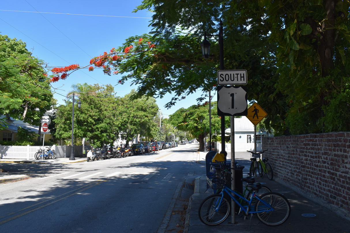
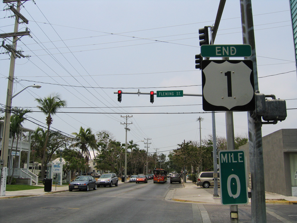
| Arguably the most photographed end sign of any highway. U.S. 1 concludes after a 2,376 mile long course through 14 states and the District of Columbia. A companion begin sign and milepost zero placard stand across Whitehead Street. 10/16/20 |
|
| Fleming Street leads east from the adjacent neighborhood 0.79 miles to to White Street. Whitehead Street continues north into Downtown Key West by Mallory Square and Pier. 10/16/20 |
|
| The previous end shield for U.S. 1 at Whitehead and Fleming Streets in Key West. 05/07/06 |
Page Updated 04-17-2024.