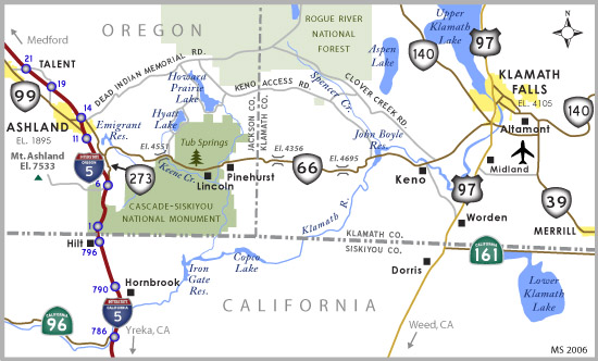
Connecting Ashland with Klamath Falls, Oregon 66 (Green Springs Highway) is one of the more interesting routes in the Beaver State. Originally forming the southernmost part of U.S. 97 prior to its realignment south to Weed, California in 19341, little has changed for the Green Springs Highway.
OR 66 commences its 59.05 mile run at OR 99 southeast of downtown Ashland, heading east to a diamond interchange with I-5. Turning southeast, OR 66 overlays the Green Springs Highway to OR 273 at the southern end of Emigrant Lake, where the route turns eastward for Keno and Klamath Falls. Following a windy and narrow shouldered road over the Cascade Mountain range, OR 66 passes over both Green Springs and Parker Mountains en route to Keno. At Keno, OR 66 turns northeast over a second crossing of the Klamath River to Fairhaven and the south end of Klamath Falls. The state highway concludes at a modified diamond interchange with U.S. 97 and OR 140.
Historically, OR 66 extended further east connecting Klamath Falls with Lakeview. When OR 140 was completed between Medford and Klamath Falls, the route was extended eastward over this portion of OR 66, truncating the state highway to U.S. 97. A 41 mile segment of OR 66 has been designated as a "historic highway" between Buckhorn Road near Emigrant Lake and the community of Keno.
Meeting OR 66 near Interstate 5 in the eastern limits of Ashland, Dead Indian Memoral Road crosses the Cascade Mountains, joining Green Springs Highway with OR 140 in Klamath County. Originally referred to as Dead Indian Road, controversy ensued in the early 1990s when some individuals objected to the road name and proposed to change it to Indian Memorial Road. While there was a push to change the name, others wanted to preserve it for heritage. To that end, a compromise was eventually reached, and Dead Indian Memorial Road was established.
|
| Westbound OR 66 commences from an interchange with OR 140-U.S. 97 in south Klamath Falls. U.S. 97 generally bypasses Klamath Falls to the west en route to Weed, California. 07/22/06 |
|
| OR 140 branches northwest from OR 66 to Odessa. The state highway joins Klamath Falls with Medford. 07/22/06 |
|
| Advancing southwest from OR 140 (Falls Highway), OR 66 travels nine miles to Keno and 61 miles to Ashland, where the state highway concludes. 07/22/06 |
|
| Passing through the Stewart Lenox district in southwest Klamath Falls. 07/22/06 |
|
| Leaving Klamath Falls, the Green Springs Highway travels through Klamath Basin farmlands and pastures. 07/22/06 |
|
| Located in northern California near Weed, Mount Shasta can be seen as far north as Klamath Falls in good weather conditions. 07/22/06 |
|
| Round Lake Road leads 3.7 miles northwest from OR 66 (Green Springs Highway) to the Round Lake Resort and Golf Course. 07/22/06 |
|
| Slow moving farm equipment is permitted to use the ensuing stretch of OR 66 to Keno. 07/22/06 |
|
| Several residence line this stretch of Green Springs Highway leading to the unincorporated community of Keno. 07/22/06 |
|
| Western junipers can be found throughout the foothills bordering OR 66, but give way to forests of ponderosa pine and fir as the Green Springs Highway trends west into the Cascade Mountains. 07/22/06 |
|
| Clover Creek Road branches northwest from OR 66 to Surveyor Mountain as it turns south to Keno. Clover Creek Road, in combination with Dead Indian Memorial Road, form an alternative to the Green Springs Highway to Ashland. 07/22/06 |
|
| Westbound OR 66 enters Keno beyond Clover Creek Road. 07/22/06 |
|
| OR 66 spans the Klamath River on the first of two crossings westward into the Cascade Mountains. The Klamath River Bridge was completed in March 1986 at a cost of $848,000, replacing a 1936-built span3. 07/22/06 |
|
| The river originates from Upper Klamath Lake near Klamath Falls, flowing southwestward 257 miles into northern California, emptying into the Pacific Ocean near Klamath. 07/22/06 |
|
| Keno-Worden Road angles south from OR 66 in Keno 7.6 miles to U.S. 97 in the community of Worden. 07/22/06 |
|
| The Green Springs Highway as it trends westward through the community of Keno. 07/22/06 |
|
| This distance sign along OR 66 westbound is posted ahead of Brennan Drive in Keno. 07/22/06 |
|
| Leaving Keno, OR 66 rises nearly 200 feet in elevation as the Green Springs Highway begins to cross the Cascade Mountain range. 07/22/06 |
|
| Turning once more at milepost 47, the Green Springs Highway beelines west, lowering toward the Klamath River at the John C. Boyle Reservoir. 07/22/06 |
|
| OR 66 west passes by Klamath Sportsmen's Park ahead of the Klamath River crossing. 07/22/06 |
|
| Previous scenes showing construction of the second Klamath River crossing along OR 66 westbound at John C. Boyle Reservoir. Work on the bridge included some realignment of the Green Springs Highway for improved geometry. The span was completed by the end of 2006. 07/22/06 |
|
| Former bridge spanning the Klamath River. 07/22/06 |
|
| Completed in 1958, the John C. Boyle hydroelectric dam is located 1.3 miles southwest of the Green Springs Highway. The dam is one of four slated for demolition by 2024 as part of a deal between Oregon and California to aid in restoring the Klamath River4. 07/22/06 |
|
| Keno Access Road ties into Green Springs Highway beyond the Klamath River crossing at John C. Boyle Reservoir. The local road angles 27.4 miles northwest around Surveyor Mountain to Dead Indian Memorial Road near Howard Prairie Lake in neighboring Jackson County. 07/22/06 |
|
| Ponderosa pines, Douglas-firs, and white firs comprise the bulk of east side Cascades forests here. Sugar pines, incense-cedars, and Western white pines are also seen. These views are near Hayden Mountain Pass, the first of three passes OR 66 will encounter. 07/22/06 |
|
| Westbound Green Springs Highway crosses its second pass at Parker Mountain. 07/22/06 |
|
| OR 66 travels west from Parker Mountain and crosses into Jackson County. 07/22/06 |
|
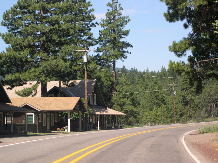
| OR 66 west at the community of Pinehurst. Permanently closed, the historic Pinehurst Inn was built from local timber during the 1920s, and became a prominent landmark along the Green Springs Highway. 07/22/06 |
|
| Entering Cascade-Siskiyou National Monument at Pinehurst, OR 66 continues west to Lincoln next. Managed by the Bureau of Land Management, the national monument was created in Summer 2000 and expanded in size by 2017. 07/22/06 |
|
| Entering the community of Lincoln beyond Corral Creek Road, OR 66 passes by Pinehurst School District 94. 07/22/06 |
|
| Lincoln is also home to The Oregon Extension, part of a group of St. Olaf College (Minnesota) off-campus study programs where students learn about sustainability and living intentionally. 07/22/06 |
|
| After departing Lincoln, highway 66 heads next to Tub Springs State Wayside, named after water tubs that were installed during the 1930s to provide spring water for travelers. The wayside is also an Applegate Trail Interpretive Site, with interpretive signs describing the wagon train led by Jesse Applegate that passed through the area in 1846.2 07/22/06 |
|
| A passing lane opens along westbound OR 66 beyond Tub Springs. 07/22/06 |
|
| A distance sign for Ashland stands in advance of E Hyatt Lake Road along Green Springs Highway west. 07/22/06 |
|
| OR 66 ends in 18 miles at OR 99 (Siskiyou Boulevard) in Ashland. E Hyatt Lake Road travels north to both Hyatt and Howard Prairie Lakes. 07/22/06 |
|
| Continuing west from E Hyatt Lake Road, OR 66 navigates hairpin turns at the Keene Creek Reservoir crossing. 07/22/06 |
|
| Westbound OR 66 reaches Green Springs Mountain Summit (elevation 4,551 feet). The Green Springs Highway descends nearly 2,600 feet to the floor of the Rogue Valley in the next 15 miles. 07/22/06 |
|
| A downhill grade begins following Green Springs Mountain Summit. 07/22/06 |
|
| Views of the Rogue Valley and Siskiyou Mountains beyond become visible along westbound OR 66 (Green Springs Highway). 07/22/06 |
|
| OR 66 west follows a narrow, windy course as it continues to lower to Rogue Valley and Ashland. This section of Green Springs Highway remains nearly identical to when originally constructed. 07/22/06 |
|
| In a few spots, the south shoulder is wide enough to allow motorists to pull over and take in panoramic views of the Rogue Valley and Siskiyou Mountains. 07/22/06 |
|
| Vegetation, most notably the trees, begins to change as the highway drops in elevation. Oregon white oaks become increasingly common. 07/22/06 |
|
| Mount Ashland (elevation 7,533 feet) and Interstate 5 come into view on the ensuing stretch of Green Springs Highway. Mount Ashland Ski Area is located near the summit. 07/22/06 |
|
| The landscape continues to change as OR 66 descends into the Rogue River Valley. 07/22/06 |
|
| Oregon white oaks are now the dominant tree species on these dry southwest-facing slopes. 07/22/06 |
|
| OR 66 (Green Springs Highway) west as it nears Rogue Valley. 07/22/06 |
|
| Green Springs Highway at Buckhorn Road. Buckhorn Road leads south to the Green Springs Power Plant. 07/22/06 |
|
| Old Green Springs Highway angles west from OR 66 ahead of Emigrant Creek. Portions of the original routing of OR 66 were submerged when nearby Emigrant Lake was created by damming Emigrant Creek. 07/22/06 |
|
| Prior to 1938, OR 66 ended Old Siskiyou Highway, which is the former alignment of U.S. 99 prior to its decommissioning. Though not signed, Old Siskiyou Highway is inventoried as OR 273. 07/22/06 |
|
| Turning north from Old Siskiyou Highway, OR 66 travels along the basin of Rogue Valley. Elevations within the valley typically range from 1,000 to 2,000 feet above sea level. The Rogue Valley is also typically dryer with an average annual rainfall between 20-30 inches. 07/22/06 |
|
| OR 66 west at the entrance to the Emigrant Lake Recreation Area. The Jackson County park is located at the north end of Emigrant Lake. 07/22/06 |
|
| Neil Creek Road and Corp Ranch Road come together at OR 66 west of the entrance road to Emigrant Lake Recreation Area. 07/22/06 |
|
| A confirming marker for OR 66 west is posted after Hidden Road. 07/22/06 |
|
| Westbound OR 66 meets Dead Indian Memorial Road at the eastern limits of Ashland south of Ashland Municipal Airport (AHM). Dead Indian Memorial Road travels a 36.3 mile course northeast into the Cascade Mountain range to OR 140 near Lake of the Woods. 07/22/06 |
|
| Within Ashland city limits, OR 66 (Ashland Street) angles west at E Main Street to Interstate 5. E Main Street joins OR 66 with downtown.
Ashland is home of the Oregon Shakespearean Festival. 07/22/06 |
|
| Ashland Street nears a diamond interchange with Interstate 5. 07/22/06 |
|
| Interstate 5 meets OR 66 (Ashland Street) 14 miles north of the California state line at the first of two interchanges for the city of Ashland. I-5 remains north of the city as the freeway continue northwest to Medford and Grants Pass. Traveling south, I-5 climbs to Siskiyou Summit ahead of entering California. 07/22/06 |
|
| Commercial development lines the remaining 1.2 miles of Ashland Street between I-5 and OR 99 (Siskiyou Boulevard). 07/22/06 |
|
| OR 66 (Ashland Street) meets Tolman Creek Road at the forthcoming traffic signal. Tolman Creek Road originates at E Main Street near I-5, extending south to OR 99 and Siskiyou Mountain Park. 07/22/06 |
|
| Ashland Street spans Clay Creek, a Central Oregon and Union Pacific railroad line, and the Central Ashland Bikepath near Faith Avenue. 07/22/06 |
|
| The signalized intersection with Walker Avenue precedes the conclusion of OR 66 (Ashland Street) at OR 99 (Siskiyou Boulevard). Walker Avenue serves as the only connection to OR 99 south. 07/22/06 |
|
| Westbound OR 66 (Ashland Street) ends at OR 99 (Siskiyou Boulevard) north opposite Southern Oregon University (SOU) campus. OR 99 follows Siskiyou Boulevard from OR 66 and SOU to downtown Ashland. The state highway parallels I-5 northwest to Talent and Phoenix before entering Medford. 07/22/06 |
Sources:
- Information on early U.S. 97 from Wikipedia, the Free Online Encyclopedia.
- Information from Oregon Parks and Recreation.
- Klamath River (Keno) Bridge, PCI Journal, March-April 1987 Edition, (www.pci.org).
- "Federal energy regulator gives final go-ahead for historic Klamath dam removal plan", Newsroom News Release, PacifiCorp (www.pacificorp.com).
07/22/06 by Matt Strieby
Connect with:
Interstate 5
U.S. 97
Page Updated 08-21-2006.