|
| Interstate H3 heads south from MCAS Kaneohe Bay along a causeway separating Kane'ohe Bay and Nu'upia Pond. The first confirming marker stands just beyond the freeway beginning. 02/05/24 |
|
| The Ko'olau Range rises to the west as Interstate H3 curves south between Kane'ohe Bay and Nu'upia Pond onto Mokapu Peninsula. 02/05/24 |
|
| A parclo B2 interchange (Exit 15) joins Interstate H3 with Kaneohe Bay Drive at the community of Mala'e. 02/05/24 |
|
| Kaneohe Bay Drive (Route 6511) straddles the bay southwest to Route 65 (Mokapu Saddle Road) at Mahinui and east to Kalaheo Avenue (Route 6012) and Kailua. The road was originally a part of Route 63 leading west from Kailua to Kaneohe. 02/05/24 |
|
| Interstate H3 is recognized as the John A. Burns Freeway. Burns (1909-1975) was the second Governor of Hawaii and a supporter for the construction of Interstate H-3. I-H3 was named in his honor by Governor Ben Cayetano in 1997.1 This sign was previously posted south of the entrance ramp from Exit 15. 01/17/11 |
|
| Affording motorists with views of Kane'ohe Bay and the surrounding peaks of the Ko'olau Range, the H-3 Lookout lines the westbound roadway adjacent to the Oneawa Hills. 02/05/24 |
|
| Continuing south from Mokapu Peninsula, Interstate H3 traverses the Oneawa Hills. 02/05/24 |
|
| An interchange sequence sign references Exit 11 to Kamehameha Highway and I-H201 at Pearl Harbor. 02/05/24 |
|
| This reassurance marker stands at a rock cut taking Interstate H3 west across the Oneawa Hills. 02/05/24 |
|
| A half diamond interchange joins Interstate H3 east with Route 65 (Mokapu Saddle Road). John A. Burns Freeway lowers from the Oneawa Hills by a quarry. 02/05/24 |
|
| Interstate H3 navigates through a series of S-curves northwestward on the gradual ascent to the Tetsuo Harano Tunnels across the Ko'olau Range. 02/05/24 |
|
| Route 83 (Kamehameha Highway) meets Interstate H3 at a parclo interchange (Exit 11) in 1.5 miles. 02/05/24 |
|
| Kamehameha Highway encircles most of Oahu from Route 61 (Kalanianaole Highway east / Pali Highway west) nearby to the North Shore, and Haleiwa as Route 83. Route 99 and Route 80 continue the loop south to Wahiawa, Pearl City, and Aiea. 02/05/24 |
|
| Exit 11 to Route 83 (Kamehameha Highway) is the last mainline exit from Interstate H3 westbound. John A. Burns Freeway ascends across the Ko'olau Mountains and lowers through North Halawa Valley into Pearl City. 02/05/24 |
|
| Route 83 (Kamehameha Highway) concludes 1.03 miles south of Exit 11 at Route 61 (Kalaniana'ole Hwy). Route 83 north connects with Route 65 (Kaneohe Bay Drive) east and Route 63 (Likelike Highway) south in Kaneohe. There is no direct access from I-H3 west to Likelike Highway. 02/05/24 |
|
| Pu'ukeahiakahoe and Pu'ukahuauli peaks in the Ko'olau Range rise prominently to the west of Interstate H3 and Kaneohe. 02/05/24 |
|
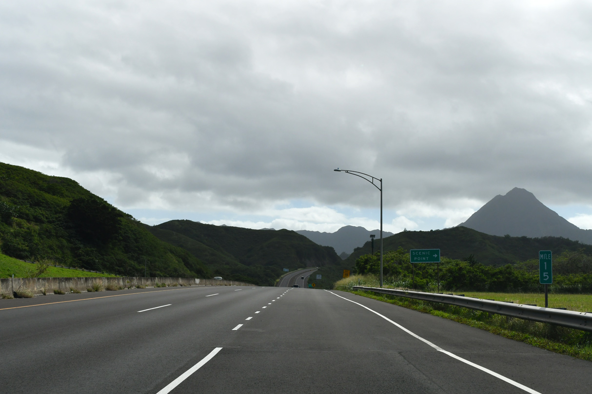
| 25,800 vehicles per day (vpd) were recorded by HDOT along I-H3 between milepost 8.56 and 10.5 in 2011. 02/05/24 |
|
| Encircling Ho'omaluhia Botanical Garden, I-H3 advances a half mile to the entrance ramp from Route 63 (Likelike Highway). The Wilson Tunnels along Route 63 cross the Koolau Range over 400 feet above this stretch of I-H3. 02/05/24 |
|
| Interstate H3 spans Luluku Stream and Route 63 on viaducts at the partial exchange (Exit 9) with Likelike Highway. 08/15/19 |
|
| Kane'ohe Bay, Po'uhawai'iloa Peak and Oneawa Hills spread into view to the northeast from Interstate H3 above Route 63 (Likelike Highway). 01/17/11 |
|
| A confirming marker stands beyond the entrance ramp from Route 63 (Likelike Highway) south. 02/05/24 |
|
| Encircling Pu'ukeahiakahoe mountain, Interstate H3 passes through Hospital Rock Tunnel at Kane'Ohe Forest Reserve. 08/15/19, 02/05/24 |
|
| The Windward Viaduct hugs the Pu'ukeahiakahoe hill side to the Tetsuo Harano Tunnels. The speed limit reduces to 45 miles per hour ahead of the tunnel. 02/05/24 |
|
| A crossover preceding the tunnels allows officials to close the westbound tube for maintenance or other situations. 01/17/11, 02/05/24 |
|
| A crossover ahead of the tunnels allows officials to close the westbound tube for maintenance or other situations. 02/05/24 |
|
| The westbound tube of the Tetsuo Harano Tunnel travels 4,980 feet through the Ko'olau Range.2 01/17/11 |
|
| The Tetsuo Harano Tunnel bears the name of a former state highways administrator who served office for 52 years and also as the H-3 Freeway administrator when the highway was completed in the 1990s.2 02/05/24 |
|
| The Tetsuo Harano Tunnel was constructed between 1990 and 1993. 02/05/24 |
|
| Emerging from the tunnel, Interstate H3 continues into North Halawa Valley along the 1.2 mile long North Halawa Viaduct. 02/05/24 |
|
| Interstate H3 drops over 500 feet in elevation on the 5.2 miles leading from the Tetsuo Harano Tunnels to the Halawa Interchange. 02/05/24 |
|
| North Halawa Stream parallels Interstate H3 through the scenic North Halawa Valley. The speed limit increases to 60 miles per hour along this stretch. 01/17/11 |
|
| A runaway truck ramp for I-H3 westbound precedes the built up areas of Halawa Heights. 02/05/24 |
|
| The viaduct system along Interstate H3 through North Halawa Valley extends nearly to the runaway truck ramp. 08/15/19 |
|
| Interstate H3 leaves North Halawa Valley southwest beyond the runaway truck ramp. 02/05/24 |
|
| Exit 1 C joins I-H3 with Ulune Street west to Kahuapaani Street (Route 7241) in a half mile. A loop ramp follows at Exit 1 B for Interstate H201 (Moanalua Freeway) east. 02/05/24 |
|
| Exit 1 C combines with Exit 1 E from IH-201 west before connecting with Ulune Street at Halawa Heights. Kahuapaani Street arcs 0.88 miles southwest from Ulune Street (Route 7239) to Salt Lake Boulevard near Aloha Stadium. 02/05/24 |
|
| Interstate H201 (Moanalua Freeway) continues east from the parclo interchange with I-H3 east to Fort Shafter and Honolulu. I-H201 provides a direct route for travelers between Pearl City and Honolulu as I-H1 loops to south to Honolulu International Airport (HNL). 02/05/24 |
|
| Route 7241 extends 1.44 miles north along Halawa Heights Road to Camp HM Smith. Ulune Street extends west to Aiea. 02/05/24 |
|
| Downtown Honolulu lies six miles east of Exit 1 B via I-H201 and I-H1. I-H3 parallels I-H201 and Halawa Stream west to the Halawa Interchange with Interstate H1 by Aloha Stadium. 02/05/24 |
|
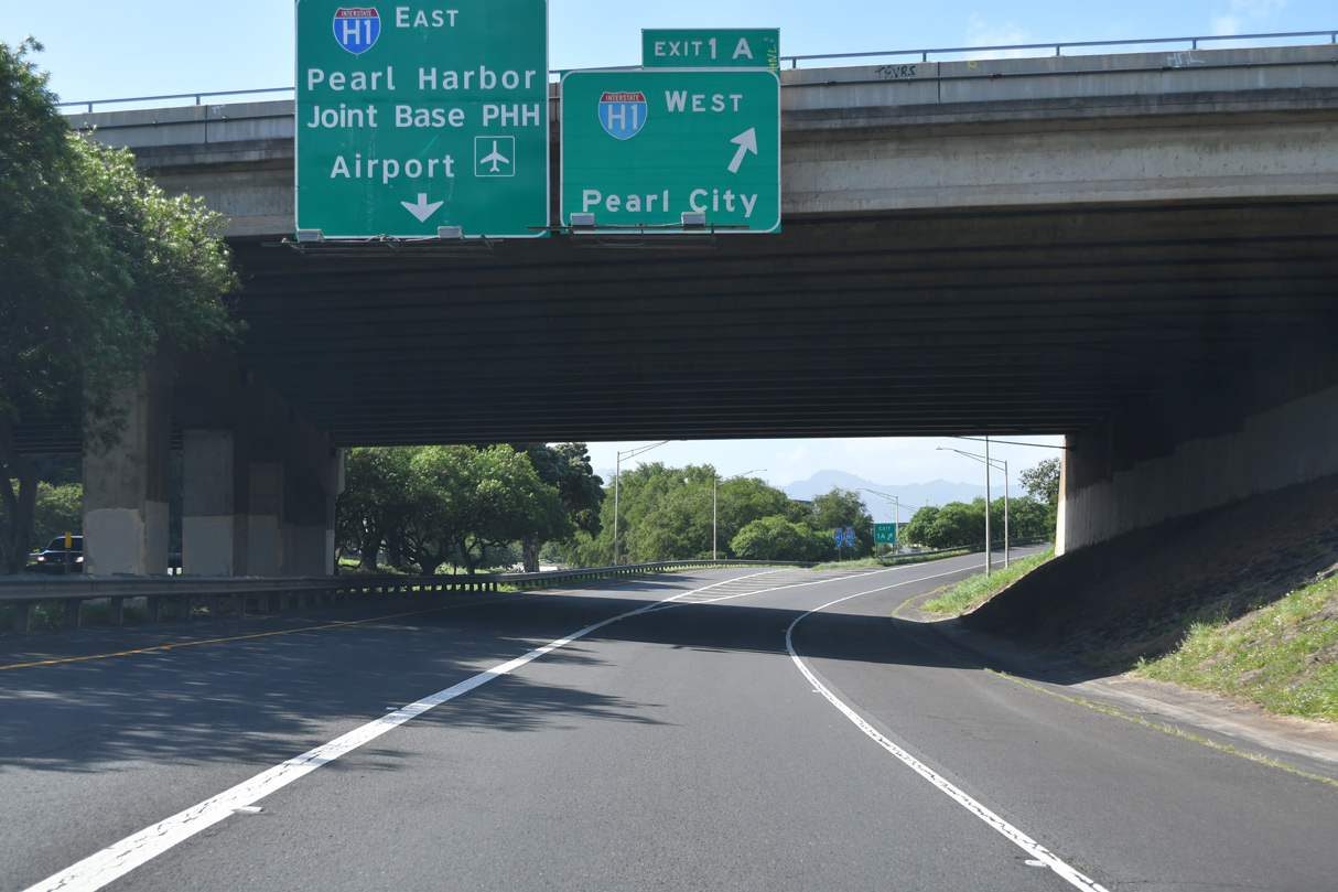
| Exit 1 A departs from I-H3 westbound for I-H1 west to Pearl City, Waipahu and Kapolei at the Kahuapaani Street (Route 7241) overpass. 02/05/24 |
|
| I-H1 advances south from the directional cloverleaf interchange with I-H3 to Route 92 (Nimitz Highway) and Joint Base Pearl Harbor-Hickam (PHH). 02/05/24 |
Page Updated 02-16-2024.

 West
West