|
| The three-wye interchange joining I-275/4 was originally built in 1965. The exchange was subsequently reconstructed between October 27, 2002 and December 22, 2006. Enhancements included the relocation of the flyover merge from I-275 south to I-4 east from the left to the right and the separation of the Jefferson Street and Ashley Drive ramps from the freeway mainline. 05/18/22 |
|
| Interstate 275 turns southwest from I-4 along northern reaches of the Tampa central business district. 04/26/24, 08/29/20 |
|
| Two lanes from the west end of I-4 dump traffic onto the Interstate 275 mainline by this reassurance marker. This stretch of freeway is often congested during the morning and evening peak hours. 03/04/16 |
|
| Continuing west beyond Downtown, I-275 advances to the West Riverfront and North Hyde Park neighborhoods. Exit 42 departs there for both Howard and Armenia Avenues.
A left side ramp was used during the multi-year widening of I-275 for Exit 42. It was switched to a right side exit in 2015. 04/25/16 |
|
| An entrance ramp joins Interstate 275 west from Ashley Drive north at the Hillsborough River and this shield. 04/26/24 |
|
| Exit 42 is a split diamond interchange joining I-275 with Armenia Avenue south and Howard Avenue north, a one way couplet joining the West Tampa and Hyde Park communities. 03/04/16 |
|
| A dynamic message board precedes a ramp stub at the Willow Avenue overpass along I-275 southbound. A companion stub lines the northbound side. 08/30/23 |
|
| Armenia Avenue stretches south from Carrollwood outside the city of Tampa to Swann Avenue at Palma Ceia Pines. A portion of this route was former Florida Secondary 587A. 05/18/22 |
|
| Two lanes separate from Interstate 275 south at Exit 42 to join parallel Green Street ahead of Howard Avenue north and Armenia Avenue south. Howard Avenue flows north from Bayshore Boulevard and Historic Hyde Park. 04/14/20 |
|
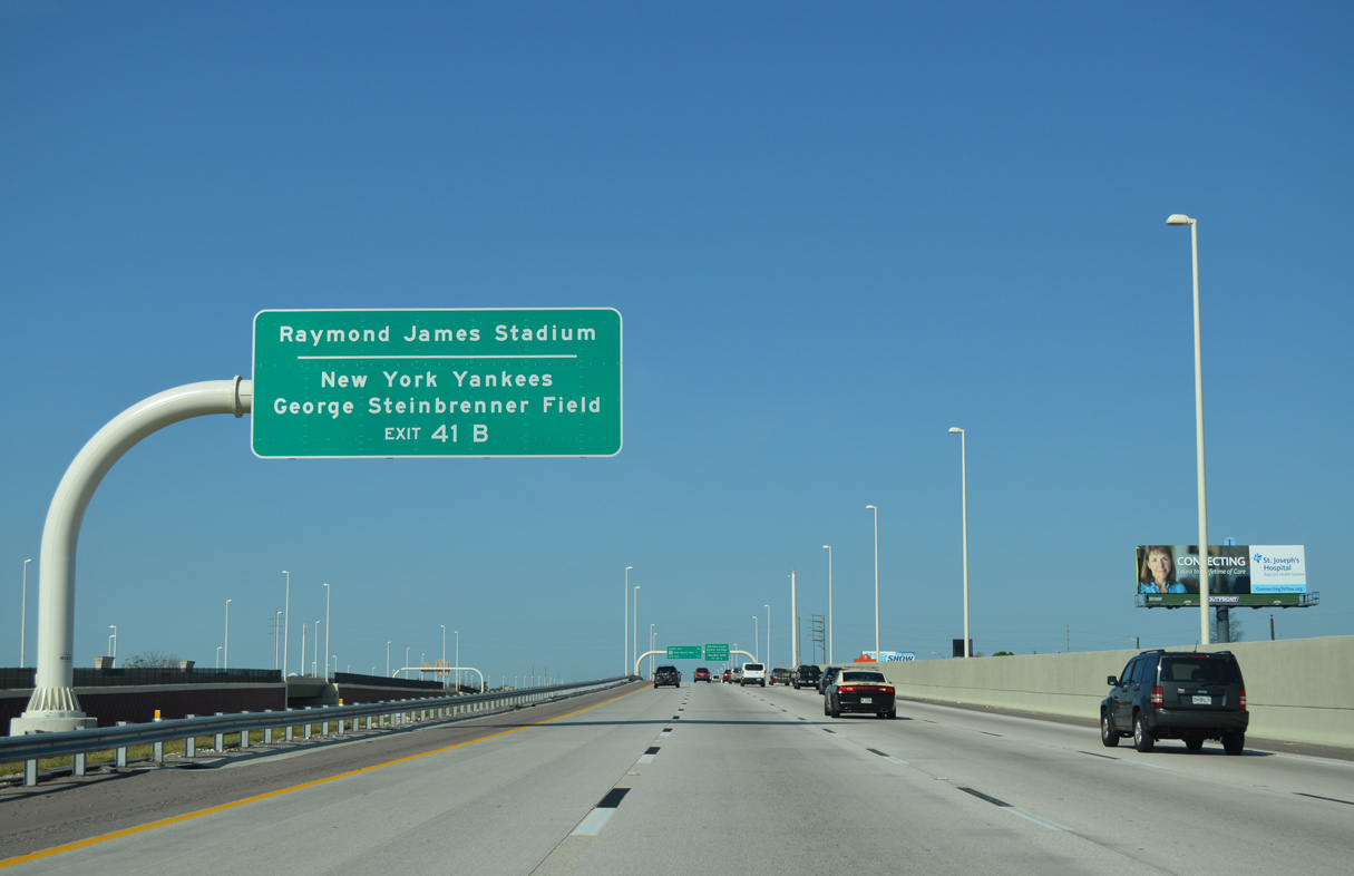
| Forthcoming Exit 41 B provides the most direct route from Interstate 275 to Raymond James Stadium and George Steinbrenner Field, Spring Training site for the New York Yankees. The venues line U.S. 92 (Dale Mabry Highway) north, 1.3 and 1.6 miles away from I-275 respectively. 03/04/16 |
|
| Proceeding through West Tampa, succeeding ramps for Himes Avenue at Exit 41 B and Dale Mabry Highway at Exit 41 A depart within the next mile. Dale Mabry Highway constitutes a crowded commuter route south to the gate for MacDill Air Force Base in South Tampa and north to Hillsborough Community College. 04/26/24 |
|
| A monotube supports a dynamic message board at the Green Street entrance ramp from adjacent Armenia Avenue. 04/25/16 |
|
| I-275 crosses over MacDill Avenue by MacFarlane Park just ahead of Exit 41. 04/14/20 |
|
| Himes Avenue parallels U.S. 92 (Dale Mabry Highway) northward through the adjacent MacFarlane Park neighborhood to the Stadium Area. Southward both roads continue to Oakford Park and Bon Air. 06/02/22 |
|
| Exit 41 B departs Interstate 275 south for Himes Avenue. This ramp was previously numbered Exit 41 C when two ramps served U.S. 92. 08/29/20 |
|
| U.S. 92 (Dale Mabry Highway) converges with Interstate 275 for the second time within Tampa at Exit 41 A. 06/02/22 |
|
| The north to south leg of U.S. 92 in Tampa follows Dale Mabry Highway from Hillsborough Avenue (SR 580) at Drew Park to Gandy Boulevard in South Tampa. 04/21/18 |
|
| U.S. 92 crosses the Gandy Bridge west over Tampa Bay to the Gateway area of St. Petersburg. 04/21/18 |
|
| Exit 40 B leaves I-275 south next for Cypress Street east of Lois Avenue. Lois Avenue leads north to International Plaza mall through the Carver City / Lincoln Gardens community. 06/02/22 |
|
| A modified diamond interchange joins Interstate 275 with Lois Avenue north of the North Bon Air neighborhood. Exit 40 A follows to West Shore Boulevard (CR 587) south through Westshore Palms and Beach Park.
A seven mile exit less stretch ensues beyond the Memorial Interchange (Exit 39) across the Howard Frankland Bridge. 06/02/22 |
|
| An entrance ramp joins I-275 south from Dale Mabry Highway a quarter mile ahead of the half diamond interchange (Exit 40 A) with West Shore Boulevard. 08/29/20 |
|
| WestShore Plaza mall lies on the south side of I-275 between West Shore Boulevard and the Memorial Interchange at SR 60. SR 60 branches northward from Kennedy Boulevard by the mall onto a freeway leading to Tampa International Airport (TPA) and Courtney Campbell Causeway ahead of Rocky Point. 06/02/22 |
|
| Exit 40 A parts ways with two lanes from Interstate 275 south to West Shore Boulevard. West Shore Boulevard doubles as unsigned CR 587 south from SR 616 (Spruce Street) at International Plaza mall to Interbay Boulevard at Port Tampa City. 06/02/22 |
|
| The West Shore Boulevard exit ramp passes over the Lois Avenue entrance ramp beside this shield assembly for I-275 south. This design eliminated a weaving traffic pattern between the closely spaced interchanges. 08/22/15 |
|
| SR 60 parallels Interstate 275 along Kennedy Boulevard, a heavily traveled commercial route, from Downtown Tampa to West Shore. The state road overtakes Memorial Highway northwest from Exit 39 toward TPA Airport, which replaced part of the original Memorial Highway to Dana Shores. 08/29/20 |
|
| Two lanes separate at Exit 39 for SR 60 west to SR 589 (Veterans Expressway) north. SR 60 (Courtney Campbell Causeway) crosses Old Tampa Bay en route to Clearwater. The cross peninsular route travels 161.34 miles from Vero Beach at Clearwater Beach. 06/02/22 |
|
| SR 589 (Veterans Expressway) stems north from SR 60 to Carrollwood, Citrus Park and Lutz among other Hillsborough County suburbs. The toll road extends along the Suncoast Parkway into Pasco County en route to U.S. 98 north of Brooksville and SR 44 near Crystal River. 04/26/24 |
|
| Underway from June 2019 to November 9, 2020, the I-275 Operational Improvements project added an additional through lane in both directions of I-275 between Lois Avenue and the Howard Frankland Bridge.1 Future road work upgrades the exchange with two Express Lanes per direction and a new flyover from I-275 north to SR 60 west.2 07/29/20 |
|
| I-275 angles southwest across Old Tampa Bay toward the Pinellas County peninsula. A distance sign once stood at this location referencing St. Petersburg and Largo. 04/26/24 |
|
| Doubling the capacity of the busy crossing between Tampa and St. Petersburg, the southbound Howard Frankland Bridge span opened with two-way traffic in August 1991. 08/20/22 |
|
| $865.3 million in work underway from Spring 2020 to late 2025 constructs a new bridge for Interstate 275 southbound and expands the overall Howard Frankland Bridge system with two Express toll lanes per direction.3 04/26/24 |
|
| The Howard Frankland Bridge southbound ascends across the navigational channel midway across Old Tampa Bay. 04/26/24 |
|
| Interstate 275 south enters Pinellas County across the Howard Frankland Bridge. The existing southbound span will be converted for use by northbound traffic after the adjacent eight lane bridge is completed.3 04/26/24 |
|
| Lowering from the apex of the Howard Frankland Bridge over Old Tampa Bay, I-275 travels 23.2 miles through Pinellas County. 04/26/24 |
|
| South from the Howard Frankland Bridge, Interstate 275 is formally St. Petersburg Parkway and William C. Kramer Highway. These designations overlay all of the freeway on peninsular Pinellas County. 03/04/16 |
|
| I-275 makes a gradual southwesterly turn into the city of St. Petersburg. Exit 32, the first of three wye interchanges, connects with SR 687 (4th Street N) south to U.S. 92 (Gandy Boulevard) at the Gateway area. 04/26/24 |
|
| 4th Street N stems south to Gandy Boulevard, where U.S. 92 turns southward alongside SR 687 through the 4th Street Business District to Downtown St. Petersburg. 04/26/24 |
|
| An assortment of arterial routes cross the width of Pinellas County to the Gulf of Mexico beaches. This include SR 688 (Ulmerton Road) west to Indian Rocks Beach, CR 296 (Bryan Dairy Road) west toward Indian Shores and CR 184 (38th Avenue N) to U.S. 19 Alternate for the Redington Beaches. 08/30/14 |
|
| Located further south along SR 699 (Gulf Boulevard), I-275 to 38th Avenue N leads to Madeira Beach followed by U.S. 19 ALT toward Treasure Island and SR 682 (Pinellas Bayway) west to St. Pete Beach. 08/30/14 |
|
| A 75 foot high decorative monument formerly welcomed visitors to St. Petersburg along I-275 south. Maintained by the city of St. Petersburg, the monument was erected by August 2012 at a cost of $600,000 from donated funds.4 The monument was removed due to construction of the new southbound span for the Howard Frankland Bridge. 08/30/14 |
|
| The first section of the tolled Interstate 275 Express Lanes runs south from ahead of SR 688 / Exit 31 to a point beyond SR 690 (Gateway Expressway) / Exit 30. 04/26/24 |
|
| SR 687 (4th Street N) measures 9.45 miles in length from the Howard Frankland Bridge approach to I-175 and SR 594 (5th Avenue S) south of Downtown St. Petersburg. 04/26/24 |
|
| SR 688 (Ulmerton Road) branches 1.5 miles west to combine with SR 686 beyond Feather South. Beyond the 1.03 mile long overlap, SR 686 (Roosevelt Boulevard) turns north to St. Petersburg-Clearwater International Airport (PIE). Both routes continnue west into the city of Largo. 08/30/14 |
|
| SR 688 (Ulmerton Road) travels 13.4 miles across Pinellas County from Exit 31 to SR 699/CR 183 (Gulf Boulevard) at Indian Rocks Beach. 04/26/24 |
|
| With one lane per direction, the tolled I-275 Express Lanes opened to traffic in Pinellas County on April 26, 2024. 04/26/24 |
|
| Dr. Martin Luther King Jr. Street N (9th Street N) comprises a four lane boulevard leading south between the Meadowlawn and Fossil Park neighborhoods to Historic Uptown in St. Petersburg. Shields for CR 803 appear along northern reaches of the route. 01/11/24 |
|
| Exit 31 partitions for ramps to SR 688 (Ulmerton Road) westbound for Largo, Pinellas Park and Indian Rocks Beach and to Martin Luther King Jr. Street (CR 803) south to St. Petersburg. 03/06/19 |
08/30/14, 08/22/15, 03/04/16, 04/25/16, 04/21/18, 03/06/19, 04/14/20, 07/29/20, 08/29/20, 05/18/22, 06/02/22, 08/20/22, 08/30/23, 01/11/24, 04/26/24 by AARoads
Page Updated 05-01-2024.

 South
South