Traveling south of I-80 between Exits 173 and 180, Business Loop I-80 (Winnemucca Boulevard) through Winnemucca links the freeway with Downtown, the Humbolt County Fairgrounds and an array of traveler services and retail. The route overlaps 1.6 miles northeast with U.S. 95 to Melarkey Street in the business district. SR 289 extends the route a half mile to East 2nd Street, where Business Loop I-80 turns southeast alongside SR 794. SR 794 spurs 2.44 miles east to Pedroli Avenue just north of Interstate 80.
|
| Business Loop I-80 (Winnemucca Boulevard) originates from a diamond interchange (Exit 173) with Interstate 80 southwest of Winnemucca. Designated also as FRHU20 (Humbolt County Frontage Road #20), the two lane road east from Exit 173 is former SR 289. 09/09/05 |
|
| Rose Creek Road (FRHU15) ties into Winnemucca Boulevard (old SR 289) from the southwest, linking with SR 796 to Winnemucca Municipal Airport (WMC). Rose Creek Road (historic U.S. 40) in conjunction with Airport Road represents the Airport Industrial Loop. 09/09/05 |
|
| A former milepost for SR 289 (HU 10,0) stood east of Rose Creek Road on Winnemucca Boulevard. 09/09/05 |
|
| SR 289 was truncated north from I-80 at Exit 173 to Downtown Winnemucca. The first shield was previously posted along Winnemucca Boulevard east after Bird Lane. 09/09/05 |
|
| Business Loop I-80 (Winnemucca Boulevard) crosses paths with Interstate 80 twice before entering the central business district. The business loop combines with U.S. 95 northbound from the freeway at Exit 176. 09/09/05 |
|
| A look at the shield assembly posted for the eastbound off-ramp from Exit 176 to Business Loop I-80 (Winnemucca Boulevard). 09/09/05 |
|
| Business Loop I-80/U.S. 95 confirming markers posted along Winnemucca Boulevard east ahead of the traffic light with Potato Road. The routes overlap for 1.4 miles to Melarky Street in Downtown. 09/09/05 |
|
| Business Loop I-80/U.S. 95 confirming markers posted along Winnemucca Boulevard east ahead of the traffic light with Potato Road The routes overlap for 1.4 miles to Melarky Street in Downtown. 09/09/05 |
|
| Potato Road comprises an east side service road to an array of businesses. It links with Fountain Way to the Winnemucca Sports Complex. 09/09/05 |
|
| A replacement of this shield assembly by Winnemucca Cemetery swapped out SR 289 for U.S. 95. 09/09/05 |
|
| Fourth Street eastbound splits from Winnemucca Boulevard ahead of the central business district. Fourth Street parallels Business Loop I-80 and U.S. 95 one block to the south to SR 794. 09/09/05 |
|
| Eastbound Business Loop I-80 (Winnemucca Boulevard) meets Hanson Street, which spans the Union Pacific Railroad tracks five blocks to the southeast. The street provides a through route between U.S. 95 and Highland Drive. 09/09/05 |
|
| Advancing into Downtown Winnemucca along Business Loop I-80/U.S. 95 east at Garrison Street. 09/09/05 |
|
| U.S. 95 northbound partitions from Business Loop I-80 (Winnemucca Boulevard) eastbound at Melarkey Street. The U.S. highway crosses Interstate 80 with no access to north reaches of the city at Pioneer Park. U.S. 95 forms part of the Winnemucca to the Sea Highway, which constitutes a long distance route to Boise, Idaho and Lakeview, Oregon via SR 140 and Oregon 140 west. 09/09/05 |
|
| Melarkey Street extends four blocks east from U.S. 95 as a local road to Railroad Street by the Winnemucca AMTRAK station. 09/09/05 |
|
| SR 289 commences a 1.627 mile route eastward from U.S. 95 (Melarkey Street). Bridge Street constitutes another north-south through route between Winnemucca Boulevard (old U.S. 40) and Highland Drive to the east. 09/09/05 |
|
| The commercial strip along Winnemucca Boulevard extends east from Downtown toward I-80. Pictured here is Business Loop I-80 at Reinhart Street. 09/09/05 |
|
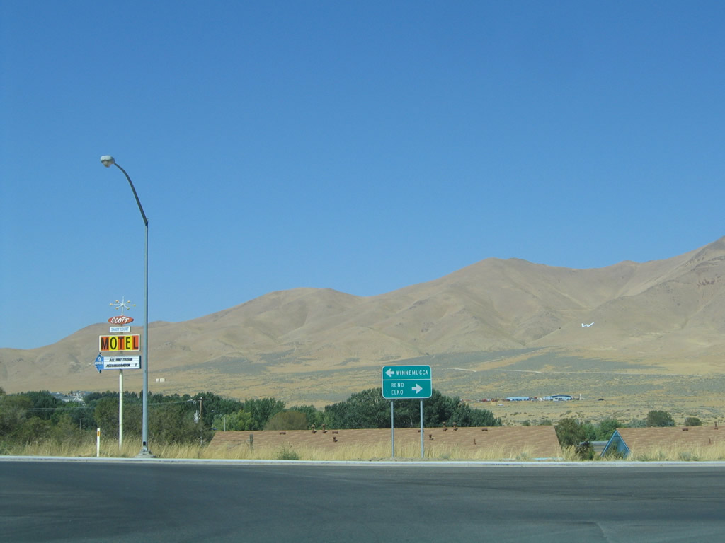
| Business Loop I-80 and SR 289 east part ways at Second Street. Business Loop I-80 (Winnemucca Boulevard) turns east alongside SR 794 for its remaining 2.2 miles. 09/09/05 |
|
| Second Street carries SR 289 east through a diamond interchange (Exit 178) with I-80 and SR 795 (Rhinehart Lane) for a link back to U.S. 95 north. 09/09/05 |
|
| I-80 meets SR 289 (2nd Street) at the third of four interchanges serving the Winnemucca area. 2nd Street extends beyond the state route end at SR 795 another two miles to the railroad siding of Weso. 09/09/05 |
|
| SR 794 arcs northwest from the diamond interchange at the east end of Business Loop I-80 to connect with Pedroli Lane north to Weso. Milepost HU 17.00 for SR 794 stands just north of I-80. 09/09/05 |
|
| SR 794 concludes its 2.439 mile route at the cattleguard 0.138 miles beyond the north side ramps of I-80 at Exit 180. 09/09/05 |
|
| SR 794 arcs south from agricultural areas along Pedroli Lane and immediately enters the diamond interchange (Exit 180) with I-80. 09/09/05 |
|
| The first confirming marker for SR 794 west precedes the north side ramps with Interstate 80. 09/09/05 |
|
| Business Loop I-80 accompanies SR 794 south from the I-80 westbound off-ramp along Winnemucca Boulevard. 09/09/05 |
|
| Interstate 80 ventures northeast from Winnmucca to circumvent the Sonoma Range at Button Point on the 123 mile drive to Elko. 09/09/05 |
|
| A sweeping S-curve takes Business Loop I-80/SR 794 (Winnemucca Boulevard) southwest to a commercial strip developed by 2014. The alignment severed the original path of U.S. 40. 09/09/05 |
|
| Advancing southwest, Business Loop I-80/SR 794 head toward the Humbolt County Fairgrounds and Winnemucca Municipal Park and Golf Course. 09/09/05 |
|
| Fairgrounds Road south and Haskell Street north come together at Winnemucca Boulevard between the fairgrounds and municipal golf course. Haskell Street south was previously the northern leg of SR 294. SR 294 begins one mile to the south at SR 787 (Hanson Street). 09/09/05 |
|
| Business Loop I-80 and SR 794 curve northwest and pass under the Union Pacific Railroad line via the Winnemucca Underpass. The structure was constructed in 1936 as part of the Victory Highway project for the original U.S. 40 route. 09/09/05 |
|
| Business Loop I-80 west shifts from SR 794 onto SR 289 along Winnemucca Boulevard into Downtown. 09/09/05 |
|
| A SR 794 end shield assembly is posted at the Business Loop I-80 westbound turn onto SR 289. Winnemucca Mountain (elevation 6,637 feet above sea level) rises north of the city. 09/09/05 |
|
| SR 289 spurs northeast along Second Street to the adjacent ramps with I-80 and SR 795 (Reinhart Lane) to U.S. 95. 09/09/05 |
|
| Business Loop I-80 and SR 289 proceed a half mile west to U.S. 95 (Melarky Street) in Downtown Winnemucca. The intersection with Melarky Street represents the east end of the Winnemucca-to-the-Sea highway. The auto trail links Winnemucca with Crescent City, California via U.S. 95, SR 140, Oregon 140, Oregon 62, former U.S. 99, and U.S. 199. U.S. 95 otherwise provides the most direct route from Winnemucca northward to Boise, Idaho and Lakeview, Oregon (via SR 140 west). 09/09/05 |
|
| U.S. 95 southbound joins Business Loop I-80 west along Winnemucca Boulevard from Downtown Winnemucca to Interstate 80 at Exit 176. U.S. 95 overlaps with the freeway west for 93 miles to Lovelock and the site of Trinity. 09/09/05 |
|
| West from U.S. 95, Winnemucca Boulevard continues along old U.S. 40 and intertwines with I-80 to Exit 173. Designated as FR20HU, Business Loop I-80 splits with the historic alignment of U.S. 40 at Rose Creek Road. Rose Creek Road and SR 796 (Airport Road) constitute the Airport Loop to Winnemucca Municipal Airport (WMC). 09/09/05 |
|
| Business Loop I-80 spurs west from Rose Creek Road to I-80 and a truck stop. 09/09/05 |
|
| Winnemucca Boulevard west meets the eastbound return ramp for I-80 to Winnemucca. 09/09/05 |
|
| Interstate 80 and U.S. 95 parallel the Humbolt River southwest 66 miles to Lovelock. Lovelock represents the next collection of services between Winnemucca and Fernley along I-80 and Fallon along U.S. 95. 09/09/05 |
|
| Little Table Top and Blue Mountains rise along the western horizon beyond the Business Loop I-80 return ramp to Interstate 80. 09/09/05 |
Page Updated 07-24-2018.

 East
East


 North
North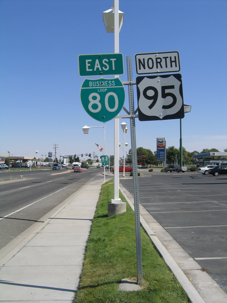


 East
East


 East
East