

 East
East
SR 143 (Hohokam Expressway) is a 4.06 mile long limited access highway running north from 48th Street and Exit 153 to McDowell Road.
03/01/19

SR 143 north leads back to Sky Harbor Airport (PHX). Exit 153 also connects with Broadway Road east into Tempe.
03/01/19

SR 143 (Hohokam Expressway) provides primary access to Sky Harbor International Airport (PHX) from points south. Former SR 153 paralleled SR 143 just to the west on what was the Sky Harbor Expressway.
03/01/19

I-10/U.S. 60 east enter the Broadway Curve 1.5 miles ahead of their separation at Exit 154.
03/01/19

A direct flyover connects the HOV lane along I-10 (Maricopa Freeway) east to the HOV lane along U.S. 60 (Superstition Freeway) east.
03/01/19

Continuing southward through the Broadway Curve along I-10/U.S. 60 eastbound. U.S. 60 along the Superstition Freeway joins Phoenix with Mesa and Gilbert. Beyond Apache Junction, U.S. 60 transitions into a divided highway en route to Florence Junction where SR 79 (former U.S. 89) ties in from the south
03/01/19

Prior to 1993, the Superstition Freeway was designated SR 360, and U.S. 60-89 followed Main Street through Mesa. With the completion of the freeway to Apache Junction, Main Street shifted to local control. U.S. 60 was realigned onto the Superstition Freeway when U.S. 89 was truncated north to Flagstaff.
03/01/19

U.S. 60 leaves I-10 (Maricopa Freeway) east with three lanes for the Superstition Freeway. The exchange at Exit 154 has been reconstructed numerous times, most recently in 2000.
03/01/19

Exit 155 leaves I-10 east for Baseline Road within the directional T interchange for U.S. 60. Baseline Road passes south of adjacent Arizona Mills mall and north of South Mountain Resort nearby.
03/01/19

Interstate 10 straddles the Guadalupe town line south of Baseline Road.
03/01/19

03/01/19

Elliot Road is a major arterial west into Ahwatukee and east through South Tempe.
06/19/07

03/01/19

Some of the last non-reflective button copy signs for Interstate 10 in Arizona were posted along this stretch.
06/19/07

Exit 158 departs Interstate 10 east for Warner Road. Warner Road is locally famous for IKEA, located just east of the Maricopa Freeway.
06/19/07
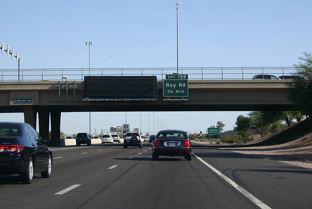
The diamond interchange at Exit 159 serves the retail corridor along Ray Road in both Ahwatukee and Chandler.
06/19/07

The auxiliary lanes between exits for Ray and Warner Roads were added in 2003.
06/19/07

Exit 159 departs for Ray Road.
06/19/07

Loop 202 returns to Interstate 10 along the Santan Freeway west and South Mountain Freeway east just beyond Exit 160 for Chandler Boulevard.
03/01/19

06/19/07

03/01/19

03/01/19

06/19/07

Flyovers directly connecting the I-10 HOV lanes with the Loop 202 (Santan Freeway) HOV lanes were constructed in 2010/11.
03/01/19

The four level interchange between the Santan Freeway (Loop 202) and Interstate 10 was constructed in 2003-04 and designed to accommodate the eventual South Mountain Freeway.
03/01/19

03/01/19

Prior to 2005, Exit 162 was a parclo interchange with Maricopa Road. Wild Horse Pass Boulevard east and Sundust Road were constructed in place of Maricopa Road along with a diamond interchange joining the two due to the growth of the Wild Horse Pass casino on the Gila River Indian Reservation.
05/31/21

Wild Horse Pass Boulevard links I-10 with Maricopa Road south to Wild Horse Pass Motorsports Park at Firebird Lake (set to close after a final NHRA event in 2023), Rawhide Western Town and the seasonal Santa's village.
05/31/21

SR 347 (Queen Creek Road) branches southwest from the succeeding exit along I-10 to the city of Maricopa.
05/31/21

05/31/21

Circumventing Casa Grande, SR 347, along with SR 84 west, provides a cutoff from I-10 east to Interstate 8 west toward Yuma and San Diego, California.
05/31/21

Maricopa lies midway between Exit 164 and SR 84 along the 28.67 mile long route of SR 347.
05/31/21

05/31/21

Queen Creek Road extends east from the diamond interchange at Exit 164 to the master-planned community of Ocotillo in the city of Chandler.
05/31/21

The Ak-Chin Indian Community lies southwest of Maricopa along Farrell Road.
05/31/21

05/31/21

Interstate 10 angles southeast to a diamond interchange (Exit 167) with Riggs Road.
03/01/19

Riggs Road leads east to the suburban community of Sun Lakes and west to SR 347.
03/01/19

01/17/05

Interstate 10 enters Pinal County. The seat is the town of Florence, located to the east along SR 79 (old U.S. 80/89) at SR 287.
01/17/05

Interstate 10 is known as the Pearl Harbor Memorial Highway through Arizona and New Mexico. East beyond the junction with I-8 near Casa Grande, I-10 is also part of the Border Friendship Route.
06/19/07

Interstate 10 converges with the south end of SR 587 at Exit 175 and Sweet Water Village in 1.25 miles.
06/19/07

SR 587 runs 6.10 miles north to SR 87 in Chandler. Casa Blanca Road ties into the parclo B2 interchange at Exit 175 from SR 587 to the west and Sacaton in the Gila River Indian Reservation to the southeast.
01/17/05

SR 587 is a remnant section of old State Route 93, which once ran northwest to Kingman and southeast to Nogales alongside U.S. 89.
06/19/07

The Sacaton Rest Area is next along Interstate 10 east in five miles.
06/19/07

Located north of Casa Grande, this rest area is the only one remaining on Interstate 10 between Phoenix and Tucson. A rest area near Picacho closed in the mid-1980s.
06/19/07

Photo Credits:
- 01/17/05 by AARoads.
- 06/19/07 by Kevin Trinkle.
- 03/01/19 by AARoads.
- 05/31/21 by AARoads.
Connect with:
U.S. 60
State Route 347
Page Updated 04-08-2022.