|
| SR 7 upgrades to a freeway south of AAA Boulevard to SR 1. A diagrammatic overhead outlines the lane drop for Exit 166 to SR 58 (Churchmans Road) and the collector distributor roadway (Exits 165A/B) for I-95. 12/25/20 |
|
| Two lanes depart SR 7 south for Exit 166 to SR 58. SR 58 (Churchmans Road) travels 3.86 miles from SR 4 near Christiana Hospital and Delaware Park east to SR 273 near Hares Corner. 12/23/22 |
|
| Traffic to I-95 continues through the intersection with SR 58 (Churchmans Road) onto the c/d roadway for Exits 165A/B. A direct ramp joining SR 7 south to I-95 was planned but never built. 12/23/22 |
|
| Beyond the traffic light at SR 58 (Churchmans Road), drivers ascend onto the c/d roadway to I-95 and SR 1/7 south. I-95 leads south from Exit 165A to SR 273 and SR 896 south of Newark. 12/22/18 |
|
| Two lanes continue along the c/d roadway south to I-95 north (Exit 165B) and SR 1 south to Dover. 12/22/18 |
|
| Interstate 95 generally travels west from Newark to Baltimore, Maryland along John F. Kennedy Memorial Highway. A toll collection point precedes the state line. 12/22/18 |
|
| Suffixes are counter intuitive for Exit 165 and 164 along SR 1 south as B follows A. I-295 north branches east from I-95 north to the Delaware Memorial Bridge 2.5 miles from Exit 165 B. I-95 continues from there to Wilmington and Philadelphia. 12/23/22 |
|
| Construction between July 2011 and late 2014 upgraded the cloverleaf interchange between SR 1 and I-95 with flyovers. The high speed ramps eliminated two of the four loop ramps and associated weaving traffic patterns. 08/17/21, 09/27/14 |
|
| Succeeding loop ramps depart SR 1 south at Exit 164A for Mall Road to Christiana Mall and Exit 164B for the continuation of SR 7 south onto adjacent Stanton Christiana Road. A two lane flyover from I-95 south combines with the single lane of SR 1 south from SR 7. 12/25/20 |
|
| The first reassurance marker for SR 1 south precedes the Mall Road overpass. A compact trumpet interchange was built here in 1979/80 to accommodate the newly built Christiana Mall. 08/17/21 |
|
| Traffic from Interstate 95 south appears as Exit 164 A leaves SR 1/7 south. Mall Road encircles Christiana Mall while SR 7 splits with SR 1 for Road A and Christiana. 12/23/22 |
|
| A concrete barrier separates traffic from the I-95 flyover and the mainline of SR 1 south through the folded diamond interchange (Exit 164 B) with SR 7 (Road A). SR 7 parallels SR 1 southward from Christiana to Bear, Red Lion and SR 72 at Wrangle Hill. 12/23/22 |
|
| Forthcoming SR 273 is a principal arterial running from the city of Newark to Hares Corner and New Castle. SR 273 was expanded to four lanes east of SR 1 in 1994 and realigned onto a controlled access arterial west of Ogletown in 1997. 12/23/22 |
|
| SR 1 south expands to three lanes ahead of the diamond interchange (Exit 162) with SR 273. Completed in 1993, the segment of SR 1 between SR 7 and SR 273 crosses an area of wetlands and the Christina River. 12/30/16 |
|
| SR 273 forms a multi state route with MD 273 between U.S. 1 at Harrisville, Maryland and SR 9/141 in New Castle. SR 273 takes a bypass built in 1987 around the south and west side of Christiana nearby. 12/23/22 |
|
| Exit 162 lowers from SR 1 south to meet SR 273 (Christiana Road) adjacent to SR 7 (E Main Street). Routine congestion occurs here and departs and lowers to intersect SR 273 (Christiana Bypass) just east of SR 7 (E Main Street). |
| Heavy commuter traffic to Bear utilizes SR 273 west to SR 7 south during afternoon and evening peak hours. 06/26/10 |
|
|
| SR 1 advances one mile south to the parclo interchange (Exit 160) with U.S. 40 (Pulaski Highway) at Bear. Construction from March 20, 2020 to November 2020 added an auxiliary lane from SR 273 to Exit 160. 12/23/22 |
|
| Guide signs for Exit 160 were changed in 2013 to reference Bear and Glasgow in place of State Road, where U.S. 40 east merges with U.S. 13 north, and Elkton, Maryland. Bear is the unincorporated area centered around U.S. 40/SR 7 while Glasgow lies to the west at SR 896. 12/23/22 |
|
| SR 1 south reaches Exit 160 to U.S. 40 (Pulaski Highway). Pulaski Highway constitutes a slow moving arterial from Bear west to Elkton, Maryland. Suburban development in the 1990s and 2000s engulfed the previously rural corridor with apartment complexes, retail, and numerous housing tracts. 12/21/22 |
|
| A two lane ramp (Exit 160) connects with Pulaski Highway from SR 1 south. 12/18/16 |
|
| The left turn for U.S. 40 (Pulaski Highway) east toward State Road doubles as the connection for adjacent Eden Square Shopping Center, located at the southwest corner of U.S. 40 and SR 7. 12/18/16 |
|
| The upcoming trumpet interchange (Exit 156) with U.S. 13 (Dupont Highway) was expanded with a ramp to SR 71 (Red Lion Road) in Spring 1998. 12/21/22 |
|
| Springfields Boulevard (Rd 381) and a Norfolk Southern Railroad line pass under SR 1 beyond this shield assembly. The ensuing stretch passes between the Bear Crossing and Springfields subdivisions. 12/21/22 |
|
| The Delaware City oil refineries appear along the southern horizon ahead of Left Exit 156 for U.S. 13 (Dupont Highway) north and SR 71 (Red Lion Road) south. The initial segment of SR 1 opened to traffic from SR 273 near Christiana and U.S. 13 (Dupont Highway) at Tybouts Corner in 1991. 12/23/22 |
|
| SR 1 southbound reduces to a single lane beyond Left Exit 156 for U.S. 13 (Dupont Highway) north to State Road and SR 71 south to Red Lion. The ensuing stretch of SR 1 was completed in 1995. 12/23/22 |
|
| Exit 156 A partitions with Exit 156 B for SR 71 (Red Lion Road) south. SR 71 comprises a 21.99 mile long loop west from U.S. 13 (Dupont Highway) through Red Lion, Summit Bridge and Middletown and U.S. 13 south of Townsend. 12/23/22 |
|
| A study to widen SR 1 south to U.S. 13 (Dupont Highway) includes an alternative for the slight realignment of the exit ramp to SR 71 south, and a new ramp from SR 71 north to U.S. 13 north. This will eliminate the at-grade intersection between the two routes. 12/23/22 |
|
| U.S. 13 and SR 1 overlap for 2.18 miles east of Red Lion and west of the Delaware City refinery complex. 12/21/22 |
|
| Crossing Red Lion Creek, which flows east directly to Hamburg Cove on the Delaware River. 12/21/22 |
|
| A 0.50 mile segment of old U.S. 13 (S Dupont Highway) was repurposed as a service road along the west side of U.S. 13/SR 1 near Red Lion. 12/25/20 |
|
| U.S. 13 parts ways with SR 1 in one mile to join SR 72 (Wrangle Hill Road) east 0.25 miles to Dupont Highway. Dupont Highway runs south to St. Georges. 12/21/22 |
|
| SR 72 forms a 17.36 mile long route from SR 9 east of Wrangle Hill to SR 7 in the Pike Creek Valley. Locally SR 72 joins Delaware City with Glasgow and Newark. 12/25/20 |
|
| Entering the diverging diamond interchange (Exit 152) with U.S. 13 south and SR 72 (Wrangle Hill Road) on SR 1 south. U.S. 13 Bypass, signed from 1995 to 1998, overlapped with SR 1 south from Exit 152 to South St. Georges. 12/21/22 |
|
| Improving safety and traffic flow, construction from Spring 2016 to January 2017 reconfigured the diamond interchange joining U.S. 13/SR 1 with SR 72 into a DDI. 08/17/21 |
|
| SR 1 continues with six lanes to the Chesapeake and Delaware Canal. 12/30/18 |
|
| A distance sign posted eight miles north of Odessa and 31 miles from Dover precedes the SR 1 crossing of Dragon Creek. 12/21/22 |
|
| One of the U.S. Army Corps of Engineers requirements for maintaining the Chesapeake & Delaware Canal Bridge on SR 1 was that the crossing remain toll free. As a result, Exit 148 to U.S. 13 at South St. Georges was constructed in 1999. 12/21/22 |
|
| Travelers remaining along SR 1 south of the Canal Bridge reach the Biddles Corner main line toll plaza in two miles. A dynamic toll schedule sign displays the variation in rates from weekdays to weekends. 12/21/22 |
|
| The SR 1 span across the Chesapeake & Delaware Canal was designated the U.S. Senator William V. Roth, Jr. Bridge by the Delaware Legislature in 2007. 12/25/20, 12/21/22 |
|
| The SR 1 cable-stayed bridge is similar in design to the Varina-Enon Bridge carrying I-295 across the James River Bridge in Virginia, and the Sunshine Skyway Bridge (I-275/U.S. 19) in Florida. The signature span features gold cables, representative of one of the state colors. 12/28/16 |
|
| The Roth Bridge measures 4,498 feet in length at a height of 145 feet above the C & D Canal.1 The ten foot wide shoulders can be restriped to expand each roadway to four lanes. 06/18/12 |
|
| Original lighting fixtures on the SR 1 bridge illuminated both the roadway and the cables so that they were visible from as far north as Tybouts Corner. Unfortunately the illumination caused issues with mariners below and during a 2005 snowstorm, a plow left in the upright position knocked over several light poles. 12/28/16 |
|
| Passing by the south tower of the Roth Bridge along SR 1 southbound. Taking three years to build, the span opened to traffic on December 23, 1995. 06/18/12 |
|
| Exit 148 lowers to Lorewood Grove Road (Rd 412) east of the Town of Whitehall development. A wye interchange (Exit 147) with U.S. 301 (First Responders Memorial Highway) southwest to Middletown follows. 12/21/22 |
|
| Lorewood Grove Road parallels the C & D Canal between Summit Bridge and U.S. 13 at South St. Georges. 12/28/16 |
|
| The Biddles Corner Toll Plaza lies 0.75 miles south of Exit 148 and South St. Georges. 12/21/22 |
|
| U.S. 301 along the First Responders Memorial Highway opened to traffic on January 10, 2019. The toll road extends 11 miles southwest to the Maryland state line between Middletown and Warwick. 12/21/22 |
|
| U.S. 301 was relocated off of SR 896 from Glasgow and Summit Bridge onto the First Responders Memorial Highway toll road. Traveling around 1,100 miles to Sarasota, Florida, U.S. 301 joins the Wilmington area with Annapolis, Maryland. 12/21/22 |
|
| The Biddles Corner Toll Plaza along SR 1 was the first in Delaware to include high speed E-ZPass lanes. 12/21/22 |
|
| The cash lanes expand to five booths in each direction along the outside of the Biddles Corner plaza. 12/21/22 |
|
| A set of transponder readers collect tolls above the E-ZPass lanes while drivers maintain highway speed. 12/21/22 |
|
| SR 1 reduces from six to four overall lanes between the toll plaza and diamond interchange (Exit 142) with Pole Bridge Road at Boyds Corner. Pole Bridge Road extends east from U.S. 13/SR 896 to Port Penn Road. 12/21/22 |
|
| SR 1 passes over U.S. 13 (Dupont Highway) ahead of Exit 142 with Pole Bridge Road. Pole Bridge Road leads west to become SR 896 (Boyds Corner Road) north at adjacent U.S. 13. SR 896 runs west along Boyds Corner Road to Mount Pleasant and an overlap with SR 71 north to Summit Bridge and Glasgow. 12/21/22 |
|
| A small guide sign references the toll road along SR 1 by its official name, the Korean War Veterans Memorial Highway. Similar signs are posted elsewhere along the expressway. 08/05/07 |
|
| Exit 142 leaves SR 1 south for Pole Bridge Road (Rd 420) to Port Penn and SR 896 (Boyds Corner Road). The Bayberry suburban community takes shape along Boyds Corner Road between U.S. 13 and SR 71. 12/21/22 |
|
| Bayview Road (Road 423) spans SR 1 by this reassurance marker while en route east from U.S. 13 (Dupont Highway) to SR 9. This shield assembly was removed by 2019. 06/18/12 |
|
| SR 1 runs between U.S. 13 (Dupont Highway) and Vance Neck Road by this distance sign posted 25 miles north of Dover. A greenout by Odessa revised the mileage from four to two. 12/21/22 |
|
| SR 1 again shifts west of U.S. 13 beyond Drawyer Creek to circumvent the town of Odessa. 12/21/22 |
|
| Adjacent to suburban Middletown is a diamond interchange (Exit 136) connecting SR 1 with SR 299 (Middletown Odessa Road). Exit 136 serves interests to Townsend, an incorporated town along SR 71 south of Middletown, by way of U.S. 13 to Pine Tree Road (Road 25). 12/21/22 |
|
| SR 299 travels northwest from SR 9 (Taylors Bridge Road) into Odessa along Main Street then west to SR 1. Beyond Exit 136, the SR 299 travels 2.25 miles to SR 71 (Broad Street) in Downtown Middletown. 12/21/22 |
|
| There are no tolls charged at Exit 136 for SR 299 (Main Street / Middletown-Odessa Road). A previously rural route, SR 299 constitutes a suburban corridor between Odessa and Middletown. 12/21/22 |
|
| The longest uninterrupted stretch of the SR 1 toll road ensues south from Odessa to Exit 119 north of Smyrna. Opened to traffic May 20, 2003, this 17 mile long section of SR 1 was the last to be completed. This confirming marker was taken down by 2017. 06/18/12 |
|
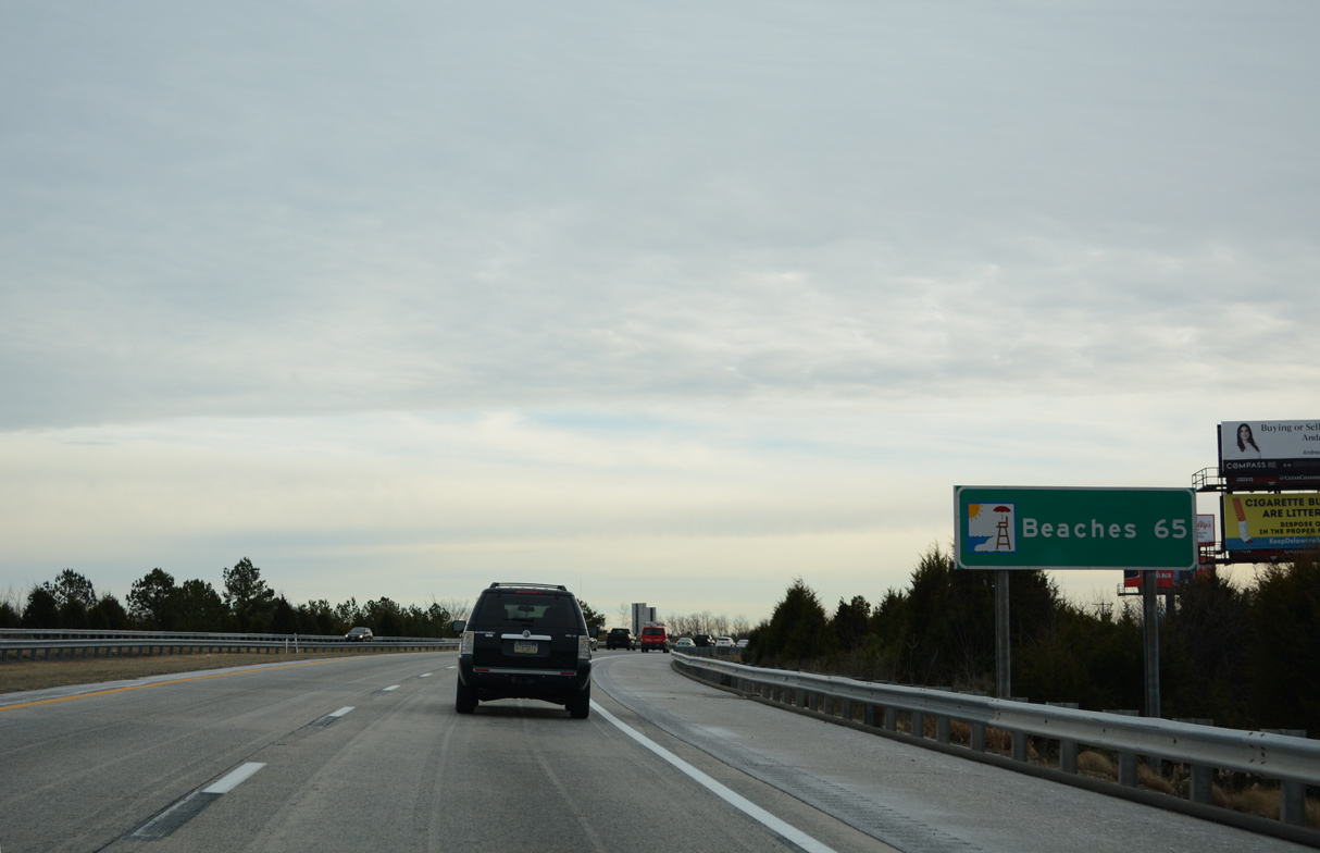
| A distance sign preceding the Appoquinimink River along SR 1 south references Beaches in 65 miles, where SR 1 meets SR 1A (Rehoboth Avenue) south into Rehoboth Beach. 12/26/22 |
|
| SR 1 remains west of U.S. 13 between Odessa and a point south of Pine Tree Corners. The two intertwine by the intersection joining U.S. 13 (Dupont Highway) with SR 71 (Summit Bridge Road) near Blackbird. 12/21/22 |
|
| Considered until at least February 2004, an interchange with SR 71 was originally planned along this stretch of SR 1. 12/21/22 |
|
| A reassurance marker for SR 1 appears south of Blackbird Creek and after the location of the unconstructed interchange with SR 71. 12/21/22, 12/26/22 |
|
| Crossing over U.S. 13 (Dupont Highway) near Blackbird, three miles north of Smyrna and 14 miles out from Dover on SR 1 south. 12/21/22 |
|
| One mile north of the parclo interchange (Exit 119) with U.S. 13 (Dupont Highway) on SR 1 south. Trailblazers for SR 6/300 are signed for U.S. 13 south into Smyrna. 12/26/22 |
|
| Exit 119 A departs in one half mile for U.S. 13 (DuPont Parkway) south into Smyrna. SR 6 travels across Smyrna, linking the municipality with Woodland Beach along Delaware Bay to the east and Clayton to the west. A multi state route, SR 300 angles southwest from Smyrna-Clayton to Kenton and Sudlersville, Maryland. 12/21/22 |
|
| Exit 119 connects the toll road with the adjacent Delaware Welcome Center and rest area on U.S. 13. 12/26/22 |
|
| U.S. 13 (Dupont Highway) again passes under SR 1 at Exit 119. Smyrna, a suburban town of over 13,000, lies just south of the Kent County line along U.S. 13. 12/26/22 |
|
| The guide sign at Exit 119 B omits Townsend for U.S. 13 north. The ramp ties into U.S. 13 opposite Duck Creek Road (Road 486) and just north of the Smyrna rest area. 12/26/22 |
08/05/07, 06/26/10, 06/18/12, 09/27/14, 12/18/16, 12/28/16, 12/30/16, 12/22/18, 12/30/18, 12/25/20, 08/17/21, 12/21/22, 12/23/22, 12/26/22 by AARoads
Page Updated 01-07-2023.


 South
South