This page showcases extant segments of Historic U.S. 80 west and Historic U.S. 395 south in San Diego along Park Boulevard and Market Street.
| Historic U.S. 80 west & Historic U.S. 395 south |
|
U.S. 80 and U.S. 395 proceed south on Park Boulevard. Initially, Park Boulevard serves as a boundary between North Park/University Heights on the east and Hillcrest on the west. A small business area lines Park Boulevard between El Cajon Boulevard and Robinson Avenue. Photo taken 06/05/11. |
|
By 2012, a trailblazer marker for Historic U.S. 395 was added on southbound Park Boulevard on a centerline light pole between Howard Avenue and Polk Avenue. A similar sign was placed along northbound between Howard Avenue and El Cajon Boulevard. Photo taken 05/07/12. |
|
Southbound Park Boulevard meets Polk Avenue at this traffic signal. After the traffic signal, turn right for Centre Street. Photo taken 06/05/11. |
|
U.S. 80 and U.S. 395/Park Boulevard approaches Lincoln Avenue (four-way stop). Changes are planned for this segment of Park Boulevard as a result of a proposed bus rapid transit corridor along Park Boulevard and El Cajon Boulevard. Photo taken 06/05/11. |
|
A landscaped median separates the two directions of traffic on this wide section of Park Boulevard. Photo taken 06/05/11. |
|
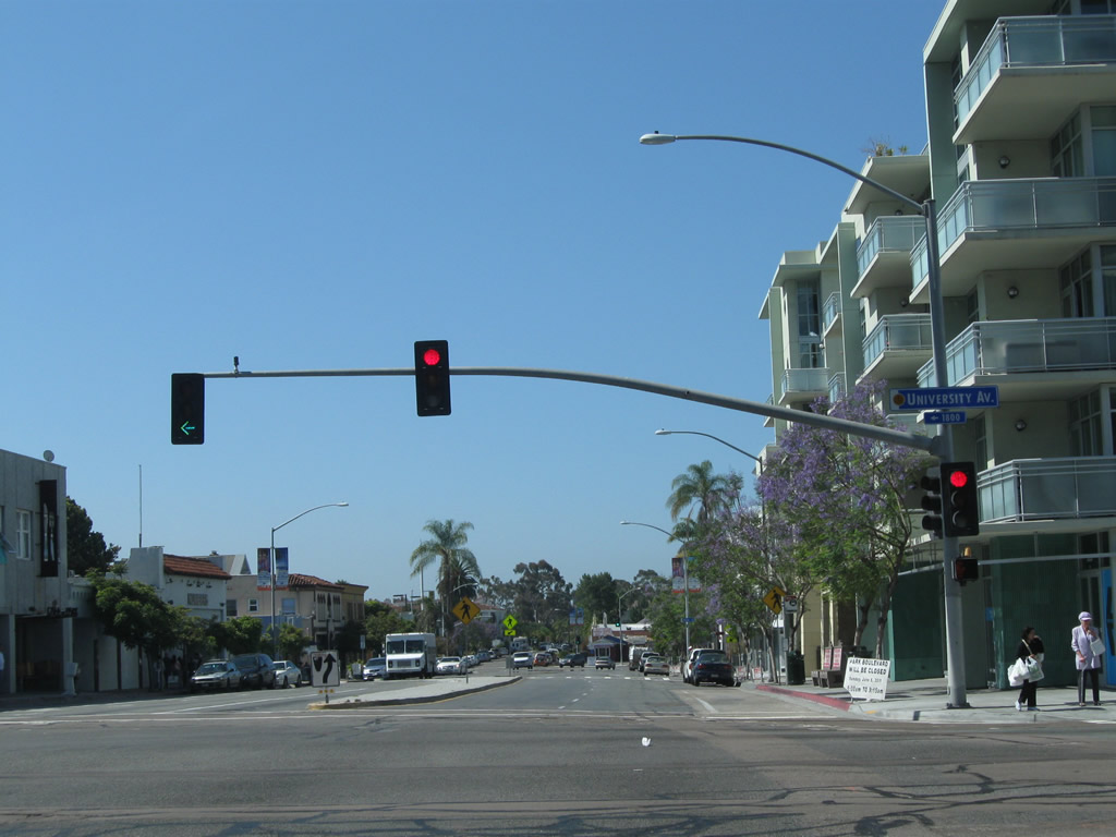
Southbound Park Boulevard meets University Avenue. For a time around 1926, U.S. 80 was routed along University Avenue rather than El Cajon Boulevard and Park Boulevard. Turn left for University Avenue east to North Park and City Heights. Turn right to Hillcrest and Mission Hills. Photo taken 06/05/11. |
|
Park Boulevard curves toward the southwest at Essex Street. Photo taken 06/05/11. |
|
Southbound Park Boulevard meets Robinson Avenue as it continues to curve toward the southwest. Indiana Street leads due south from this intersection. Photo taken 06/05/11. |
|
|
Park Boulevard again curves south at this intersection with Pennsylvania Avenue, then intersects Cypress Avenue, Brookes Avenue, Myrtle Avenue, and Upas Street before entering Balboa Park. Photos taken 06/05/11. |
|
|
|
The first intersection in Balboa Park along Park Boulevard south is with Zoo Drive and Morley Field Drive. Photo taken 06/05/11. |
|
A turfed (grass) landscape median separates the two directions of traffic along Park Boulevard. Photo taken 06/05/11. |
|
Turn right on Zoo Place to the World Famous San Diego Zoo. Park Boulevard continues south through Balboa Park. Photo taken 06/05/11. |
|
|
|
Park Boulevard proceeds south through the heart of Balboa Park, which is maintained by the city of San Diego yet contains multiple leaseholds for the various museums within the park. Some of the museums include the Museum of Man, San Diego Natural History Museum, Reuben H. Fleet Science Center, San Diego Hall of Champions, San Diego Museum of Art, and a host of others. In addition to the museums, the park offers a variety of gardens, fountains, the Spreckels Organ Pavilion, Starlight Bowl, El Prado, and more. Photos taken 06/05/11. |
|
|
|
|
Southbound Park Boulevard (U.S. 80-395) meets Inspiration Point Way; turn left here for the park administration building and Balboa Park Activity Center. Photo taken 06/05/11. |
|
The next intersection along Park Boulevard (U.S. 80-395) south is with Presidents Way. Turn right here to Pan American Way and the Spreckels Organ Pavilion. Photo taken 06/05/11. |
|
Turn right here for parking areas close to most Balboa Park museums. Photo taken 06/05/11. |
|
Southbound Park Boulevard (U.S. 80-395) meets Presidents Way. The next right connects to an on-ramp to California 163 (Cabrillo Freeway) north. Photo taken 06/05/11. |
|
Soon thereafter, southbound Park Boulevard (U.S. 80 west and U.S. 395 south) meets the on-ramp to California 163 (Cabrillo Freeway) north. Photo taken 04/21/11. |
|
A faded San Diego Scenic Route sign is posted after the California 163 on-ramp. Leaving Balboa Park, Park Boulevard crosses over Interstate 5 just east of the Downtown Four-Level Interchange (between Interstate 5 and California 163). Photo taken 04/21/11. |
|
Park Boulevard leaves Balboa Park and enters downtown San Diego. Photo taken 06/05/11. |
|
After passing over the Interstate 5 freeway, southbound Park Boulevard (U.S. 80 west and U.S. 395 south) approaches the on-ramps to Interstate 5. The next right connects Park Boulevard south with Interstate 5 (Montgomery Freeway) south to Tijuana. Continue south on Park Boulevard to Russ Boulevard for the connection to Interstate 5 (San Diego Freeway) north to Los Angeles. Photo taken 04/21/11. |
|
Nearing San Diego High School and San Diego City College, southbound Park Boulevard (U.S. 80 west and U.S. 395 south) meets the on-ramp to Interstate 5 (Montgomery Freeway) south (loop ramp). Turn right here from Park Boulevard to the ramp onto Interstate 5 south. Photo taken 06/05/11. |
|
The freeway entrance shield assembly is unusual in that the sign is reflective with a dark green color. Photo taken 04/21/11. |
|
After the entrance to Interstate 5 (Montgomery Freeway) south, a San Diego scenic drive route marker is posted for Park Boulevard south. The 59-mile scenic drive is marked by blue and yellow signs illustrated with a white seagull. Signs such as this are posted every quarter-mile along the route. The scenic drive will continue south on Park Boulevard until B Street, where it will turn west for several blocks and then turn south on Fourth Avenue toward Horton Plaza and the Gaslamp Quarter. Photo taken 04/21/11. |
|
|
|
The Vantage Point tower comes into view along Park Boulevard southwest past San Diego High School and San Diego City College. Park Boulevard loses elevation as it advances into Downtown. Photos taken 06/05/11. |
|
|
|
Southbound Park Boulevard approaches Russ Boulevard; turn right at Russ Boulevard for access to California 163 north and Interstate 5 north. After that, the next signalized intersection is with A Street. Photos taken 06/05/11. |
|
The San Diego Scenic Drive will turn right (west) on B Street toward the Financial District and Civic Center, while Historic U.S. 80 and U.S. 395 proceed south on Park Boulevard. Photo taken 06/05/11. |
|
Historic U.S. 80 and U.S. 395/Park Boulevard next meet B Street at this traffic signal. Photo taken 06/05/11. |
|
The next traffic signal along southbound Park Boulevard (Historic U.S. 80 and U.S. 395) is with C Street. Turn left on C Street east to Interstate 5, Pershing Drive, Balboa Park Golf Course, and Golden Hill. Photo taken 06/05/11. |
|
The development at the southwestern corner of the intersection between Park Boulevard and C Street is known as the Smart Corner, as it was designed as a transit-friendly work-live space. The San Diego Trolley cuts through the building and includes the City College trolley station. Photo taken 06/05/11. |
|
|
A Historic U.S. 395 Route marker is posted along southbound Park Boulevard between C Street and Broadway. As of spring 2012, this was the final U.S. 395 historic route marker traveling southbound. A small mileage sign below the historic route marker provides distances for bicyclists traveling along the Park-to-Bay connection. Photos taken 05/14/12. |
|
Smart Corner lines Park Boulevard between C Street and Broadway; this view shows southbound Park Boulevard at Broadway. Smart Corner also represents the point where the San Diego Trolley curves off of C Street and overtakes Park Boulevard. Car traffic is only allowed on one lane of southbound Park Boulevard. A wide pedestrian promenade on the east side of Park Boulevard allows for a dedicated pedestrian path between Balboa Park, the San Diego Padres Ballpark, and San Diego Bay (near the Convention Center). Photo taken 06/05/11. |
|
This view looks south on Park Boulevard south of Broadway, including the pedestrian promenade and sycamore trees. Photo taken 06/05/11. |
|
The next traffic signal along Park Boulevard south is with E Street. Photo taken 06/05/11. |
|
And following that, Park Boulevard meets F Street, which travels one-way westbound (carrying traffic from California 94). Photo taken 06/05/11. |
|
Southbound Park Boulevard meets G Street, which travels one-way eastbound (carrying traffic to California 94 (Martin Luther King, Jr. Freeway) east toward Lemon Grove, La Mesa, Rancho San Diego, Jamul, and Campo). Photo taken 06/05/11. |
|
Near a trolley station, southbound Park Boulevard meets Market Street. This is the historic intersection of Twelfth Avenue and Market Street; U.S. 80 and U.S. 395 used to turn right (west) onto Market Street toward today's Grand Hyatt. Photo taken 06/05/11. |
|
One block west, Market Street meets Eleventh Avenue in the East Village, which is part of downtown San Diego. A line of relatively new condominium developments creates a formidable wall of development on the south side of the street (these buildings did not exist 20 years ago; much has changed as a result of redevelopment and favorable housing prices in the early to mid-2000s). Turn right (north) on Eleventh Street to connect to California 163 north (after the last signalized intersection with A Street). Photo taken 06/05/11. |
|
Former U.S. 80-395/Market Street next meets Tenth Avenue, which is one-way southbound. California 163 directly transitions onto Tenth Avenue southbound. Photo taken 06/05/11. |
|
Continue west on Market Street to the Gaslamp Quarter, a national historic district. Market Street will pass through the Gaslamp Quarter between Sixth Avenue and Fourth Avenue. Photo taken 06/05/11. |
|
The next signalized intersection along Market Street west is with Ninth Avenue. Photo taken 06/05/11. |
|
Westbound Market Street (U.S. 80-395) approaches Eighth Avenue. Photo taken 06/05/11. |
|
Continuing west, Market Street meets Seventh Avenue. Photo taken 06/05/11. |
|
Entering the Gaslamp Quarter, westbound Market Street meets Sixth Avenue. Photo taken 06/05/11. |
|
A Historic U.S. Route 80 sign is posted on westbound Market Street between Sixth Avenue and Fifth Avenue in the heart of the Gaslamp Quarter. U.S. 395 does not receive similar treatment here. As of 2011, this is the first Historic Highway 80 sign since leaving El Cajon Boulevard in University Heights. Photo taken 06/05/11. |
|
|
In the heart of the Gaslamp Quarter, westbound Market Street meets Fifth Avenue. A barely noticeable Historic U.S. 80 sign is posted on the first street light pole after the traffic signal for Fifth Avenue. These historic route signs are about the size of a typical "No Parking" sign, so they are not as large as other historic signs seen elsewhere. Photos taken 06/05/11. |
|
Leaving the Gaslamp Quarter, westbound Market Street meets Fourth Avenue. The historic route continues into the Marina District before ending at Harbor Drive (Historic U.S. 101). Photo taken 06/05/11. |
|
Now in the Marina District, westbound Market Street meets Third Avenue. Photo taken 06/05/11. |
|
One block later, westbound Market Street meets Second Avenue just south of Horton Plaza. Photo taken 06/05/11. |
|
Westbound Market Street meets First Avenue. Turn right here for First Avenue north to the Civic Center, Interstate 5, and Bankers Hill. Photo taken 06/05/11. |
|
Continuing west, Market Street intersects Front Street at this intersection. Turn left here to follow Front Street south to the Convention Center and points south via Harbor Drive. Photo taken 06/05/11. |
|
Reaching Union Street, westbound Market Street only has a few more blocks left before crossing the railroad tracks and ending at Harbor Drive (Historic U.S. 101). At the Harbor Drive intersection, no end shields or other markers indicate the most well-known historic endpoints of U.S. 80 and U.S. 395. When Historic U.S. 80 was first signed in 2006,1 a kick-off celebration was held at Seaport Village, which serves as the honorary western terminus of U.S. 80 and southern terminus of U.S. 395 (especially due to its proximity to the realigned segment of Harbor Drive and Pacific Highway). Seaport Village was also the former terminus of the San Diego-Coronado Ferry, which lost prominence in 1969 with the opening of the Coronado Bridge (California 75). Photo taken 06/05/11. |
Page Updated February 13, 2013.