This page showcases extant segments of Historic U.S. 80 in Imperial County including Mountain Springs, Ocotillo, Plaster City, Seeley, and El Centro.
| Historic U.S. 80 east |
|---|
|
|
|
|
|
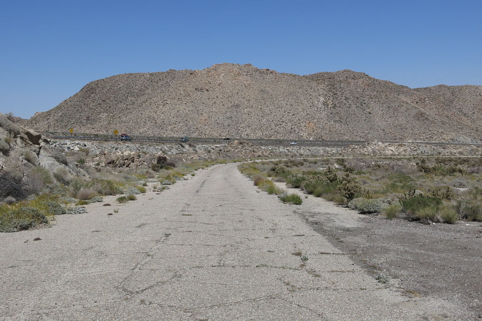
| This series of pictures shows the 1913 Mountain Springs Road alignment of U.S. 80 (with concrete poured in 1927 per the contractor's stamp). This extant section of concrete roadway is located just west of the Exit 80 interchange with Interstate 8 and passes through private property en route to the interchange. The last picture shows the length of Mountain Springs Road concrete between the Interstate 8 embankment and the Mountain Springs Road interchange (notable by the high wind walls that parallel the freeway). Note that the original road used to proceed straight through this area, and it was cut off by the freeway's construction. Another long stretch of concrete is accessible on the east side of the interchange. Photos taken 04/20/13. |
|
|
The date stamps for the Mountain Springs Road concrete reads "Jahn & Bressi Contractors 5-6-1927" along with the station number. These two date stamps are nearly identical and located next to each other toward the west end of the extant section of concrete roadway on Mountain Springs Road. Photos taken 04/20/13. |
|
|
|
|
|
| This series of pictures shows the 1940s Mountain Springs Road alignment of U.S. 80 just west of the Exit 80 interchange with Interstate 8. Mountain Springs Road as it proceeds downhill from a dead end at a freeway embankment. As the old road curves alongside the freeway, the Sunrise Powerlink and the Interstate 8 interchange (Exit 80) with its wind walls come into view. The last picture of this series shows the rusted remnant guardrail that at one time was painted white. Photos taken 04/20/13. |
|
|
The 1940s alignment approaches and meets the 1913 Mountain Springs Road alignment. Turn left on the older alignment to connect to Interstate 8 Exit 80, which is the only way to depart this area without four-wheel drive. Note that the 1940s alignment proceeds straight ahead and joins the eastbound lanes of Interstate 8 into In-Ko-Pah Gorge. The 1913 alignment turns left to follow the concrete road to approach the gorge from another angle. Travelers on Interstate 8 east will see the remnants of the old concrete road within the In-Ko-Pah Gorge. Photos taken 04/20/13. |
|
Eastbound Mountain Springs Road (Historic U.S. 80) approaches Interstate 8 at the Mountain Springs Road interchange (Exit 80). Ahead, Mountain Springs Road connects to another concrete segment of Old U.S. 80 that ultimately leads to a dead end. Through traffic should return to the freeway here. Photos taken 04/20/13. |
| Historic U.S. 80 and Imperial County S-80 east |
|---|
|
|
Now at the bottom of In-Ko-Pah Gorge in the community of Ocotillo, this is the first Imperial County S-80 reassurance shield along eastbound Historic U.S. 80 as the former U.S. highway leaves Ocotillo and travels toward Plaster City and Coyote Wells. This area changed in 2013 with the construction of a large wind farm and turbines in Ocotillo at the base of In-Ko-Pah Gorge and Devils Canyon. Photos taken 04/19/08. |
|
|
|
The pavement surface on this section of Old U.S. 80 leaves something to be desired, as asphalt covers old twin-slab concrete. It is a bit rough in places. A few billboards line the highway, but those are targeted for nearby Interstate 8 traffic, since the superhighway is only a short distance south of here running parallel to Historic U.S. 80. Also on the south side of the old highway is the San Diego & Arizona Eastern Railroad, which is also known as the San Diego & Imperial Valley Railroad and the Carrizo Gorge Railway. At Plaster City, this railroad merges with the Union Pacific Railroad coming from the north. Photos taken 04/19/08 and 10/14/06. |
|
|
|
|
|
| Imperial County S-80 proceeds east through the uninhabited desert. Several dry washes pass under the highway, and bridges are in place to carry the old road over the washes and ditches. In times of flood, waters will pass under the road rather than washing it away. But most times of the year, the washes are completely dry, owing to the limited rainfall this area sees in a given year. Photos taken 10/14/06. |
|
|
|
|
|
| These bridges were largely constructed as wood stringer/multi-beam or girder, with anywhere between two and 16 spans. These bridges were constructed in 1932 and reconstructed in 1949. The bridge construction timeline is consistent with much of the roadway construction dates in San Diego County, where concrete was poured for U.S. 80 in the Laguna Mountains between 1929 and 1933. Photos taken 10/14/06. |
|
|
|
|
|
| While some terrain changes are evident along this section of the historic route, the desert is largely level except for the occasional wash or ditch. In the distance, the 500kV Southwest Powerlink is evident. In 2012, this view changed somewhat with the construction of the companion 500kV Sunrise Powerlink. This resulted in two towers appearing alongside each other along this stretch of S-80. Photos taken 10/14/06. |
|
|
|
|
|
| Continuing east along the route between Ocotillo and Plaster City, CR S-80 (Evan Hewes Highway) sees still more bridges that cross over seasonal washes/ditches and dry streambeds that carry floodwaters during storms. A common design theme is the wooden approaches and sub-structure for the bridge from the original 1932 construction. These bridges have held up well through the years, partially due to the lack of precipitation in this arid desert in the rainshadow of the Laguna Mountains. Compare the look of the area just after noon vs. just before sunset. Photos taken 10/14/06 and 08/20/06. |
|
|
|
|
|
| This series of pictures takes a closer look at another, similarly themed bridge along CR S-80 in the Yuha Desert, which is technically part of the Sonoran Desert. Guardrail that was in standard use in the 1950s remained in use in 2006 on the bridge approaches. Most of these bridges seem to date from the 1940s. Photos taken 08/20/06 and 10/14/06. |
|
|
|
|
|
| As CR S-80 proceeds east through the Yuha Desert, the highway passes through desolate lands with sparse development. Ahead, the 500kV Southwest Powerlink (operated by San Diego Gas & Electric) passes over the county highway. In 2012, the companion 500kV Sunrise Powerlink began operation, resulting in a second tower running alongside the one shown here from 2006. Photos taken 08/20/06 and 10/14/06. |
|
|
|
|
|
| Eastbound Imperial County S-80 (Evan Hewes Highway) approaches Plaster City, an unincorporated community largely dominated by the gypsum quarry located there. As of 2012, the quarry was operated by United States Gypsum (USG); while based in Chicago, Illinois, USG's site lists Plaster City as one of its locations producing gypsum rock and wallboard. Plaster city's elevation is 105 feet; the elevation will continue to lower as we travel further east until we are below sea level in Seeley and El Centro. Photos taken 08/20/06 and 10/14/06. |
|
|
|
|
|
| Imperial County S-80 (Evan Hewes Highway) passes through Plaster City and passes by the USG office. The mining operation is a marked change from the other segments of U.S. 80 that pass through remote desert. An Imperial Irrigation District (IID) power line transmits electricity to the mine; it will follow the road from here east toward Seeley and El Centro. Photos taken 08/20/06 and 10/14/06. |
|
|
|
|
|
| Imperial County S-80 proceeds east between Plaster City and Seeley. A set of Imperial Irrigation District power lines follows the county highway. Older sections of single slab concrete can be seen alongside the more modern roadway southwest of Plaster City. Photos taken 08/20/06 and 10/14/06. |
|
Eastbound Imperial County S-80 (Evan Hewes Highway) approaches Dunaway Road, which travels south to connect to Interstate 8 at Exit 101. Continue straight ahead on Evan Hewes Highway to Seeley. Photo taken 10/14/06. |
|
Continuing east, Imperial County S-80 (Evan Hewes Highway) approaches Brown Road, which travels north to Centinela State Prison. Photo taken 10/14/06. |
|
The highway next crosses over the Westside Main Canal, which brings irrigation water from the Colorado River into the Imperial Valley for farming and ranching purposes. As a result, Historic U.S. 80 will suddenly shift from a desert landscape into an irrigated farming landscape. Photo taken 10/14/06. |
|
Farms line both sides of Imperial County S-80 (Evan Hewes Highway) east of the Westside Main Canal and near Jeffrey Road. Photo taken 10/14/06. |
|
The agricultural look and feel of Historic U.S. 80 will remain as we cross the Imperial Valley. We are gradually losing elevation as we trend toward the New River, a tributary of the Salton Sea and lowest point along Historic U.S. 80. Photo taken 10/14/06. |
|
Imperial County S-80 (Evan Hewes Highway) crosses the New River; this area represents the lowest point along the highway in California, with an elevation of around -52 feet below sea level. Originating in Mexicali, Baja California, Mexico, the New River carries agricultural and urban runoff north across the International Border into California. The river continues to lose elevation gradually, emptying into the Salton Sea north of here. Due to its non-natural source of water and continuous, year-round flow of polluted runoff, the New River is a source of challenging environmental needs with authorities on both sides of the border making efforts to reduce pollution and finding ways to mitigate the polluted waterway. Photo taken 10/14/06. |
|
Eastbound Imperial County S-80 (Evan Hewes Highway) meets Imperial County S-29 (Drew Road) at this stop sign in the unincorporated community of Seeley (population 1,739 as of the 2010 Census, elevation -36 feet below sea level). Turn right for S-29 south to Interstate 8 and California 98 en route to Calexico. Turn left for Haskell Road north into downtown Seeley. Ahead, CR S-80 proceeds east toward El Centro. Historically, this intersection was the original western terminus of California 98 before it was rerouted to its current terminus near Coyote Wells and Ocotillo in 1953. Now, this intersection marks the northern terminus of CR S-29, a fairly short (eight-mile-long) county route that links Seeley with Mount Signal via Drew Road (former California 98). Photo taken 10/14/06. |
|
|
Leaving the Drew Road intersection in Seeley, this CR S-80 east reassurance shield is posted after the Imperial County S-29 (Drew Road) intersection near Seeley. S-80 is fairly well signed between Ocotillo and El Centro. Photos taken 10/14/06 and 08/20/06. |
|
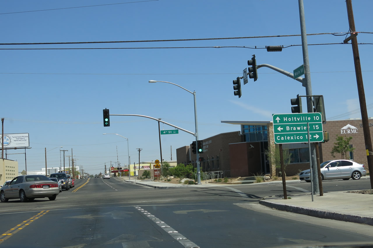
This mileage sign along eastbound Imperial County S-80 (Evan Hewes Highway) provides the distance to Naval Air Facility (NAF) El Centro (two miles) and the city of El Centro (seven miles). Photo taken 10/14/06. |
|
Eastbound Imperial County S-80 (Evan Hewes Highway) approaches Bennett Road (next stop sign), which travels north to Naval Air Facility (NAF) El Centro. Continue straight ahead for El Centro. Photo taken 10/14/06. |
|
This Imperial County S-80 route marker is posted along eastbound Evan Hewes Highway after the Bennett Road intersection between Seeley and El Centro. Photo taken 10/14/06. |
|
Eastbound Imperial County S-80 (Evan Hewes Highway) approaches Silsbee Road at the next four-way stop sign. Photo taken 10/14/06. |
|
Soon thereafter, eastbound Imperial County S-80 (Evan Hewes Highway) approaches Imperial County S-30 (Forrester Road). CR S-30 is a long, north-south county route that begins at Mt. Signal and extends north to Westmorland and ultimately Calipatria, where it ends at California 111 and California 115. Photo taken 10/14/06. |
|
Use Imperial County S-30 (Forrester Road) south to Interstate 8 and California 98. Photo taken 10/14/06. |
|
|
This 1962 sign points the way to Westmorland via Imperial County S-30 (Forrester Road) north. Based on the age of the sign, it was in place and in use back when S-80 was signed as U.S. 80. The back of the sign shows it is a porcelain enamel sign by its white plates and C-62 insignia, which confirms the date of installation. Porcelain enamel signs with button copy lettering was common back in the 1960s but is increasingly rare on California's highways in the 2000s. Photos taken 10/14/06. |
|
Eastbound Imperial County S-80 (Evan Hewes Highway) meets Imperial County S-30 (Forrester Road) at this four-way stop sign. Photo taken 10/14/06. |
|
An Imperial County S-80 east reassurance shield is posted along eastbound Evan Hewes Highway after the intersection with Imperial County S-30 (Forrester Road). Continue straight ahead for S-80 east to El Centro and the junction with California 86 (Historic U.S. 99). Photo taken 10/14/06. |
|
Agricultural development is increasingly evident as Imperial County S-80 (Evan Hewes Highway) proceeds east between Imperial County S-30 (Forrester Road) and Austin Road (near the Central Main Canal). Photo taken 10/14/06. |
|
Eastbound Imperial County S-80 (Evan Hewes Highway) meets Austin Road at this four-way stop sign. Austin Road travels northeast to Brawley (alternate to California 86, staying west of Imperial) and south alongside the Central Main Canal to provide local and ranch access. There is no access to Interstate 8 via Austin Road southbound. Photo taken 10/14/06. |
|
Imperial County S-80 (Evan Hewes Highway) crosses the Central Main Canal on this 1940 bridge. Note the 1940 date stamp embedded in the bridge abutment concrete. Photo taken 10/14/06. |
|
An Imperial County S-80 reassurance shield is posted along eastbound Historic U.S. 80 (Evan Hewes Highway) after the Austin Road intersection. Photo taken 10/14/06. |
|
Eastbound Imperial County S-80 (Evan Hewes Highway) enters the city of El Centro and becomes known as Adams Avenue. The city of El Centro is the seat of Imperial County. El Centro had a population of 42,598 as of the 2010 Census, sits at an elevation of -39 feet below sea level, and was incorporated on April 16, 1908. The next traffic signal ahead is with La Brucherie Road, which travels north to the city of Imperial and south to cross Interstate 8 (no interchange) and eventually change into Ferrell Road to connect to California 98 west of Calexico. Photo taken 10/14/06. |
|
Between La Brucherie Road and Imperial Avenue, Imperial County S-80 (Adams Avenue) widens to four lanes with a median. A notable relic of Adams Avenue's former status as a state highway is the divoted curbing found along the concrete curb of the median barrier. Photo taken 10/14/06. |
|
Eastbound Imperial County S-80 (Adams Avenue) approaches California 86 and Business Loop I-8. Only California 86 is signed at this junction sign. At the upcoming intersection, turn left for California 86 (Imperial Avenue) north to the cities of Imperial and Brawley, or turn right for Business Loop I-8 (Imperial Avenue) south to Interstate 8. Ahead, Adams Avenue will carry California 86 south, Business Loop I-8 east, and Imperial County S-80 east. Photo taken 10/14/06. |
|
The upcoming intersection between CR S-80, California 86, and Business Loop I-8 also marks the beginning of an overlap between historic routes U.S. 80 and U.S. 99. Adams Avenue is not the original route of U.S. 80 through El Centro; that distinction belongs to Main Street, which parallels Adams Avenue four blocks south of here. To see Historic U.S. 80 (Main Street), turn south on Imperial Avenue and turn left (east) onto Main Street. Photo taken 10/14/06. |
|
This mileage sign along eastbound Imperial County S-80 (Adams Avenue) provides the distance to Brawley via California 86 north (14 miles) and the distance to Yuma via S-80 and Interstate 8 east (59 miles). Photo taken 10/14/06. |
|
Eastbound Imperial County S-80 (Adams Avenue) meets Imperial Avenue at this signalized intersection. Turn left for California 86 north to Brawley or turn right for Business Loop I-8 south to Interstate 8. Photo taken 10/14/06. |
| Historic U.S. 80 east & Historic U.S. 99 south |
|
|
|
|
|
| Historic U.S. 80-99 (Main Street) proceed east through downtown El Centro. This portion of Main Street was likely to have been signed as both U.S. 80 and U.S. 99, although neither route is currently signed on Main Street. Originally, Main Street was U.S. 80 and U.S. 99, but those routes were later moved to Fourth Street and Adams Avenue as a bypass of downtown El Centro. Shops and businesses line the central commercial district of El Centro. Photos taken 04/20/13. |
|
|
|
|
|
|
|
|
|
|
|
|
Historic U.S. 80 and Historic U.S. 99 split at the intersection of Main Street and Fourth Street. Turn left for California 86 north, Business Loop I-8 west, and Imperial County S-80 via Fourth Street and Adams Avenue. Proceed ahead for Imperial County S-80 and Historic U.S. 80 east to Holtville. Turn right for California 86 south, Historic U.S. 99 south, and Business Loop I-8 east to Interstate 8 and south to Heber and Calexico. Photos taken 04/20/13. |
| Historic U.S. 80 & Imperial County S-80 east |
|
Now leaving the intersection with Business Loop I-8 and California 86, eastbound Imperial County S-80 (Main Street) again travels on its own again through eastern El Centro. Photo taken 04/01/06. |
|
The area east of El Centro is generally industrial, and much of the old route is falling apart somewhat due to truck traffic. Photo taken 04/01/06. |
|
Storage facilities, rentals, and industrial services line Imperial County S-80 (Old U.S. 80) east of El Centro. Note the use of Botts Dots as pavement marking. Photo taken 04/01/06. |
|
The next major intersection along eastbound U.S. 80 is the junction with Imperial County S-31 (Dogwood Road). A gas station is located on the southwestern and northwestern corners. Photo taken 04/01/06. |
|
Eastbound CR S-80 meets Dogwood Road (CR S-31) at this signalized intersection. On this day, the temperature was a balmy 72 degrees. On many days in the summer, daytime temperatures get well into the 100 degree range. Photo taken 04/01/06. |
|
Old U.S. 80 continues east after Dogwood Road. There are no reassurance shields for Imperial County S-80 after the S-31 intersection. Photo taken 04/01/06. |
|
Imperial County S-80 (Evan Hewes Highway) turns slightly northeast, while Gillett Road continues due east. Photo taken 10/14/06. |
|
At the Cooley Road intersection, Imperial County S-80 (Old U.S. 80) leaves the city of El Centro and enters unincorporated county. Photo taken 04/01/06. |
|
The powerlines in the distance mark the pending junction with California 111. Photo taken 04/01/06. |
|
Eastbound U.S. 80 (Imperial County S-80) approaches Old Highway 111 (frontage road) and California 111 expressway. Photo taken 04/01/06. |
|
The first traffic signal at the junction with California 111 is with Old Highway 111, followed by the intersection with the state route. A transmission power line tower sits between the old alignment and the new expressway. Photo taken 04/01/06. |
|
A set of shields for Imperial County S-80 and California 111 are posted immediately prior to the California 111 expressway intersection. Photo taken 10/14/06. |
|
At the second traffic signal, turn left to follow California 111 north to Brawley and Indio or turn right to follow California 111 south to Calexico. Through its entire route south of Brawley, California 111 is a four-lane divided highway. The Brawley Bypass, which opened on October 30, 2012, offered an expressway link around Brawley to connect the California 111 and California 86 expressways together, making for a continuous four-lane route between Calexico, El Centro, Brawley, the Coachella Valley, and Indio. Photo taken 10/14/06. |
Page Updated April 27, 2013.