
California 125 South - SR 52 to SR 94

This view looks south from Mariposa Street onto California 125 (Helix Freeway) south toward the California 94 interchange. This is the oldest section of California 125 and actually opened as part of California 67. Photo taken 10/22/06.
| California 125 south | |
|---|---|
 |
After the Mission Gorge Road traffic signal, this view shows California 125 south as it begins in Santee and passes under the California 52 extension en route to El Cajon and La Mesa. California 125 starts its journey in the city of Santee (population 52,975 as of 2000 Census, elevation 350 feet, incorporated on December 1, 1980). Photo taken 03/28/09. |
 |
As traffic from California 52 east merges onto California 125 south, this mileage sign provides the distance to the next three exits: Exit 20B, Grossmont College Drive; Exit 20A, Navajo Road; and Exit 18B, Fletcher Parkway. Photo taken 08/23/10. |
 |
California 125 immediately begins to gain elevation as it leads toward Grossmont Summit. Photo taken 08/23/10. |
 |
A second interchange sequence sign provides the distance to the next three exits along California 125 south: Exit 20B, Grossmont College Drive; Exit 20A, Navajo Road; and Exit 18B, Fletcher Parkway. Photo taken 08/23/10. |
 |
California 125 leaves Santee and enters the city of El Cajon (population 94,869 as of 2000 Census, elevation 435 feet, and incorporated on November 12, 1912). The freeway avoids downtown El Cajon and will skirts its western edge, staying well above the listed elevation. Photo taken 08/23/10. |
 |
Use Exit 20B to Grossmont College, a public community college that serves the eastern suburbs and city of San Diego. Photo taken 08/23/10. |
 |
Southbound California 125 meets Exit 20B, Grossmont College Drive to Grossmont College and Fanita Parkway. The next exit along California 125 south is Exit 20A, Navajo Road. Photo taken 08/23/10. |
 |
Immediately thereafter, California 125 south meets Exit 20A, Navajo Road. The off-ramp is located just prior to the Grossmont College Drive underpass, and the resultant exit is a collector distributor lane (so through traffic may use this off-ramp). Photo taken 08/23/10. |
 |
Now on the collector distributor lanes for Exit 20A, traffic merges onto the c-d lanes from Grossmont College Drive. Stay right to connect to Navajo Road or merge left to return to California 125. Photo taken 08/23/10. |
 |
Back on the mainline, an interchange sequence sign provides the distance to the next three exits along California 125 south: Exit 18B, Fletcher Parkway and Amaya Drive; Exit 18A, Interstate 8 (Kumeyaay Highway) (Alvarado Freeway); and Exit 17B, Grossmont Boulevard. Photo taken 08/23/10. |
 |
The California 125 south collector distributor lanes divide, with the right lane connecting to Navajo Road and the left lane returning to the main lanes of California 125 south. Photo taken 08/23/10. |
 |
A California 125 south reassurance shield is posted after the on-ramp from the collector distributor lanes from Grossmont College Drive. Ahead, a second merge point brings traffic onto the southbound freeway from Navajo Road. Photo taken 08/23/10. |
 |
The next exit along California 125 south is Exit 18B, Fletcher Parkway and Amaya Drive in La Mesa. Photo taken 08/23/10. |
 |
 |
California 125 was largely constructed through Santee, El Cajon, and northern La Mesa in phases during the late 1990s and early 2000s. The section between Fletcher Parkway and Navajo Road opened in March 2001, and the section between Navajo Road and Grossmont College Drive opened in mid-2002. These two pictures show then-under construction California 125 looking south in Fletcher Hills from a hill just south of Navajo Road. Now a freeway passes through here. Photos taken 06/06/99. |
 |
After Fletcher Parkway, the second exit from California 125 south is Exit 18A, Interstate 8 east to El Centro and west to San Diego and the Beaches. Photo taken 08/23/10. |
 |
Another California 125 south reassurance shield is posted between Navajo Road and Fletcher Parkway. The short distance between these two exits took us over an hour to walk before construction started on the project in the late 1990s. Photo taken 08/23/10. |
 |
Southbound California 125 reaches Exit 18B, Fletcher Parkway and Amaya Drive. This interchange serves the city of La Mesa, the "Jewel of the Hills." La Mesa had a population of 54,749 as of the 2000 Census, sits at an elevation of 528 feet, and was incorporated on February 16, 1912. California 125 will remain in La Mesa as it passes over Grossmont Summit and proceeds south toward the California 94 interchange. Photo taken 08/23/10. |
 |
As traffic departs for Fletcher Parkway, an overhead guide sign announces that the next exit from California 125 south is Exit 18A, Interstate 8 east to El Centro and west to San Diego and the Beaches. Photo taken 08/23/10. |
 |
The right two lanes of California 125 south become exit only for Exit 18A, Interstate 8 east to El Centro and west to San Diego and the Beaches. This major east-west freeway carries traffic from San Diego east to Arizona via the Imperial Valley. El Centro is the largest city in the Imperial Valley, a large farming area in the Colorado Desert. East of the Colorado River, Interstate 8 proceeds into Yuma and Gila Bend before ending at Interstate 10 in Casa Grande. To the west, Interstate 8 passes through Mission Valley, meets Interstate 15 and Interstate 5, and ends at Sunset Cliffs Boulevard near the mouth of the San Diego River. Photo taken 08/23/10. |
 |
Southbound California 125 reaches Exit 18A, Interstate 8 east to El Centro and west to San Diego and the Beaches. Photo taken 08/23/10. |
 |
Now on the transition ramp to Interstate 8, the left lane connects to Interstate 8 east to El Centro, and the right lane connects to Interstate 8 west to San Diego and the Beaches. Photo taken 06/24/07. |
 |
This interchange sequence sign along California 125 south provides the distance to the next three exits: Exit 17B, Grossmont Boulevard; Exit 17A, California 94 east and Spring Street; and Exit 15, California 94 west (left exit). All of these exits serve the city of La Mesa. At this point, California 125 reaches the top of Grossmont Summit. The freeway will descend from here toward the California 94 interchange. Photo taken 08/23/10. |
 |
Ramp meters control the flow of traffic through the Interstate 8 interchange. Since a great deal of new traffic joins California 125 south from the transition from Interstate 8 west, the main lanes narrow to just one lane after this ramp meter. Photo taken 08/23/10. |
 |
Southbound California 125 reaches Exit 17B, Grossmont Boulevard. This off-ramp is located within the Interstate 8 interchange complex, which was expanded to its current configuration in 1993. Between Interstate 8 and California 94, the California 125 was originally built as California 67/Helix Freeway in the mid to late 1950s. California 125 will become a six-lane freeway for much of this distance, with eventual plans for widening still on the books. Photo taken 08/23/10. |
 |
The freeway narrows to one through lane along southbound (note the lane markings). The incoming on-ramp ahead brings traffic from Interstate 8 onto southbound. Photo taken 08/23/10. |
 |
California 125 again widens out with the introduction of traffic from California 94. The freeway will eventually narrow to its original 1960s-era width, with three lanes southbound. Photo taken 08/23/10. |
 |
The next exit along California 125 south is Exit 17A, California 94 and Spring Street (one mile). Photo taken 08/23/10. |
 |
The oldest segment of California 125 is this six-lane section of Helix Freeway. The concrete lanes here date back to the mid-1960s. Photo taken 08/23/10. |
 |
California 125 passes under Mariposa Street, which was built in 1957. This is one of the oldest structures on this freeway, most of which was built in the 1990s and 2000s. Photo taken 08/23/10. |
 |
The off-ramp to Exit 17A connects directly to Spring Street. The connection to California 94 east is via Spring Street east. There is no direct connection ramp. Photo taken 08/23/10. |
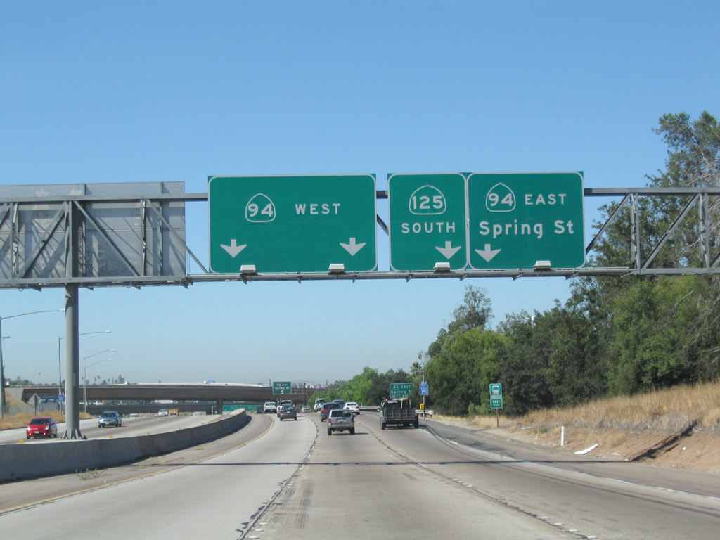 |
This guide sign provides the lane allocation for Exit 15, California 94 west (left exit), California 125/South Bay Freeway south, and Exit 17A, Spring Street to California 94 east. Photo taken 08/23/10. |
 |
Spring Street travels north into downtown La Mesa and connects to Campo Road east. Campo Road is the original alignment of California 94. Photo taken 08/23/10. |
 |
Southbound California 125 reaches Exit 17A, Spring Street to California 94 east. Photo taken 08/23/10. |
 |
The left three lanes connect to Exit 15, California 94 (Martin Luther King Jr. Freeway) west to Lemon Grove and San Diego. The right lane offers the continuation of California 125 south to Chula Vista. Photo taken 08/23/10. |
 |
Southbound California 125 reaches the left-exit for California 94 (Martin Luther King Jr. Freeway) west to Lemon Grove and San Diego. Traffic from mainline California 94 west will merge together with this off-ramp after California 125 ascends onto a massive bridge that carries the freeway over the 94-125 interchange. Photo taken 08/23/10. |
 |
 |
 |
This series of photos follows California 125 as it passes high above the California 94 interchange at the southern edge of La Mesa. Ahead, California 125 will enter unincorporated San Diego County and approach the community of Spring Valley. Photos taken 08/23/10. |
 |
 |


Page Updated January 27, 2013.
|
About Contact Glossary |
In The News Testimonials Interstate Guide |
Social Media:
 |
|
© 2000-23 AARoads.com | All Rights Reserved | Privacy Policy / Terms of Use
|
||