
California 92 East

This view looks east along the California 92 freeway after the U.S. 101 freeway. Photo taken 02/18/12.
| California 92 east | |
|---|---|
 |
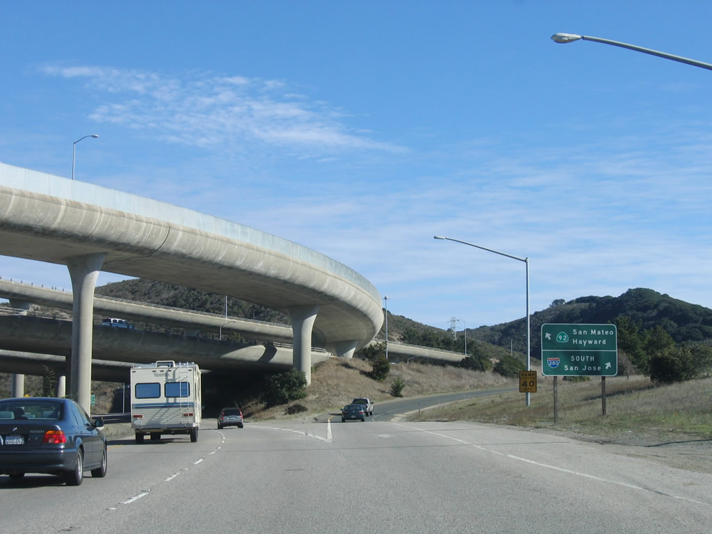
Meeting Canada Road at this signalized intersection, California 92 (J. Arthur Younger Freeway) begins as a freeway east toward San Mateo, Foster City, and Hayward. The first exit on this nascent freeway is the connector to Interstate 280 (Father Junipero Serra Freeway) south to San Jose. Photo taken 11/27/05. |
 |
The left two lanes continue east along California 92 (J. Arthur Younger Freeway), while the right lane departs for Interstate 280 (Father Junipero Serra Freeway) south to San Jose. Photo taken 11/27/05. |
 |
The Interstate 280 interchange is a massive stack, with a towering transition ramp from Interstate 280 south to California 92 east. Photo taken 11/27/05. |
 |
Eastbound California 92 (J. Arthur Younger Freeway) reaches Exit 8B, Interstate 280 north to San Francisco. Photo taken 11/27/05. |
 |
The next exit on eastbound California 92 (J. Arthur Younger Freeway) is Exit 9A, Ralston Avenue east to the city of Belmont and Polhemus Road north to The Highlands. Photo taken 11/27/05. |
 |
Eastbound California 92 (J. Arthur Younger Freeway) reaches Exit 9A, Ralston Avenue east to the city of Belmont and Polhemus Road north to The Highlands. Photo taken 11/27/05. |
 |
This mileage sign provides the distance to the next three exits on eastbound California 92: Exit 9B, De Anza Boulevard; Exit 10, West Hillsdale Boulevard; and Exit 11, Alameda de las Pulgas. Photo taken 11/27/05. |
 |
This California 92 reassurance shield is posted at the on-ramp from Ralston Avenue/Polheus Road. Photo taken 11/27/05. |
 |
Eastbound California 92 reaches Exit 9B, De Anza Boulevard. This diamond interchange serves the city of San Mateo. Home to 92,482 people as of the 2000 Census, San Mateo experienced a 8.2% growth rate between 1990 and 2000. Photo taken 11/27/05. |
 |
The next exit on California 92 (J. Arthur Younger Freeway) is Exit 10, Hillsdale Boulevard. Hillsdale Boulevard parallels California 92 between Exit 14B and Exit 10 to the south of the freeway. Use this exit to the College of San Mateo via Hillsdale Boulevard west. Photo taken 11/27/05. |
 |
Another California 92 east reassurance shield is posted after the De Anza Boulevard on-ramp. Photo taken 11/27/05. |
 |
The right lane becomes exit only for Exit 10, Hillsdale Boulevard. Photo taken 11/27/05. |
 |
The next four exits on California 92 (J. Arthur Younger Freeway) are Exit 10, Hillsdale Boulevard; Exit 11, Alameda de las Pulgas; Exit 12A, California 82 (El Camino Real) south; and Exit 12B, California 82 (El Camino Real) north. Photo taken 11/27/05. |
 |
Eastbound California 92 (J. Arthur Younger Freeway) reaches Exit 10, Hillsdale Boulevard. Photo taken 11/27/05. |
 |
The next exit on eastbound California 92 (J. Arthur Younger Freeway) is Exit 11, Alameda de las Pulgas. Photo taken 11/27/05. |
 |
The next four exits on California 92 (J. Arthur Younger Freeway) are Exit 11, Alameda de las Pulgas; Exit 12A, California 82 (El Camino Real) south; Exit 12B, California 82 (El Camino Real) north; and Exit 12C, Delaware Street. Photo taken 11/27/05. |
 |
Use Alameda de las Pulgas north to Hillsborough and south to Belmont. Parts of this road were built to divided highway standards south of California 92. Photo taken 11/27/05. |
 |
Eastbound California 92 (J. Arthur Younger Freeway) reaches Exit 11, Alameda de las Pulgas. The next interchange is Exits 12A-B, California 82 (El Camino Real). Photo taken 11/27/05. |
 |
The next five exits on eastbound California 92 (J. Arthur Younger Freeway) are Exit 12A, California 82 (El Camino Real) south; Exit 12B, California 82 (El Camino Real) north; Exit 12C, Delaware Street; Exit 13A, U.S. 101 (Bayshore Freeway) south to San Jose; and Exit 13B, U.S. 101 (Bayshore Freeway) north to San Francisco. Photo taken 11/27/05. |
 |
Eastbound California 92 (J. Arthur Younger Freeway) reaches Exit 12A, California 82 (El Camino Real) south to the Hillsdale community of the city of San Mateo. The next exit is Exit 12B, California 82 (El Camino Real) north to downtown San Mateo, Mills Hospital, Central Park, and a Caltrain Station. Photo taken 11/27/05. |
 |
Immediately thereafter, eastbound California 92 (J. Arthur Younger Freeway) reaches Exit 12B, California 82 (El Camino Real) north to downtown San Mateo. The next exit is Exit 12C, Delaware Street, which also connects to a Caltrain station. Photo taken 11/27/05. |
 |
Use Exit 12C, Delaware Street to 19th Avenue, which parallels California 92 on the south side of the freeway. Between Alameda de las Pulgas and U.S. 101, California 92 is also known as the 19th Avenue Freeway. Photo taken 11/27/05. |
 |
Eastbound California 92 (J. Arthur Younger Freeway) reaches Exit 12C, Delaware Street. The next exit is Exits 13A-B, U.S. 101 (Bayshore Freeway). Photo taken 11/27/05. |
 |
The next four exits along California 92 east are: Exits 13A-B, U.S. 101 (Bayshore Freeway); Exit 14A, Mariners Island Boulevard; and Exit 14B, Foster City Boulevard. Photo taken 11/27/05. |
 |
Eastbound California 92 reaches Exit 13A, U.S. 101 (Bayshore Freeway) south to San Carlos, Redwood City, and San Jose. The next ramp connects California 92 east to U.S. 101 north to San Francisco. California 92 continues east toward Foster City and the San Mateo-Hayward Bridge. Photo taken 11/27/05. |
 |
This view looks at the transition ramp from U.S. 101 south to California 92 east. Photo taken 02/18/12. |
 |
 |
The next exit along California 92 east is Exit 14A, Mariners Island Boulevard and Edgewater Boulevard. Use Edgewater Boulevard south into Foster City; use Mariners Island Boulevard north to the Marina Lagoon and Shoreline Park in San Mateo. Photos taken 02/18/12 and 07/05/06. |
 |
 |
Eastbound California 92 (J. Arthur Younger Freeway) reaches Exit 14A, Mariners Island Boulevard and Edgewater Boulevard. Photos taken 02/18/12 and 07/05/06. |
 |
 |
The next exit along California 92 east is Exit 14B, Foster City Boulevard. The city of Foster City encompasses four square miles. Foster City is notable for being almost entirely located on landfill in what would otherwise be San Francisco Bay. With the Marina Lagoon acting as Foster city's western border, the city is almost entirely surrounded by water. Per the 2000 Census, 28,803 people call Foster City home. Photos taken 02/18/12 and 07/05/06. |
 |
 |
The right two lanes connect California 92 east with Exit 14B, Foster City Boulevard. This is the last exit before California 92 crosses the San Francisco Bay via the San Mateo-Hayward Bridge. Photos taken 02/18/12 and 07/05/06. |
 |
California 92 enters Foster City. Photo taken 02/18/12. | |
 |
A roadside sign advises that Exit 14B is the last exit along California 92 east prior to crossing the San Mateo Bridge. Photo taken 02/18/12. | |
 |
 |
Eastbound California 92 reaches Exit 14B, Foster City Boulevard. After this exit, California 92 will cross the San Francisco Bay via the San Mateo-Hayward Bridge. There are no services for 12 miles. Despite the "toll crossing entrance" sign, tolls are not collected in the eastbound direction (only in the westbound direction). Photos taken 02/18/12 and 07/05/06. |
 |
 |
An overhead sign for California 92 provides the East Bay control city of Hayward and the Central Valley destination of Stockton. California 92 does not travel all the way to Stockton, but it does connect to Interstate 580 via either Interstate 880/Interstate 238 or via California 238 (Foothill Boulevard). Photos taken 02/18/12 and 07/05/06. |
 |
A California 92 east reassurance shield assembly is posted after the on-ramp from Foster City Boulevard. The high-rise portion of the San Mateo-Hayward Bridge comes into view ahead. Photo taken 07/05/06. | |
 |
This sign advises that California 92 is named in honor of J. Arthur Younger, a United States Representative from California (11th District). A Republican, Mr. Younger served in office from 1952 until he died from leukemia in 1967. Photo taken 07/05/06. | |
| California 92 - San Mateo-Hayward Bridge east | ||
|---|---|---|
 |
 |
 |
Eastbound California 92 ascends the high section of the seven-mile San Mateo-Hayward Bridge. At the pinnacle of the steel girder bridge, motorists can see the causeway section of the San Mateo Bridge continuing another five miles across the bay until reaching mainland in Hayward. Note the lack of shoulders on the high section of the bridge. Photos taken 07/05/06. |
 |
 |
 |
After reaching the high point, California 92 descends to the causeway section, which continues for another five miles over water. Originally built as a crossing in 1929, the San Mateo-Hayward Bridge was replaced with the current span in 1967 and widened in 2004 to its current six-lane configuration with full shoulders on the causeway section. This upgrade was coupled with improvements along California 92's eastern approach from Interstate 880 to the toll plaza. Photos taken 07/05/06. |
 |
 |
 |
The causeway section gradually widens to incorporate full shoulders on both sides of the three travel lanes. A small emergency parking area is located ahead. The eastbound direction uses the older causeway. Photos taken 07/05/06. |
 |
Tall Pacific Gas and Electric (PG&E) power lines transmit electricity across San Francisco Bay. The towers follow California 92/San Mateo-Hayward Bridge closely as it crosses the bay. Photo taken 07/05/06. |
 |
Leaving Foster City and San Mateo County, eastbound California 92 enters the city of Hayward, the "Heart of the Bay." Encompassing 62.55 square miles, Hayward is the third largest city in the East Bay (only after Oakland and Fremont). Total population as of the 2000 Census was 140,030. Hayward was incorporated as a town in 1876 and as a city on September 18, 1928. We also enter Alameda County, which extends north to Oakland and south into Fremont. Photo taken 07/05/06. |
 |
The San Mateo-Hayward Bridge continues across San Francisco Bay. It looks mostly the same along the causeway section until the bridge reaches land. Photo taken 07/05/06. |
 |
The San Mateo-Hayward Bridge comes to an end as the westbound toll plaza comes into view. Photo taken 07/05/06. |
| California 92 east | |
|---|---|
 |
The next three exits along eastbound California 92 are: Exit 24, Clawiter Road; Exit 25A, Industrial Boulevard; and Exit 25B, Hesperian Boulevard. Photo taken 07/05/06. |
 |
The next exit along eastbound California 92 is Exit 24, Clawiter Road and Edens Landing Road. Photo taken 07/05/06. |
 |
Use Exit 24 to the Hayward Shoreline Interpretive Center via Clawiter Road north to Breakwater Avenue west. The center is located along the Hayward Regional Shoreline amidst the salt evaporation ponds. Photo taken 07/05/06. |
 |
Eastbound California 92 reaches Exit 24, Clawiter Road and Edens Landing Road. Edens Landing Road travels into the industrial areas south of California 92. Photo taken 07/05/06. |
 |
The next four exits along eastbound California 92 are: Exit 25A, Industrial Boulevard; Exit 25B, Hesperian Boulevard; and Exits 26A-B, Interstate 880 (Nimitz Freeway). Photo taken 07/05/06. |
 |
The next exit along eastbound California 92 is Exit 25A, Industrial Boulevard. Use Industrial Boulevard south to Tennyson Road east and north to Clawiter Road. Photo taken 07/05/06. |
 |
Eastbound California 92 (J. Arthur Younger Freeway) reaches Exit 25A, Industrial Boulevard. The next exit is Exit 25B, Hesperian Boulevard north to the unincorporated community of San Lorenzo. Photo taken 07/05/06. |
 |
Exit 25A is signed at the gore point only. The next exit (Hesperian Boulevard) travels north to Chabot College and Hayward Air Terminal. Photo taken 07/05/06. |
 |
The next three exits along eastbound California 92 are: Exit 25B, Hesperian Boulevard; Exit 26A, Interstate 880 (Nimitz Freeway) south to San Jose; and Exit 26B, Interstate 880 (Nimitz Freeway) north to Oakland and to Interstate 238-580 east to Stockton. Photo taken 07/05/06. |
 |
Eastbound California 92 reaches Exit 25B, Hesperian Boulevard north to Chabot College, Southland Mall, Hayward Air Terminal, and San Lorenzo. To the south, Hesperian Boulevard enters Union City and becomes Union City Boulevard. Photo taken 07/05/06. |
 |
Use Exit 26B, Interstate 880 (Nimitz Freeway) north to Oakland and to Interstate 238-580 east to Stockton. This connection is currently served by a loop ramp in a cloverleaf interchange, but the freeway interchange will be reconstructed to provide a high speed connection from California 92 east to Interstate 880 north. This is done in lieu of building a continuation of the California 92 freeway through downtown Hayward and connecting with Interstate 580 via California 238 (Foothill Boulevard). Photo taken 07/05/06. |
 |
Interstate 880 follows the Nimitz Freeway north to Oakland and south toward San Jose. Formerly known as California 17 until the mid-1980s, the freeway is the primary route from San Jose to Oakland along the east shore of San Francisco Bay. Freeway traffic should use Interstate 880 to make connections to adjoining freeways; California 92's freeway ends on the east side of Interstate 880. Photo taken 07/05/06. |
 |
The right lane becomes exit only for Exit 26A, Interstate 880 (Nimitz Freeway) south to San Jose. The second exit connects to Interstate 880 north to Oakland and to Interstate 238-580 east to Stockton. California 92 continues east briefly into downtown Hayward, where it ends. Photo taken 07/05/06. |
 |
Eastbound California 92 (J. Arthur Younger Freeway) reaches Exit 26A, Interstate 880 (Nimitz Freeway) south to San Jose. The next exit is Exit 26B, Interstate 880 north to Oakland and to Interstate 238-580 east to Stockton. Note the flashing yellow beacon for the end of the freeway section of California 92. Photo taken 07/05/06. |
 |
Now in the cloverleaf interchange, a new right lane becomes the exit ramp to Interstate 880 north. This ramp requires a sharp right turn. Photo taken 07/05/06. |
 |
Eastbound California 92 reaches Exit 26B, Interstate 880 (Nimitz Freeway) north to Oakland. California 92 downgrades to a surface street, following Jackson Street east to the terminus at its junction with California 185 and California 238 in downtown Hayward. Photo taken 07/05/06. |
 |
 |
California 92 ends at the junction with California 185 (Mission Boulevard) north, California 238 (Foothill Boulevard) north, and California 238 (Mission Boulevard) south. An end California 92 shield is posted along with a California 238 shield in downtown Hayward. Photos taken 12/30/04. |
 |
The left two lanes will transition only to California 185 (Mission Boulevard) north, while the middle three lanes connect directly onto California 238 (Foothill Boulevard) north to Interstate 580. The right lane also connects to California 238 (Mission Boulevard) south to California State University - East Bay (Hayward) and the cities of Union City and Fremont. The once-proposed freeway bypass of California 238 is unlikely to be constructed, and several right of way parcels are in the process of being sold by the city of Hayward. Photo taken 12/30/04. |
 |
Currently, a traffic signal governs the flow of traffic through this very busy intersection. Future plans for this intersection include a potential grade separation, but it this is still a preliminary concept. California 92 ends here, and California 238 takes over from here north to Interstate 580. Photo taken 12/30/04. |


Page Updated September 23, 2013.
|
About Contact Glossary |
In The News Testimonials Interstate Guide |
Social Media:
 |
|
© 2000-23 AARoads.com | All Rights Reserved | Privacy Policy / Terms of Use
|
||