| California 86 Expressway (former California 86S) south |
|
Traveling south along the California 86 expressway in the vicinity of Indio and Coachella. The very first segment of California 86 expressway was built between Interstate 10 and Dillon Road in the early 1970s, but the rest of the expressway remained unbuilt until 1993 when the Dillon Road bridge was built. Additional extensions of the route were built in 1998 and 2000, gradually taking the expressway south to the existing California 86 south of Coachella. After the Dillon Road interchange, the next signalized intersection along southbound California 86S is with 50th Avenue. Photo taken 03/14/09. |
|
This end freeway sign is posted along southbound California 86 at the 50th Avenue intersection. Photo taken 03/14/09. |
|
The next signalized intersection along southbound California 86 is with 52nd Avenue. Photo taken 03/14/09. |
|
Continuing south, the next signalized intersection along southbound California 86 expressway is with 62nd Avenue. Photo taken 03/14/09. |
|
Southbound California 86 crosses over California 111 and the railroad via this bridge. Photo taken 03/14/09. |
|
High voltage power lines cross California 86 after the California 111 bridge. Photo taken 03/14/09. |
|
The next signalized intersection along southbound California 86 is with California 195 (66th Avenue). Photo taken 03/14/09. |
|
A California 195 trailblazer is posted along with California 111 south at the 66th Avenue signalized intersection. At this intersection, California 111 turns off California 86 and proceeds southeast toward Mecca, Niland, Bombay Beach, and Calipatria. Photo taken 03/14/09. |
|
Southbound California 86 approaches California 195/Sixty-Sixth (66th) Avenue to California 111 south. Photo taken 03/14/09. |
|
Going back to 1999, California 86S was initially designated separately from mainline California 86 because the new expressway did not connect with California 86. The intent was to create a temporary or "supplemental" routing until the two discontinuous segments were joined. It took until 2012 for California 86S to be redesignated as California 86. This picture was taken on California 86S south at the California 195 (66th Avenue) intersection. At the time this picture was taken, the California 195 intersection was the end of the expressway, but it has since been extended south to rejoin with California 86 at 81st Avenue. Traffic had to take California 195 southwest to connect with California 86 south to Salton City and Brawley. Photo taken 09/99. |
| Former California 86 south |
|
Returning to the former alignment of California 86 south along Harrison Street through the city of Coachella. Here, southbound Harrison Street approaches Avenue 50 (next traffic signal). Photo taken 05/07/06. |
|
Southbound Former California 86 (Harrison Street) approaches Valley Road and Calle Verde. Photo taken 05/07/06. |
|
Leaving Coachella, this mileage sign used to provide the distance to Salton City (30 miles), El Centro (80 miles), and Calexico (92 miles) via California 86 south. Brawley was omitted from this particular sign. Photo taken 05/07/06. |
|
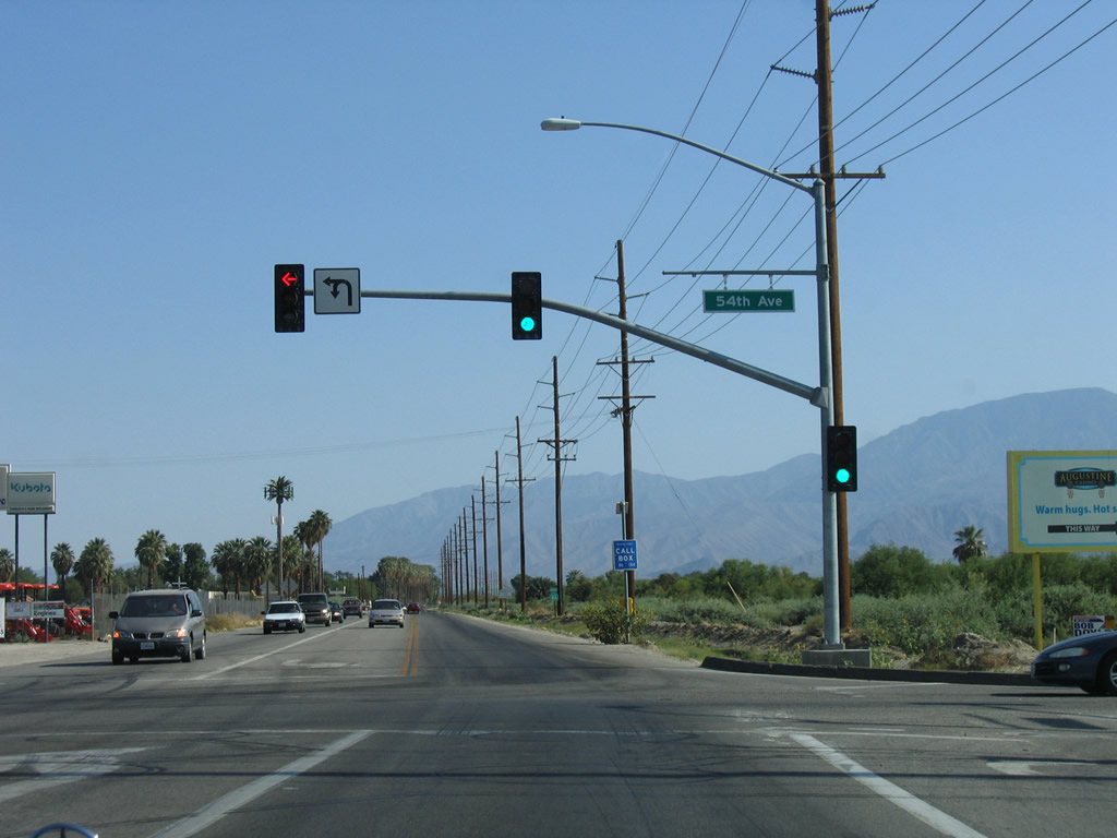
Southbound California 86 approaches 54th Avenue at this traffic signal. Farmland dominates in all directions. Photo taken 05/07/06. |
|
A California 86 south reassurance shield used to be posted along southbound Harrison Street after 54th Avenue; this sign is now gone (and California 86 is rerouted onto the expressway alignment east of here). Photo taken 05/07/06. |
|
Palm trees line the west side of former California 86 (Harrison Street) south of 55th Avenue. Photo taken 05/07/06. |
|
Southbound Harrison Street approaches Airport Boulevard. Turn east on Airport Boulevard to Jacqueline Cochran Regional Airport. Photo taken 05/07/06. |
|
Continuing south through agricultural lands of the southern Coachella Valley, Harrison Street approaches 62nd Avenue. Photo taken 05/07/06. |
|
Southbound Harrison Street approaches 66th Avenue, which travels east to connect to Torres-Martinez Indian Reservation, California 86 expressway, California 111, and Mecca. The portion of 66th Avenue between California 86 and California 111 was signed as California 195 as of January 2013. Photo taken 05/07/06. |
|
Nearing 70th Avenue, former California 86 (Harrison Street) passes by another palm orchard. Photo taken 05/07/06. |
|
More agricultural fields line Harrison Street in this view just north of 72nd Avenue. Photo taken 05/07/06. |
|
An odd approach sign is posted along southbound Harrison Street prior to 74th Avenue. Photo taken 05/07/06. |
|
More palms line Harrison Street near 76th Avenue. Photo taken 05/07/06. |
|
Southbound Harrison Street approaches former California 195 (Pierce Street). By the time we arrived to take a picture of the western end of California 195, the guide signs had already been altered by covering up the route numbers, and all reassurance shields along California 195 itself were gone. Photo taken 05/07/06. |
|
A second altered guide sign points the way from southbound Harrison Street to former California 195 (Pierce Street). The former state highway used to travel north on Pierce Street and east on 66th Avenue. The section of 66th Avenue between California 86 expressway and California 111 remained a signed state highway as late as January 2013. Photo taken 05/07/06. |
| California 78 east & 86 south |
|
Skipping ahead into Imperial County and now southeast of the city of Westmorland, this reassurance shield for California 86 south and California 78 east (Historic U.S. 99 south) is posted after the intersection with Baughman Way. Photo taken 04/20/13. |
|
What appears to be water on the roadway ahead is actually a mirage. Photo taken 04/20/13. |
|
Southbound California 86 and eastbound California 78 approach an intersection with Andre Road. Photo taken 04/20/13. |
|
The 86-78 expressway crosses over the Trifolium Canal. Photo taken 04/20/13. |
|
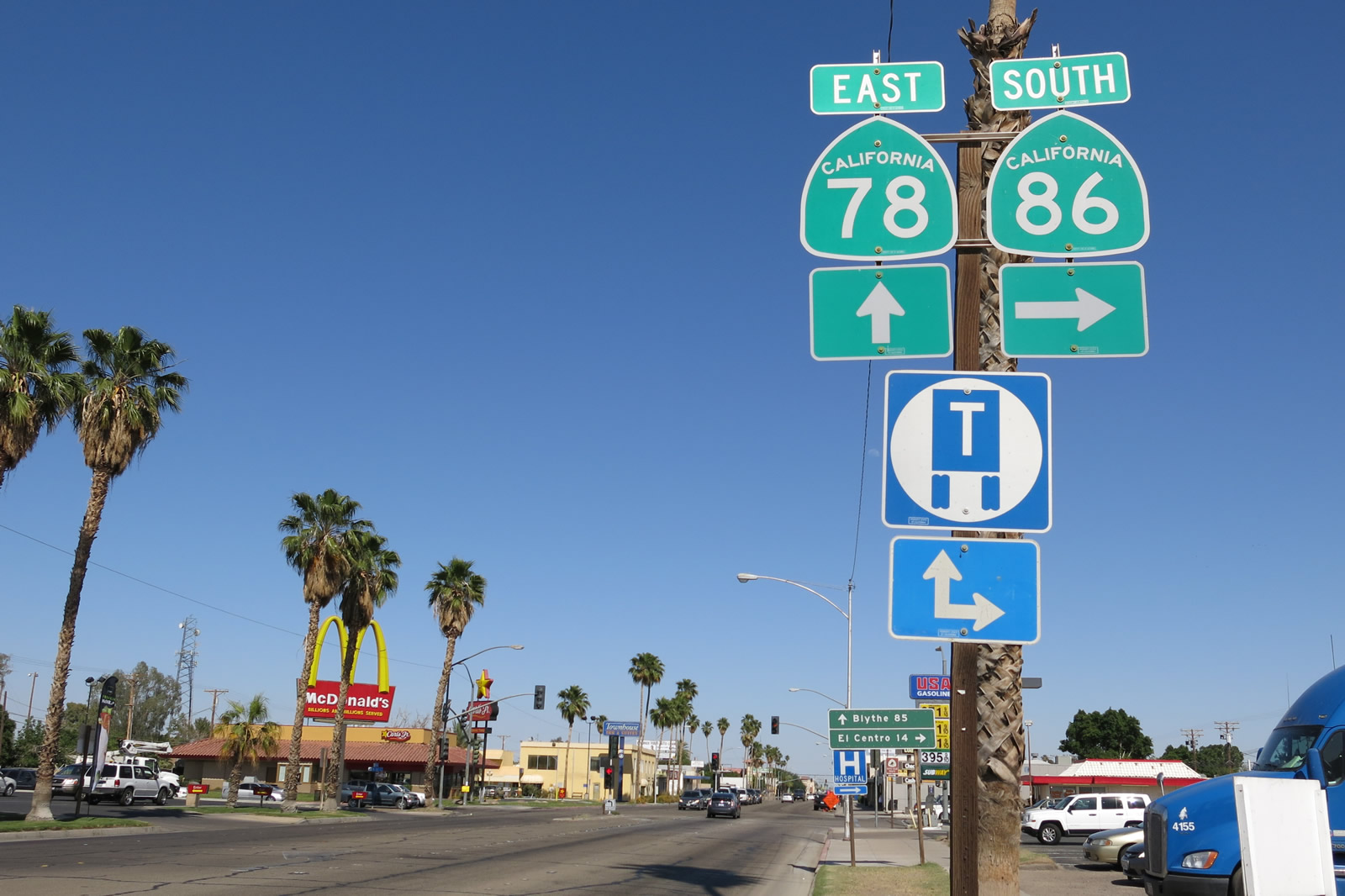
California 86 south and California 78 east divide at the intersection with Fredricks Road. On October 30, 2012, the Brawley Bypass opened in its entirety, and at that time, California 78 was rerouted onto the bypass and removed from downtown Brawley. No business route alignment for California 78 has been designated through Brawley, although one could drive straight ahead through Brawley and eventually reconnect with the California 78-111 bypass on the eastern side of town.Photo taken 04/20/13. |
|
Through traffic on California 78 east, or traffic connecting to California 111 north to Calipatria or south to Calexico, should prepare to turn left at the next traffic signal. The dynamics of the forthcoming intersection will likely change once the Westmorland bypass is constructed. Fredricks Road provides local farm/ranch access. Photo taken 04/20/13. |
|
|
Two lanes will carry California 78 east onto the Brawley Bypass. The right two lanes continue southeast into Brawley via California 86 and Historic U.S. 99 south. Photos taken 04/20/13. |
| California 86 south |
|
Skipping ahead and after crossing the New River, California 86 enters the urbanized area of western Brawley and passes two traffic signals (Rio Vista Avenue and Western Avenue). This view looks east on Main Street after the Western Avenue intersection and prior to the First Street intersection. A series of guide signs are posted to advise of the continuation of California 86 and the now-obsolete California 78 trailblazer. Photo taken 04/20/13. |
|
Eastbound Main Street approaches the intersection with First Street. Turn right for the continuation of California 86 (Historic U.S. 99) south to El Centro. Proceed ahead on Main Street to California 78 east to Blythe. Photo taken 04/20/13. |
|
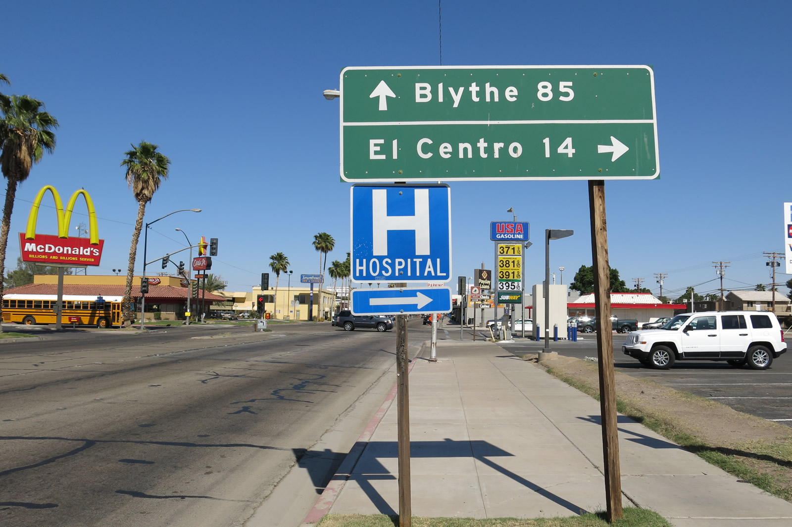
This mileage sign along Main Street eastbound provides the distance to El Centro (14 miles via California 86 south) and Blythe (85 miles via Cailfornia 78 east). Photo taken 04/20/13. |
|
Turn right (south) on First Street to continue along the Juan Bautista de Anza National Historic Trail auto tour route. This sign-posted route generally follows the historic journey made by de Anza in 1775 and 1776 to establish a new, secure route from Sonora, Mexico northwest to Alta California. The auto tour begins in Nogales, Arizona, and extends generally northwest toward the San Francisco Bay Area. Photo taken 04/20/13. |
|
Eastbound Main Street meets First Street at this traffic signal in Brawley. Continue ahead on Main Street to downtown Brawley, or turn right here for California 86 south to El Centro. Photo taken 04/20/13. |
|
Leaving the Main Street (former California 78) intersection in western Brawley, southbound California 86 (First Street) proceeds toward El Centro. Photo taken 04/20/13. |
| Business Loop I-8 east, California 86 south & Imperial County S-80 east |
|
This view looks east on Adams Avenue after the Imperial Avenue intersection in El Centro. Photo taken 04/20/13. |
|
|
After the Imperial Avenue intersection, Adams Avenue gains two more designations in addition to Imperial County S-80: California 86 south and Business Loop I-8 east. The three routes will share alignment until the Main Street intersection, where S-80 will turn off Adams Avenue/Fourth Street and resume its journey east toward Holtville via Evan Hewes Highway. Only California 86 and S-80 are signed here. Photos taken 10/14/06 and 04/20/13. |
|
A modestly landscaped median follows Adams Avenue as it travels east through El Centro. The median sign in the opposite direction was placed in June 1999 according to a date stamp visible along eastbound Adams Avenue. Photo taken 10/14/06. |
|
Adams Avenue remains a very busy road through El Centro. Photo taken 04/20/13. |
|
Nearing Wilson Street, we see street lights lining the road. A power line connects the lights, meaning the electricity to the street lights is strung above the lights rather than placed in conduit underground. Photo taken 10/14/06. |
|
Southbound California 86 and eastbound S-80 and Business Loop 8 meet Tenth Street. Photo taken 04/20/13. |
|
An old, faded marquee sign remains deteriorated in place along Adams Avenue prior to Eighth Street. Photo taken 04/20/13. |
|
|
A California 86 south and Business Loop I-8 east reassurance shield assembly is posted along eastbound Adams Avenue at the signalized intersection with Eighth Street in El Centro. Omitted here is Imperial County S-80. Photos taken 10/14/06 and 04/20/13. |
|
Eastbound Adams Avenue approaches Seventh Street. On the south side of Adams Avenue for the next three blocks is Adams Park, with its green turf visible from Adams Avenue. A restroom is located on the east side of Sixth Street between Adams Avenue and Park Avenue. Photo taken 10/14/06. |
|
Southbound California 86 and eastbound Business Loop I-8 and Imperial County S-80 (Adams Avenue) meet Sixth Street at this signalized intersection. Photo taken 10/14/06. |
|
At Fifth Street, eastbound Adams Avenue begins to turn south onto Fourth Street. A gradual curve allows the highway to turn 90 degrees, partially cutting through Adams Park along the way. Photo taken 10/14/06. |
|
Adams Avenue eastbound curves into Fourth Street southbound. S-80, Business 8, and California 86 all turn south onto Fourth Street. The three routes will remain combined for another four blocks until the Main Street signalized intersection. Photo taken 10/14/06. |
|
At Commercial Avenue, a quick look to the east shows two Southern Pacific Railroad locomotives, which appear not to be in service. Southern Pacific was merged into the Union Pacific Railroad in 1996, just ten years prior to the date on which this picture was taken. Photo taken 10/14/06. |
|
Due to the mid-fall lighting conditions, shadows dominated the view as we turn from eastbound to southbound. Photo taken 10/14/06. |
|
Southbound Fourth Street meets Broadway Street and sees another route marker, this time solely for California 86. At the next intersection (Main Street), the signed routes will divide. Photo taken 10/14/06. |
|
Now approaching Main Street, southbound California 86 and Business Loop I-8 will separate from Imperial County S-80. Turn left on Main Street for Imperial County S-80 east to Holtville (ten miles). Turn right on Main Street for Historic U.S. 80 west (original alignment before "bypass" was built on Adams Avenue) into downtown El Centro. Photo taken 04/20/13. |
|
A series of route markers are posted on southbound Fourth Street just prior to the Main Street intersection. S-80, Business Loop I-8, and California 86 are all posted here. To Interstate 8, continue south on Fourth Street. Photo taken 04/20/13. |
| Business Loop I-8 east & California 86 south |
|
Southbound California 86, Historic U.S. 99, and Business Loop I-8 proceed along Fourth Street after the interscetion with Main Street in El Centro. Businesses line both sides of the busy state route. It is a bit more than a mile from here to the Interstate 8 interchange. Photo taken 04/20/13. |
|
Both California 86 and Business Loop I-8 are fairly well signed along Fourth Street. Photo taken 04/20/13. |
|
Passing by Sandalwood Drive and approaching Ross Avenue on southbound California 86 and Business Loop I-8 (Fourth Street), we find this one-half mile advance sign for the pending junction with Interstate 8 in El Centro. Photo taken 04/20/13. |
|
Southbound California 86 and Business Loop I-8 (Fourth Street) meets the on-ramp to Interstate 8 west to San Diego. The next left connects to Interstate 8 east to Yuma, Tucson, and Phoenix. Photo taken 04/20/13. |
t
|
After passing under the Interstate 8 freeway overpass, southbound California 86 and Business Loop I-8 (Fourth Street) meets the on-ramp to Interstate 8 east to Yuma. Business Loop I-8 ends at this point, although there is no end shield posted here. Photo taken 04/20/13. |
| California 86 south |
|
A California 86 south reassurance shield is posted soon after the interchange with Interstate 8. Photo taken 04/20/13. |
Page Updated March 13, 2013.