

California 78 East - Ogilby Road to Blythe
| California 78 east | |
|---|---|
 |
This view looks east on California 78 after the intersection with Imperial County S-34 (Ogilby Road). Ahead, California 78 will turn north-northeast to pass through the Chocolate Mountains. Photo taken 06/28/08. |
 |
Eastbound California 78 (Ben Hulse Highway) approaches Imperial Gables and Black Mountain Roads. Photo taken 04/01/06. |
 |
At a point where power lines cross the highway, eastbound California 78 approaches a U.S. Border Patrol Inspection Station. This is one of several such stations that create an arc around Imperial County (with other stations located on California 111 north of Niland, California 86 near the California 78 west split, Interstate 8 westbound near Pine Valley, and Interstate 8 eastbound after Yuma). Photo taken 04/01/06. |
 |
 |
 |
 |
 |
| California 78 (Ben Hulse Highway) proceeds through the rolling hills of the southern Chocolate Mountains. The state route follows the undulations of the landscape. A mileage sign provides the distance to Palo Verde (23 miles) and Blythe (43 miles). Photos taken 06/28/08 and 04/01/06. | ||||
 |
 |
 |
 |
 |
| The highway sees several dips/valleys, each with a concrete lip at the bottom of the valley. These concrete lips allow water to flow over the highway when summer monsoon thunderstorms bring copious rain and floodwaters through narrow canyons. Rather than build bridges over these washes, the highway is built to flood. These crossings are known as "Arizona crossings" due to their common appearance on rural, desert highways. Photos taken 06/28/08. | ||||
 |
 |
 |
 |
 |
| California 78 approaches Midway Well Road, which travels west along the northern edge of the Chocolate Mountains. Ahead, California 78 will flatten out for a bit and head toward the Palo Verde Mountains, which rise in the distance. Another mileage sign is posted along this stretch with the same two control cities: Palo Verde (13 miles) and Blythe (33 miles). Photos taken 06/28/08. | ||||
 |
 |
 |
 |
 |
| Approaching the Palo Verde Mountains, California 78 will curve northeast and then north to bypass the mountains and proceed closer to the Colorado River. A right turn connects to Three Slashes Road and Mitchells Camp Road. Photos taken 06/28/08. | ||||
 |
 |
 |
 |
 |
| A green, comparably fertile valley comes into view as California 78 approaches and runs parallel to the Colorado River. Photos taken 06/28/08 and 04/01/06. | ||||
 |
 |
 |
 |
 |
| Turning north California 78 continues toward Palo Verde. Agriculture, not seen since the route passed the Highline Canal in the Imperial Valley, is again found alongside California 78 northward through the Colorado River Valley. River access is available at certain locations, such as the Cibola National Wildlife Refuge. Photos taken 06/28/08 and 04/01/06. | ||||
 |
 |
 |
 |
 |
| An irrigation canal comes alongside California 78 to carry water to the various farm and ranch interests in the Colorado River Valley. Toward the end of this series, California 78 enters Palo Verde, an unincorporated community of Imperial County. The first intersection in Palo Verde is with Clark Way. Photos taken 06/28/08. | ||||
 |
Some services line California 78 as it passes through Palo Verde. Full motorist services are available further north in Blythe. Photo taken 06/28/08. |
 |
At the north end of the community of Palo Verde, California 78 leaves Imperial County and enters Riverside County. Photo taken 06/28/08. |
 |
This mileage sign along California 78 north provides the distance to Ripley (11 miles) and Blythe (20 miles). Photo taken 06/28/08. |
 |
California 78 proceeds through more farmland between Palo Verde and Ripley. Photo taken 06/28/08. |
 |
A California 78 east reassurance shield is posted soon thereafter. Photo taken 06/28/08. |
 |
Watch for a sharp, 15-mile-per-hour turn along California 78 north of Palo Verde. Photo taken 06/28/08. |
 |
A California 78 trailblazer, three-mile postmile marker, and truck route end sign are all posted just prior to the sharp, 90-degree turn. Photo taken 06/28/08. |
 |
California 78 only travels a short distance east on 32nd Avenue before turning north again at another sharp, 90-degree turn (this time to the left). Photo taken 04/01/06. |
 |
California 78 again proceeds due north through farmland, this time on Rannells Boulevard. Photo taken 06/28/08. |
 |
At this stop sign, California 78 turns from Rannells Boulevard onto eastbound 28th Avenue. Photo taken 04/01/06. |
 |
Another California 78 reassurance shield is posted along eastbound 28th Avenue after the turn from Rannells Boulevard. Photo taken 04/01/06. |
 |
Agriculture lines both sides of California 78. A large stack of hay bales comes into view on the south side of 28th Avenue. Photo taken 04/01/06. |
 |
Eastbound California 78 (28th Avenue) passes over an irrigation canal. Photo taken 04/01/06. |
 |
The highway continues flat and even as it approaches another sharp turn. Photo taken 04/01/06. |
 |
California 78 only travels east for a short distance and again turns north, this time on Neighbours Boulevard. Photo taken 04/01/06. |
 |
A mileage sign for Ripley (one mile) and Blythe (ten miles) is posted along California 78 prior to the turn from eastbound 28th Avenue onto northbound Neighbours Boulevard. Photo taken 04/01/06. |
 |
This view looks north along California 78 (Neighbours Boulevard) toward the unincorporated community of Ripley. Photo taken 06/28/08. |
 |
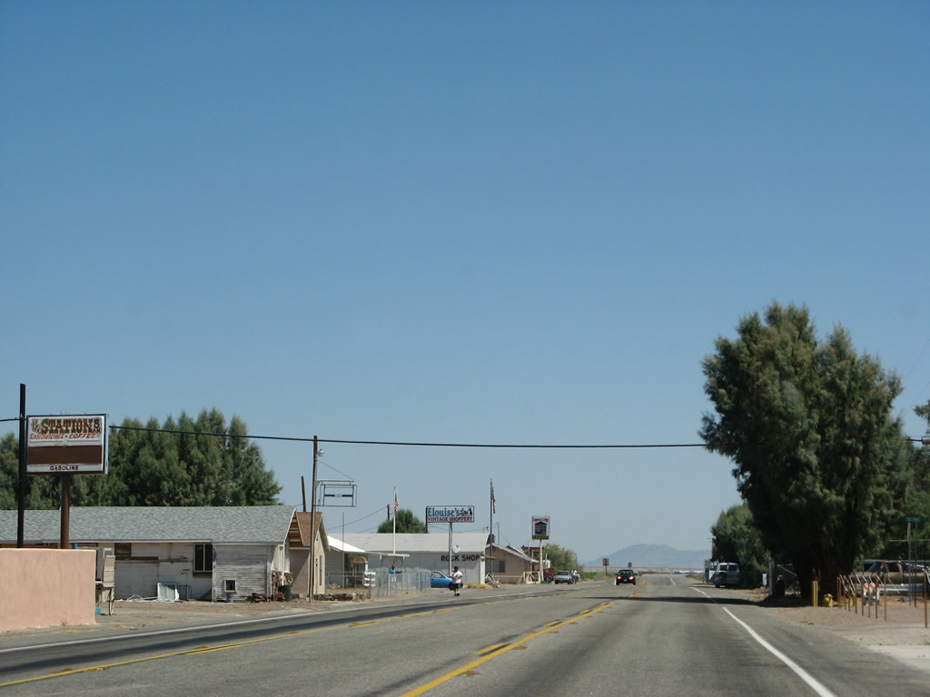
California 78 (Neighbours Boulevard) enters the unincorporated community of Ripley, which had a population of 692 per the 2010 Census. Photo taken 04/01/06. |
 |
Some businesses line California 78 (Neighbours Boulevard) in Ripley, but a more complete group of services may be found in Blythe, which is just north of here. Photo taken 06/28/08. |
 |
 |
 |
 |
 |
| Leaving Ripley, California 78 (Neighbours Boulevard) approaches a 500kV Southern California Edison power line, which crosses over nearby farmland. This line connects between power generating facilities in Arizona and a substation near Palm Springs. A mileage sign provides the distance to the Interstate 10 junction as well as Blythe. Photos taken 06/28/08. | ||||
 |
Northbound California 78 (Neighbours Boulevard) approaches 20th Avenue. Photo taken 06/28/08. |
 |
Tall power lines follow California 78 (Neighbours Boulevard) between 18th Avenue and Seeley Avenue. Farmland dominates on both sides of the state route. Photo taken 06/28/08. |
 |
Northbound California 78 (Neighbours Boulevard) approaches Seeley Avenue. We are very close to Interstate 10 now. Photo taken 06/28/08. |
 |
Eastbound California 78 approaches Interstate 10 in Blythe. The junction sign was missing by 2006. Photo taken 04/01/06. |
 |
Northbound California 78 (Neighbours Boulevard) meets the turnoff to Interstate 10 east to Blythe, Quartzsite, and Phoenix. Interstate 10 crosses the Colorado River between Blythe and Ehrenberg. Photo taken 04/01/06. |
| Business Loop I-10 & California 78 east | |
|---|---|
 |
After the ramp to Interstate 10 east to Phoenix, California 78 crosses over the Interstate 10 freeway and approaches the left turn to Interstate 10 west to Indio, San Bernardino, and Los Angeles. This is also the beginning of Business Loop I-10 east. Photo taken 03/14/09. |
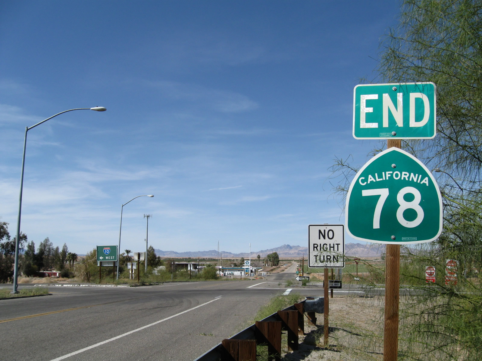 |
An end California 78 shield assembly is posted at the interchange with Interstate 10. Continue straight ahead to cross Interstate 10 and join Business Loop I-10 (former U.S. 60-70) east toward Downtown Blythe. Photo taken 03/14/09. |
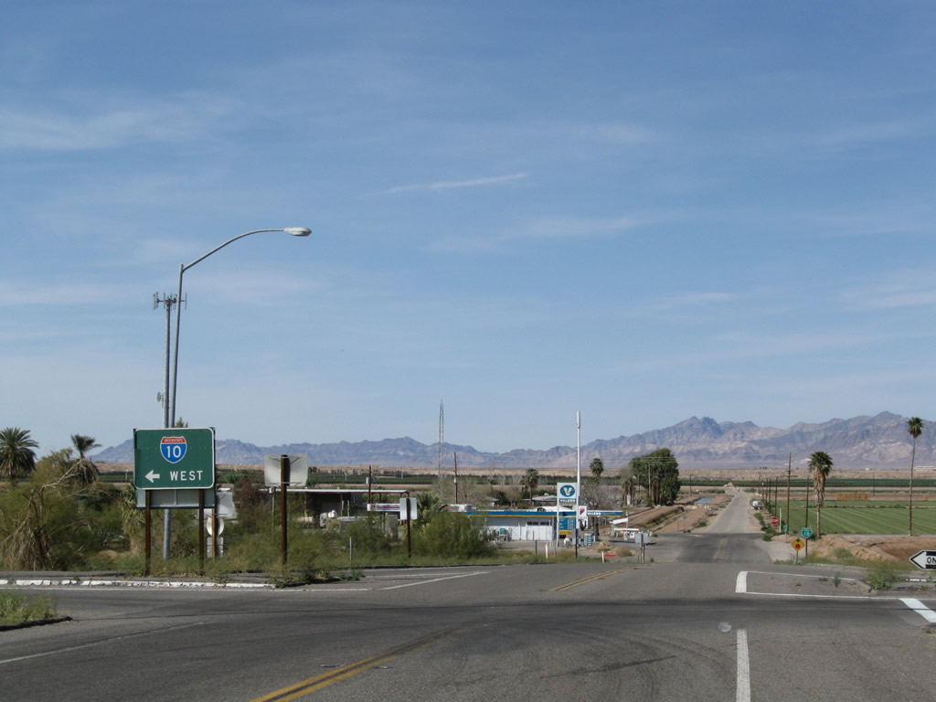 |
After the end shield, turn left here to Interstate 10 west to Indio, San Bernardino, and Los Angeles. Business Loop I-10 continues north to Hobsonway, where it turns east to follow Old U.S. 60-70 toward Downtown Blythe. Photo taken 03/14/09. |


Page Updated March 10, 2013.
|
About Contact Glossary |
In The News Testimonials Interstate Guide |
Social Media:
 |
|
© 2000-23 AARoads.com | All Rights Reserved | Privacy Policy / Terms of Use
|
||