| California 73 south |
|
After departing from Interstate 405, this trailblazer points the way south on California 73 toll road as an alternate route south to San Juan Capistrano and Interstate 5 to San Diego. California 73 begins in the city of Costa Mesa, which had a population of 108,724 as of 2000 Census and sits at an elevation 98 feet. Costa Mesa incorporated on June 29, 1953). Photo taken 07/12/04. |
|
Southbound California 73 reaches Exit 17B, Bear Street. The next exit is Exit 17A, California 55 south (there is no access to California 55 north). Photo taken 07/12/04. |
|
Another trailblazer after the Bear Street interchange points the way south on California 73 toll road as an alternate route south to San Juan Capistrano and Interstate 5 to San Diego. Photo taken 07/12/04. |
|
The next exit along California 73 (Corona del Mar Freeway) south is Exit 17A, California 55 (Costa Mesa Freeway) south to Costa Mesa and Newport Beach. The toll road does not begin for another 3.25 miles. The right two lanes exit onto California 55. Photo taken 07/12/04. |
|
Southbound California 73 reaches Exit 17A, California 55 (Costa Mesa Freeway) south. Photo taken 07/12/04. |
|
The next exit along California 73 (Corona del Mar Freeway) south is Exit 16, Irvine Avenue and Campus Drive. Photo taken 01/30/05. |
|
This mileage sign along California 73 (Corona del Mar Freeway) south provides the distance to the next two exits: Exit 16, Irvine Avenue and Campus Drive and Exit 15, Jamboree Road. Photo taken 01/30/05. |
|
The next exit along California 73 (Corona del Mar Freeway) south is Exit 16, Irvine Avenue and Campus Drive. The next exit is for Jamboree Road (Exit 15). Photo taken 07/27/02. |
|
Southbound California 73 (Corona del Mar Freeway) meets Exit 16, Irvine Avenue and Campus Drive. Photo taken 01/30/05. |
|
The next exit along California 73 (Corona del Mar Freeway) south is Exit 15, Jamboree Road. Traveling north from here, Jamboree Road passes through Irvine, transitioning directly onto California 261 north. Photo taken 01/30/05. |
|
|
Southbound California 73 (Corona del Mar Freeway) approaches Exit 15, Jamboree Road. An overhead sign present in 2002 was gone in 2005 presumably due to the additional auxiliary exit lane for the Jamboree Road off-ramp. At this point, California 73 leaves Costa Mesa and enters the city of Newport Beach (population 70,032 as of 2000 Census and incorporated September 1, 1906). Photos taken 01/30/05 and 07/27/02. |
|
Southbound California 73 (Corona del Mar Freeway) reaches Exit 15, Jamboree Road. Photo taken 01/30/05. |
|
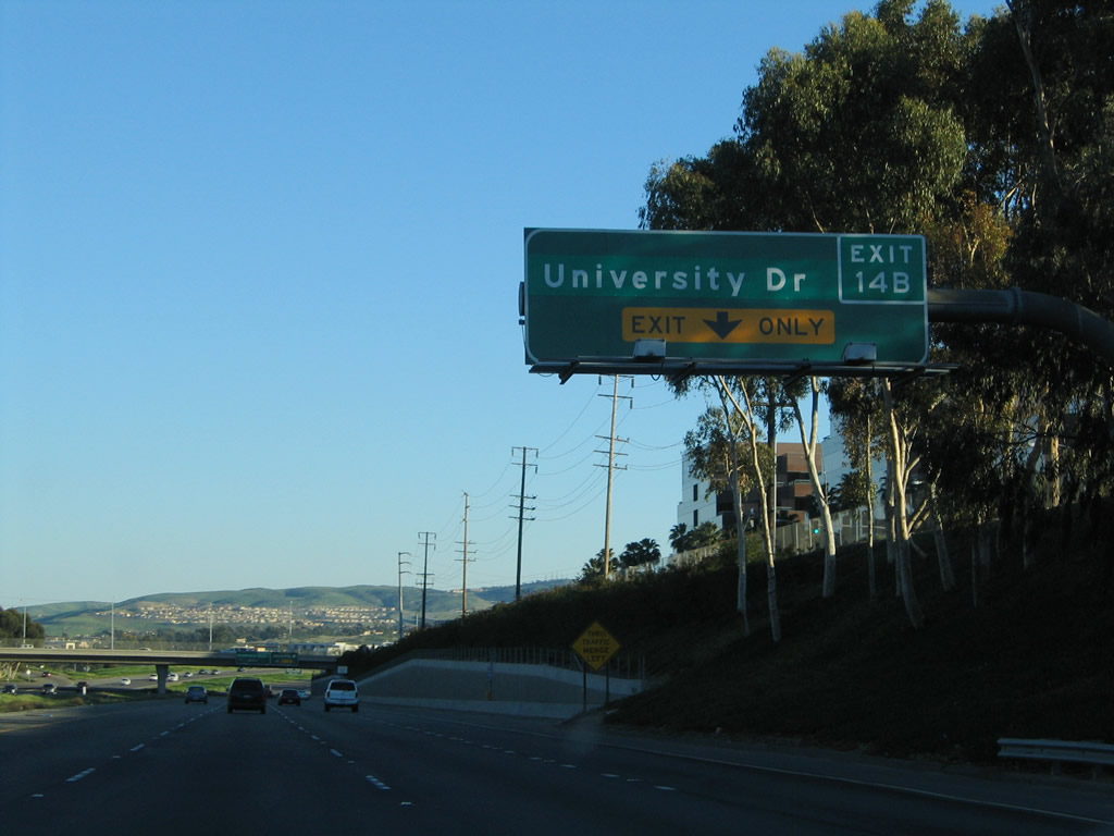
This mileage sign provides the distance to the next three exits along California 73 (Corona del Mar Freeway) south: Exit 14B, University Drive; Exit 14A, MacArthur Boulevard; and Exit 13, Bison Avenue. University Drive eastbound leads to the University of California at Irvine. The university sits snugly between University Avenue and the toll road. The last exit before toll is Exit 13, Bison Avenue. Photo taken 01/30/05. |
|
The right lane becomes exit only for Exit 14B to University Drive, which connects to the University of California at Irvine. Photo taken 01/30/05. |
|
|
Southbound California 73 reaches Exit 14B, University Drive. The next exits along southbound are MacArthur Drive and Bison Avenue, the last exits before the toll road begins. Photos taken 01/30/05 and 07/27/02. |
|
The next exit along California 73 (Corona del Mar Freeway) south is Exit 14A, MacArthur Drive. Use this exit to Corona del Mar and Newport Center, both of which are communities within the city of Newport Beach. Photo taken 01/30/05. |
|
This mileage sign along California 73 (Corona del Mar Freeway) south provides the distance to the next three exits: Exit 14A, MacArthur Drive; Exit 13, Bison Avenue; and Exit 12, Bonita Canyon Road. Prior to the completion of the San Joaquin Hills Transportation Corridor in 1996, this was the last southbound freeway exits for nearly 20 years. California 73 used to depart the freeway here and travel south on MacArthur Boulevard to meet California 1 (Pacific Coast Highway) in Newport Beach. Once the toll road was completed, California 73 was removed from MacArthur Boulevard, and the former state highway reverted to a city street. Photo taken 01/30/05. |
|
The right lane of California 73 (Corona del Mar Freeway) south becomes exit only for Exit 14A, MacArthur Drive. Photo taken 01/30/05. |
|
Southbound California 73 reaches Exit 14A, MacArthur Drive. This is the last exit before the toll road begins, although motorists have one more chance to exit (at Exit 13, Bison Avenue) before being charged a toll. Photo taken 01/30/05. |
| California 73 - San Joaquin Hills Transportation Corridor south |
|
Southbound California 73 meets Exit 13, Bison Avenue, the last exit before toll along southbound. Photo taken 01/30/05. |
|
The next two exits along California 73 (San Joaquin Hills Transportation Corridor) south are Exit 12, Bonita Canyon Road and Exit 11, Newport Coast Road. All through traffic will pay a toll for continuing south on California 73. Photo taken 01/30/05. |
|
As California 73 approaches Exit 12, Bonita Canyon Road, the toll road starts to gain elevation. This rise will continue all the way to the Catalina View Toll Plaza, the only mainline toll plaza on California 73. Photo taken 01/30/05. |
|
Southbound California 73 reaches Exit 12, Bonita Canyon Road. Photo taken 01/30/05. |
|
Traffic exiting to Bonita Canyon Road may use FasTrak or cash to pay the toll, although exact change may be required at many unattended toll booths. Photo taken 01/30/05. |
|
This mileage sign along California 73 south provides the distance to Exit 1, Interstate 5 (San Diego Freeway) and San Juan Capistrano. Photo taken 01/30/05. |
|
A California 73 south reassurance shield is posted after the on-ramp from Bonita Canyon Road. Photo taken 01/30/05. |
|
A second mileage sign along California 73 south provides the distance to Exit 11, Newport Coast Road and the Catalina View Toll Plaza. Photo taken 01/30/05. |
|
Southbound California 73 reaches Exit 11, Newport Coast Road. Photo taken 01/30/05. |
|
This mileage sign along California 73 (San Joaquin Hills Transportation Corridor) south provides the distance to the Catalina View Toll Plaza and Exit 7, California 133 (Laguna Canyon Road) and Orange County S-18 (El Toro Road). Photo taken 01/30/05. |
|
|
|
Reaching the top of the grade, California 73 (San Joaquin Hills Transportation Corridor) south approaches the Catalina View Toll Plaza. Stay left for FasTrak or right for cash/attended toll booths. This series of pictures takes us through the FasTrak lanes; an incredible view looking through the San Joaquin Hills toward the distant foothills comes into view after the toll plaza. Photos taken 01/30/05. |
|
|
|
|
The next exit from California 73 south is Exit 7, California 133 (Laguna Canyon Road) and Orange County S-18 (El Toro Road). An off-ramp departs the toll road and splits with the first connection to California 133 and the second connection to El Toro Road. Photo taken 01/30/05. |
|
Use Exit 7 to Laguna Beach and Laguna Woods. Photo taken 01/30/05. |
|
California 133 (Laguna Canyon Road) travels southwest to the city of Laguna Beach or northeast to Interstate 405, Interstate 5, and California 241. The last segment between Interstate 5 and California 241 is a toll road (part of the Eastern Transportation Corridor). This interchange also connects to Orange County S-18 (El Toro Road). The highway was upgraded to expressway standards in stages between 2004 and 2008. Photo taken 01/30/05. |
|
Southbound California 73 meets Exit 7, California 133 (Laguna Canyon Road) to Orange County S-18 (El Toro Road). Photo taken 01/30/05. |
|
This view shows the signage posted for California 133 along the collector distributor lanes along southbound. Photo taken 01/30/05. |
|
This sign for California 133 along the collector distributor lanes along southbound is incorrect, as California 133 is not a freeway this far south. California 133 becomes an expressway and ultimately freeway as it heads north toward Interstate 405, and ultimately it is a toll road before ending at California 241. Although plans have called for California 133 to be a freeway from Interstate 405 south to California 1, those plans have never come to fruition and likely never will. Photo taken 01/30/05. |
|
Skipping ahead past Exit 5, which connects California 73 south with Pacific Park Drive and Glenwood Drive, the following exit along California 73 (San Joaquin Hills Transportation Corridor) south is Exit 4, Aliso Creek Road (0.50 mile). Photo taken 01/30/05. |
|
This view looks southeast along California 73 prior to Exit 4, Aliso Creek Road. Photo taken 01/30/05. |
|
Southbound California 73 reaches Exit 4, Aliso Creek Road, one mile. Photo taken 01/30/05. |
|
California 73 passes through the city of Aliso Viejo between El Toro Road (Exits 6-7) and La Paz Road (Exit 4). Aliso Viejo had a population of 40,166 as of the 2000 Census and was incorporated on July 1, 2001. Photo taken 01/30/05. |
|
The next exit along California 73 (San Joaquin Hills Transportation Corridor) south is Exit 3, La Paz Road and Moulton Parkway (one-half mile). The mileage sign lists Moulton Parkway and Greenfield Drive as subsequent exits, but Moulton Parkway is really accessed via Exit 3. Note the non-reflective overlay used on the mileage for Moulton Parkway. Photo taken 01/30/05. |
|
The right two lanes of California 73 south will connect to Exit 3, La Paz Road and Moulton Parkway. Photo taken 01/30/05. |
|
Southbound California 73 reaches Exit 3, La Paz Road/Moulton Parkway. Photo taken 01/30/05. |
|
This picture looks at the overhead guide signs for La Paz Road and Moulton Parkway on the collector distributor lanes for Exit 3. Photo taken 01/30/05. |
|
|
The southbound collector distributor lanes meet the off-ramp to Moulton Parkway within the Exit 3 interchange complex. Toll booths await for traffic joining the toll road. After Moulton Parkway, California 73 serves as the boundary between Laguna Niguel to the southwest and Laguna Hills to the northeast. Laguna Hills was home to 31,178 people as of the 2000 Census and is located north of Laguna Niguel, east of Mission Viejo, west of Laguna Woods, and south of Lake Forest. Laguna Niguel had a population 61,891 as of 2000 Census and was incorporated on December 1, 1989. Photos taken 01/30/05. |
|
This mileage sign provides the distance to final two exits along California 73 (San Joaquin Hills Transportation Corridor) south is Exit 2, Greenfield Drive and Exit 1, Interstate 5 (San Diego Freeway) south. Photo taken 01/30/05. |
|
Use Exit 2, Greenfield Drive to the cities of Laguna Niguel and Mission Viejo. Use Greenfield Drive south to Crown Valley Parkway east to Mission Viejo, which on the Interstate 5 corridor. Photo taken 01/30/05. |
|
Southbound California 73 reaches Exit 2, Greenfield Drive. Greenfield Drive connects to Crown Valley Parkway, which is a good route toward the newer communities of eastern Orange County. After this interchange, southbound California 73 prepares to merge onto Interstate 5 (San Diego Freeway) south. Photo taken 07/27/02. |
|
|
|
This series of pictures shows the connection from California 73 south to Interstate 5 south at the north end of San Juan Capistrano. No end shield is present at the southern terminus. Photos taken 01/30/05. |
Page Updated October 7, 2010.