| California 70 east |
|
Leaving California 89 behind, a mileage sign along California 70 (Feather River Highway) provides the distance to Portola (ten miles) and Reno (57 miles). Photo taken 09/04/10. |
|
A California 70 east reassurance shield is posted along Feather River Highway soon thereafter. Photo taken 09/04/10. |
|
California 70 (Feather River Highway) continues east through Plumas National Forest en route to Portola. The highway stays north of the Middle Fork of the Feather River; the river comes back into view near Portola. Photo taken 09/04/10. |
|
Eastbound California 70 (Feather River Highway) approaches Mohawk Vista Drive. Mohawk Vista Drive is an old alignment of California 70; it travels east and parallels California 70 for several miles then rejoins the state route. Photo taken 09/04/10. |
|
A passing lane is ahead in one mile. Photo taken 09/04/10. |
|
Most of the path of state route between Blairsden and Portola is undeveloped as SR 70 proceeds east through the national forest. Photo taken 09/04/10. |
|
The passing lane begins on an upgrade. California 70 has seen gradual elevation increases as it proceeds east from the Sacramento Valley: Oroville sits at an elevation of 170 feet, Quincy sits at an elevation of 2,423 feet, Spring Garden sits at an elevation of 3,986 feet, and Blairsden sits at an elevation of 4,380 feet. Ahead, California 70 will rise to 4,860 feet at Portola, 4,945 feet at Vinton in the Sierra Valley, and ultimately Beckwourth Pass at an elevation of 5,228 feet before descending to Hallelujah Junction (interchange with U.S. 395). The highest elevation is significantly lower than those seen on Interstate 80 (Donner Summit - 7,227 feet), U.S. 50 (Echo Summit - 7,382 feet), and California 88 (Carson Pass - 8,650 feet). Photo taken 09/04/10. |
|
California 70 (Feather River Highway) next approaches its intersection with C Road. Photo taken 09/04/10. |
|
A bit further east, California 70 approaches Sierra Springs Drive. Photo taken 09/04/10. |
|
California 70 leaves Plumas National Forest. Photo taken 09/04/10. |
|
A California 70 east reassurance shield is posted soon thereafter along Feather River Highway. Photo taken 09/04/10. |
|
Even though the state route has left the national forest, camping activities are available near California 70. Photo taken 09/04/10. |
|
California 70 continues straight as an arrow east. Photo taken 09/04/10. |
|
Eastbound California 70 (Feather River Highway) next approaches its intersection with Clio State 40A Road, which is Old California 24 and U.S. 40 Alternate. Turn right here to follow Clio State 40A Road southwest to connect with California 89 in Clio. Notable along this stretch of old alignment is the Clio Trestle, which is a towering bridge that carries the Union Pacific Railroad over the old road and Willow Creek. Photo taken 09/04/10. |
|
California 70 (Feather River Highway) meets Clio State 40A Road at this intersection. Ahead, California 70 proceeds east toward Delleker and Portola. Photo taken 09/04/10. |
|
After the Clio State 40A Road intersection, California 70 (Feather River Highway) continues east with a sweeping vista en route to Delleker. Photo taken 09/04/10. |
|
California 70 enters the unincorporated community of Delleker. Photo taken 09/04/10. |
|
Westbound California 70 approaches Delleker Park Drive (next left). Photo taken 09/04/10. |
|
California 70 crosses Humbug Creek. Photo taken 09/04/10. |
|
Westbound California 70 approaches Delleker Road (next left). Photo taken 09/04/10. |
|
Only a short distance separates Delleker from the city of Portola. Photo taken 09/04/10. |
|
A tourist attraction in Portola is the Western Pacific Railroad Museum (formerly known as the Portola Railroad Museum until January 2006). A variety of railroad artifacts and historical equipment can be viewed at the museum, which also offers a base for taking trips around Plumas County to see the various railroad improvements along the Feather River (such as Clio Trestle, Williams Loop, and the canyon bridges). Photo taken 09/04/10. |
|
California 70 enters the city of Portola, the only incorporated city in Plumas County. The county seat of Quincy is not currently incorporated. Portola ("The Pride of the West") had a population of 2,104 as of the 2010 Census. Photo taken 09/04/10. |
|
The railroad museum is visible to the south of the state route. Photo taken 09/04/10. |
|
A welcome monument sign for the city of Portola is posted along eastbound California 70. Photo taken 09/04/10. |
|
California 70 proceeds into Portola. Photo taken 09/04/10. |
|
The first major intersection in Portola connects California 70 with West Street, which becomes Lake Davis Road and travels north to the unincorporated community of Lake Davis and a reservoir of the same name. Lake Davis made headlines when an effort was made to poison the reservoir to eradicate an invasive fish, the northern pike, in September 2007. Photo taken 09/04/10. |
|
California 70 becomes known as Sierra Street within the city limits of Portola. The highway widens to five lanes with two lanes in each direction and a center turn lane. Photo taken 09/04/10. |
|
The next major intersection along California 70 (Sierra Street) east is Plumas County A-15 (Gulling Street). Take Gulling Street south to the post office, railroad museum, hospital, and additional services. South of the city limits, A-15 proceeds southwest along Portola McLears Road to connect with California 89 southeast of Clio near Whitehawk. This intersection serves as the northern terminus of A-15. Photo taken 09/04/10. |
|
Eastbound California 70 meets Plumas County A-15 (Gulling Street) at this traffic signal in downtown Portola. Photo taken 09/04/10. |
|
California 70 proceeds east through the Portola business district after the Plumas County A-15 (Gulling Street) intersection. Photo taken 09/04/10. |
|
A few more motels are located toward the east end of the city. A tourist information center is located ahead on the right. Photo taken 09/04/10. |
|
|
Next to the tourist information center is this California 70 route marker assembly, complete with scenic byway sign. California 70 continues with the Feather River Highway name all the way to Hallelujah Junction, where California 70 meets U.S. 395. Photos taken 09/04/10. |
|
Leaving Portola, this mileage sign along California 70 east provides the distance to Beckwourth (five miles) and the control city of Reno (48 miles). Photo taken 09/04/10. |
|
Resuming its rural configuration, California 70 sees another set of passing lanes east of Portola. Photo taken 09/04/10. |
|
Eastbound California 70 meets Rocky Point Road. Turn right at this intersection for Rocky Point Road, which is the original alignment of the Feather River Highway and rejoins modern California 70 about a mile or so east of here. Photo taken 09/04/10. |
|
A realigned segment of California 70 bypasses the old alignment along Rocky Point Road and offers a brief, multi-lane highway. Photo taken 09/04/10. |
|
|
|
|
|
| California 70 travels uphill with a passing lane. At the top of the grade is a view looking down onto Rocky Point Road (old California 70), the adjacent river, and railroad. A rest area is located ahead, but it was closed at the time this picture was taken. Photos taken 09/04/10. |
|
California 70 proceeds downhill toward Grizzly Creek and Rocky Point Road. Photo taken 09/04/10. |
|
Eastbound California 70 crosses Grizzly Creek and approaches the eastern end of Rocky Point Road. Photo taken 09/04/10. |
|
California 70 meets Grizzly Road north and Rocky Point Road west. Use Grizzly Road north to Lake Davis. Photo taken 09/04/10. |
|
The next right from California 70 connects to the L.T. Davis Safety Rest Area. Normally this rest area is open, but it was closed on this day due to maintenance upgrades. The L.T. Davis Safety Rest Area normally offers restrooms, water, picnic tables, phone, and disabled access. The rest area has since reopened. Photo taken 09/04/10. |
|
East of the L.T. Davis Safety Rest Area, the scenery changes dramatically. Now entering the Sierra Valley, California 70 will proceed east along the northern edge of the valley toward Beckwourth and Vinton. Photo taken 09/04/10. |
|
Eastbound California 70 (Feather River Highway) approaches Plumas County A-23/Beckwourth Calpine Road, which travels south to Calpine and ultimately connects to California 49/Golden Chain Highway and California 89 near Sattley. Photo taken 09/04/10. |
|
This California 70 reassurance shield is posted after the A-23 intersection. Photo taken 09/04/10. |
|
Looking southeast past the power line is the wide Sierra Valley, which has an approximate elevation of 4,850 feet. Freshwater marshes and wetlands drain into the Middle Fork of the Feather River and travel west toward Lake Oroville. Ranches and farms dot the landscape. Photo taken 09/04/10. |
|
California 70 enters the unincorporated community of Beckwourth (population 432 people as of the 2010 Census). Photo taken 09/04/10. |
|
Toward the center of the community, eastbound California 70 approaches Genesee-Beckwourth Road. Photo taken 09/04/10. |
|
Another California 70 reassurance shield is posted as we leave Beckwourth. Photo taken 09/04/10. |
|
The next left connects California 70 to Nervino Airport. Photo taken 09/04/10. |
|
Eastbound California 70 approaches Plumas County A-24, which travels south and then east to connect with California 49 south en route to Loyalton. Photo taken 09/04/10. |
|
California 70 continues east through the Sierra Valley between Beckwourth and Vinton. Photo taken 09/04/10. |
|
Eastbound California 70 approaches Maddalena Road. Photo taken 09/04/10. |
|
California 70 sees a brief rise in elevation. Photo taken 09/04/10. |
|
This in turn offers a nice view looking southeast across the Sierra Valley on this late summer day. Photo taken 09/04/10. |
|
And then, California 70 descends back to the valley floor just west of Vinton. Photo taken 09/04/10. |
|
Another California 70 reassurance shield is posted soon thereafter. Photo taken 09/04/10. |
|
Eastbound California 70 approaches Dotta Guidici Road. Photo taken 09/04/10. |
|
Entering the unincorporated community of Vinton, eastbound California 70 approaches California 49 - Golden Chain (Mother Lode) Highway south to Loyalton. Photo taken 09/04/10. |
|
The speed limit reduces while passing through the community of Vinton. Photo taken 09/04/10. |
|
Tiny Vinton (along with nearby Chilcoot) had a population of 454 people as of the 2010 Census. Photo taken 09/04/10. |
|
California 49 is the Golden Chain Highway, which travels southwest to Loyalton along the southern edge of the Sierra Valley, then proceeds south to Sierraville. After a brief shared alignment with California 89, southbound California 49 actually travels west through Yuba Pass to Downieville in Sierra County, then proceeds south again through the Sierra Nevada foothills to serve a series of historic Gold Rush-era towns and cities along the famed Mother Lode. Photo taken 09/04/10. |
|
Eastbound California 70 meets California 49 at this intersection. Photo taken 09/04/10. |
|
Another California 70 east reassurance shield is posted shortly after the California 49 intersection in Vinton. Photo taken 09/04/10. |
|
This mileage sign provides the distance to Chilcoot (two miles) and Reno (31 miles) via California 70 east. Photo taken 09/04/10. |
|
For the first time, California 70 reaches an elevation of 5,000 feet. Photo taken 09/04/10. |
|
Now entering Chilcoot, eastbound California 70 approaches California 284 (Frenchman Lake Road) in Chilcoot. California 284 travels north from this intersection to Frenchman Lake but is not a through highway; California 284 ends at the access road to the dam holding back Frenchman Lake. Photo taken 09/04/10. |
|
|
|
Eastbound California 70 meets California 284 (Frenchman Lake Road) in Chilcoot. This is one of only four California 284 shields in existence: one at each end of the highway itself, and one in each direction along California 70 (such as this one). This sign changed slightly between 2003 and 2010. Photos taken 09/04/10 and 01/19/03. |
|
California 70 leaves Chilcoot. Photo taken 09/04/10. |
|
Again climbing uphill, California 70 makes the final climb to Beckwourth Pass. Photo taken 09/04/10. |
|
A passing lane begins as California 70 approaches a turnoff for a historical marker associated with Beckwourth Pass. We now depart Sierra Valley. Photo taken 09/04/10. |
|
Reaching an elevation of 5,221 feet, California 70 finally meets the highest elevation along the Feather River Highway. From here, the highway will descend rather rapidly toward Hallelujah Junction and U.S. 395. Photo taken 09/04/10. |
|
California 70 leaves Plumas County and enters the southernmost extreme of Lassen County (population 34,895 as of 2010 Census) east of Chilcoot. The state route will continue another 3.9 miles through to U.S. 395 at Hallelujah Junction. Photo taken 09/09/05. |
|
|
|
Descending toward Hallelujah Junction from Beckwourth Pass (el. 5,212 feet) on California 70 east. The final reassurance shield lies ahead of the Beckwourth Pass Overhead, an underpass allowing a grade separation between California 70 and an adjacent railroad line. Photos taken 09/04/10. |
|
Eastbound California 70 approaches U.S. 395 at Hallelujah Junction, one-quarter mile. California 70 is shielded as an east-west route through here, as it was through the Feather River Canyon west of Quincy. U.S. 40 Alternate will shift from California 70 east to U.S. 395 south for the final distance to Reno. Between 1954 and 1964, U.S. 40 Alternate followed the Feather River Highway between Oroville and Portola and continued southeast along U.S. 395 to end at U.S. 40 in downtown Reno. Photo taken 09/09/05. |
|
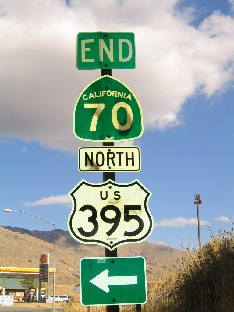
California 70 (Feather River Highway) east ends at its junction with U.S. 395. U.S. 395 travels north to Susanville and south to Bordertown and Reno-Sparks in Nevada. The state scenic route designation ends here as well. A second end sign assembly is posted ahead under the U.S. 395 bridge. Photo taken 09/09/05. |
|
|
Soon thereafter, California 70 enters the diamond interchange with U.S. 395 at Hallelujah Junction. U.S. 395 southbound crosses into Nevada in eight miles and meets Interstate 80 in 22 miles. Photos taken 09/09/05 and 09/04/10. |
|
|
A button copy overhead directs motorists onto U.S. 395 northbound for Susanville. U.S. 395 skirts the eastern reaches of the state 19 miles north to Doyle before turning northwest to Honey Lake and Susanville. The US highway travels a total of 197 miles between California 70 and the Oregon state line north of Alturas. Photos taken 09/09/05. |
|
|
Northbound California 70 concludes at the ramp to northbound U.S. 395 with a second end shield. Larder Way spurs east from the diamond interchange with U.S. 395. Photos taken 09/09/05. |
|
Freeway entrance shield assembly for U.S. 395 north to Susanville. Photo taken 09/04/10. |
Page Updated April 20, 2012.