
California 62 West
| California 62 west | |
|---|---|
 |
From Parker, Arizona, a spur route of Arizona 95 links Arizona 95 with California 62. An end shield is posted for Arizona 95 Spur prior to the Colorado River bridge crossing in Parker. (For some reason at the time this picture was taken, the "SPUR" banner or "95S" designation was missing, seemingly making this look like the end of mainline Arizona 95 even though it is not.) Photo taken 02/20/05. |
 |
A steel through truss bridge carries railroad tracks across the river on a path parallel to the California 62-Arizona 95 Spur bridge. Photo taken 02/20/05. |
 |
At midpoint, the bridge leaves the Grand Canyon State of Arizona and enters the Golden State of California. Photo taken 02/20/05. |
 |
This is the first westbound California 62 shield, immediately after the Colorado River bridge south of Parker Dam after crossing the California-Arizona state line. Photo taken 02/20/05. |
 |
Westbound California 62 passes under the railroad bridge. Photo taken 02/20/05. |
 |
For the majority of its length, California 62 is in San Bernardino County. Photo taken 02/20/05. |
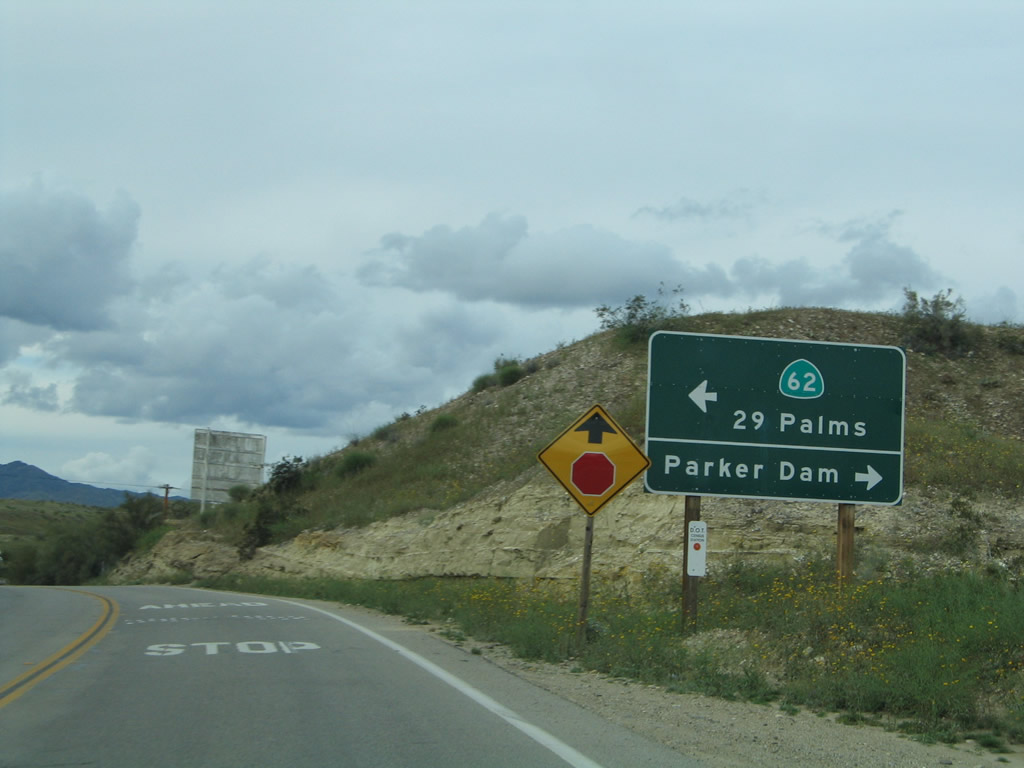 |
At the stop sign ahead, turn left to follow California 62 west to Vidal Junction (U.S. 95 intersection) and Twentynine Palms. Turn right to follow Parker Dam Road northeast to Parker Dam. Photo taken 02/20/05. |
 |
 |
Meeting Parker Dam Road, turn left to follow California 62 west to U.S. 95 or turn right to follow Parker Dam Road to Cross Roads and Parker Dam. Photos taken 02/20/05. |
 |
Some distance after the Parker Dam Road intersection, westbound California 62 meets U.S. 95 at Vidal Junction, then continues west toward Twentynine Palms. Much of the 134-mile distance from Vidal Junction to Interstate 10, especially the 93-mile distance from Vidal Junction to Twentynine Palms, is completely devoid of settlement or services. This lends credence to the above sign located near Twentynine Palms along eastbound California 62. Photo taken 11/13/00. |
 |
This sign provides the mileage to Desert Center and Twentynine Palms. Photo taken 02/25/06. |
 |
Turn right to continue west on California 62 to Twentynine Palms; continue straight ahead to follow California 177 south to Desert Center and Interstate 10. Photo taken 02/25/06. |
 |
A postmile for California 62 is placed immediately prior to the split between California 62 and California 177. Photo taken 02/25/06. |
 |
Westbound traffic on California 62 does not have to stop at this intersection. Photo taken 02/25/06. |
 |
 |
 |
Looking west toward the setting sun, California 62 travels over the Colorado River Aqueduct toward the Coxcomb Mountains in the distance. Photos taken 02/25/06. |
 |
Skipping ahead, California 62 eventually enters the city of Twentynine Palms, which had a population of 30,582 as of the 2010 Census, sits at an elevation of 1,991 feet, and was incorporated on November 23, 1987. It is the gateway to the northeastern entrance to Joshua Tree national Park and the main entrance to Marine Corps Air Ground Combat Center. Much of the land north of Twentynine Palms is designated for military use and training activities. Here, westbound California 62 (also known as Twentynine Palms Highway) approaches Adobe Road, which travels north to the MCAGCC and connects to Amboy Road en route to Amboy, Mojave National Preserve, and Baker (California 127 and Interstate 15). Ahead, California 62 will proceed west through Twentynine Palms en route to Joshua Tree and Yucca Valley. Photo taken 04/25/14. |
 |
Approaching the western reaches of Twentynine Palms, California 62 sees a five-lane roadway that will extend from here west toward Joshua Tree and Yucca Valley. Nearly every side road of consequence is signed along this segment of California 62; the next signed intersection is with La Luna Avenue. Photo taken 04/27/14. |
 |
Skipping ahead and now at the western end of California 62, this overhead sign provides the lane allocation for Interstate 10 east to Indio and Phoenix and west to San Bernardino, Riverside, and Los Angeles. Photo taken 11/11/08. |

Page Updated May 19, 2014.
|
About Contact Glossary |
In The News Testimonials Interstate Guide |
Social Media:
 |
|
© 2000-23 AARoads.com | All Rights Reserved | Privacy Policy / Terms of Use
|
||