| California 60 - Pomona Freeway west |
|
After the Interstate 605 interchange, this mileage sign along California 60 (Pomona Freeway) west provides the distance to the next three exits: Exit 11, Peck Road and Durfee Avenue; Exit 10B, Santa Anita Avenue; and Exit 10A, California 19 (Rosemead Boulevard). Photo taken 05/05/12. |
|
The next exit along California 60 west is Exit 11, Peck Road and Durfee Avenue. Photo taken 05/05/12. |
|
A Los Angeles Department of Water and Power line crosses over California 60. This line originates near Adelanto and proceeds south over Cajon Pass and then west to Los Angeles. Photo taken 05/05/12. |
|
A newer exit number sign for Exit 11 (Peck Road and Durfee Avenue) is posted soon thereafter. Photo taken 05/05/12. |
|
|
|
Another series of power lines cross over California 60 (Pomona Freeway). A new double circuit, 500kV power line was being installed around the time this picture was taken. Photos taken 05/05/12. |
|
Westbound California 60 (Pomona Freeway) reaches Exit 11, Peck Road and Durfee Avenue. The following exit along California 60 west is Exit 10B, Santa Anita Avenue to South El Monte. Photo taken 05/05/12. |
|
This mileage sign along California 60 (Pomona Freeway) west provides the distance to the next three exits: Exit 10B, Santa Anita Avenue; Exit 10A, California 19 (Rosemead Boulevard); and Exit 9, San Gabriel Boulevard. Between Exits 10B and 9, California 60 passes through Whittier Narrows Recreation Area. Photo taken 05/05/12. |
|
The next exit along California 60 (Pomona Freeway) west is Exit 10B, Santa Anita Avenue. California 60 enters the southeastern corner of the city of South El Monte ("Growing our Future"). As of the 2000 census, South El Monte had a population of 21,144. The city incorporated on July 30, 1958. Photo taken 05/05/12. |
|
Westbound California 60 (Pomona Freeway) reaches Exit 10B, Santa Anita Avenue, and the following off-ramp will be Exit 10A, California 19 (Rosemead Boulevard). Photo taken 05/05/12. |
|
This mileage sign along California 60 (Pomona Freeway) west provides the distance to the next three exits: Exit 10A, California 19 (Rosemead Boulevard); Exit 9, San Gabriel Boulevard; and Exit 8, Paramount Boulevard. Photo taken 05/05/12. |
|
California 19 between Gallatin Road (southern part of Whittier Narrows in the city of Pico Rivera) and Interstate 210 is legislatively California 164, but it has been signed as part of California 19, California 164 was intended to be the Rio Hondo Freeway between Interstate 605 and Interstate 210 via Whittier Narrows into eastern Pasadena, but that plan is not likely to be realized. In fact, sections of California 19 (and secret California 164) are likely to be decommissioned to local control). Photo taken 05/05/12. |
|
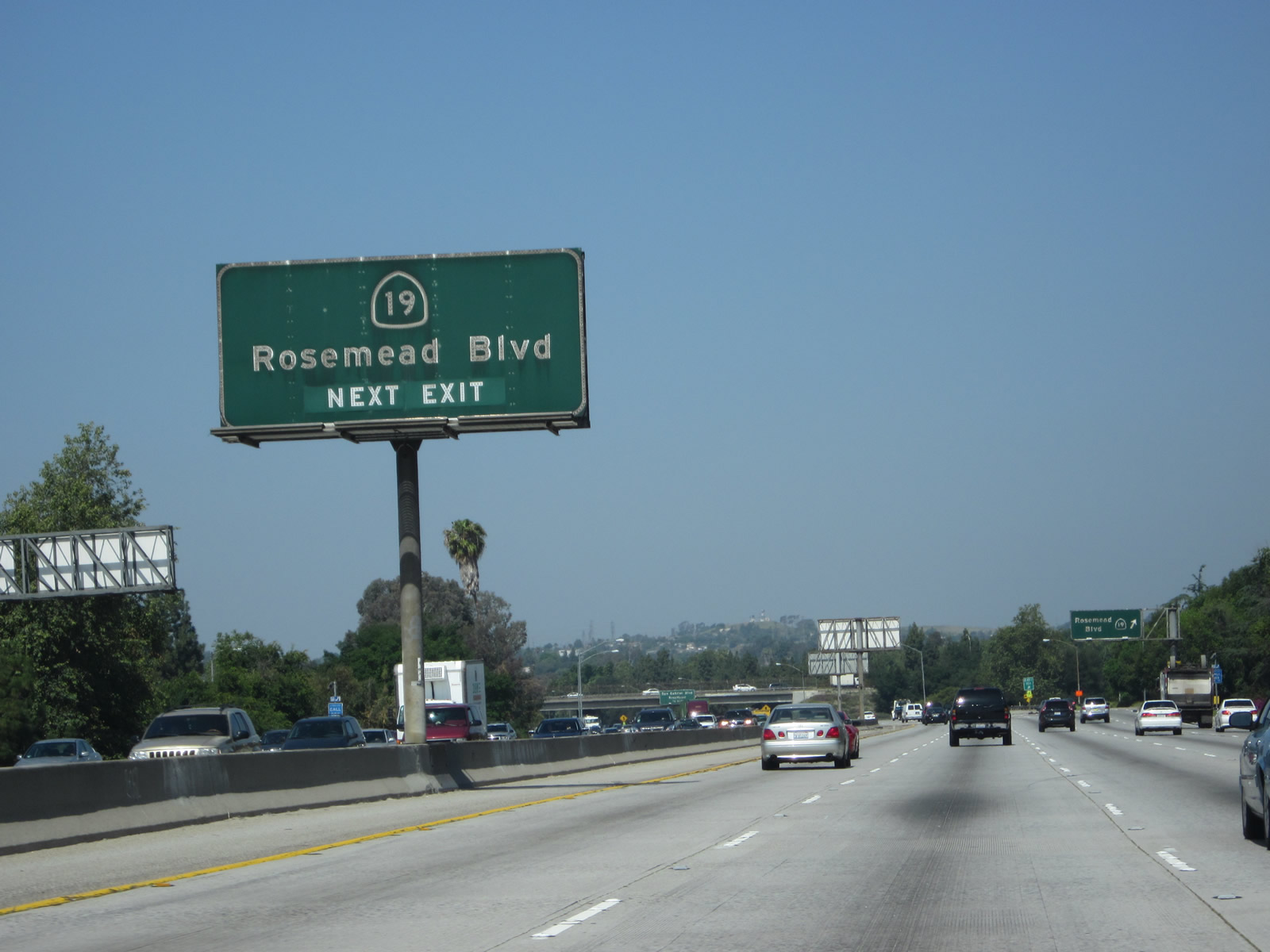
Westbound California 60 (Pomona Freeway) reaches Exit 10A, California 19 (Rosemead Boulevard). Photo taken 05/05/12. |
|
Passing under Rosemead Boulevard, the next exit along California 60 (Pomona Freeway) west is Exit 9, San Gabriel Boulevard. Photo taken 05/05/12. |
|
This mileage sign along California 60 (Pomona Freeway) west provides the distance to the next three exits: Exit 9, San Gabriel Boulevard; Exit 8, Paramount Boulevard; and Exit 6, Wilcox Avenue and Garfield Avenue. Photo taken 05/05/12. |
|
At the next interchange (Exit 9), California 60 briefly enters the southern tip of the city of Rosemead ("today's Small Town America"). Rosemead had a population of 53,505 as of the 2000 Census and was incorporated on August 4, 1958. Photo taken 05/05/12. |
|
Westbound California 60 (Pomona Freeway) reaches Exit 9, San Gabriel Boulevard to the city of Rosemead. California 60 briefly enters the city of Monterey Park ("Pride in the Past, Faith in the Future"). Monterey Park had a population of 60,051 as of the 2000 Census. California 60 generally stays north of Montebello and south of Monterey Park between Exits 9 and 6A. Photo taken 05/05/12. |
|
Passing under San Gabriel Boulevard, the next exit along California 60 (Pomona Freeway) west is Exit 8, Paramount Boulevard. Photo taken 05/05/12. |
|
The next two exits along California 60 (Pomona Freeway) west will serve the city of Montebello, which had a population of 62,150 as of the 2000 Census and was incorporated on October 19, 1920. Photo taken 05/05/12. |
|
This mileage sign along California 60 (Pomona Freeway) west provides the distance to the next two exits: Exit 8, Paramount Boulevard and Exit 6, Wilcox Avenue and Garfield Avenue. Photo taken 05/05/12. |
|
Westbound California 60 (Pomona Freeway) reaches Exit 8, Paramount Boulevard. Photo taken 05/05/12. |
|
Beyond the Paramount Boulevard overpass, the landfill rising in the background is a Superfund site. The Operating Industries Inc. landfill is located on both sides of the California 60 freeway. This landfill operated between 1948 and 1984, and due to hazardous materials contamination, it was designated as a Superfund site in 1986. Clean-up of the site has been underway since the Superfund designation, with capping completed in 2001 (south landfill) and 2009 (north landfill). Photo taken 05/05/12. |
|
A set of Southern California Edison power lines crosses over California 60 at the Paramount Boulevard interchange. A new 500kV power line, two sets of 220kV power lines, and several more 138kV power lines pass over the freeway. Photo taken 05/05/12. |
|
This mileage sign along California 60 (Pomona Freeway) west provides the distance to the next three exits: Exit 6, Wilcox Avenue and Garfield Avenue; Exit 4, Atlantic Boulevard; and Exit 3B, Interstate 710 (Long Beach Freeway). Photo taken 05/05/12. |
|
The right lane of California 60 (Pomona Freeway) west becomes exit only for Exit 6, Wilcox Avenue and Garfield Avenue. Photo taken 05/05/12. |
|
More power lines parallel California 60 (Pomona Freeway) on the north side of the freeway. Photo taken 05/05/12. |
|
This is another view of the same power line corridor alongside California 60 (Pomona Freeway). Photo taken 05/05/12. |
|
Westbound California 60 (Pomona Freeway) reaches Exit 6, Wilcox Avenue and Garfield Avenue. Photo taken 05/05/12. |
|
The power lines turn north and leave the freeway. Photo taken 05/05/12. |
|
This mileage sign along California 60 (Pomona Freeway) west provides the distance to the next three exits: Exit 4, Atlantic Boulevard; Exit 3B, Interstate 710 (Long Beach Freeway); and Exit 3A, Downey Road. This porcelain enamel sign is very old; the Interstate 710 shield covers up a California 7 route marker. California 7, and California 15 before 1964, were the older designations for what is now Interstate 710. Photo taken 05/05/12. |
|
Posted beyond a dynamic message board, a roadside sign indicates that the next couple of exits will serve the unincorporated community of East Los Angeles, which is a heavily Latino community located east of downtown Los Angeles and Boyle Heights. East L.A. is not an official city and takes its services from Los Angeles County. Debate continues as to whether the future of this community would be improved as an independent city. Photo taken 05/05/12. |
|
SR 60 westbound reassurance marker posted above the north side sound wall. Photo taken 05/05/12. |
|
The next exit along California 60 west is Exit 4, Atlantic Boulevard. Prior to the construction of the Long Beach Freeway, Atlantic Boulevard was the main north-south corridor between Long Beach and Pasadena. It was designated as California 15, and that designation was transferred onto the Long Beach Freeway as it was built in stages. California 15 / Atlantic Boulevard holds the distinction as serving as the southern/western terminus of U.S. 6 and U.S. 91 at the intersection between Atlantic Boulevard and Pacific Coast Highway in the city of Long Beach. California 15 was later transferred onto the Long Beach Freeway, and eventually it was renumbered as California 7 to avoid route number duplication with Interstate 15. Photo taken 05/05/12. |
|
A second reassurance marker for SR 60 west precedes the off-ramp (Exit 4) for Atlantic Boulevard. Photo taken 05/05/12. |
|
|
Westbound California 60 (Pomona Freeway) reaches Exit 4, Atlantic Boulevard. The following exit along California 60 west is Exit 3B, Interstate 710 (Long Beach Freeway). Photos taken 05/05/12. |
|
This mileage sign along California 60 (Pomona Freeway) west provides the distance to the next three exits: Exit 3B, Interstate 710 (Long Beach Freeway); Exit 3A, Downey Road; and Exit 2, Indiana Street. This porcelain enamel sign is very old; the Interstate 710 shield covers up another California 7 route marker. Photo taken 05/05/12. |
|
The left five lanes will continue west on California 60 (Pomona Freeway), while the right two lanes connect to Exit 3B, Interstate 710 (Long Beach Freeway). Originally designated as California 15, the Long Beach Freeway was renumbered as California 7 in 1964 to avoid confusion with newly created Interstate 15. When the Long Beach Freeway was added to the Interstate Highway System in 1983, California 7 was renumbered as Interstate 710. Some of the older signs associated with Interstate 710 still have an Interstate 710 route marker covering the original California 7 shield. Photo taken 05/05/12. |
|
Westbound California 60 (Pomona Freeway) meets Exit 3B, Interstate 710 (Long Beach Freeway). Interstate 710 is a major north-south freeway corridor connecting Long Beach and the ports of Long Beach and Los Angeles with the freeway system, ending at Valley Boulevard in Alhambra (near the campus of California State University at Los Angeles). This interchange is a symmetrical stack interchange, with high speed ramps for all directions of travel. Photo taken 05/05/12. |
|
Due to sight visibility issues on the approach to Exit 3B, another sign bridge has a second set of signs for the link from westbound California 60 (Pomona Freeway) to Exit 3B, Interstate 710 (Long Beach Freeway). The exit tab is placed in the center of the Interstate 710 exit sign, even though it should have been posted on the upper right corner due to the fact this is a right exit. Photo taken 05/05/12. |
|
Looking at the off-ramp to Interstate 710, the right lane will connect to Interstate 710 north to Valley Boulevard, and the left lane will connect to Interstate 710 south to Interstate 5 south and to Long Beach. Photo taken 05/05/12. |
|
The overhead sign on the transition ramp from California 60 west to Interstate 710 warrants a closer look. Note that the Interstate 710 shields were add-on plates that cover the old California 7 shield. Additionally, the Valley Boulevard control city is an overlay strip that likely covers the original northbound control city of Pasadena. That control city has been deemphasized due to the uncertainty as when if ever Interstate 710 will extend north into Pasadena to meet Interstate 210. Photo taken 05/05/12. |
|
This mileage sign along California 60 (Pomona Freeway) west provides the distance to the next three exits: Exit 3A, Downey Road; Exit 2, Indiana Street; and Exit 1D, Whittier Boulevard and Lorena Street. Photo taken 05/05/12. |
|
California 60 approaches the tangled web of freeway ramps that link California 60 with Interstate 710 in East Los Angeles. Photo taken 05/05/12. |
|
California 60 (Pomona Freeway) passes over the main lanes of Interstate 710 (Long Beach Freeway). The levels above California 60 make the connections between the 60 and 710 freeways. Photo taken 05/05/12. |
|
After the Interstate 710 stack interchange, the next interchange along California 60 (Pomona Freeway) west is Exit 3A, Downey Road south and Third Street east and west. The right lane becomes exit only for Downey Road. Photo taken 08/26/07. |
|
A California 60 west reassurance shield is posted after the Interstate 710 interchange and prior to the Downey Road and Third Street exit. Photo taken 08/26/07. |
|
|
This is the first advance sign for the East Los Angeles Interchange, which sees the junction of California 60 (Pomona Freeway), Interstate 10 (Santa Monica Freeway), Interstate 5 (Golden State Freeway) north, and U.S. 101 (Santa Ana Freeway), erroneously signed as Hollywood Freeway north. The second picture provides a clearer version of this increasingly unusual signs, since most newer signs deemphasize the freeway name and generally state the route number. Photos taken 08/26/07 and 05/05/12. |
|
|
Westbound California 60 (Pomona Freeway) reaches Exit 3A, Downey Road; the next exit is Exit 2, Indiana Street. These signs were replaced between 2007 and 2012. Photos taken 05/05/12 and 08/26/07. |
|
|
This mileage sign provides the distance to four of the final five exits on California 60 west: Exit 2, Indiana Street; Exit 1D, Whittier Boulevard and Lorena Street; Exit 1C, Interstate 5 (Golden State Freeway) north; Exit 1B, U.S. 101 (Santa Ana Freeway) north to Soto Street; and Exit 1A, Santa Fe Avenue and Mateo Street. After Exit 1A, California 60 west traffic is defaulted onto Interstate 10 (Santa Monica Freeway) west. Photos taken 05/05/12 and 08/26/07. |
|
|
Upon passing under the ramp from southbound Gage Avenue and Third Street to California 60 east, the right lane becomes exit only for Exit 2, Indiana Street. Photos taken 05/05/12 and 08/26/07. |
|
|
Westbound California 60 (Pomona Freeway) reaches Exit 2, Indiana Street. This is a half-diamond interchange with no direct return access to California 60 west. Photos taken 05/05/12 and 08/26/07. |
|
|
This mileage sign provides the distance to the next three exits on California 60 west: Exit 1D (1F), Whittier Boulevard and Lorena Street; Exit 1C, Interstate 5 (Golden State Freeway) north; Exit 1B, U.S. 101 (Santa Ana Freeway) north; Exit 1D, Soto Street. Photos taken 05/05/12 and 08/26/07. |
|
While passing under the Indiana Street overpass, westbound California 60 (Pomona Freeway) crosses the Los Angeles city line. Photo taken 08/26/07. |
|
|
Westbound California 60 (Pomona Freeway) reaches Exit 1D (1F), Whittier Boulevard and Lorena Street. Perhaps this should be Exit 1F since Exit 1D is also assigned to the off-ramp to Soto Street. Whittier Boulevard travels northwest to southeast; it originates in downtown Los Angeles as Sixth Street and used to carry U.S. 101 south until it was realigned onto the Santa Ana Freeway (now part of Interstate 5). Whittier Boulevard becomes a state highway (California 72) at the interchange with Interstate 605 and continues southeast to La Habra in Orange County. Lorena Street travels southwest to northeast, connecting to Los Angeles County Cemetery to the northeast and southbound Downey Road to the southwest. Photos taken 05/05/12 and 08/26/07. |
|
An exit number is posted at the gore point for Exit 1D (1F). At the top of the ramp is an intersection with Lorena Street. Turn left on Lorena Street to Old U.S. 101/Whittier Boulevard. Continue straight ahead to connect to East Sixth Street. Photo taken 08/26/07. |
|
|
California 60 enters the East Los Angeles Interchange. The right lane connects to Exit 1C, Interstate 5 (Golden State Freeway) north, and the #3 and #4 lanes connect to Exit 1B, U.S. 101 (Santa Ana Freeway) north to Soto Street. The left three lanes continue east on California 60 (Pomona Freeway) to Interstate 10 (Santa Monica Freeway) east. Photos taken 05/05/12 and 08/26/07. |
|
A final California 60 reassurance shield is posted prior to the East Los Angeles Interchange. Photo taken 08/26/07. |
|
|
From the East Los Angeles Interchange, Interstate 5 (Golden State Freeway) travels north to Glendale, the San Fernando Valley, and Santa Clarita before continuing through the Central Valley toward Sacramento and the San Francisco Bay Area. U.S. 101 follows the Santa Ana Freeway northwest to the Four-Level Interchange near downtown Los Angeles, then changes names to the Hollywood Freeway from there northwest to Hollywood and Universal City. Upon reaching California 134 (Ventura Freeway), U.S. 101 turns due west toward Ventura, Santa Barbara, and the Central Coast. Photos taken 05/05/12 and 08/26/07. |
|
|
Soto Street travels north-south through the East Los Angeles Interchange. Use Soto Street north into the Boyle Heights community of Los Angeles and south to the industrial areas along the Los Angeles River. Access to Soto Street is afforded via the ramp to Exits 1E-D-C, which are not numbered on this roadside sign. Photos taken 05/05/12 and 08/26/07. |
|
The westbound lanes of California 60 have a different alignment from the eastbound lanes. Here westbound California 60 passes under Euclid Avenue; the eastbound lanes travel over Euclid Avenue. Photo taken 08/26/07. |
|
|
California 60 splits, with the right three lanes connecting to Exit 1E & 1D, Interstate 5 (Golden State Freeway) north and Soto Street, and Exit 1C, U.S. 101 (Santa Ana Freeway) north. The left three lanes continue east on California 60 (Pomona Freeway) to Interstate 10 (Santa Monica Freeway) east. There is no access to Interstate 5 south, and U.S. 101 has its southern terminus at this interchange. Photos taken 05/05/12 and 08/26/07. |
|
|
Continuing west on California 60, this view shows the transition ramp to Exits 1C and 1B. Once on the "Exit 1C" transition ramp, the ramp will divide into Exits 1E, 1C, and 1D (although Calnexus does not define specific exit numbers for these three ramps). The first ramp connects to what is signed as Exit 1E, Interstate 5 (Golden State Freeway) north. The second ramp connects to Soto Street (signed as Exit 1D, even though Whittier Boulevard/Lorena Street are supposed to Exit 1D per Calnexus), and the remaining two lanes connect to U.S. 101 (Santa Ana Freeway) north (Exit 1C). California 60 (Pomona Freeway) narrows to Interstate 10 (Santa Monica Freeway) east. Photos taken 05/05/12 and 08/26/07. |
|
|
Looking at the transition ramp to U.S. 101 north again, the Soto Street off-ramp is labeled at the gore point as Exit 1C, even though the overhead sign reads Exit 1D. However, Calnexus defines the entire ramp to U.S. 101, Interstate 5, and Soto Street as Exit 1C. So a bit of confusion regarding exit numbers remains at the East Los Angeles Interchange. Photos taken 08/26/07 and 05/05/12. |
|
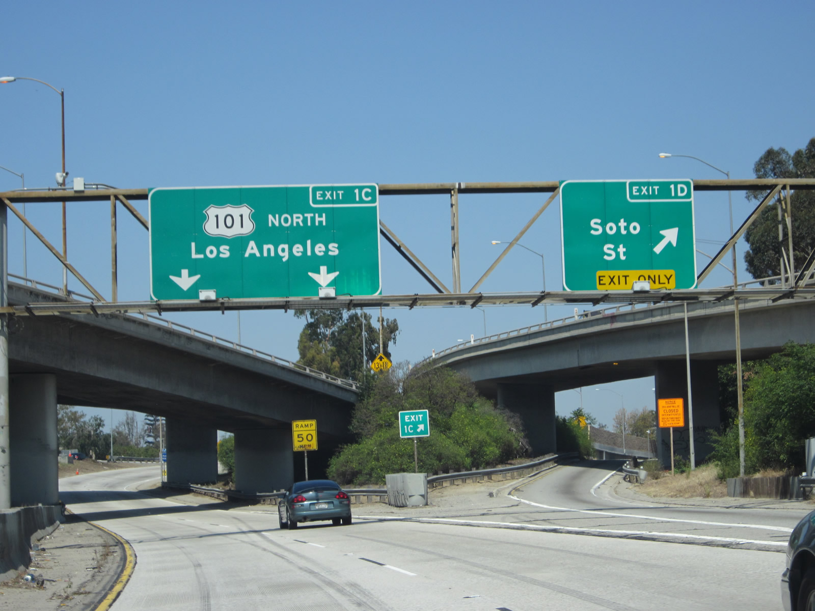
Traffic from westbound California 60 merges onto U.S. 101 (Santa Ana Freeway) north via Exit 1C. Photo taken 05/05/12. |
|
Back on the mainline, westbound California 60 passes under the northbound lanes of Interstate 5 (Golden State Freeway) and the off-ramp from Interstate 5 to Soto Street. Photo taken 08/26/07. |
|
Immediately thereafter, westbound California 60 passes under both northbound and southbound lanes of U.S. 101 (Santa Ana Freeway). Photo taken 08/26/07. |
|
Remaining below grade, California 60 passes under the transition ramp from U.S. 101 south to California 60 east and also the southbound lanes of Interstate 5. The third overpass in the distance carries Soto Street over California 60 in the East Los Angeles Interchange. Photo taken 08/26/07. |
|
The final exit along westbound California 60 (Pomona Freeway) is Exit 1A, Santa Fe Avenue and Mateo Street. The original exit number from the 1970s experiment is still valid and useful at this location. Merging traffic from joins the freeway from Soto Street. The sign bridge is posted on the Boyle Avenue overpass. A much higher viaduct visible to the left carries the eastbound lanes of California 60. Photo taken 08/26/07. |
|
Hiding in the shadows beneath the eastbound lanes of California 60 is a roadside sign for Los Angeles Street, which is an exit from Interstate 10 (Santa Monica Freeway) west. Photo taken 08/26/07. |
|
Westbound California 60 (Pomona Freeway) reaches Exit 1A, Santa Fe Avenue and Mateo Street. Photo taken 08/26/07. |
|
The gore point signage erroneously refers to Santa Fe Avenue and Mateo Street as Exit 1B; it should be Exit 1A. At this point, California 60 passes under the eastbound lanes of Interstate 10 (Santa Monica Freeway). Photo taken 08/26/07. |
|
Four lanes of westbound California 60 ascend onto the elevated section of Interstate 10 (Santa Monica Freeway). This famous scene shows the four lanes climbing between the eastbound and westbound lanes of Interstate 10. Photo taken 08/26/07. |
|
Traffic from California 60 west will merge onto Interstate 10 west from the left. Photo taken 08/26/07. |
|
California 60 comes to an end as the Pomona Freeway merges onto Interstate 10 (Santa Monica Freeway). From here, Interstate 10 travels west toward the city of Santa Monica and the beach. Photo taken 08/26/07. |
Page Updated October 8, 2012.